31 entries match your criteria.
Related Historical Markers
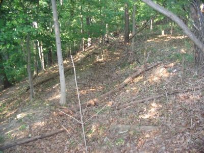
By Craig Swain, September 22, 2007
Section of the Trenches on Bolivar Heights
SHOWN IN SOURCE-SPECIFIED ORDER
| 1 ► West Virginia, Jefferson County, Bolivar — Bolivar Heights Trail — |
| On Whitman Avenue at Prospect Avenue (County Road 27/1), on the left when traveling north on Whitman Avenue. | |||
| 2 ► West Virginia, Jefferson County, Bolivar — Harpers Ferry — Prize of War — |
| On Whitman Avenue at Prospect Avenue, on the right when traveling south on Whitman Avenue. | |||
| 3 ► West Virginia, Jefferson County, Bolivar — Historic Heights — |
| On Whitman Avenue at Prospect Avenue, on the right when traveling west on Whitman Avenue. | |||
| 4 ► West Virginia, Jefferson County, Bolivar — Facing the Enemy — Harpers Ferry National Historical Park — National Park Service, U.S. Department of the Interior — |
| On Whitman Avenue at Prospect Avenue (County Road 27/1), on the left when traveling north on Whitman Avenue. | |||
| 5 ► West Virginia, Jefferson County, Bolivar — Closing the Doors — Harpers Ferry National Historical Park — National Park Service, U.S. Department of the Interior — |
| On Whitman Avenue at Prospect Avenue (County Road 27/1), on the left when traveling north on Whitman Avenue. | |||
| 6 ► West Virginia, Jefferson County, Bolivar — The First Year of War — |
| On Prospect Avenue at Whitman Avenue on Prospect Avenue. | |||
| 7 ► West Virginia, Jefferson County, Bolivar — Rats in a Cage — Harpers Ferry National Historical Park — National Park Service, U.S. Department of the Interior — |
| Near Prospect Avenue. | |||
| 8 ► West Virginia, Jefferson County, Bolivar — Casualties of War — |
| Near Whitman Avenue at West Washington Street (Alternate U.S. 340), on the left when traveling north. | |||
| 9 ► West Virginia, Jefferson County, Bolivar — A Union Predicament — |
| Near Whitman Avenue, 0.2 miles north of West Washington Street (Alternate U.S. 340), on the left when traveling north. | |||
| 10 ► West Virginia, Jefferson County, Bolivar — Confederate Victory — |
| Near Prospect Avenue. | |||
| 11 ► West Virginia, Jefferson County, Bolivar — Fortifying Bolivar Heights — |
| Near Whitman Avenue, 0.2 miles north of West Washington Street (Alternate U.S. 340), on the left when traveling north. | |||
| 12 ► West Virginia, Jefferson County, Bolivar — Protecting the Supply Lines — |
| Near Prospect Avenue. | |||
| 13 ► West Virginia, Jefferson County, Bolivar — Union Skirmish Line — |
| On Bakerton Road, on the right when traveling north. | |||
| 14 ► West Virginia, Jefferson County, Bolivar — From Skirmish Line to Burial Ground — Harpers Ferry National Historical Park — National Park Service, U.S. Department of the Interior — |
| Near Bakerton Road (County Route 27), on the right when traveling north. | |||
| 15 ► West Virginia, Jefferson County, Bolivar — We Began Firing At Will: The 111th New York Regiment — Harpers Ferry National Historical Park — National Park Service, U.S. Department of the Interior — |
| On Bakerton Road (County Route 27), on the right when traveling north. | |||
| 16 ► West Virginia, Jefferson County, Bolivar — A Dangerous Position — Harpers Ferry National Historical Park — National Park Service, U.S. Department of the Interior — |
| On Bakerton Road (County Route 27), on the right when traveling north. | |||
| 17 ► West Virginia, Jefferson County, Bolivar — Five Rounds into the Darkness — Harpers Ferry National Historical Park — National Park Service, U.S. Department of the Interior — |
| On Bakerton Road (County Road 27), on the right when traveling north. | |||
| 18 ► West Virginia, Jefferson County, Bolivar — The Confederate Perspective — Harpers Ferry National Historical Park — National Park Service, U.S. Department of the Interior — |
| Near Bakerton Road (County Route 27), on the right when traveling north. | |||
| 19 ► West Virginia, Jefferson County, Bolivar — A Position Strong by Nature — Harpers Ferry National Historical Park — National Park Service, U.S. Department of the Interior — |
| Near Bakerton Road (County Route 27), on the right when traveling north. | |||
| 20 ► West Virginia, Jefferson County, Bolivar — The First Line of Defense: The Union Skirmish Line — Harpers Ferry National Historical Park — National Park Service, U.S. Department of the Interior |
| Near Bakerton Road (County Route 27), on the right when traveling north. Reported permanently removed. | |||
| 21 ► West Virginia, Jefferson County, Bolivar — Battle of Harpers Ferry / Union Stronghold — Harpers Ferry National Historical Park — National Park Service, U.S. Department of the Interior — |
| On Prospect Avenue (County Road 27/1) at Whitman Avenue, on the left when traveling north on Prospect Avenue. | |||
| 22 ► West Virginia, Jefferson County, Bolivar — First Major Action — |
| 23 ► West Virginia, Jefferson County, Bolivar — Sheridan Fortifications — |
| Near Campground Road. | |||
| 24 ► West Virginia, Jefferson County, Bolivar — The Abatis — |
| Near Campground Road. | |||
| 25 ► West Virginia, Jefferson County, Bolivar — Infantry Positions — |
| Near Campground Road. | |||
| 26 ► West Virginia, Jefferson County, Bolivar — Gun Position #6 — |
| Near Campground Road. | |||
| 27 ► West Virginia, Jefferson County, Bolivar — Home Becomes Battlefield — Harpers Ferry National Historical Park — National Park Service, U.S. Department of the Interior — |
| Near Shoreline Drive. | |||
| 28 ► West Virginia, Jefferson County, Bolivar — Struggle to the Heights — Harpers Ferry National Historical Park — National Park Service, U.S. Department of the Interior — |
| Near Shoreline Drive. | |||
| 29 ► West Virginia, Jefferson County, Bolivar — The Fate of Harpers Ferry was sealed. — A.P. Hill — Harpers Ferry National Historical Park |
| Near Shoreline Drive. Reported unreadable. | |||
| 30 ► West Virginia, Jefferson County, Bolivar — Sheridan Dug In — Harpers Ferry National Historical Park — National Park Service, U.S. Department of the Interior — |
| Near Shoreline Drive. | |||
| 31 ► West Virginia, Jefferson County, Bolivar — Mountains, Men, and Maneuvers — Harpers Ferry National Historical Park — National Park Service, U.S. Department of the Interior — |
| Near Shoreline Drive. | |||