16 entries match your criteria.
Related Historical Markers
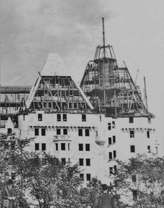
Library and Archives Canada, C-121478
Marker detail: Building the Château Laurier, 1911
SHOWN IN SOURCE-SPECIFIED ORDER
| 1 ► Ontario, Ottawa, Byward Market - Parliament Hill — Creating a Capital / Créer une Capitale — |
| On Mackenzie Avenue (Route 93) 0.2 kilometers south of Murray Street (Route 44), on the left when traveling south. | |||
| 2 ► Ontario, Ottawa, Byward Market - Parliament Hill — Meeting the World / À la rencontre du monde — |
| On Mackenzie Avenue (Route 93) 0.2 kilometers south of Murray Street (Route 44), on the left when traveling south. | |||
| 3 ► Ontario, Ottawa, Downtown Ottawa — Office of the Prime Minister and Privy Council — Bureau du Premier Ministre et du Conseil Privé — |
| On Wellington Street (Route 34) just east of Metcalfe Street (Route 89), on the left when traveling east. | |||
| 4 ► Ontario, Ottawa, Downtown Ottawa — National Press Building / L’Édifice national de la presse — Eyes and Ears of the Nation / Tout yeux, tout oreilles — |
| On Wellington Street (Route 34) west of O'Connor Street (Route 87), on the right when traveling west. | |||
| 5 ► Ontario, Ottawa, Downtown Ottawa — Bank of Canada / La Banque du Canada — Canada's Central Bank / La banque centrale du Canada — |
| On Wellington Street (Route 34) east of Kent Street (Route 83), on the left when traveling east. | |||
| 6 ► Ontario, Ottawa, Downtown Ottawa — Supreme Court of Canada / La Cour suprême du Canada — A Pillar of Canadian Democracy / Un pilier de la démocratie canadienne — |
| On Wellington Street (Route 34) just west of Kent Street (Route 83), on the right when traveling west. | |||
| 7 ► Ontario, Ottawa, Somerset Ward — The Capital's Forest Heritage / Le patrimoine forestier de la capitale — |
| On Portage Bridge just north of Wellington Street (Route 34), on the right when traveling north. | |||
| 8 ► Ontario, Ottawa, Major's Hill Park — People at an Ancient Crossroads / Un ancien point de jonction — A Modern Shoreline with a Rich Past / Des rives à l’allure moderne, mais riches d’histoire — |
| On Alexandra Bridge (Saint Patrick Street), 0.4 kilometers west of Mackenzie Avenue (Route 93), on the left when traveling west. | |||
| 9 ► Ontario, Ottawa, Orléans — Building for a New Canada / Construire un nouveau Canada — |
| On Alexandra Bridge (Saint Patrick Street), 0.4 kilometers west of Mackenzie Avenue (Route 93), on the left when traveling west. | |||
| 10 ► Ontario, Ottawa, Orléans — Wilderness Highway / Une route au beau milieu de la nature — |
| On Alexandra Bridge (Saint Patrick Street), 0.4 kilometers west of Mackenzie Avenue (Route 93), on the left when traveling west. | |||
| 11 ► Ontario, Ottawa, Byward Market - Parliament Hill — National Research Council Canada / Le Conseil National de Recherches du Canada — A World Leader / Un Chef de file Mondial — |
| On Sussex Drive (Route 93) just south of King Edward Avenue (Route 99), on the right when traveling south. | |||
| 12 ► Ontario, Ottawa, Byward Market - Parliament Hill — Rideau Canal National Historic Site of Canada — Lieu historique national du Canada du Canal-Rideau — |
| On Rideau Street close to Elgin Street when traveling west. | |||
| 13 ► Québec, Communauté-Urbaine-de-l'Outaouais, Gatineau — Deux cents ans d'essor / 200 Years in the Making — |
| On Laurier Street at Alexandra Bridge (Boulevard des Allumettières), on the right when traveling north on Laurier Street. | |||
| 14 ► Québec, Communauté-Urbaine-de-l'Outaouais, Gatineau — La Place du Portage / Place du Portage — Unifier la capitale / Uniting the Capital — |
| On Portage Bridge (Boulevard Maisonneuve) at Rue Laurier, on the right when traveling north on Portage Bridge (Boulevard Maisonneuve). | |||
| 15 ► Québec, Communauté-Urbaine-de-l'Outaouais, Gatineau — La Tour de Lessivage / The Digester Tower — Un hommage à notre patrimoine industriel / Monument to our industrial heritage — |
| On Rue Laurier at Rue Victoria, on the right when traveling north on Rue Laurier. | |||
| 16 ► Québec, Communauté-Urbaine-de-l'Outaouais, Gatineau — L’aménagement de la région de la capitale / Building a Capital Region — |
| On Portage Bridge (Boulevard Maisonneuve), 0.2 kilometers south of Rue Laurier, on the left when traveling south. | |||