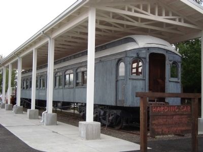
Used by President Warren G. Harding on his trip to Alaska in 1923 to drive the Golden Spike for the Alaska Railroad. “Denali" is the Indian name for Mt. McKinley, the “Great One.” — — Map (db m219066) HM
On Front Street east of George Parks Highway (Alaska Route 3), on the right when traveling east.
President Warren G. Harding, first U.S. President to visit Alaska traveled here to pound the Golden Spike signalling completion of the Alaska Railroad from tidewater to the interior July 15, 1926.
State of Alaska
Governor Walter J. Hickel . . . — — Map (db m42948) HM
On 16th Street Northwest just south of Fuller Street Northwest, on the right when traveling south.
Maria Skłodowska-Curie, born in 1867 in Warsaw, was a visionary scientist whose discoveries paved the way for effective cancer treatments and created the foundations of several scientific disciplines.
Maria Skłodowska-Curie was . . . — — Map (db m175121) HM
On Wisconsin Avenue Northwest north of Quebec Street Northwest, on the left when traveling north.
Friendship was the country estate for two generations of the McLean family. The English style manor house “Eden Bower” was built around 1800 by British Col. Richard Pyle. Pyle was succeeded by Georgetown University, which used the . . . — — Map (db m152176) HM
On 16th Street Northwest north of Irving Street Northwest, on the left when traveling north.
Beginning in the late 1950s, the community leadership of Mount Pleasant changed from the exclusive Citizens Association to an array of new players. Mount Pleasant Neighbors Association was the first alternative group. It presented festivals and . . . — — Map (db m148598) HM
On Pennsylvania Avenue Northwest at 14th Street Northwest (Highway 1), on the right when traveling west on Pennsylvania Avenue Northwest.
Site of
Joshua Tennison's Hotel 1818. John Strother 1821. Basil Williamson 1824. Frederick Barnard 1828. Proprietor of Mansion Hotel, Azariah Fuller American House 1833. City Hotel 1843. Willard's Hotel 1847-1901.
Distinguished Guests . . . — — Map (db m6618) HM
On Wyoming Avenue Northwest at 23rd Street Northwest, on the right when traveling east on Wyoming Avenue Northwest. Reported damaged.
Five presidents lived in Sheridan-Kalorama between 1916 and 1930. Warren G. Harding lived at 2314 Wyoming Avenue while a senator from Ohio. William Howard Taft lived across the street at 2215 Wyoming Avenue while Chief Justice of the Supreme Court . . . — — Map (db m112606) HM
Near Arnold Avenue Southwest, 0.1 miles north of Tinker Street Southwest, on the left when traveling north.
[Panel 1]:
Old Bolling Field
1917 - Survey for the site of a military flying field to be used for defense of Washington and for proficiency flying. Captain William "Billy" Mitchell, commander of Army Signal Corps Aeronautics . . . — — Map (db m63896) HM
The exact year the Roesch house was built is unknown. It was probably constructed sometime after 1892. It was constructed by William Russell Roesch. Roesch was made city treasurer of Eau Gallie in 1887. Roesch was also mayor of Eau Gallie numerous . . . — — Map (db m49136) HM
On John Ringling Boulevard near St Armands Circle, in the median.
In 1923 circus magnate John N. Ringling (1866-1936) purchased St. Armands Key, an uninhabited, 150-acre, oval shaped island. He planned a community of fine residences with a central circle park surrounded by shops. The park was named in memory of . . . — — Map (db m32407) HM
The St. Augustine office of the National Association for the Advancement of Colored People (NAACP) was located in this building from the 1970's until the early 1990's. The organization's roots in the Ancient City began much earlier. William English . . . — — Map (db m21181) HM
On Peachtree Street at Ponce de Leon Avenue, on the right when traveling north on Peachtree Street.
Built by Atlanta native, Joseph Gatins and designed by New York Architect, W. L. Stoddard, the Terrace opened October 2, 1911. Over the years most of Atlanta’s famous visitors have chosen the Georgian Terrace Hotel as their temporary home on . . . — — Map (db m47425) HM
Near Loop Creek Road (Federal Road 506) 4 miles west of Cliff Creek Road (Federal Road 326).
The Unknown Locomotive
Called the “unkown” locomotive by some rail enthusiasts, few people now recognize the heavyweight of the Milwaukee’s Rocky Mountain Division, the Baldwin-Westinghouse EP-3.
Between 1919 and . . . — — Map (db m45630) HM
On Florence Avenue south of Monroe Street, on the right when traveling south.
Commissioned by William Sherman Cook; built by J. D. Bragg in
1904 1905. Mr. Cook was born in Simcoe Province, Ontario,
Canada. He bought this property in 1901, originally a tract
of 10 acres bordered by Monroe, Florence, Olive, and Cook
Avenue, . . . — — Map (db m124896) HM
The heroic bronze figure in front of you is not, as many suppose, a likeness of Francis Scott Key. The statue represents Orpheus, the artful poet, musician, and singer of Greek Mythology.
In 1914 Congress appropriated funds for a . . . — — Map (db m707) HM
On South Market Street (Maryland Route 355) south of Fox's Alley, on the right when traveling south.
The man Americans honor as the author of "The Star-Spangled Banner" began his life and career in Frederick County, Maryland. Here he first learned the American values that guided his life.
Key was a child of the American Revolution, and saw . . . — — Map (db m198000) HM
Near Main Street (Massachusetts Route 10) at Masonic Street, on the right when traveling east.
By the mid 19th century the simple elegance of Northampton's buildings began to give way to the tastes and fashions of a new era of commercialism. William Fenno Pratt, who designed many of the Victorian buildings on Main Street, conceived of the . . . — — Map (db m138436) HM
On U.S. 302, 0.3 miles east of Mt Clinton Road, on the right when traveling east.
Abel Crawford and son, Ethan Allen Crawford, built the first Crawford House in 1828. It was run by Ethan's brother, Thomas, until sold in 1852. Fires in 1854 and 1859 destroyed the original inn and a replacement. Col. Cyrus Eastman erected the . . . — — Map (db m75236) HM
On Boardwalk just east of South Iowa Avenue, on the right when traveling west.
Former Ritz Carlton Hotel opened during the "Roaring Twenties" on June 24, 1921 as one of Atlantic City's Grand Hotels.
Designed by the architectural firm of Warren and Wetmore and constructed at a cost of $6 million.
During WW2 the . . . — — Map (db m208348) HM
On Stockton Street at Bayard Street on Stockton Street.
Here memory lingers to recall the guiding mind whose daring plan outflanked the foe and turned dismay to hope when Washington, with swift resolve, marched through the night to fight at dawn and venture all in one victorious battle for our freedom. . . . — — Map (db m5379) HM
On Stockton Street (U.S. 206), on the left when traveling north.
This monument, which commemorates the January 3, 1777 Battle of Princeton, depicts Liberty inspiring General Washington as he leads his troops into battle, and the death of General Hugh Mercer. The seals of the United States and the original . . . — — Map (db m62293) HM
On East Avenue (U.S. 40) at School Lane, on the left when traveling west on East Avenue.
U.S. President Warren Harding 1922
U.S. President Warren G. Harding was traveling by car from Penns Grove to Atlantic City on May 12, 1922 when he stopped briefly in Woodstown and addressed a local crowd at the Woodstown Public School. New . . . — — Map (db m157199) HM
On Easton Turnpike (New Jersey Route 28) at Entrance to PC Richard & Burger King, on the left when traveling west on Easton Turnpike.
On this site stood the estate of U.S. Senator Joseph S. Frelinghuysen. It was here, on July 2, 1921, that President Warren G. Harding signed a joint congressional resolution that officially ended World War I. — — Map (db m70542) HM
Working from his house and publishing through the American Natural History Museum, Earl Morris intrigued the nation with his findings at Aztec Ruins.
In 1923 the site Morris had known since boyhood was preserved as a national monument . . . — — Map (db m71078) HM
On 59th Street at Avenue of the Americas, on the right when traveling west on 59th Street.
One of a trio of bronze equestrian sculptures representing Latin American leaders, the Simon Bolivar statue commemorates a military general and advocate of Pan-Americanism. Bolivar (1783-1840) is credited with the liberation from Spanish . . . — — Map (db m42569) HM
On Broadway at Bowling Green, on the right when traveling south on Broadway.
This tablet dedicated to the memory of the men of the American Merchant Marine who gave their lives in the World War that liberty should perpetually endure. “These men rendered one of the greatest services that could have been done for our . . . — — Map (db m20289) HM
On East 64th Street at Madison Avenue, on the right when traveling east on East 64th Street.
The lawyer and former New York governor lived here from 1917 to 1921, after losing the 1916 presidential elections to Woodrow Wilson. Hughes served as U.S. Secretary of State during the Harding Administration (1921-23) and the Coolidge . . . — — Map (db m98645) HM
On Amsterdam Avenue south of West 99th Street, on the right when traveling north.
Located at West 96th Street and Amsterdam Avenue, this playground and the adjoining school honor four-term New York Governor Alfred Emanuel Smith (1873-1944). The son of Irish immigrants, Smith dropped out of school to help support his family. . . . — — Map (db m242774) HM
Near Pine Street, 0.2 miles north of E Tioga Street, on the left when traveling north.
1921 Year the Bridge was Completed
92.3’ Each Arch Span Length
752’ Total Bridge Length
41’ Each Arch length
This bridge was built in 1921, when Warren G. Harding was president of the United States. It closed to motor vehicles in 1981, . . . — — Map (db m144164) HM
Susan Brownell Anthony
Woman Suffrage Leader
Visited October 19, 1878
"To secure both national and 'domestic tranquility,' to 'establish justice,' to carry out the spirit of our Constitution, put into the hands of all women....the . . . — — Map (db m53838) HM
On Heaton Street, on the right when traveling south.
Warren Gard (1873-1929), son of Samuel Z. Gard and Mary Duke, was born in Hamilton, Ohio. He established his practice in Hamilton after graduating from Cincinnati Law School and being admitted to the Ohio Bar in 1894. Gard served as Butler County . . . — — Map (db m122416) HM
[Mural is on both sides of brick walls on the northern end of town that lie on both sides of the street:]
Wellsville Revitalization Committee Picnic
"Riverside"
Presbyterian Church, USA
525 Riverside Ave.
Founded April 5, 1831 . . . — — Map (db m156060) HM WM
One of Ohio's most influential politicians in the early 20th century, Washington Court House native Harry Daugherty (1860-1941) was widely known as a "President-maker" and served instrumental roles in President Warren G. Harding's administration, . . . — — Map (db m27820) HM
On Auburn Avenue, on the left when traveling south.
William Howard Taft. Born here on September 15, 1857, William Howard Taft is the only American to have served as President and Chief Justice of the United States. His unique career of public service began after he graduated from Yale . . . — — Map (db m168978) HM
On Ohio Route 58 at Ohio Route 162, on the right when traveling north on State Route 58.
Side one:
Horr Cheese House, 1865
As late as the Civil War era, cheesemaking in Ohio remained largely a cottage industry. After investigating new processes and obtaining pledges for a reliable milk supply from area farmers, brothers . . . — — Map (db m38814) HM
On East Center Street (Ohio Route 309) at Sharpless Ct, on the right when traveling west on East Center Street.
Thomas Stinson Cummin, owner of a successful dry
goods store, built his home in the early 1870s on
the outskirts of the growing village of Marion. The
home was purchased in 1889 by Henry M. Barnhart,
an inventor, and co-founder of the Marion . . . — — Map (db m221680) HM
Near Delaware Avenue (Ohio Route 423) at Vernon Heights Boulevard, on the right when traveling north.
Warren Gamaliel Harding
Warren Gamaliel Harding was born November 2, 1865, in Blooming Grove, Ohio, to Dr. George Tryon Harding and Phoebe Dickerson Harding. The family moved to the village of Caledonia, and then to Marion.
Harding . . . — — Map (db m219208) HM
On Mt. Gilead-Iberia Galion Road (County Road 30) at Local Road 49, on the right when traveling north on Mt. Gilead-Iberia Galion Road.
Warren G. Harding, 29th President of the United States, graduated in 1882 from the college formerly located here. While a student, Harding and a friend founded the school newspaper, “The Iberia Spectator.” — — Map (db m19779) HM
On West Main Street (Oklahoma Route 199) west of B Street NW, on the right when traveling west.
Before 1899, J.W. Banks built, at this site, a mercantile establishment combined with lodging quarters. In 1903, W.F. (Dixie) Gilmer arrived from North Carolina and leased the hotel which was a three story structure with rooms on the second and . . . — — Map (db m142422) HM
Near Old Oregon Trail near Interstate 84, on the left when traveling north.
(Six panels dealing with the Emigrant Springs portion of the Oregon Trail are found beneath this kiosk)
Lost Livestock
Water is scarce in the steep, forested slopes of the Blue Mountains and is often found only at . . . — — Map (db m111537) HM
On Old Highway 30 near Main Street, on the right when traveling north.
First known as Lee's Encampment,
from establishment of a troop
camp by Major H.A.G. Lee in 1844,
A.B. and Harvey Meacham operated
famous "Mountain House" here, which
gave the town its present name.
In later years a famous railroad
eating . . . — — Map (db m111530) HM
Dedicated to the memory of
The Intrepid Pioneers
Who came with the
First Wagon Train
In 1843 over the
Old Oregon Trail
And Saved the "Oregon County"
To the United States.
Erected by Old Oregon Trail Ass'n.
July 4, . . . — — Map (db m111533) HM
Near O'Hara Street at Thackeray Street, on the right when traveling west.
In commemoration of
Maria Sklodowska Curie
A Polish scientist
Discoverer of Radium and Polonium
Conferred Degree of Doctor of Laws
By the University of Pittsburgh on May 26th, 1921
Inspecting facilities of Standard Chemical Company at . . . — — Map (db m127227) HM
On Gap Road (Pennsylvania Route 741) east of Bishop Road, on the right when traveling east. Reported missing.
The Success of the K4s Locomotive: Perpetually searching for more powerful and efficient locomotives, the Pennsylvania Railroad introduced its new standard passenger power in 1914. The K4s Pacific blended the best attributes of other successful . . . — — Map (db m19955) HM
On East Wyoming Avenue at North Cebada Street, on the right when traveling west on East Wyoming Avenue.
Henry Ossian Flipper (1856-1940) was the first African-American graduate of the United States Military Academy at West Point in 1877. Born into slavery in Thomasville, Georgia, he came from a family of achievers; his brothers were an African . . . — — Map (db m60727) HM
On North Main Street at East 200 North, on the right when traveling south on North Main Street.
Built in 1923, the Cedar City Railroad Depot is historically significant for its direct association with the railroad and its impact on Cedar City. In addition to stimulating the local iron ore and livestock industries, the railroad connection to . . . — — Map (db m59566) HM
On North Main Street (Utah Route 130) south of Iron Mission Parkway (West 685 North), on the right when traveling south.
The caboose provided the train crew with shelter and working space while they threw switches and inspected for problems such as shifting loads, overheated axle bearings, and dragging equipment. The conductor used the caboose for filling out various . . . — — Map (db m130597) HM
Near Constitution Highway (Virginia Route 20) 1.7 miles west of Germanna Highway (Virginia Route 3).
Marker Front: The Wilderness of today looks little like the tangled landscape soldiers found here in 1864. For decades before the war, loggers had cut and recut these forests to fuel nearby iron furnaces, leaving behind an impenetrable . . . — — Map (db m59518) HM
On West Charity Street at Saint Peter Street on West Charity Street.
Charles Sidney Gilpin grew up here in Jackson
Ward. He apprenticed in the Richmond Planet
print shop before beginning his theater career
and becoming one of the most highly regarded
actors of the 1920s. Gilpin is best known for
his title . . . — — Map (db m107932) HM
On Fort Caspar Road, 0.1 miles west of Wyoming Route 258, on the right when traveling west.
The famous Salt Creek oil field is located in Natrona County, 40 miles north of Casper. Representative Stephen W. Downey was the first man to acquire land at Salt Creek in 1883, after the discovery of the Jackass Spring oil seep. The discovery oil . . . — — Map (db m164528) HM
On C Street near Navy Row, on the right when traveling north.
“Get out and don’t come back!” was the message John Hunton and his oil prospecting party received in 1873 from a mounted band of Arapahoe Indians while filling glass jars with pure crude oil seeping from the sandy ground. This is the . . . — — Map (db m95627) HM
On State Highway 259, 4.5 miles north of Exit 210 (Interstate 25), on the right when traveling north.
Teapot Rock is an outcropping of sandstone whose general outline resembles a teapot—though harsh weather has collapsed both handle and spout. Taking place nearby, the Teapot Dome Scandal “erupted like a gusher” in 1924, rocking . . . — — Map (db m92160) HM
Thomas Mellon was born in this cottage on February 3rd, 1813. It was built by his father and uncle a few years earlier "chiefly by the labour of their own hands" and stood on a Twenty-three acre farm cut out of his grandfather's larger estate. . . . — — Map (db m85967) HM