By Barry Swackhamer, July 24, 2010
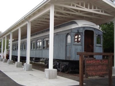
The Harding Car and Marker
| On Front Street east of George Parks Highway (Alaska Route 3), on the right when traveling east. |
| On 16th Street Northwest just south of Fuller Street Northwest, on the right when traveling south. |
| On Wisconsin Avenue Northwest north of Quebec Street Northwest, on the left when traveling north. |
| On 16th Street Northwest north of Irving Street Northwest, on the left when traveling north. |
| On Pennsylvania Avenue Northwest at 14th Street Northwest (Highway 1), on the right when traveling west on Pennsylvania Avenue Northwest. |
| On Wyoming Avenue Northwest at 23rd Street Northwest, on the right when traveling east on Wyoming Avenue Northwest. Reported damaged. |
| Near Arnold Avenue Southwest, 0.1 miles north of Tinker Street Southwest, on the left when traveling north. |
| On John Ringling Boulevard near St Armands Circle, in the median. |
| On Washington Street when traveling south. |
| On Peachtree Street at Ponce de Leon Avenue, on the right when traveling north on Peachtree Street. |
| Near Loop Creek Road (Federal Road 506) 4 miles west of Cliff Creek Road (Federal Road 326). |
| On Walnut Street at Avenue B, on the left when traveling south on Walnut Street. |
| On Florence Avenue south of Monroe Street, on the right when traveling south. |
| On South Market Street (Maryland Route 355) south of Fox's Alley, on the right when traveling south. |
| Near Main Street (Massachusetts Route 10) at Masonic Street, on the right when traveling east. |
| On U.S. 302, 0.3 miles east of Mt Clinton Road, on the right when traveling east. |
| On Boardwalk just east of South Iowa Avenue, on the right when traveling west. |
| On Stockton Street at Bayard Street on Stockton Street. |
| On Stockton Street (U.S. 206), on the left when traveling north. |
| On East Avenue (U.S. 40) at School Lane, on the left when traveling west on East Avenue. |
| On Easton Turnpike (New Jersey Route 28) at Entrance to PC Richard & Burger King, on the left when traveling west on Easton Turnpike. |
| On 59th Street at Avenue of the Americas, on the right when traveling west on 59th Street. |
| On Broadway at Bowling Green, on the right when traveling south on Broadway. |
| On East 64th Street at Madison Avenue, on the right when traveling east on East 64th Street. |
| On Amsterdam Avenue south of West 99th Street, on the right when traveling north. |
| Near Pine Street, 0.2 miles north of E Tioga Street, on the left when traveling north. |
| On Heaton Street, on the right when traveling south. |
| On Lisbon Street at 1st Street on Lisbon Street. |
| On Auburn Avenue, on the left when traveling south. |
| On Ohio Route 58 at Ohio Route 162, on the right when traveling north on State Route 58. |
| On East Marion Street just east of Peach Alley, on the right when traveling east. |
| On East Center Street (Ohio Route 309) at Sharpless Ct, on the right when traveling west on East Center Street. |
| Near Delaware Avenue (Ohio Route 423) at Vernon Heights Boulevard, on the right when traveling north. |
| On Mount Vernon Avenue (Ohio Route 95), on the right when traveling west. Reported missing. |
| On Ohio Route 97, 0.2 miles east of Williamsport-Bloomingrove Road (County Route 20), on the left when traveling east. |
| On Mt. Gilead-Iberia Galion Road (County Road 30) at Local Road 49, on the right when traveling north on Mt. Gilead-Iberia Galion Road. |
| On West Main Street (Oklahoma Route 199) west of B Street NW, on the right when traveling west. |
| Near Old Oregon Trail near Interstate 84, on the left when traveling north. |
| On Old Highway 30 near Main Street, on the right when traveling north. |
| On Old Oregon Trail near Interstate 84. |
| Near O'Hara Street at Thackeray Street, on the right when traveling west. |
| On Gap Road (Pennsylvania Route 741) east of Bishop Road, on the right when traveling east. Reported missing. |
| On East Wyoming Avenue at North Cebada Street, on the right when traveling west on East Wyoming Avenue. |
| On North Main Street at East 200 North, on the right when traveling south on North Main Street. |
| On North Main Street (Utah Route 130) south of Iron Mission Parkway (West 685 North), on the right when traveling south. |
| Near Constitution Highway (Virginia Route 20) 1.7 miles west of Germanna Highway (Virginia Route 3). |
| On West Charity Street at Saint Peter Street on West Charity Street. |
| On Fort Caspar Road, 0.1 miles west of Wyoming Route 258, on the right when traveling west. |
| On C Street near Navy Row, on the right when traveling north. |
| On State Highway 259, 4.5 miles north of Exit 210 (Interstate 25), on the right when traveling north. |
| Near Mellon Road north of Beltany. |