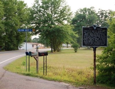
On Dunklin Bridge Road (State Highway S-23-68) at Sullivan Grove Way on Dunklin Bridge Road.
The cemetery located about ½ mile north, marks the site of Grove Church, established prior to 1790, one of the first Methodist churches in Greenville County. The present church, renamed Lebanon, is located about 1¼ miles W. of here. A number . . . — — Map (db m9021) HM
Near Cedar Falls Road at Turner Road, on the right when traveling north.
Settled in the 1780’s, Fork Shoals was not a typical Southern textile mill village where residents earned their living solely at the mill. The community was primarily agrarian and the people supplemented their farm income by working at the mill. . . . — — Map (db m198572) HM
On Jones Mill Road (County Road 191), on the right when traveling north.
Stone's Mill:
The first grist mill on Big Durbin Creek was built about 1813 for John Bruce (d. 1818), a veteran of the American Revolution, who also ran a sawmill and woolen mill here. The present mill, built by slave labor before 1860, is made . . . — — Map (db m43522) HM
On South Main Street (State Highway 124), on the left when traveling south.
Near Reedy River Falls, stood the home, trading station, and grist mill of Col. Richard Pearis, first white settler of this section. He was a noted Indian trader and prominent Tory of the Revolution. — — Map (db m10428) HM
On South Main Street (State Highway 124) at East Broad Street on South Main Street.
As a tribute to his skills exploiting enemy weaknesses, Pickens became known as the "Wizard Owl" or "Skyagunsta" - a bird known for seeing clearly, acting wisely and striking quickly.
Pickens was a tall, religious Presbyterian from . . . — — Map (db m11253) HM
On South Main Street (State Highway 124) near East Broad Street.
Battle hardened in the Cherokee War of 1760-61 and the battle of Sullivan's Island in 1776, Marion was 48 years old when the British invaded & conquered SC in 1780.
His volunteer militia detachment operated primarily in the lowcountry attacking . . . — — Map (db m10806) HM
On Furman College Way, on the right when traveling east.
Established in 1826 in Edgefield as an academy and theological institution, Furman University was charted in 1850 and in 1851 established a campus on the bluff above this spot, where it remained for the next century. Named for Baptist minister . . . — — Map (db m14549) HM
Hero of the American Revolutionary War
Recognized Namesake of Greenville, South Carolina
Born: August 7, 1742, Potowomut, RI
Died: June 19, 1786, Mulberry Grove, GA
The son of Rhode Island Quakers, General Nathanael Greene rose . . . — — Map (db m168949) HM
On South Main Street (State Highway 124) near East Broad Street.
Have you heard the story of General Greene,
A Rhode Island private who followed his dream.
In 1780 as Washington's man
He came to our state to free our great land.
Armies of British were sent by the King,
But they were no match for the . . . — — Map (db m21828) HM
On South Main Street at Broad Street, on the left when traveling south on South Main Street.
This flag, often referred to as the Guilford Courthouse Flag, is an example of the diversity of American flags during the Revolutionary War period. It has the unique design elements of an elongated canton with white background and 13 blue, . . . — — Map (db m10863) HM
On Falls Street near Camperdown Way (South Carolina Highway 124).
Richard Pearis, Greenville's first white settler, was an Irish adventurer who had settled in Virginia with his wife and family by the middle of the eighteenth century. He developed good trade relationships with the Cherokee Indians, had a son by an . . . — — Map (db m8035) HM
An adventurous hero or an opportunistic traitor, Richard Pearis led a life touched by many of colonial America's defining themes. Leaving Virginia, he settled by the Reedy River in 1768 and is credited with being the first to harness local . . . — — Map (db m20205) HM
On East Broad Street at Main Street, on the left when traveling west on East Broad Street.
This flag, commonly referred to as "The Betsy Ross Flag," was adopted June 14, 1777 (Flag Day). The Continental Congress on this day resolved "That the flag of the United States be thirteen stripes alternating red and white; that the Union be . . . — — Map (db m10853) HM
On South Main Street near Broad Street, on the left when traveling south.
This flag, commonly referred to as "The Moultrie Flag," was carried by Colonel William Moultrie's South Carolina Militia on Sullivan's Island in Charleston Harbor on June 28, 1776. The British were defeated that day which saved the South from . . . — — Map (db m10864) HM
On East Broad Street at Main Street on East Broad Street.
Our South Carolina state flag represents one of the oldest flag designs still in use. Its design elements go back to 1765 when three white crescents were used on a blue flag by protesters against the Stamp Act. Ten years later, a flag with a single . . . — — Map (db m10856) HM
On South Main Street (State Highway 124) at East Broad Street on South Main Street.
The most controversial of Greene's Militia commanders, Sumter was known for his trademark gamecock feather in his hat, his tenacity and his penchant for bloody frontal assaults - characteristics that earned him the moniker "The Gamecock."
. . . — — Map (db m10807) HM
Built by Henry Middleton on land bought from Elias Earle in 1813, Whitehall served as his summer home until 1820 when it was sold to George W. Earle, whose descendants have occupied it ever since. Henry Middleton was son of Arthur Middleton, signer . . . — — Map (db m9085) HM
On State Highway 101 at Oneal Church Street, on the right when traveling south on State Highway 101. Reported missing.
(front)
John Jane Black Thomas emigrated to S.C. c.1755 from Chester Co., PA. John was a local magistrate and militia captain. As the Revolutionary War began, he was elected Colonel of the Spartan Regiment. Captured in 1779, he was held in . . . — — Map (db m198226) HM
On Fork Shoals Road south of Old Hundred Road (County Road 565), on the right when traveling north.
Here along the south side of the creek to Reedy River was fought, Dec. 22, 1775, the Battle of Great Cane Break, between a force of South Carolinians under Colonel William Thompson and a band of Tories under Patrick Cuningham. The Tories were . . . — — Map (db m97258) HM
On Wade Hampton Boulevard (U.S. 29) at Artillery Road, on the left when traveling north on Wade Hampton Boulevard.
This camp, named in honor of John Sevier, Lieut. Col., N.C. militia, 1777, Col., 1781, Brig. Gen., U.S.P.A., 1796, was approved as cantonment site May 21, 1917. The 30th Division trained here from August 28, 1917 to May 1, 1918; the 81st, from May . . . — — Map (db m10475) HM
On Tigerville Road, 1.3 miles east of U.S. 25, on the right when traveling east.
On this site
stood the home of
Laodicea Langston Springfield
("Dicey")
1759 - 1837
Heroine of
the American Revolution.
To her daring and courage
many patriots owed their lives.
This rock was
a hearthstone in her home. . . . — — Map (db m10301) HM