On North Curry Street, on the right when traveling north.
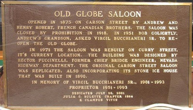
Opened in 1875 on Carson Street by Andrew and Henry Robert, French Canadian brothers. The saloon was closed by prohibition in 1918. In 1951 Bob Golightly, Andrew’s grandson asked Virgil Bucchianeri to reopen the Old Globe.
In 1971 the saloon was . . . — — Map (db m174112) HM
On North Carson Street at West Second Street when traveling north on North Carson Street.
Carson Citys first hotel site bought by Major William Ormsby in 1859 from M. Stebbins, completed after his death in the 1860 Indian War. The hotel was the first polling place in Carson City also meeting place of early lawmakers. It was lighted by . . . — — Map (db m174114) HM
On West Bonanza Road (Nevada Route 579), on the right when traveling west.
The first integrated hotel and casino in Las Vegas, the Moulin Rouge opened in May 1955. It is celebrated as a landmark of racial integration in Las Vegas and the United States.
Entertainers from the Las Vegas Strip and Hollywood flocked to . . . — — Map (db m51047) HM
The first school in West Las Vegas opened with two rooms and two teachers for four grades.
From 1904 until 1923, children from McWilliams' Townsite crossed the railroad tracks to get to school in Clark's Townsite. This dangerous situation . . . — — Map (db m51054) HM
On West Bonanza Road at North Tonopah Drive, on the right when traveling west on West Bonanza Road.
Colorful Horseshoe Club owner Benny Binion and his family lived here from 1947 to 1989.
Originally built in 1942 by service station owner C.A. Morehouse, the home was one of the largest in Las Vegas with three bedrooms, several baths, a . . . — — Map (db m51045) HM
On Las Vegas Boulevard South, on the right when traveling east.
On this site Benjamin “Bugsy” Siegel's original Flamingo Hotel stood from December 26, 1944 until December 14, 1993.
The hotel, which housed 77 rooms, including the notorious Mr. Siegel's “Bugsy Suite” or “Presidential Suite” as it was . . . — — Map (db m53373) HM
On Main Street north of Mill Street, on the right when traveling south.
In 1877, John H Davis had this building constructed as a new location for his existing store nearby. The general store was an integral part of 1800s era towns like Genoa and supplied dried goods, food and other necessities to the growing Nevada . . . — — Map (db m169673) HM
Near Park Street at NF-062, on the right when traveling south.
Built after the town was removed from the U.S. Forest by a 1911 Presidential proclamation it replaced the constable's home or Forest Service cabin to restrain rowdy miners and hold suspects for arrival of a sheriff's deputy. A colorful story tells . . . — — Map (db m171835) HM
In 1871, Pioche became the county seat of Lincoln County taking the honor from Hiko. City fathers quickly decided to erect a suitable building to serve as the Lincoln County Courthouse. In 1872, T. Dimmock and Thomas Keefe designed the building, and . . . — — Map (db m207367) HM
On Ruta Estatal de Nevada/Wellington Cutoff (Nevada Route 829), on the right when traveling east.
Established by Zodak Pierce in 1875 as a hotel, grocery and feed store. It was sold in 1903 to the Reading Bros., of Bodie, who renamed it the W.E. Reading General Merchandise. Later on in 1945, Perry and Gerri Aikens acquired it and gave it its . . . — — Map (db m169796) HM
On NV208 (Nevada Route 208) at Smith Gage Road, on the right when traveling east on NV208.
In 1893-1894, Wellington pioneers Benjamin Dickinson and C.C. Turner established the Wellington School District from the larger Smith School District. This new district didn't have a permanent school so pupils used a converted saloon until this . . . — — Map (db m169786) HM
On Rhyolite Road, 1.8 miles north of Nevada Route 374, on the left when traveling north.
In keeping with its prominence as a mining center, Rhyolite was serviced by three railroads: the Las Vegas & Tonopah, the Tonopah & Tidewater, and the Bullfrog-Goldfield.
The Las Vegas & Tonopah Railroad laid one mile of track per day, then . . . — — Map (db m195442) HM
On Rhyolite Road, 1.5 miles north of Nevada Route 374, on the left when traveling north.
The Cook Bank is the most iconic building in Rhyolite and is one of the most photographed ruins in Nevada. John Cook and his brother started the John S. Cook & Company Bank in Goldfield, Nevada in January 1905. Later that same year, they opened a . . . — — Map (db m195416) HM
On North Main Street (State Highway 342), on the left when traveling north.
The assay office located here was one of the busiest places in the Gold Hill Mining District during the 1860s discovery era:
With statehood in 1864, came the justice court compleat with a jail. These structures were housed behind the assay . . . — — Map (db m46070) HM
On Main Street (Nevada Route 342), on the left when traveling north.
[Main Marker:]
This building is the original stone and brick edifice erected on the site of the first recorded claim on what became the Comstock Lode May 1, 1859. One of the earliest hotels it housed miners and notables offering lodging, . . . — — Map (db m21946) HM
On Nevada Route 341, on the left when traveling west.
Gold Hill's first fire company was organized as Silver Hook & Ladd on Novemeber 18, 1863. It disbanded and re-organized as Liberty Hose Co. No.1 on August 19 1864, purchasing its first hose carriage from Folsom & Hiller of San Francisco in October . . . — — Map (db m77695) HM
Site of the Historic
Maynard Block
Here was the Heart
of the City
A large building housed the
post office & stock exchange
dry goods & drug stores meat & grocery markets French modiste hair dresser barber shop & doctors . . . — — Map (db m46074) HM
On C Street (Nevada Route 341) at Washington Street, on the right when traveling south on C Street.
Old address 62 So. C Street, this building had two commercial spaces. Moses Wertheimer a German Jewish immigrant owner of a San Francisco cigar factory was in the south half of the building in 1868. It operated until the mid 1890’s. North half was a . . . — — Map (db m22655) HM
On C Street (Nevada Route 341) near Union Street, on the right when traveling north.
Between 1866 and 1875, a remarkable business thrived directly behind building. Free-born William C. Brown operated his Boston Saloon, serving Virginia City’s African Americans. Archaeologists have revealed that Brown offered his customers finely . . . — — Map (db m21830) HM
On Taylor Street at South C Street (Nevada Route 342), on the right when traveling west on Taylor Street.
Originally a clothing store operated by Victor & Marcus Banner in 1868. Rebuilt after the 1875 fire and continued under the Banners until the late 1880’s. E.J. Dwyer & Co. continued operations until the 1920’s. Bill Marks opened the Crystal Bar . . . — — Map (db m22038) HM
On Hickey Street, on the right when traveling east.
C. J. Prescott House
12 Hickey Street
Has been placed on the
National Register
of Historic Places
by the United States
Department of the Interior
1864 — — Map (db m21621) HM
On South D Street, on the right when traveling north.
Founded by William “Billy” Chollar (pronounced collar) in 1859, the original Chollar claim was 1,400 feet in length and 400 feet in width. In 1861, the nearby Potosi mine discovered an ore body that dipped into Chollar . . . — — Map (db m22054) HM
On C Street (Nevada Route 341) south of Taylor Street, on the right when traveling north.
Joseph Frederick Hardware, The Nevada Bank of San Francisco and a livery stable were housed herein. In 1910 Ferdinand Beck opened Beck’s Hardware, & Comstock Garage. In the 1930’s Clarence Elkin operated a Shell garage and Ford dealership. From . . . — — Map (db m22482) HM
On B Street near Union Street, on the right when traveling south.
Constructed the year following the great 1875 conflagration, the building had deteriorated in latter-days until all that remained was the front brick façade in 1969. During this year the site was purchased by the Virginia City Chapter of E Clampus . . . — — Map (db m21986) HM
At his location was the Eagle Engine Co.No.3. After organizing in August of 1863, Eagle Engine Co. No.3 purchased a Jeffers hand-pumped fire engine for $3,700 from San Francisco's Vigilante Engine Co. No.9, and initially housed the 4,000 pound . . . — — Map (db m77703) HM
On South C Street (Nevada Route 341) near B Street, on the right when traveling north.
Centennial monument to education and National treasure. Built in the second Empire Style Architecture with state of the art amenities to house 1000 students. Instructed using progressive curriculum and teaching practices. The building represents the . . . — — Map (db m21879) HM
On South D Street, on the right when traveling north.
Once the residence of John Mackay, this elegant mansion also served as the office for the Gould & Curry Mining Company. Mackay, an Irish-born immigrant, was the richest man the Comstock ever produced. Built in the 1860s, this building survived the . . . — — Map (db m21596) HM
On B Street near Union Street, on the left when traveling north.
The Miners Union was organized in 1867. The Union fought for recognition, safety, family welfare, and a living wage $4.00 per day. This building, owned and maintained since 1913 by Aerie 532 F. O. E., was built in 1876. The original hall was . . . — — Map (db m21955) HM
Piper’s Opera House began as Maguire’s Opera House in 1863 when San Francisco theater impresario Thomas Maguire built the establishment, two blocks east of this site on “D” Street between Union and & Taylor Streets. Maguire fell on hard . . . — — Map (db m22005) HM
On B Street near Union Street, on the right when traveling south.
This building, the most magnificent vintage theater in the West, was erected by John Piper in 1885. Third in a succession of theatres, which he operated on the Comstock, Piper’s Opera House, with its original scenery, raked stage, and elegant . . . — — Map (db m37242) HM
Claimed on July 4, 1859 by R. Crale, C. Chase, H. Carmack, W. Surtevant, A.O. Savage and L.C. Savage, the original Savage claim consisted of 1,800 feet along the Comstock Lode. In 1865, the company built a mill in Washoe Valley to process ore. . . . — — Map (db m22437) HM
On South C Street (Nevada Route 341) at Union Street, on the right when traveling south on South C Street.
Three International Hotels stood on this lot:
The first hotel, a 14 room wood structure, was built in 1860 and dismantled in 1863.
The second, a 100 room, 4 story brick building, was destroyed by the “Great Fire” of October . . . — — Map (db m22066) HM
On B Street near Union Street, on the right when traveling south.
Storey County was organized in 1860 and is named after Captain Edward Storey who was killed during the Pyramid Lake Indian wars in Nevada. The prior courthouse erected on this site was destroyed in the Great Fire of October 26, 1875, that also . . . — — Map (db m22007) HM
On South C Street (Nevada Route 341) near Union Street, on the left when traveling north.
Symbolized by the Greek Symbol was opened by Orindorff & McGee, Louisiana Patriots. The first Saloon rebuilt after the big fire of 1875.
The Delta Front is solid Comstock Cedar, hand made by McIntosh, Architect, wood craftsman and builder of the . . . — — Map (db m21863) HM
On South C Street (Nevada Route 341) near Nevada Route 342.
Walk in Their Shoes
On November 28, 1876, the excited residents of Virginia City christened their new monuments to education, the Fourth Ward School. The town was divided into “wards” for political and fire purposes. Built to . . . — — Map (db m21883) HM
On C Street (Nevada Route 341), on the right when traveling north.
Early in the morning on October 26, 1875 fire broke out in Kate Shea’s Boarding House. A strong wind quickly spread the fire. Gallant attempts from the volunteer firemen to extinguish the blaze were futile.
By 11:00 A.M., most of the city had . . . — — Map (db m21646) HM
On South C Street (Nevada Route 341) near Washington Street, on the right when traveling south.
Millionaires Club and Oldest Saloon in Virginia City
͠ Since ͠
1862
[Marker Located on Back Wall of Saloon]
Millionaires Club
of the
Washoe
This historic club was formed in the mid-1870’s by the elite gentlemen of . . . — — Map (db m22466) HM
On C Street (Nevada Route 341) near Taylor Street, on the right when traveling north.
Built in 1862-63, this building was first the office of the private bankers Paxton and Thornburgh. After their move to Reese River in 1864-65, it was used sporadically until the Nevada Bank of San Francisco opened January 10, 1876.
Owned by . . . — — Map (db m22551) HM
This Italianate Victorican built in 1876 by A.F. Mackay, later the home of the Edward Piper family, and in 1949 the residence of Lucius M. Beebe, author and publisher, has been placed on the National Register of Historic Places by the United States . . . — — Map (db m45847) HM
After Washoe Engine Co. No.4 organized in August 1863, it purchased a new Button hand-pumped fire engine with 9 1/4 inch cylinders, and 600 feet of hose for $4,288. The company housed their fire engine at the Virginia Stables on C Street, then . . . — — Map (db m77702) HM
On State Highway 341, on the right when traveling east.
Young America Engine Co. No. 2 was organized in 1862, housing its Rodgers double end stroke hand engine in the Metropolitan Stables building just South of here, across from the Presbyterian Church. In 1867, the company built a masonry fire hall just . . . — — Map (db m78129) HM
Replacement Marker:
Built - 1864 Restored - 1967
Bowers Mansion recalls the wealth of the Comstock Bonanza. Lemuel S. "Sandy" & Eilley Orrum Bowers were probably the first millionaires produced by the famous find in Gold Canyon. As . . . — — Map (db m89418) HM
On Flint Street at Court Street, on the left when traveling north on Flint Street.
Washington J. Marsh built this house in 1877. Myron C. Lake, regarded as a founder of Reno, purchased it in 1879, and ownership passed to his divorced wife, Jan, in 1881. This Italianate-style house has been moved twice and is listed in the National . . . — — Map (db m94123) HM
On Lake Street at East 2nd Street, on the right when traveling north on Lake Street. Reported missing.
Built in 1922 by the Pincolini brothers Joseph, Adelvaldo, Evaristo and Dante.
Listed in the National Register of Historical Places, it served the community well for eighty four years.
Destroyed by fire on October 31, 2006
In . . . — — Map (db m195366) HM