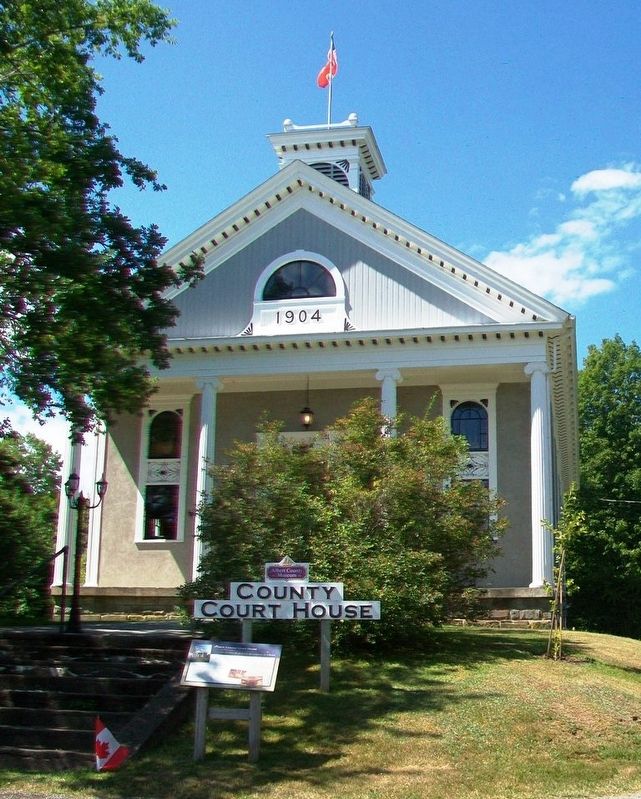
Designed by local architect Watson Reid, this magnificent Court House was built in 1904 partially on the same foundation as the original that was lost to fire earlier. The County Council reluctantly agreed to pay the whopping $4,495 price . . . — — Map (db m106750) HM
On Main Street (New Brunswick Route 114) at Old Great Road/Hopewell Cross Road, on the left when traveling north on Main Street.
An original Shiretown building where all real estate and some other legal transactions were recorded. The records also include County births, marriages and livestock identifiers.
À l'origine un édifice du chef-lieu du comté, les . . . — — Map (db m106646) HM
On Main Street (New Brunswick Route 114) at Old Great Road, on the right when traveling south on Main Street.
An original Shiretown building where County citizens made their remittances. The pressed tin interior is a Victorian era addition that contributes to the building's pleasant ambiance.
À l'origine un édifice du . . . — — Map (db m106705) HM
On Main Street (New Brunswick Route 114) at Hopewell Cross Road, on the right when traveling south on Main Street.
Viscount of Mickelham, Calgary and Hopewell
[Burgundy marker on monument]
Rt. Hon. Richard Bedford Bennett
1870-1947
Born at Hopewell Hill, New Brunswick, Bennett moved to Calgary in 1897. A member of the legislature of the North . . . — — Map (db m106707) HM
On King Street (New Brunswick Route 114) at Maple Street, on the right when traveling west on King Street.
A. R. McClelan was born in Riverside. At age twenty-three he entered politics and was elected to represent Albert County in the New Brunswick House of Assembly. He was a keen supporter of Confederation, and after Confederation in 1867 he became a . . . — — Map (db m106867) HM
On Chapel Street at Orange Street, on the right when traveling west on Chapel Street.
English: Built c1905 for R. Norman Loane, this four square Edwardian house was designed by the same architect who built St. James United Church. Two provincial premiers have lived in this house: J. K. Flemming (premier from 1911 to . . . — — Map (db m139195) HM
The Great Depression 1929-1941
The depression was world-wide. In the U.S., the banking system collapsed and 12.8 million people were unemployed. Hardest hit were youth, minorities, the elderly, and workers in the consumer durables industries. . . . — — Map (db m54783) HM
The Roosevelt Campobello International Park is a unique example of international cooperation - jointly administered, staffed, and funded by the peoples of Canada and the United States. Established by international treaty in 1964, the . . . — — Map (db m63591) HM
Near Rue Main (New Brunswick Route 134) north of Queen Street, on the right when traveling north.
English: Shawn Michael Graham was born on February 22, 1968 in Rexton, New Brunswick. He is the eldest child of Alan Graham and Sharon Crothers, and his step-mother Connie Tramley. His family also includes wife Roxanne Reeves, PhD, . . . — — Map (db m150497) HM
Near Rue Principale (Route 115) south of Rue Edouard, on the left when traveling south.
Français: « Chances égales pour tous ». Avec cette phrase tout simple, Louis J. Robichaud a changé le cours de l’histoire de l’Acadie et du Nouveau-Brunswick. Il inscrit, pour tout citoyen, de quelque classe qu’il soit, la dignité . . . — — Map (db m151247) HM
Near Loggie Drive just north of Cunard Street, on the left when traveling north.
English:
From Newcastle paperboy to London press baron, Max Aitken was, in his time, one of the most powerful Canadians on the world's stage. A self-made millionaire, he worked his way into the limelight through a 50-year role in . . . — — Map (db m142230) HM
Near Lancaster Avenue, 0.2 kilometers east of Bridge Road (New Brunswick Route 100), on the left when traveling east.
English:
In 1741 Benedict Arnold was born in Connecticut to a prosperous family. Twice before he was 18 young Arnold ran away to join British forces fighting the French and Indian wars.
When the American revolution began . . . — — Map (db m141993) HM
Near Lancaster Avenue, 0.2 kilometers east of Bridge Road (New Brunswick Route 100), on the left when traveling east.
English:
Born to a wealthy American family in 1736, Gabriel Ludlow grew up a supporter of the King. When the American Revolution came Ludlow raised a battalion for General DeLancey's Brigade. He was commissioned colonel of the . . . — — Map (db m141992) HM
Near Lancaster Avenue, 0.2 kilometers east of Bridge Road (New Brunswick Route 100), on the left when traveling east.
English:
At age 16 John Robertson left Scotland for Saint John to work as his uncle's clerk. From his arrival in 1817 Robertson's energy, vision and shrewd business sense were combined with significant social skills. People liked . . . — — Map (db m141994) HM
Near Lancaster Avenue, 0.2 kilometers east of Bridge Road (New Brunswick Route 100), on the left when traveling east.
English:
Born in 1818 at Gagetown, NB, Leonard Tilley apprenticed at age 13 to a pharmacist in the north end of Saint John known as Portland. As a certified pharmacist 7 years later, Tilley and his cousin opened "Peters and Tilley . . . — — Map (db m141997) HM
Near Woodlawn Road just east of Main Street (New Brunswick Route 106), on the left when traveling east.
English: These marks bear testimony to the ceremony when his Worship Mayor Jerome Bear on behalf of Dorchester Village Council granted Freedom of the Village of Dorchester to the Correctional Service of Canada on July 26th 2015. . . . — — Map (db m193198) HM
Near Woodlawn Road just east of Main Street (New Brunswick Route 106), on the left when traveling east.
English: Born at Shediac, educated locally, and called to the bar in 1847, Smith represented Westmorland in the New Brunswick Legislature from 1851 to 1867. Minister without portfolio in the first Liberal government of the province . . . — — Map (db m193194) HM
Near Main Street (New Brunswick Route 133) 0.7 kilometers east of Cornwall Road, on the right when traveling east.
English:
Daniel Lionel Hanington was born on 27 June 1835 in Shediac, New Brunswick, to Daniel Hanington, Sr. and Margaret Peters. He attended Mount Allison Academy, and then studied law under Charles Fisher in Fredericton. He was . . . — — Map (db m142004) HM
Near St. John Street south of Queen Street (New Brunswick Route 102), on the left when traveling south.
English:
Born in Fredericton, Fisher practised law before entering politics. Excepting the period 1850-1854 he represented York as a member of the Legislature continuously from 1837 until his retirement in 1868. Entering the . . . — — Map (db m139900) HM
Near St. John Street south of Queen Street (New Brunswick Route 102), on the left when traveling south.
English:
The Legislature of New Brunswick, recognizing the growing importance of health as a matter of public concern, established, in 1918, a department of government with specific and exclusive responsibilities in that field. . . . — — Map (db m139899) HM
Near Queen Street (New Brunswick Route 102) just east of St. John Street, on the left when traveling west.
English:
The Legislative Assembly Building, built in the Second Empire style with Corinthian features in 1882, together with the Old Education Building (1816, second story 1869) and the Departmental Building (1888), form the seat . . . — — Map (db m139856) HM
Near St. John Street south of Queen Street (New Brunswick Route 102), on the left when traveling south.
English:
Born in Sunbury County, educated at King’s College, and called to the bar in 1832, Wilmot entered politics as a reformer and represented York County in the Legislature (1835-51). A member of the Executive Council . . . — — Map (db m139897) HM
Near St. John Street south of Queen Street (New Brunswick Route 102), on the left when traveling south.
English:
Born in England, Douglas was Lieutenant-Governor and Commander in Chief of New Brunswick (1823-1831). He encouraged agriculture and fostered pioneer work in steam navigation and lighthouse construction. In 1828 he founded . . . — — Map (db m139898) HM