Lower Manhattan Today
The ever-growing Manhattan community is a dynamic mixture of businesses, residences, and cultural institutions of interest to visitors and residents alike.
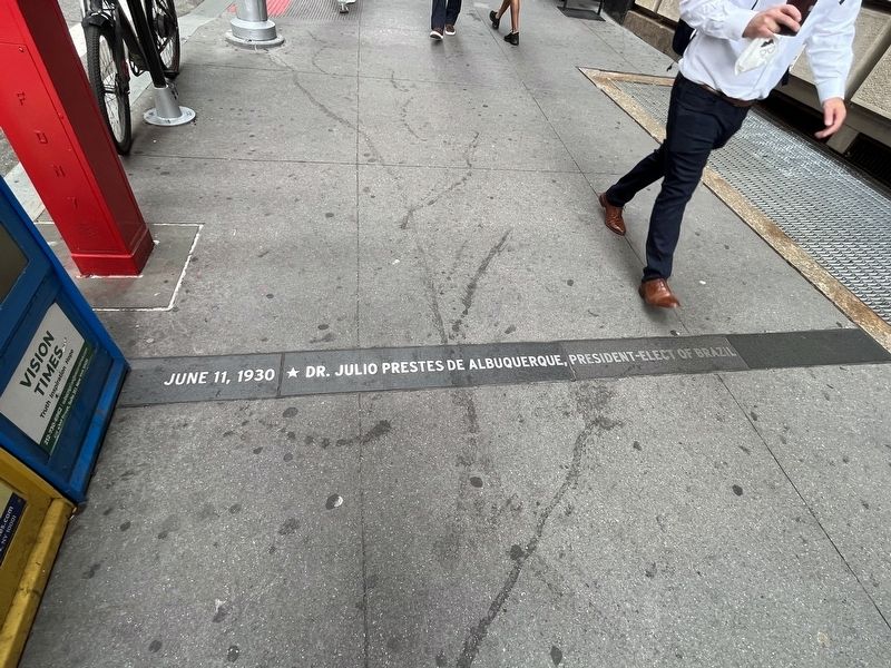
Destinations marked in a red dot indicate those points of interest . . . — — Map (db m131129) HM
Born, July, 1740. Marinus Willett. Died, Aug. 1830. Officer of New York Militia 1775-78. Sheriff of New York, 1784-92. Mayor of New York 1807-08. President of Electoral College, 1824. To commemorate the gallant and patriotic act of Marinus Willett . . . — — Map (db m147958) HM
Marquis Jacques de Dampierre and family, descendants of the Marquis de Lafayette, passengers on the maiden voyage of the French ocean liner Lafayette — — Map (db m183046) HM
Menatay, the Delaware word for Manhattan, was a gathering place for native people from across the region – a place linked by waterways and trails and abundant in natural resources.
“It all goes back to the Grandfathers, the people who were . . . — — Map (db m131211) HM
City of New York Borough of Manhattan Erected 1908-1909 by the Department of Docks & Ferries during the administration of George B. McClellan Mayor Herman A. Metz Comptroller Allen N. Spooner Commissioner Denis A. Judge Deputy Commissioner . . . — — Map (db m47369) HM
The museum embraces not only contemporary native cultures but also those known to us only through tradition. Here is a partial list of indigenous people from across the Western Hemisphere.
(This list includes the names of about 1200 tribes.) . . . — — Map (db m131246) HM
On the 22nd of April 1625 the Amsterdam Chamber of the West India Company decreed the establishment of Fort Amsterdam and the creation of ten adjoining farms. The purchase of the Island of Manhattan was accomplished in 1626. Thus was laid the . . . — — Map (db m13930) HM
This monumental flagstaff commemorates the Dutch establishment of New Amsterdam and the seventeenth century European settlement that launched the modern metropolis of New York City. Designed by Dutch sculptor H.A. van den Eijnde (1869-1939), the . . . — — Map (db m13927) HM
Under Peter Minuit, the settlers of the little city of New Amsterdam worked quickly. By about 1627 they had 30 wooden houses constructed along “The Strand”, facing the bluffed shore 500 yards across the water of what would soon be . . . — — Map (db m145643) HM
The Manhattanites were so focused on survival in the 1630s, that they might scarcely have noticed the changes. More sails appeared in the harbor bringing varied faces. Ebony faces from the highlands of Angola. Arab faces. An Italian, a Pole, a . . . — — Map (db m145645) HM
There was an actual deed for the sale of Manhattan but it vanished long ago. Fortunately, a Dutch official was on the dock in Amsterdam in 1626 when a ship from Manhattan arrived. The letter he wrote to his superior is, in effect, New York City’s . . . — — Map (db m145639) HM
Every reader of history knows the story: Peter Minuit bought Manhattan Island in 1626 from a group of Indians for 60 guilders worth of goods, or as a 19th century historian calculated it, 24 dollars. Of the thousands of transactions in which . . . — — Map (db m145642) HM
The English took over the Dutch colony in 1664, and New Amsterdam became New York. But the Dutch roots still thrive. Peter Minuit and his compatriots set Manhattan on course as a melting pot and business hub. The settlers weren’t motivated by . . . — — Map (db m128240) HM
By tens and twenties the settlers came in 1624 and 1625, pitching on the inhuman waves in frightfully vulnerable wooden ships. Two months it took to follow in the wake of the English explorer Henry Hudson, three if the winds failed. Hudson has . . . — — Map (db m145641) HM
As the settlers explored their island, they found it was wondrously varied: high hills, charging streams, ponds, stands of chestnut, poplar and pine. A brook flowed from the highlands in the area of 59th street and Fifth Avenue, about where the . . . — — Map (db m145644) HM
Peter Minuit arrived at a colony in turmoil. Some 150 miles upriver from the harbor, several Dutch soldiers were killed by Mohawk Indians. The settlers panicked. In 1626, they found their leader, Verhulst, guilty of mismanagement, removed him . . . — — Map (db m145640) HM
He had grown up speaking German, but his ancestry was French, so his name was pronounced in the French wat – Min-wee. He had no military training, but he was an individualistic, take-charge sort who would alter the course of history by . . . — — Map (db m127913) HM
This 1960s American office building has been ripped apart and rewired with a 21st-century communications infrastructure that can instantly connect its tenants with sites around the world. Famous in the 1980s as the high finance offices of . . . — — Map (db m127673) HM
New York Unearthed The underground chambers of “New York Unearthed,” a museum operated by the South Street Seaport Museum, display the remarkable extent of archaeological finds in New York. These range from the surprisingly old-3,000-year-old . . . — — Map (db m19715) HM
New York is a city of straight lines – it’s the very rare building that curves. The rectory of the Shrine of St. Elizabeth Seton occupies one of them: the elegant house built in 1793 for one James Watson, with an 1806 addition whose portico curves . . . — — Map (db m242678) HM
Pairs of peregrine falcons have been found nesting on the window ledges of such buildings as the Metropolitan Life Building, adjacent to this parkland. The reemergence of the peregrine falcon (Falco peregrinus) in North America is one of the . . . — — Map (db m127118)
PETRUS STUYVESANT'S GREAT HOUSE Location: Whitehall Street between Pearl & State Streets Dutch Name: Opt Waeter Near this site stood the “Great House” of Petrus Stuyvesant (c. 1612-1672), Nieuw Nederland’s last director. A . . . — — Map (db m127311) HM
Completed in 1907, the US Customs House was built when the United States was becoming an economic world power – and the Port of New York one of the most prosperous trade centers. Duties extracted by the United States Customs Service . . . — — Map (db m131209) HM
To the Glory of God.
------------------------
Under the direction of
General William Booth,
the founder of the Salvation Army,
Commissioner George S. Railton and seven women
officers unfurled the flag of the Salvation Army . . . — — Map (db m29388) HM
Olin J. Stephens, Jr, and the crew of the Dorade, winners of a Transatlantic yacht race from Newport, Rhode Island to Plymouth, England — — Map (db m209625) HM
Sharing the Circle
The approximately one million objects in the National Museum of the American Indian (NMAI) collection were amassed by George Gustav Heye (1874-1957). The collection spans the Western Hemisphere from the Arctic to Tiera del . . . — — Map (db m131245) HM
STADT HUYS (CITY HALL) Location: Broad Street & Coenties Alley Dutch Name: Langs Straet (Along the Shore) New York’s first city government began meeting across the street in 1653, after the Dutch West India Company agreed to grant . . . — — Map (db m127523) HM
We were very tired, we were very merry—
We had gone back and forth all night on the ferry.
It was bare and bright, and smelled like a stable—
But we looked into a fire, we leaned across a table,
We lay on a hill-top underneath . . . — — Map (db m132035) HM
The Stone Street Historic District consists of fifteen buildings on narrow, winding streets originally laid out by Dutch colonists. The district is characterized by a rare surviving cluster of commercial structures built after the Great Fire of . . . — — Map (db m168983) HM
Stone Street Historic District The cluster of buildings along winding Stone, South William, and Pearl Streets and Coenties Alley forms one of Downtown’s last oases of early 19th-century New York. Stone Street’s stores and lofts were built for . . . — — Map (db m127710) HM
The Archaeology of the Stadt Huys Block
The Excavation of the Stadt Huys Block
The first large scale archeological excavation in New York City was conducted on this block in 1979-80. The excavation yielded important cultural material from the . . . — — Map (db m127735) HM
The Cotton Exchange
Built in 1923 by the well-known architect Donn Barber, this building was revolutionary in many ways. Instead of placing the trading floor at street level, Barber placed it at the top. He canopied it with a large skylight and . . . — — Map (db m148715) HM
The former Downtown Athletic Club, built between 1929 and 1930, is one of Manhattan’s most distinctive art deco skyscrapers.
Designed by Starret & Van Vleck, the building is a rare example of a vertical clubhouse.
The irregular massing of the . . . — — Map (db m114685) HM
On this site stood the first Huguenot Church in New York City
Église Francaise du Saint-Espirit
1688-1704
The Reverend Pierre Peiret, founding pastor
Rededicated by the Huguenot Society of America
1991 — — Map (db m127333) HM
The US Custom House stands on the same ground as Fort Amsterdam, which was occupied by the Dutch in 1626 to secure their control for trade in the increasingly valuable harbor. At that time, the Dutch depended upon the native people – not . . . — — Map (db m131243) HM
Located within the shady recesses of New York's financial district, this garden was commissioned by the British Memorial Garden Trust and given to the City in memory of the British and Commonwealth citizens who lost their lives during the attacks . . . — — Map (db m209653) HM
New York is a city of straight lines – it’s the very rare building that curves. The rectory of the Shrine of St. Elizabeth Seton occupies one of them: the elegant house built in 1793 for one James Watson, with an 1806 addition whose portico curves . . . — — Map (db m242718) HM
For three decades, this sculpture stood in the plaza of the World Trade Center. Entitled “The Sphere,” it was conceived by artist Fritz Koenig as a symbol of world peace. It was damaged during the tragic events of September 11, 2001, but . . . — — Map (db m127125) HM
This Ancient Cannon was exhumed in 1892 on the site of No. 55 Broadway on the corner of Exchange Alley or the highway leading to the fortification called Oyster Pasty 1695-1783 Presented to the City of New York by William Henry Mairs --------------- . . . — — Map (db m135249) HM
Vietnam War Veterans Memorial All visitors, whether or not they are old enough to remember the Vietnam War, find this memorial a powerful experience. The simple 1985 granite and glass-block wall, 14 feet high by 70 feet long, is inscribed with . . . — — Map (db m128474) HM
Presented to the City of New York by the Conseil Provincial Du Hainaut in memory of the Walloon settlers who came over to America in the Nieu Nederland under the inspiration of Jesse de Forest of Avesnes then county of Hainaut, one of the XVII . . . — — Map (db m13924) HM
This structure, now the Roman Catholic Church of Our Lady of the Rosary, was designed by John McComb in Federal style and built about 1800 when many other mansions occupied this then fashionable thoroughfare. Of particular architectural interest is . . . — — Map (db m13772) HM
Watson House
7 State Street, Designed by John McComb, Jr., 1793.
Built for James Watson and his wife, Mary, the Federalist row house at 7 State Street was part of a residential district lined with fine brick townhouses belonging mostly to . . . — — Map (db m242483) HM
On September 11, 2001 two hijacked planes were flown into the two towers of the World Trade Center. As the towers collapsed, nearly 3,000 people were killed. Today, this site – less than a mile from where the towers once stood – serves . . . — — Map (db m47036) HM
Named in memory of
Major General Thomas H. Barry, D.S.M.
Commanding General at this Headquarters
1912, 1913, 1914 and 1919
Erected by The Military Order of the World Wars
New York Chapter — — Map (db m168340) HM WM
Named in memory of
2nd Lieutenant Cyril Carder, D.S.C.
D Co. 16th Infantry
Killed in action in France
July 21, 1918
Erected by
The Military Order of the World Wars
New York Chapter — — Map (db m168001) HM WM
[ Side 1 ] A Place Worth ProtectingThe same waterways that connected New York City to the world made it vulnerable to naval attack. During the Revolutionary War, a British maritime force captured New York. In the early days of . . . — — Map (db m47020) HM
Welcome to Castle Williams. This stone fort was built in 1811 to defend New York City against naval assault. The attack never came. Over the next two hundred years, the once state-of-the-art fort was re-used: as housing for army recruits, as a . . . — — Map (db m47039) HM
With walls forty feet high and eight feet thick, this red sandstone bastion bristled with over one hundred cannon when it was completed in 1811. Named after its designer, Lieutenant Colonel Jonathan Williams, it has also been nicknamed the . . . — — Map (db m149131) HM
For the children of Coast Guard men and women, Governors Island provided ample opportunities for school and for play. The youngest child could attend the Childhood Development Center, located in today’s historic district, or daycare in Castle . . . — — Map (db m167928) HM
Once known as Brick Row or Regimental Row and now as Colonels’ Row, the group of eight brick houses in front of you was built by the Army between 1893 and 1917. Although all were built to standard Army plans, slight variations over the years have . . . — — Map (db m47094) HM
This imposing residence is the Commanding Officer’s Quarters, also known as the Admiral’s House (after the most recent Coast Guard residents.) Built in the Greek revival style, it was completed in 1843. The house was designed by prominent New York . . . — — Map (db m47123) HM
Named in memory of
Lieutenant Colonel J.M Craig, D.S.C.
Headquarters, 16th Infantry
Killed in action in France
July 21, 1918
Erected by
The Military Order of the World Wars
New York Chapter — — Map (db m167964) HM WM
Named in honor of the 1st Division, U.S. Army Mexican War * Spanish American War Philippine Insurrection World War I * World War II Occupation of Germany — — Map (db m47065) HM
Beneath this site lie the remains of seven individuals believed to be early North American born colonists. The remains dated to the late Eighteenth to early Nineteenth Century were discovered approximately 100 feet Southwest of here during . . . — — Map (db m149134) HM
Ellis Island acted as an immigration station for the United States from 1892 to 1954. The 13.7 acre island is made up almost entirely of landfill, with the original island measuring only 3.3 acres. Prior to its expansion and its use as an . . . — — Map (db m167368) HM
The new Governors Island landfill was only just complete – a largely empty dust blown expanse of over 100 acres – when it gained fame for its role in the budding aviation industry. In 1909, the Hudson-Fulton Celebration took place to . . . — — Map (db m69794) HM
Constructed by the Phillipine (sic) American Society in cooperation with support Center New York Facilities Engineering Division and dedicated to the Governors Island community at the annual FilAm Barrio Fiesta on 29 July 1989 — — Map (db m167874) HM
This important example of military architecture is a dramatic reminder of the early defenses erected in New York Harbor to protect the City from invasion by sea. Like so many other early fortifications in this country, its star-shaped plan was . . . — — Map (db m47014) HM
Since the American Revolution, there have been three different fortifications at this location.
The first was hastily constructed in April 1776 when General George Washington ordered that earthen mounds and cannons be placed here to help protect . . . — — Map (db m168378) HM
Called by the Indians “Pagganck,” was purchased from two members of the Indian tribe of Manahatas named Carapetayne and Pehiwas by Wouter Van Twiller, a Governor and Director General of New Nether- land – June 16, 1637; The price . . . — — Map (db m47023) HM
Governors Island boasts a long military history and has played an important role in every major American military engagement since the Revolutionary War, including the War of 1812, the Civil War, World War I, World War II and the Gulf War. First . . . — — Map (db m47165) HM
This Greek revival style building was constructed in 1839 to serve as a post hospital. In its earliest configuration, the hospital consisted of two wards on the first floor and three smaller wards on the second. The basement contained offices, a . . . — — Map (db m47193) HM
The 2.2 mile road in front of you encircles the entire Island (sic). It was built in the early 20th century as a utilitarian road to get Army personnel around Governors Island. It was subsequently used by the Coast Guard for their personal and . . . — — Map (db m167247) HM
Before airplanes and missiles, the United States defended itself with fortifications along its coast and harbors. In this harbor a system of forts stood ready to protect New York; nearly a dozen were built before the War of 1812. Cannons in the . . . — — Map (db m47035) HM