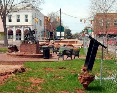
On Court Square (State Highway 20), on the right when traveling south.
The heart of Abbeville's Historic District is the magnificent tree-shaded Court Square. Located here is the replica of the original Confederate Monument erected in August, 1906 by the Daughters of the Confederacy, an old iron bell once used as . . . — — Map (db m12097) HM
On Greenville Street (State Highway 20) near Beltline Road (County Road S-1-35).
[Front]:
This cemetery, sometimes called Upper Long Cane Cemetery, dates from 1760. It includes the graves of some of the most prominent families of this area from the Colonial era to the present. The first marked grave is the field . . . — — Map (db m50740) HM
This town, established in 1823, grew up around a store owned by Matthew Young (1803-1876), who was also postmaster 1831-43. It was first called Pressly's Station, for the post office opened in 1823 with David Pressly (1764-1834) as postmaster. The . . . — — Map (db m9397) HM
On Greenville Street (State Highway 20) at Central Shiloh / Milford Dairy Road (State Highway S-1-100), on the left when traveling south on Greenville Street.
Erected by the descendants of Abraham Bowie, born in Scotland and settled in Durham Parish, Charles County, Maryland, about 1700 A.D. The family of his grandson Rhody Bowie, moved to Abbeville County, South Carolina about 1800. Eli Bowie, son of . . . — — Map (db m9338) HM
On Court Square (State Highway 28) south of Washington Street (State Highway 203), on the right when traveling north.
Abbeville's 6th courthouse - designed in beaux arts classical style by Edwards & Walter of Atlanta - dedicated in 1908 with City Hall/Opera House. (Two buildings indirectly financed by profits from Abbeville Dispensary, only one still operating . . . — — Map (db m14870) HM
On West Main Street (State Highway 184) north of Brooks Lane, on the left when traveling south.
Surveyed in 1762 by Patrick Calhoun and named for Gov. Thomas Boone, this 20,500-acre township was one of four townships laid out west of Ninety-Six as a buffer between white and Cherokee lands. In 1763 Scots-Irish families began to settle in the . . . — — Map (db m10605) HM
On North Main Street (State Highway 184) at College Street (State Highway 20), on the left when traveling south on North Main Street.
As early as 1765 the site 6 miles NW known to the Indians as Yellow Water, where the Keowee Path crossed the Cherokee line, was called DeWitt's Corner. In 1777 a treaty between S.C. and the Cherokee Indians was signed there. The present town was . . . — — Map (db m10602) HM
On Court Square (State Highway 20) north of West Pickens Street, on the right when traveling south.
Designed by S. Henry James to house first Bank of South Carolina in the Upstate (later became National Bank of Abbeville). One of oldest remaining buildings on the Square after a series of downtown fires in 1870s destroyed much of downtown.
Bank . . . — — Map (db m11918) HM
On Branch Road at State Highway 81, on the right when traveling north on Branch Road.
John De La Howe
Dr. John De La Howe, a French physician, came to South Carolina in 1764 and settled in the New Bordeaux community by the 1760s. His will left most of his estate, including Lethe Plantation, to the Agricultural Society of South . . . — — Map (db m9406) HM
On Calhoun Falls Highway (State Highway 72), on the right when traveling west.
Half mile southeast is Millwood, home of James Edward Calhoun, 1796-1898, son of John Ewing and Floride Bonneau Calhoun and brother-in-law of John C. Calhoun. After serving as lieutenant in the U.S. Navy, he developed Millwood, which ultimately . . . — — Map (db m9439) HM
On Camp Shop Road, on the right when traveling south.
Calhoun Falls State Recreation Area is located on Lake Russell, one of South Carolina's most popular and undeveloped large reservoirs. Lake Russell was created in 1984 and the 26,650-acre reservoir is surrounded by another 26,000 acres of public . . . — — Map (db m41448) HM
On Depot Street, on the left when traveling north.
Named after the city in France, Abbeville County has a rich historical and cultural heritage. The town of Abbeville, the county seat, is known for its quaint tree-lined square with bricked streets; the famous 1908 historic Opera House and its . . . — — Map (db m14843) HM
On York Street SE at Richland Avenue (U.S. 78), on the right when traveling north on York Street SE.
In Commemoration Of The
Founding Of Aiken County
on
March 10, 1871
Celebrating 125 years
County Commissioners:
Sen. C.D. Hayne, Rep. Gloster Holland,
Rep. William B. Jones, Rep. Sam J. Lee,
William Peel, Rep. Prince Rivers, . . . — — Map (db m34610) HM
Erskine College was founded in 1839 by the Associate Reformed Presbyterian Church as South Carolina's first four-year church-related college. The college grew out of an academy for men established in 1835 and seminary founded two years later at . . . — — Map (db m14793) HM
On Secession Avenue, on the left when traveling south.
One of the first organized mass meetings held here on November 22, 1860, to launch South Carolina's secession from the Union. Judge A.G. Magrath of Charleston, urged "immediate action on the part of South Carolina at any & every hazard", followed by . . . — — Map (db m11686) HM
Lethe Agricultural Seminary, founded 1797, was moved to this site in 1918 when it became a state school with the name changed to John De La Howe. A granite building with all facilities was built in sections from 1919 through 1925. Trustees . . . — — Map (db m9408) HM
Lethe Farm was a colonial and early federal period plantation owned by Dr. John de la Howe, founder of John de la Howe School. The farm was operated from about 1770 until 1806.
An archeological survey and limited test excavations were . . . — — Map (db m9411) HM
On SC Highway 184, on the right when traveling north.
The Donalds Grange No. 497 is significant for both its architecture and its contribution to the social development of the community and Abbeville County. For these reasons, Donalds Grange No. 497, Patrons of Husbandry, was entered into the . . . — — Map (db m12112) HM
In memory of the first person, a young girl whose name is unknown. Buried here about 1760. The story goes that she was visiting the Lesly family and died as a result of injuries sustained while they were making lye soap. John Lesly and his . . . — — Map (db m18756) HM
On State Highway 72 at Mt. Carmel Road (State Highway 823), on the left when traveling south on State Highway 72.
5.5 miles southeast is the burial ground of Patrick and Martha Caldwell Calhoun, Parents of John C. Calhoun; Deputy Surveyor 1756; First Representative from Up Country to Commons House of Assembly, 1769-1772; Member of First Provincial Congress, . . . — — Map (db m10627) HM
On North Church Street at Trinity Street, on the left when traveling north on North Church Street.
Trinity Episcopal Church is the oldest standing church in Abbeville. With its classic Gothic architecture and 125-foot steeple, it dominates the Abbeville skyline. Built by a congregation made prosperous by the economy of cotton in the antebellum . . . — — Map (db m11921) HM
On Court Square (State Highway 20), in the median.
South:
Ship's Anchor
1861-1865
"The world shall yet decide,
In truth's clear, far-off light,
That the soldiers who wore the gray, and died
With Lee were in the right!"
----------
"Brave men may die - right has no . . . — — Map (db m171618) WM
On North Main Street at Lane Street, on the left when traveling north on North Main Street.
This 1888 Queen Anne house was the home of Gen. Samuel McGowan (1819-1897) until his death. McGowan, a lawyer, Confederate general, and jurist born in Laurens Co., had moved to Abbeville in 1841. He was an officer during the Mexican War and in the . . . — — Map (db m21732) HM
On North Main Street, on the right when traveling south. Reported missing.
Queen Anne style Architecture Built in 1888
Once Owned by Confederate Gen. Samuel McGowan and by WWII Gen. W.E. Barksdale
Donated by J.D. Bundy in 1989 to the Abbeville County Historical Society
Now serves as Headquarters for the Society . . . — — Map (db m16129) HM
The establishment of John de la Howe School, the second oldest institution in the Carolinas, is one of the first examples of individual philanthropy that is found in the history of child-caring institution in the United States. The purpose of Dr. . . . — — Map (db m20887) HM
On Indian Mound Road east of Madden Road, on the right when traveling south.
This store, first known as Daniel’s store or the “Beehive,” was built before the Civil War by James Wright Daniel (1814-1904) and several business partners. In 1878 James Martin (1815-1879) bought the store from the other partners and became sole . . . — — Map (db m22966) HM
Less than a mile from this point, close to the Georgia shoreline of Lake Thurmond, lays the remains of Fort Charlotte now 50 feet under water. Named after the wife of King George III, Fort Charlotte was a British fort built in 1766. It was . . . — — Map (db m168566) HM
On Main Street (State Highway 81) at State Highway 33-91 on Main Street.
6.6 miles southwest are the ruins of Fort Charlotte, built of local stone, 1765-1767, to protect the French, British, and German settlements near Long Canes. Maj. James Mayson's seizure of it, defended by Capt. George Whitfield and Lieut. St. . . . — — Map (db m9185) HM
On Cedar Springs Road, on the right when traveling east.
[Front]:
This church was organized 1779-1780 by Dr. Thomas Clark (d. 1791), who had emigrated from Ireland to N.Y. in 1764. Clark moved to this area permanently about 1786, preaching here, at Long Cane (now Lower Long Cane), and at . . . — — Map (db m7184) HM
On Butler Church Road, on the right when traveling east.
At Butler Church, about one mile west, is the burial plot of the Butler family. Among the graves are those of William Butler, Captain in the American Revolution, United States Congressman, and Major General of S.C. Militia; Andrew Pickens Butler, . . . — — Map (db m81696) HM
On East Pickens Street, on the right when traveling west.
Opened August 1903 as $30,000 hotel "The Eureka" under management W.T. McFall. Built to cater to "drummers" of the textile trade with 30 rooms and 1 public bath. Banquet rooms used to show their wares while Curtain Call Lounge was a barber shop. . . . — — Map (db m7169) HM
On Henry M. Turner Street at Secession Avenue, on the left when traveling south on Henry M. Turner Street.
Historical Bicentennial marker
in memory of
Henry McNeal Turner
1834-1915
Birthplace: Newberry, South Carolina - Boyhood home: Abbeville, South Carolina
Missionary Pioneer to South Africa, Liberation Theologian, Social and Political . . . — — Map (db m20249) HM
On North Main Street (State Highway 28) at Wardlaw Street, on the left when traveling north on North Main Street.
The Greek Revival residence of Thomas Chiles Perrin (1805-1878), prominent Abbeville District lawyer, planter, businessman, and politician, stood here from 1858 until it burned in 1877. When completed the house was described as "one of the finest . . . — — Map (db m9358) HM
Southwest Side:
Founder
of the
Due West Female College
and for near twenty two years
its
President
1859-1881
Northeast Side:
Erected
By the Alumnae and
affectionately inscribed
to the Memory of . . . — — Map (db m15790) HM
On Russell Dam Overlook Road (State Highway 1-269), on the right when traveling south.
On the upper Savannah River near Elberton, Ga., and Calhoun Falls, S.C. lies the Richard B. Russell Dam and Lake -- authorized for construction by the Flood Control Act of 1966 for the purposes of hydropower generation, recreation and flood . . . — — Map (db m15876) HM
On Court Square (State Highway 202), on the right when traveling north.
The Lynching of Anthony Crawford. In Abbeville on Saturday, October 21, 1916, a white mob lynched a black leader named Anthony Crawford for cursing a white man. A 56-year-old planter, "Grandpa" Crawford owned 427 acres of land, had 13 . . . — — Map (db m101841) HM
On State Highway 184, on the right when traveling north.
The last action of the Revolution in this part of S.C. was at Pratt's Mill, a grist mill on the Little River owned by Joseph Pratt. On October 30, 1781, an outpost of 30 Patriots at the mill, under Capt. John Norwood, was surprised by 30 . . . — — Map (db m20821) HM
On Marshall Avenue, on the right when traveling west.
Drowned
April 4, 1920
East Inscription
Robert Manning
June 12, 1900
Inez Manning
May 23, 1897
Annie L. Manning
March 18, 1904
Alice Bradshaw
Dec. 20, 1907
Lucy Bradshaw
March 14, 1903
West Inscription
W. Lester . . . — — Map (db m57903) HM
Born August 29, 1852
Died February 26, 1905
----------
Founder and President
Orr Cotton Mills
----------
Honest and Fearless in the
Discharge of Every Duty.
Rest in Peace. — — Map (db m15269) HM
On Cokesbury Road (State Highway 254), on the left when traveling east.
[Original Marker]
Site of Old Tabernacle Methodist Church. Buried here are Confederate Generals Martin Witherspoon Gary, Nathan George Evans and other Confederate officers and soldiers.
[Second Marker]
1000 feet east is . . . — — Map (db m11095) HM
On North Main Street (State Highway 71) at Greenville Street (State Highway 20) on North Main Street.
Burt-Stark House When Jefferson Davis, President of the Confederacy, left Richmond after its fall in April 1865, he traveled south, trying to reach and rally the remnants of his army. On May 2, he spent the night at the home of Col. Armistead . . . — — Map (db m10564) HM
On West Main Street (State Highway 184) south of Austin Road, on the right when traveling south.
Dedicated to
Jane Byrd Wilson
Sept. 19,1939 - March 17, 2000
She worked to preserve the valuable
heritage of the Boonesborough Township — — Map (db m12103) HM
Near Stumphouse Tunnel Road near State Highway 28, on the right when traveling west.
[Listed from north to south]
Oconee Located on the edge of the Blue Ridge Mountains, Oconee County is known for nature-based activities such as boating, birding, backpacking, and camping
Pickens Pickens County has many beautiful . . . — — Map (db m185421) HM
On Laurens Street SW near The Alley, on the right when traveling north.
Aiken, chartered in 1835 and the county seat of Aiken County since its creation in 1871, was an early stop on the railroad line from Charleston to Hamburg. It was named for William Aiken (1779–1831), the first president of the S.C. Canal and . . . — — Map (db m9640) HM
Near Pendleton Street 0.1 miles south of West Main Street.
The man most responsible for opening up the northwestern part of South Carolina by driving out the Cherokee and the British, during and immediately following the American Revolution War, was General Andrew Pickens. deeply religious but a fierce . . . — — Map (db m20030) HM
On Frontage Road, on the right when traveling west.
Randolph Cemetery, founded in 1871, was one of the first black cemeteries in Columbia. It was named for Benjamin Franklin Randolph (1837-1868), a black state senator assassinated in 1868 near Hodges, in Abbeville County. Randolph, a . . . — — Map (db m29315) HM
On April 8, 1790, the Justices of the Peace for Pendleton County purchased this land to establish the courthouse town of Pendleton. Once Cherokee Indian land, the town became the judicial, social and commercial center for what now are Anderson, . . . — — Map (db m9614) HM
On Savannah River Scenic Byway (State Highway 28) at Barksdale Ferry Road (County Route S-33-61), on the left when traveling west on Savannah River Scenic Byway.
Badwell
Three miles west is the site of "Badwell," home of James Louis Petigru (1789-1863), leader of opposition to secession in South Carolina, outstanding Charleston lawyer, and S.C. Attorney General. He studied at Willington Academy under . . . — — Map (db m11456) HM
On Greenwood Highway (US 221), on the right when traveling south.
About 2½ miles southwest, a granite monument stands on the site of Rosemont, birthplace and home of Ann Pamela Cunningham, founder and first regent of the Mount Vernon Ladies' Association of the Union. Through her efforts Mount Vernon was . . . — — Map (db m74870) HM
This church, the first Associate Reformed Presbyterian congregation in what is now Anderson County, was organized about 1790 about 1 1/2 mi. SW of this site. Rev. Robert Irwin, its first regular minister, served from 1803 until his death in . . . — — Map (db m11747) HM
Thin black lines indicate changes in relevance. Between each pair of lines entries are ordered geographically but all have the same relevance.
* Inflectional forms of words are their plurals, singulars, and possessives as well as gramatical tenses and similar variations.