On Goodwill Road just north of Winston Lane, on the left when traveling north.
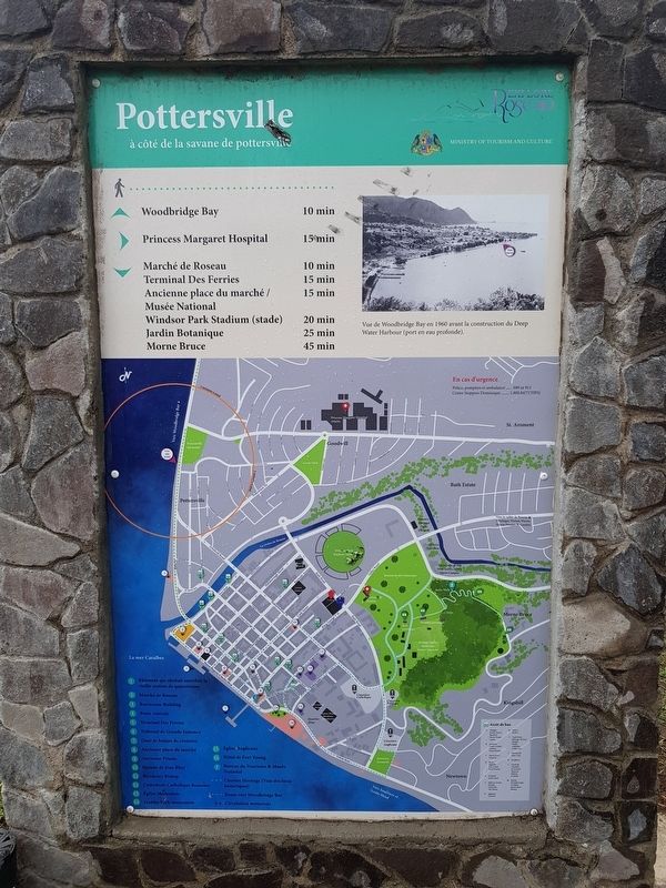
Pottersville By the Pottersville Savannah View of Woodbridge Bay in 1960 prior to the construction of the Deep Water Harbour. Walking distances to various historic sites and landmarks Map, key and emergency information . . . — — Map (db m135343) HM
On Victoria Street at Turkey Lane, on the right when traveling west on Victoria Street.
Anglican Church 1820 A permanent Anglican church was constructed on current site. British government funded the construction of the church for £6,500. It was built in the style of the Regency period which consists of a square, solid stone . . . — — Map (db m135310) HM
On Independence Street just east of Bath Street, on the right when traveling north.
David the Goliath The African Baobab Tree (Adansonia digitata) was blown down on the bus during Hurricane David on August 29th 1979. Fortunately the bus was empty at the time. The main stem is now more than 21 ft (6.4 m) in circumference and . . . — — Map (db m135318) HM
On Virgin Lane at Cross Street, on the right when traveling north on Virgin Lane.
Methodist Church
1787 • First Methodist missionary, Dr. Thomas Coke arrived.
It was originally a dwelling house.
1800 • The lot where the church is now was initially leased to Catholics who later converted to Wesleyan . . . — — Map (db m135311) HM
On Morne Bruce Road, on the left when traveling north.
Morne Bruce Garrison The Defence of Roseau Dominica was ceded to Britain by the Treaty of Paris in 1763. To keep the island under her rule, Britain had to defend it from the French. Some small forts were started in 1765. Military engineers . . . — — Map (db m135344) HM
Near Unnamed road just west of Morne Bruce Road, on the right when traveling north.
Morne Bruce Garrison North Point Battery Cannon and Signaling Station To get messages up and down the coast, Captain James Bruce organised a line of signal stations. The signals were a combination of gun salutes and flag signals. Each . . . — — Map (db m135345) HM
On Turkey Lane close to Victoria Street. Reported missing.
This monument is a symbol of freedom and emancipation. It is a tribute to all the enslaved Africans who suffered and were executed in the history of Dominica. It honours the Maroons who risked their lives to fight for the emancipation of all. It . . . — — Map (db m94220) HM
On Elliot Avenue at St. John's Avenue, on the left when traveling north on Elliot Avenue.
Pottersville Was once known as Ballahoo Town and then Lod bor – creole for “the other side”. Was mainly occupied by fishermen, domestics and port workers who worked in Roseau. Pottersville was named after . . . — — Map (db m135316) HM
On Dame Mary Eugenia Charles Boulevard just west of Church Street, on the left when traveling west.
Roseau Cruise Ship Berth Left: The origins of our main streets are based on footpaths leading to and from the market and landing place at the old harbour. Where you now stand is the site of the old harbour. Below: View of Roseau . . . — — Map (db m135309) HM
On Dame Mary Eugenia Charles Boulevard at Drury Lane, on the left when traveling west on Dame Mary Eugenia Charles Boulevard.
Roseau Bayfront Ferry Terminal Roseau Bayfront 1900, at the time it was known as Bay Street. For many years the town was fronted by a wide beach but after a series of hurricanes, sea defence walls were built along the waterfront. . . . — — Map (db m135342) HM
On Virgin Lane just north of Cross Street, on the right when traveling north.
Roseau Cathedral 1730 First started as a 16 x 40 ft solid timber church. This was fashioned after the Kalinago Kabays, consisting of strong posts and woven palm leaves. It was constructed by French lumbermen and peasant farmers. The original . . . — — Map (db m135314) HM
On Princess Lane at Charles Avenue, on the left when traveling north on Princess Lane.
Simon Bolivar Born in Caracas 24th July 1783 Died in Santa Marta 17th December 1830 Liberator of Venezuela, Colombia, Ecuador and Peru Founder of Bolivia — — Map (db m117234) HM WM
On Edward Oliver Leblanc Highway just north of Charles Avenue, on the left when traveling north.
Woodbridge Bay 1777 Woodbridge Bay is named after William Woodbridge, who from 1777, was the owner of Goodwill Estate. 1925 Prior to the construction of the Deep Water Harbour, it was a popular bathing spot lined with private beach huts and a . . . — — Map (db m135259) HM
Dominica In memory of those from Dominica who gave their lives in the Great War 1914-1918 Capt. A. E. Anderson · Capt. C. M. Blandy · Major Geo. W. Carew · Capt. G. Carter · Capt. C. H. Hill · Lieut. H. T. S. Johns · Lieut. F. Johnson · Capt. R. . . . — — Map (db m93900) WM
On Maurice Bishop Memorial Highway just west of Dr. Grooms Road, on the left when traveling west.
This plaque expresses the gratitude of the Grenadian people to the forces from the United States of America and the Caribbean, especially those who sacrificed their lives in liberating Grenada on 25 October 1983. It was dedicated by President Ronald . . . — — Map (db m134953) WM
Near Richmond Hill just north of Creighton, on the right when traveling north.
Welcome to Fort Frederick – one of the few forts in the world which has never fired a shot in anger. It was built by the French, who had wrested the island from the British in 1779. The French realized that had such fortifications existed at the . . . — — Map (db m135228) HM
Near Richmond Hill just north of Creighton, on the right when traveling north.
In the Bowels of the Fort This fort has a maze of underground tunnels and passageways, plus an extensive waterworks system. Look at the size of the stones. These tunnels offered an easy means of underground communication, allowing soldiers . . . — — Map (db m135229) HM
On Monckton Street at Young Street, on the left when traveling north on Monckton Street.
While the museum’s structure is, indeed, an historic artifact, the museum’s collection offers a variety of objects emphasizing the island’s past. Relics from native Indian populations provide a glimpse into early history while flora and fauna . . . — — Map (db m135193) HM
On Wharf Road just west of Tanteen Road, on the right when traveling west.
This corner stone was laid by the President of the Grenada Seamen and Waterfront Workers’ Union Bro. Arthur Ramsay on the occasion of the 25th Anniversary of the Union on the 1st. May 1977. — — Map (db m135182) HM
On Market Hill just east of Grenville Street, on the left when traveling east.
Historic Sedan Chair Portico This portico is the actual front entrance of this building for sedan chairs. In the 19th century, during early British colonial rule in Grenada, the sedan chair was a major mode of transportation used by the free . . . — — Map (db m135206) HM
On H.A. Blaize Street just east of Bain Alley, on the right when traveling east.
Marryshow House This structure was once the home of T. Albert Marryshow, better known as The “Father of the Federation.” This West Indian statesman promoted the formation of one nation from all of the West Indies. Aside from its . . . — — Map (db m135227) HM
On Lagoon Road just east of Paddock Road, on the left when traveling north.
Port Louis (1650) Grenada’s First Town On June 20th 1650 the French colonist led by Du Parquet, Governor of Martinique landed in this area and set up the first town which was called Port Louis. Project by: Kids Learning Center Sponsored by: . . . — — Map (db m135180) HM
On Church Street at St. John's Street, on the right when traveling north on Church Street.
Roman Catholic Cathedral Located on Upper Church Street, this church reflects several dates of construction. The tower, constructed in 1818, is the oldest part of the building. The remaining portion was built in 1884 on the site of an 1804 . . . — — Map (db m135225) HM
On Market Hill just east of Grenville Street, on the left when traveling east.
Sedan Porches These porches were popular in the seventeenth and eighteenth centuries when sedan chairs were a form of transportation. The porches, open on two sides, would shelter passengers from bad weather when they were embarking or . . . — — Map (db m135205) HM
On Grand Etang Road just south of Young Street, on the left when traveling south.
St. Andrew’s Presbyterian Kirk Popularly known as the Scots’ Kirk, this structure sits at the end of the Church Street. It was constructed in 1831 with assistance from the Freemasons. Two features for which the church is well known are its . . . — — Map (db m135203) HM
Although not located on Church Street, this structure has the distinction of being the oldest original church building in St. George's parish. It was constructed in 1820 and is still in use today. This brick structure, with simple brick buttresses . . . — — Map (db m94081) HM
On Monckton Road just south of Young Street, on the left when traveling north.
Antilles Hotel This structure, one of Grenada’s oldest, is in part one of the former French military barracks constructed in 1704. From 1767 to 1880 the British used portions for a prison. Shortly after, the upper floors became the island’s . . . — — Map (db m135201) HM
In everlasting memory of Prime Minister Maurice Bishop Fitzroy Bain ∙ Norris Bain ∙ Evelyn Bullen ∙ Jacqueline Creft ∙ Keith Hayling ∙ Evelyn Maitland ∙ Unison Whiteman Andy Sebastian Alexander ∙ . . . — — Map (db m135186) HM WM
Near Richmond Hill just north of Creighton, on the right when traveling north.
Backwards Facing Forts The gun ports on this unique fort face inland, rather than to seaward from where an attack on the island would have been expected. This is because of the lesson learned by the British in 1779 when the French took the . . . — — Map (db m135230) HM
As St. George's University's first Vice Chancellor (1978 - 1988), Geoffrey H. Bourne established the academic credentials that the medical school maintains to this day. His drive to firmly shape the newly established medical school according to . . . — — Map (db m94504) HM
On Grenville Street at Higgenson Street, on the right when traveling east on Grenville Street.
Welcome to the Kingstown Methodist Church Methodism officially came to St. Vincent on the 9th of January, 1787, when British missionaries Rev. Thomas Coke, Rev. John Coke, William Warrener and William Hammet landed at the Kingstown Harbour. In . . . — — Map (db m135179) HM
The Carnegie Old Public Library building, established in 1909, is hereby declared a Protected National Heritage Site with effect from the 4th day of February 2009 under the provisions of the St. Vincent and the Grenadines National Trust (Amendment) . . . — — Map (db m82663) HM
Seal of St. Vincent and the Grenadines
To the Glory of God
and in memory of
the sons of Saint Vincent
who gave their lives
for King and Country
in the Great War
1914 – 1918
Roll of Honour
Officers, Non-Commissioned . . . — — Map (db m82658) WM