On Carnavon Street at McKenzie Street, on the left when traveling east on Carnavon Street.
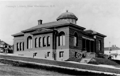
This plaque was unveiled on October 21, 2000 as part of the New Westminster Public Library's celebration of 135 years of service to the community. It commemorates the Carnegie Library which opened on March 5, 1905 on this site and continued to . . . — — Map (db m32130) HM
On Columbia Street at 4th Street on Columbia Street.
On September 10 & 11, 1898,
fire destroyed the
downtown portion of
the City. After the
conflagration only these two
major buildings in this area remained:
the Burr Block
and the Queens Hotel.
This marker is placed in
recognition . . . — — Map (db m32209) HM
The New Westminster Court House
The Court House was designed by architect George William Grant and opened on June 3, 1891 by the first colonial judge and Chief Justice for British Columbia, Sir Matthew Baillie Begbie.
On September 10, . . . — — Map (db m33185) HM
The Pacific Great Eastern Railway Station was built to service a rail link between North Vancouver westward along Howe Sound to the interior of the province. The foot of Lonsdale became a busy transportation hub in the early days of the community as . . . — — Map (db m31979) HM
On Esplanade West, 0.1 kilometers south of Mission Road, on the left when traveling south.
{In English:} The oldest surviving mission church in the Vancouver area has long been a focal point of the Mission Reserve. Chief Snat, a renowned Squamish leader, assisted by the Oblate missionaries, was largely responsible for building the . . . — — Map (db m32481) HM
Preparing the Land
When John Stewart acquired this land in 1880, only basic land clearing had occurred. The blackberry bushes and hardhack marsh provided hospitable habitat for birds and small animals, but was not suitable for successful . . . — — Map (db m61051) HM
Community Building
The first permanent structure in Elgin was the Elgin Hotel (1870). It was built as a convenient stop-over point for travellers between New Westminster and Blaine.
In 1875, four years before the incorporation of the . . . — — Map (db m60900) HM
River Routes
Located near the intersection of the King George VI Highway and the Nicomekl River, the Port Elgin area has been a crossroads for various forms of traffic for thousands of years. For centuries prior to the arrival of the first . . . — — Map (db m63715) HM
Settlement History
First Nations settlements and seasonal hunting and fishing camps existed at the mouths of rivers and along the coastal shoreline for thousands of years before Europeans reached the West Coast. These sites were near . . . — — Map (db m60901) HM
On 0 Avenue (Interstate 5), on the left when traveling south.
Upper marker:
This unfortified boundary line between the
Dominion of Canada
and the
United States of America
should quicken the remembrance of the more than century old friendship between these countries
A lesson of peace . . . — — Map (db m27450) HM
This trail was an ancient Indian travel-way linking tribal villages in the south to salmon grounds of the Fraser River.
The first white explorers, lead by Chief Trader James McMillan of the Hudson’s Bay Company passed here in December of 1824. . . . — — Map (db m60820) HM
A Trading Post on the Fraser
In 1824, James McMillan of the Hudson’s Bay Company and a party of forty-seven passed this shore on an exploratory trip from Fort George (Astoria) at the mouth of the Columbia River to the Fraser River. They . . . — — Map (db m61525) HM
On Powell Street at Carrall Street on Powell Street.
John Deighton was born in Hull, England. He was an adventurer, river boat pilot and captain, but best known for his "gassy" monologues as a saloonkeeper. His Deighton House Hotel, erected here on the first subdivided lot, burned in the Great . . . — — Map (db m40204) HM
On West Pender Street close to Hamilton Street, on the right when traveling east.
This building is an integral part of the Victory Square area dating back to 1929. The facade was renovated in 1948 by architect W.H. Birmingham. It was given Neo-classical treatments including a decorative cornice installed below the original . . . — — Map (db m54517) HM
On Beatty Street at Dunsmuir Street, on the right when traveling north on Beatty Street.
In 1878 on the approach of an enemy cruiser squadron these 64 pounder muzzle-loading naval guns were hastily shore mounted to protect Esquimault. Subsequently they were issued to No. 5 Battery B.C. Brigade of Garrison Artillery, the first citizen . . . — — Map (db m53894) HM
On Burrard Street at Nelson Street, on the right when traveling north on Burrard Street.
This landmark building, completed in 1957 as the head office for BC Electric Company, is a significant example of the Internationalist style of modern architecture. Floors are cantilevered from a central load bearing concrete core and supported by . . . — — Map (db m32348) HM
On West Pender Street near Hamilton Street, on the right when traveling east.
This small scale but well-executed example of Beaux-Arts classicism was designed by Thomas Hooper (the architect of Shaughnessy's Hycroft Mansion) and Elwood Watkins. Built in 1907 for Thomas Talton Langlois' BC Permanent Loan Company, after 1935 it . . . — — Map (db m54523) HM
On Granville Street close to West Hastings Street.
In the early 20th century, bank buildings were designed to recall classical temples and evoke a sense of permanence and dignity. The Neo-Classical design, imposing Ionic columns, decorative stonework, and prominent roof cornice of this building make . . . — — Map (db m33025) HM
This eclectic 1903 building was one of 2,507 public libraries paid for by the Scottish-American industrialist Andrew Carnegie, the richest person in the world when he retired in 1901. Carnegie believed in the "Gospel of Wealth" and gave away 90% of . . . — — Map (db m32318) HM
On West Pender Street at Carrall Street, on the right when traveling west on West Pender Street.
The Chi Kung Tong, later the Chinese Freemasons, purchased this building in 1907. It included meeting rooms, a male dormitory and a Chinese school - uses common to Chinese Society Buildings. The Chi Kung Tong assisted early immigrants from China who . . . — — Map (db m53798) HM
On Seymour Street just south of Dunsmuir Street, on the left when traveling north.
This unusual building is one of the few surviving Art Deco buildings in downtown Vancouver. Its roofline an exuberant crenelated cornice built in cast concrete and designed in a curvilinear waterfall theme. Downing is best known as the architect of . . . — — Map (db m41926) HM
On West Hastings Street at Cambie Street, on the right when traveling west on West Hastings Street.
This ornate Beaux-Arts skyscraper was commissioned by Imperial Trust in 1906 but opened in 1910 as the Dominion Trust Building after this company assumed the debt and completed construction. It was the tallest building in the British Empire at that . . . — — Map (db m54360) HM
On Beatty Street at Dunsmuir Street, on the right when traveling north on Beatty Street.
This fortress-like building has served as the drill hall and armoury for the British Columbia Regiment since its opening by HRH the Duke of Cornwall and York in 1901. The solid building with three-foot thick walls, was constructed of Gabriola Island . . . — — Map (db m54225) HM
On Stanley Park Drive, on the right when traveling south.
This area was the site of a coast defence fort manned during WW II
1939-1945
by The Royal Canadian Artillery
Batteries
31st Heavy
58th Heavy
85th Heavy — — Map (db m54578) HM
On West Hastings Street at Cambie Street, on the right when traveling west on West Hastings Street.
Thomas Flack commissioned this landmark commercial building in 1898, following his return from a prosperous venture to the Klondike gold fields. Completed in 1900, it framed one of the city's most prominent intersections, facing the first provincial . . . — — Map (db m53619) HM
Here stood
Hamilton
First Land Commissioner
Canadian Pacific Railway
1885
in the silent solitude
of the primeval forest
He drove a wooden stake
in the earth and commenced
to measure an empty land
into the streets of . . . — — Map (db m40645) HM
On Granville Street at West Hastings Street, on the right when traveling north on Granville Street.
Since 1907, generations of Vancouverites have arranged downtown rendevous with one simple phrase - "meet you under the Birks clock!"
Erected as "a public convenience for the people of Vancouver", this stalwart timepiece has stood in front of . . . — — Map (db m32970) HM
Near Stanley Park Drive, 1 kilometer east of West Georgia Street.
This gun is a naval type twelve pound muzzle-loader. Cast in 1816 at Woolwich, England, it was brought to Vancouver around 1894. The crests of King George III and of the Earl of Mulgrave, Master General of Ordnance are on the barrel.
Gun . . . — — Map (db m33868) HM
On Granville Street just south of Robson Street, on the left when traveling north.
This rare example of an art deco exterior employing colourful terra cotta with Egyptian overtones was designed by the architects of Vancouver's city hall as part of a 1929 building renovation. The interior structure dates from built in 1888 for . . . — — Map (db m42010) HM
On Beatty Street at Dunsmuir Street, on the right when traveling north on Beatty Street.
Crew 5, Wt 30 tonnes, Speed 40 km/hr, armament - 57 mm main gun, 2 x 30 cal mg, in service 1941-1945.
The Ram tank was designed and built in Canada as part of Canada's contribution to the allied war effort in WW II. A total of 1949 Ram tanks . . . — — Map (db m54263) HM
On West Georgia Street just west of Richards Street, on the right when traveling west.
Built in 1929 for the brokerage firm S.W. Randall Company, this commercial building is a good example of the design of the city's downtown office development at the time of the Great Depression. The brick cladding is enriched by the terra cotta . . . — — Map (db m54834) HM
On East Hastings Street at Jackson Avenue, on the right when traveling east on East Hastings Street.
In 1922 Ferrera Court was the home of Vancouver tailor David Marks, where vaudeville comedian Benny Kubelsky met thirteen-year-old Sadie Marks. They dated in 1926 and married the next year. As Jack Benny and Mary Livingstone they often returned to . . . — — Map (db m46691) HM
On Beatty Street at Dunsmuir Street, on the right when traveling north on Beatty Street.
M4A3E8, Crew 5, Wt 32 tonnes, speed 48 km/hr armament - 76 mm main gun, 2 x 30 cal mg in service 1943-1970
On 8/9 August 1944, the British Columbia Regiment (Duke of Connaught's Own), then designated Canadian 28th Armoured Regiment, was commanded . . . — — Map (db m53942) HM
On Dunsmuir Street at Seymour Street, on the left when traveling west on Dunsmuir Street.
Of the turn-of-the century hotels built in the downtown area before World War I, this is the last one that has survived as a hotel. Noted architect W.T. Whiteway designed it in 1913. He was the architect of the Sun Tower, the original 1903 Woodard's . . . — — Map (db m41988) HM
Near Stanley Park Drive, 0.3 kilometers north of West Georgia Street.
The Vancouver Rowing Club was established in 1899 when the Burrard Inlet Rowing Club joined the Vancouver Boating Club. Throughout it's history the Vancouver Rowing Club has played an important part in the athletic and social life of Vancouver. This . . . — — Map (db m31941) HM