Pennsylvania, Newtown Heritage Walk Historical Markers
The Newtown Heritage Walk is a self-guided walking tour of 35 wayside markers at historically significant sites along State Street (Newtown Borough) and Sycamore Street (Newtown Township).
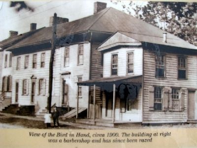
The Bird in Hand (formerly the "Red Lion Inn" and "Old Frame House") has played a rich and diverse role in the history of Newtown. There is record of a tavern on this site dating back to 1686, and it is considered the oldest frame structure still . . . — — Map (db m32278) HM
Prior to 1750, there existed a dwelling on this site, 1 East Washington Avenue, which had been built by Shadrach Walley, Newtown's first settler. Amos Strickland, a farmer and entrepreneur from Philadelphia, bought the property in 1760. In 1763, he . . . — — Map (db m32510) HM
Edward Hicks (1780-1849), son of Isaac and Catherine Hicks, was a Quaker minister, sign painter and folk artist, most famous for over sixty versions of his Peaceable Kingdom paintings. Born in Langhorne, his mother died when he was young, . . . — — Map (db m32316) HM
Newtown Friends Meeting is an active place of worship for approximately 250 area Quakers. Newtown Meeting was co-founded by Quaker minister, sign painter and folk artist Edward Hicks, now highly acclaimed for his renditions of The Peaceable . . . — — Map (db m32212) HM
The Half-Moon Inn (popularly known as the Court Inn) is located at 101-103 Court Street. The south portion of the Inn was the original one and one-half story frame cottage of Margaret and Joseph Thornton built in 1733 and later used as a tavern. . . . — — Map (db m32355) HM
The African American community has been a visible and important part of the community from the time Newtown was founded. During the first half of the 19th century, the Leedom Farm, Pine Grove Farm and the Archambault House were sites on the . . . — — Map (db m263660) HM
The buildings at 35 South State Street are situated on the tract of land on which the three main public buildings in Newtown were erected in 1726 when Newtown became the County Seat (Jail Keeper's House & Records Office, Jail, Court House). . . . — — Map (db m32428) HM
On April 16, 1838, the village of Newtown received its own municipal identity, distinct from that of Newtown Township, when it was formally chartered as a borough by the Pennsylvania Legislature.
In 1854, the Borough approved the plans to build . . . — — Map (db m32522) HM
The Newtown Cannery was located on the rear of the property at 451 South State Strees from 1903 to 1908 (see top photo). The Newtown Canning Company was a large operation where corn, tomatoes, apples, beans and pumpkins were canned and shipped to . . . — — Map (db m263563) HM
In 1684, William Penn planned his new town, which was later called Newtown. About 30 acres, on both sides of Newtown Creek, were reserved for common use. The town was designed to resemble an open fan of lots surrounding a narrow, rectangular town . . . — — Map (db m32609) HM
In 1824, the first Newtown area fire brigade was initiated as the Washington Fire Company. This organization was fortunate enough to purchase a hand-pumper, which was labeled "Old Washy" by its members. The Washington Fire Company was replaced by . . . — — Map (db m263659) HM
The third home of the Newtown Library Company is located at 114 East Centre Avenue at the corner of Centre Avenue and Congress Street. The Newtown Library Company was founded in 1760 and it is the third oldest private library in Pennsylvania. . . . — — Map (db m32354) HM
Newtown Theatre has an extensive history dating back to 1831, being the oldest movie theater in the United States, with the first movie being shown in 1906. Originally built to be a hall for town gatherings and a non sectarian church for traveling . . . — — Map (db m263613) HM
This area on North State Street has served as an important business hub for well over a century. Known far and wide, the annual spring carriage sale was held each year at J.V. and C. Randall's, located at 156 North State Street. James V. and William . . . — — Map (db m263655) HM
The Croasdale building, located at 2-4 South State Street, was built in 1853. This building was the center of Newtown's commercial activities, housing dry goods stores, the First National Bank and several lodges. During the Civil War, the front of . . . — — Map (db m32487) HM
St. Luke's Episcopal Church is located in the 100 block of Washington Avenue. St. Luke's was founded by Dr. Phineas Jenks, James Worth and William Paff in 1832. An effort was made to build an Episcopal Church in Newtown as early as 1766, but was . . . — — Map (db m263657) HM
Early records indicate that the A.M.E. Zion Church played an important role in the history of African Americans in Newtown. St. Mark African Methodist Episcopal Zion Church has historically been a source of fellowship and spiritual sustenance to . . . — — Map (db m263558) HM
Originally, the Newtown Hosiery Mill (a.k.a. The Stocking Works) operated out of this building at 301 South State Street. In 1884, the Excelsior Bobbin and Spool Works was founded by John B. Mawson in Yardley. In 1889, it was moved to Newtown after . . . — — Map (db m32246) HM
Although some historians believe there may have been a tavern at this location fifty years earlier, Andrew and Nancy McMinn built the first part of the Temperance House, located at 5 South State Street, circa 1772. Part of the building was used as . . . — — Map (db m32432) HM
The First National Bank and Trust Company of Newtown was first organized in 1864 and operated out of a room in the Paxson-Croasdale Building, located at 2-4 South State Street. By the spring of 1868, the bank bought property from the county and . . . — — Map (db m32612) HM
The recorded history of the Newtown Methodist Church begins in 1840, with a membership of twenty-two women and eleven men. It was part of a circuit served by an itinerant preacher. At the quarterly conference held at Pennsville on June 4, 1842, a . . . — — Map (db m263664) HM
The White Hall Hotel is located at 127 South State Street. Squire Isaac Hicks, father of Edward Hicks, lived in a frame house on this lot until 1836. During the Revolutionary War, the house was used as a store and was for a time occupied by the . . . — — Map (db m32281) HM
This building sits on land that was on the edge of the Newtown Common next to the original townstead land of Christopher Taylor. This property was originally purchased in 1796 by James Boyd “Minister of the Gospel” of the Presbyterian Church for . . . — — Map (db m28136) HM
The Newtown Commons was designed to be land shared by everyone in the Borough and Township. Unfortunately, because no one owned the land, no one took care of it. It appears that some people simply moved onto the land, built a house and lived there. . . . — — Map (db m29871) HM
Located at the corner of Sycamore Street and Swamp Road, the barn on this site was built in 1705 by the Buckman family, and rebuilt in 1901 after it was destroyed by fire. In the more recent past, the farm was known by locals as the Potato Farm or . . . — — Map (db m263584) HM
The Newtown and Wrightstown Turnpike (Durham) Toll House was in operation from approximately 1870 to 1920, when it was originally located at this site at the intersection of Sycamore Street (532) and Durham Road (413). The toll house served as the . . . — — Map (db m28132) HM
The Newtown and Wrightstown Turnpike (Durham) Toll House was in operation from approximately 1870 to 1920, when it was originally located at the intersection of Sycamore Street (532) and Durham Road (413). The toll house served as the headquarters . . . — — Map (db m263639) HM
The original structure on this property was likely built in about 1725 as the early settlers cabin of William Buckman. In 1918, John Goodnoe purchased the 78 acre farm located at 298 North Sycamore Street and started delivering produce grown from . . . — — Map (db m28133) HM
The McMasters House is located at 13 West Centre Avenue, on the corner of Sycamore Street and Centre Avenue. This building was built in about 1833 by John Bond and has been named after one of its early owners, Robert McMasters, a blacksmith who . . . — — Map (db m263581) HM
The Old Presbyterian Church was erected on North Sycamore Street in 1769 to replace the original 1734 log structure that stood a half mile to the west on Swamp Road near the high school and the bypass.
In 1776, George Washington used this church . . . — — Map (db m29836) HM
The opening of the railroad in 1878 brought many Catholic laborers to Newtown and prompted endeavors to accommodate them on Sundays. In 1880, a small group of Catholic families net together, obtained land and finally built their church at 135 South . . . — — Map (db m263612) HM
The lot on this site was first partitioned in 1796 from William Penn's Newtown Common. The original clapboard and brownstone structure was built in 1836. Over the years, this building has served at one time or another as a private residence, a jail, . . . — — Map (db m263662) HM
The land where this farmhouse sits was once part of a tract of 500 acres of land originally patented to Thomas Rowland that was bounded by Swamp Road, the Neshaminy Creek and Newtown Creek. This was one of the first patents granted in the area and . . . — — Map (db m263608) HM
During the Revolutionary War, General George Washington commanded America's Continental Army for several day from a brownstone located at this intersection of Swamp Road and Sycamore Street. The home was built by Benjamin Twining in 1757, who
later . . . — — Map (db m263582) HM
On March 4, 1681, Charles II granted William Penn a vast tract of land in the New World as payment for the debt the King owed Penn's father. The tract awarded to Penn included all of the land west of New Jersey, north of Maryland and south of New . . . — — Map (db m29833) HM