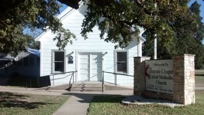
On Greenwood Drive at Houston Road, on the right when traveling east on Greenwood Drive.
Founded 1839, in the Republic of Texas by Rev. John Haynie (1789-1860). First church was of logs, and located a mile north, on land of Andrew Deavers Houston. This building, the third, was put up in 1907. Plaque erected by Houston . . . — — Map (db m79025) HM
On Central Avenue (U.S. 67/377) near Houston Street, on the right when traveling west.
A City-County Beautification Project sponsored by the Comanche County Bicentennial Committee featuring state historical markers and stone columns from 1890 county courthouse which were donated by the descendants of E.E. Anthony.
Park . . . — — Map (db m72303) HM
On Central Avenue (U.S. 67/277) at Houston Street, on the right when traveling west on Central Avenue.
One of boldest depredations in Texas history, made in May 1861, during the "Bright Moon." A braying mule wakened town after nearly all horses were stolen. Citizens spent rest of night molding bullets. Pursuit began at dawn, under command of . . . — — Map (db m72295) HM
On West Central Avenue (U.S. 377) at State Highway 36 on West Central Avenue.
James Colin Dingwall was born in Comanche County on November 8, 1907. The son of Scottish immigrants, his strong work ethic and natural engineering ability launched a career that took him from operating drag lines on the Trinity River levees in . . . — — Map (db m257116) HM
On North Texas Street (State Highway 16) at West LaSalle Street, on the left when traveling north on North Texas Street.
Railroad construction in Texas, interrupted by the Civil War and by the national economic depression of the early 1870s, began a period of recovery in the late 1870s and early 1880s. Chartered on May 31, 1879, the Texas Central Railway was owned . . . — — Map (db m161909) HM
John Wesley Hardin was one of the most notorious outlaws of the old west and Charlie Webb was a Brown County sheriff's deputy who was shot and killed by Hardin. Charlie Webb was a Texas Ranger and served Brown and San Saba Counties. In 1874 Webb had . . . — — Map (db m248265) HM
On Central Avenue (U.S. 67/377) at Houston Street, on the right when traveling west on Central Avenue.
Soon after the creation of Comanche County in 1856, the town of Cora (10 mi. SE) was platted to serve as the county seat. The courthouse in Cora, typical of many early Texas courthouses, was a 12' 7" x 12' 10", one-room, squared log structure. . . . — — Map (db m72304) HM
On Elm Pass Road at San Antonio Road (Farm to Market Road 480), on the left when traveling south on Elm Pass Road.
Lieutenant Nelson Orcelus Reynolds was a noted Texas Lawman, born in 1846 in Pennsylvania, Reynolds served in the Union Army during the Civil War. In 1874, he enlisted as a Texas Ranger in Blanco County. Reynolds captured the Horrell brothers and . . . — — Map (db m201964) HM
On W. Houston St. at N. Flores St., on the right when traveling west on W. Houston St..
(monument text) (1833-1903) Educator Attorney Public Servant Soldier Merchant Banker (plaque text): Thomas Claiborne Frost (1833 – 1903)
Born in Jackson County, Alabama in 1833, T. C. Frost graduated from Irving College . . . — — Map (db m63694) HM WM
A member of Stephen F. Austin's Colony, George Washington Gentry came to Texas in 1835 with his father and brother. Settling what is now Washington County, he worked as a farmer and surveyor. He participated in the Texas Revolution, several Indian . . . — — Map (db m158029) HM
On Central Avenue (U.S. 67/377) at Houston Street, on the right when traveling west on Central Avenue.
Born in Connecticut. Graduated at 19 from Yale. Studied medicine in France, where friends were Revolutionary War hero Lafayette and inventor Samuel F. B. Morse. As a North Carolina doctor he later took interest in politics and government.
Came . . . — — Map (db m72293) HM
On South Tarragona Street south of Church Street, on the right when traveling south.
Texas fugitive, John Wesley Hardin (1853-1895) was captured here on August 23, 1877. Hardin was wanted and dangerous, and his capture became national news that brought notoriety to Pensacola. Hardin had reportedly killed 27 men. He bragged he had . . . — — Map (db m91105) HM
On North Austin Street (State Highway 16) at West Central Avenue, on the left when traveling north on North Austin Street.
The Comanche emerged as a distinct group around 1680 when they broke off from the Shoshone People of Wyoming and acquired horses from the Pueblo Indians after the Pueblo revolt. They were so skillful in horsemanship that they had no equal. They . . . — — Map (db m158033) HM
On North Houston Street at West Central Street (State Highway 36), on the left when traveling north on North Houston Street.
The Comanche emerged as a distinct group around 1680 when they broke off from the Shoshone people of Wyoming and acquired horses from the Pueblo Indians after the Pueblo Revolt. They were so skillful in horsemanship that they had no equal. They were . . . — — Map (db m255619) HM
On Commerce Street at Main Plaza, on the left when traveling west on Commerce Street.
Thomas Claiborne Frost (1833-1903) came to Texas from Alabama in 1855 to teach at Austin College, Huntsville. Admitted to the Bar in 1856, he served as a Texas Ranger before setting up a law practice in Comanche County. He was a delegate to the . . . — — Map (db m30223) HM
On Central Avenue (U.S. 67/377) at Houston Street, on the right when traveling west on Central Avenue.
Robert Thomas Hill began life on August 11, 1858, in the aristocratic comforts of his parents' Nashville, Tennessee, home. His family, however, suffered tragic losses during the Civil War and by 1864 young Robert was an orphan living in his . . . — — Map (db m72292) HM
On 36th Division Memorial Highway (State Highway 36) just west of West Main Street, on the right when traveling west.
Founded 1854, as Troy. Later renamed in honor of a Miss Beeman of Bell County. In 1856 organization of Comanche County — then extending farther south and east than today's boundaries — Cora became county seat. A log cabin residence in . . . — — Map (db m162144) HM
On County Highway 108 0.5 miles north of 36th Division Memorial Highway (State Highway 36), on the right when traveling east.
A frontier settler from Monroe County, Virginia, Andrew Miller migrated to Texas while still a young man. In 1856 he settled in Comanche County near the Hamilton County line, he married Hannah Margaret Shockley in 1861. They had seven children. . . . — — Map (db m162206) HM
On Grand Avenue west of Houston Street, on the right when traveling west.
Army engineers laid out a military road in this area in 1850. By 1855 thirty to forty families had settled in the vicinity. Comanche County was created in 1856, and Comanche became the second county seat in 1859. Its citizens, who entertained . . . — — Map (db m72309) HM
On East College Avenue west of Cimarron Trail, on the right when traveling west.
Attorney and politician Newton R. Lindsey (1847-1908) constructed this home between 1881 and 1888. Born in Alabama, Lindsey served in the Confederate Army during the Civil War and attended college and law school before settling in Comanche County in . . . — — Map (db m257011) HM
On West Central Avenue west of South 9th Street, on the right when traveling west.
Surveyed in 1850 by Army engineers, this was the first wagon road to penetrate this area. Point of origin was San Antonio, site of U.S. Army District Headquarters after annexation of Texas in 1846.
This segment of road extended from Fort . . . — — Map (db m308381) HM
On North Austin Street (State Highway 16) at East Paine Avenue, on the right when traveling north on North Austin Street.
The earliest Episcopal worship services in the Comanche area were conducted in the late 1870s by Bishop Alexander C. Garrett of Dallas. In 1886, soon after the organization of the St. Matthews congregation, work began on this frame building. . . . — — Map (db m181867) HM
On S. Festival Lane 0.1 miles south of East Navarro Avenue, on the right when traveling south.
Soon after the Civil War and prior to the establishment of De
Leon, many families settled in this section of Comanche
County, together building a log schoolhouse on Austin
Branch. In 1876, thirteen settlers met at the log building at
the call . . . — — Map (db m310189) HM
On North Austin Street (State Highway 16) at West Grand Avenue, on the left when traveling north on North Austin Street.
John Wesley Hardin was not an outlaw; he was, however, a killer. It began with the accidental killing of an ex-slave during the time of one of the most corrupt administrations to ever occupy the governor's office, Hardin was 15 years old when the . . . — — Map (db m158040) HM
On Bryan Street near East Cedar Avenue, on the right when traveling north.
Reconfiguration of Comanche County by the State in 1858 led to a relocation of its county seat. In 1859 local land developer Captain John Duncan donated 200 acres here for a townsite to serve as Comanche County seat. Duncan's deed specified that . . . — — Map (db m158031) HM
On U.S. 377 at County Highway 317, on the right when traveling east on U.S. 377.
Began as "Cordwood Junction", siding on the Fort Worth & Rio Grande Railroad. Flatcars loaded wood here to be shipped over a wide area. As demand for the fuel increased, the railroad built a station house at site.
It was named in 1892 for O.H. . . . — — Map (db m184463) HM
Near Cox Cemetery Road 0.2 miles south of Farm to Market Road 589.
William Driscol Cox (1839-97) and his wife Amanda (Shugart) moved with their family from Tennessee to Texas in 1872. Cox taught in Robertson County then (1876) bought and moved to a 300-acre ranch at this site. He taught the first school in Sidney . . . — — Map (db m162130) HM
On Pecan Street 0.3 miles south of East Garfield Street (U.S. 277), on the right when traveling north.
Organized in 1885 from sections of Crockett, Kinney, and Pecos Counties, Val Verde County was named for a Civil War battle in New Mexico which involved Texas Confederate Forces. The growing railroad town of Del Rio was chosen as the seat of . . . — — Map (db m52678) HM
On Moorman Road at Hillcrest Street, on the left when traveling west on Moorman Road.
Born in Talladega, Alabama, in April 1842, Thomas Oscar (T.O.)
Moore was a civic leader in Comanche. After Moore's father's
business failed in 1854, the family moved to Texas, settling in
Hays County in 1855. By the fall of 1857, the family had . . . — — Map (db m220770) HM
On County Road 415 0.2 miles south of County Road 413, on the left when traveling south.
Zion Hill Baptist Church, organized on August 2, 1873, appointed Claiborne S. Fritts, Silas Puckett and P.D. Millican as its first Board of Trustees. On January 8, 1874, they accepted from Henry Martin a parcel of land for a church and cemetery. . . . — — Map (db m310196) HM
On 36th Division Memorial Highway (State Highway 36) at West Main Street, on the left when traveling east on 36th Division Memorial Highway.
Settlers began arriving in this area of Comanche County in the 1870s. Among the pioneers were members of the Blankenship family, who inherited land granted to brothers Christopher and A.K. Clark for Republic of Texas military service. The first . . . — — Map (db m162148) HM
On County Highway 157 0.4 miles east of Farm to Market Road 1689, on the left when traveling east.
Pioneer farmer and rancher William Pendergrass (1818-98) and his wife, Emaline (1819 -1907), moved from Tennessee to Smith County, Texas, in 1849. They first came to Comanche County in 1859, then settled here permanently after a brief return to . . . — — Map (db m162139) HM
Near East Austin Street at North Washington Street.
In proud remembrance of the achievements of her sons at Iwo Jima 1945, this memorial has been dedicated by the citizens of Comanche County, Texas.
Adams, Elbert H. USCG • Adcock, Leonard W. USMC • Almand, Allen O. USMM • Anderson, Henry A. . . . — — Map (db m211351) WM
On Farm to Market Road 1229 8.8 miles south of State Highway 350, on the right when traveling south.
Site given by John J. Handley (1842-1935), Confederate veteran who settled here in 1892, after living earlier in Georgia and in Smith and Comanche Counties, Texas. A farmer, he lived to see agriculture rival ranching.
Teville (named for "T" . . . — — Map (db m119703) HM
Thin black lines indicate changes in relevance. Between each pair of lines entries are ordered geographically but all have the same relevance.
* Inflectional forms of words are their plurals, singulars, and possessives as well as gramatical tenses and similar variations.