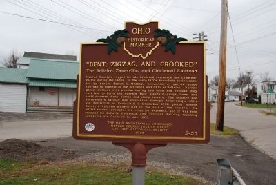
On Mill Street at East Marietta Street, on the right when traveling south on Mill Street.
side 1
While it served a vital role in the Monroe County life, by 1886 the BZ&C had defaulted on its construction bonds and entered the first of many receiverships. Its 300 trestles and bridges were expensive to maintain; frequent . . . — — Map (db m79266) HM
On East Church Street 0.1 miles west of Eastern Avenue, on the left when traveling west.
Side A
Sad Sam Jones
1892-1966
With 229 victories, Woodsfield's Samuel Pond Jones, or Sad Sam Jones, was one of professional baseball's top pitchers in the early 1900s. He started his 22-year career with the Cleveland Indians in 1914 . . . — — Map (db m79267) HM
The Sistersville Ferry is the longest continuously working mode of transportation in Monroe County, operating from 1815 to 2003. It crosses the Ohio River between Fly, Ohio, and Sistersville, West Virginia, which is the apex of the longest straight . . . — — Map (db m79270) HM
On South Dixie Highway 0.1 miles north of East Temperance Road, on the right when traveling south. Reported missing.
Michigan troops made heir headquarters here during the bloodless Toledo "war" in 1835.
Intense rivalry between the settlers of the two states fanned a controversy near flame. Original U. S. surveys had put in Monroe County the mouth of the . . . — — Map (db m268205) HM
On Erie Road at South Dixie Highway (Michigan Route 125), on the right when traveling east on Erie Road.
Michigan troops made heir headquarters here during the bloodless Toledo "war" in 1835.
Intense rivalry between the settlers of the two states fanned a controversy near flame. Original U. S. surveys had put in Monroe County the mouth of the . . . — — Map (db m277283) HM
On 3rd Street (Ohio Route 60) at Washington Street ( Route 7), on the right when traveling south on 3rd Street.
Side A
Richardson was born on May 25, 1824 in Washington County, PA. He graduated from Washington College in 1844 and moved to Ohio to be a teacher. In 1846 he enlisted In the Third Ohio Infantry and served in the Mexican War. He was . . . — — Map (db m143587) HM
On Broad Street east of Sunshine Avenue, on the left when traveling east.
A tribute to Gold Star Families and Relatives who sacrificed a Loved One for our Freedom.
Homeland • Family • Patriot • Grace To Those Who Gave • Sacrifice
Gold Star Families Memorial Monument
This monument honors, recognizes, and serves . . . — — Map (db m247653) WM
On East First Street at Washington Street on East First Street.
Monroe County was established in July, 1817, as one of the first steps in the organization of Michigan Territory after the War of 1812.
Then the old settlement of Frenchtown which centered upon this square took the name of Monroe and became the . . . — — Map (db m27634) HM
On North Main Street, on the right when traveling south.
In recognition of the patriotism of the people of Monroe County who oversubscribed their War Saving Quota in 1918 this tablet is gratefully erected by the Ohio War Savings Committee — — Map (db m209938) WM
Near 4th Street 0 miles south of Market Street, on the right when traveling north. Reported permanently removed.
The Lodge of Amity, one of the six founding lodges of the Grand Lodge of Ohio, was chartered on June 24, 1805, and first met in the Benoni Pierce Hotel at the northeast corner of Main and Fifth Streets, Zanesville. This marker was erected in . . . — — Map (db m212234) HM
On North Lakeshore Drive south of State Park Road, on the left when traveling south.
Presettlement Times
The area of Michigan known as Monroe was one of our state's earliest settled regions. Its location at the mouth of the River Raisin was strategic to both Native Americans and to the first Europeans who . . . — — Map (db m201328) HM
Near Mulberry Street west of Watt Avenue, on the left when traveling west. Reported permanently removed.
This small, backyard cigar company operated from 1900 to 1943. Mr. Roby's hand-made stogies or cigars were made here in this building by family members, with the help of 2 or 3 employees daily. It was located in Belmont, Ohio.
This shop has . . . — — Map (db m271561) HM
On North State Street (Ohio Route 3) at East Main Street, on the right when traveling north on North State Street.
From 1941 to 1967, Isaly's Dairy Store occupied this structure which
had an Art Deco influenced design. Isaly's was one of the first chain
businesses to come to Uptown.
The Isaly family, Swiss immigrants who settled in Monroe County,
Ohio, . . . — — Map (db m247891) HM
On North Main Street south of First Street, on the left when traveling south.
The Moore family left a distinguished mark on Waterloo's history.
Some time after settlement at Bellefontaine had been made, Captain James Moore, having established to some degree amicable relations with the Indians, took steps toward . . . — — Map (db m219950) HM
On South Custer Road near South Raisinville Road, on the right when traveling west.
As delegate from Monroe County to the convention which wrote Michigan's first constitution in 1835, Mr. Ellis won credit for the clause which earmarks penal fines for the support of libraries. It is this clause which has brought efficient rural . . . — — Map (db m171067) HM
On Ballengee Street at 1st Avenue on Ballengee Street.
On February 27, 1871, Summers County was formed from parts of Fayette, Greenbrier, Mercer, and Monroe counties. Summers County was named for George W. Summers, a prominent jurist and legislator from Virginia then West Virginia. Summers County was . . . — — Map (db m243866) HM
On Celina Road (Kentucky Route 61) 0.4 miles north of Cold Springs Road, on the right when traveling south.
During late June 1863 Confederate Gen. John Hunt Morgan's scouts and portions of his nine regiments moved into Cumberland County preparing for the Great Raid in Kentucky, Indiana, and Ohio.
The 1st Brigade, numbering 1,450 cavalrymen under Col. . . . — — Map (db m98882) HM
On North Main Street just south of First Street, on the left when traveling south.
The first roads through the town of Waterloo were Indian trails created by buffalo going from one hole to another. The first trails were made for foot travel and horses traveling in single file. trails were later widened by the use of axes and . . . — — Map (db m220257) HM
On the B-Line Trail north of W. Hillside Drive, on the left when traveling north.
The railroad, with the switchyard at its center, connected an expanding Bloomington to new markets.
In 1853, the first railroad line reached Bloomington from the south. The New Albany and Salem originated in New Albany, Indiana. . . . — — Map (db m244784) HM
Beallsville/Monroe County Honors Vietnam War Casualities
With a population of 475 residents, the Beallsville community gained the unfortunate distinction of having suffered the highest known per-capita casualty rate during the Vietnam War. . . . — — Map (db m79264) HM WM
On N. Custer Road, on the right when traveling north.
In memory of all Korean War Veterans
They told us, "We are going to have peace even if we have to fight for it.” So we fought in the mountains on Heartbreak Ridge and waded ashore at Inchon.
We froze in the winter and baked in the summer . . . — — Map (db m201666) WM
On Koontz Road (U.S. 219) at County Route 10/5, on the left when traveling south on Koontz Road. Reported missing.
Opened as a resort in 1820. Main building erected about 1823. Martin Van Buren, Clay, and Calhoun among prominent guests. General Jenkins and other Confederate leaders made headquarters here during several campaign. — — Map (db m253410) HM
On West Virginia Route 3/12 0.2 miles east of Huston Road, on the right when traveling east.
Great Bend Tunnel Construction
Construction of the Great Bend Tunnel aka the Big Bend Tunnel
began on 10 January 1870, tracks were laid 9 September -
12 September, 1872, and final completion of the tunnel was
in early 1873. The C&O . . . — — Map (db m165177) HM
Thin black lines indicate changes in relevance. Between each pair of lines entries are ordered geographically but all have the same relevance.
* Inflectional forms of words are their plurals, singulars, and possessives as well as gramatical tenses and similar variations.