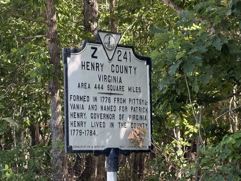
On Morehead Avenue (Virginia Route 87) south of Doyle Road (County Road 835), on the right when traveling north.
North Carolina. North Carolina was one of the original thirteen states. The first settlement was made on Roanoke Island, 1585, but was not permanent. Settlers from Virginia occupied the Albemarle region before 1663, in which year the colony . . . — — Map (db m304867) HM
Front Dedicated to soldiers and patriots of the American Revolution who are buried in IowaDecember 28, 1846 Iowa Our liberties we prize our rights we will maintainReverse George Perkins, N. and S. Carolina, Lee County William . . . — — Map (db m48277) HM
Near Virginia Avenue (Business U.S. 220) at Commonwealth Boulevard, on the right when traveling north. Reported unreadable.
As with other rail lines, the Dick & Willie made posssible for subsistence farmers in Appalachia to earn much-needed cash selling chestnuts to buyers in cities throughout the east. Early 20th century newspapers often showed train cars, overflowing . . . — — Map (db m205786) HM
Near Doyle Street at Hooker Street, on the left when traveling west.
The Dick & Willie was the first railroad to Henry County and was in full operation by 1884.
Originally, the railroad was a narrow gauge, but within a decade, the textile mills in the hamlets of present-day Eden were thriving. The narrow gauge . . . — — Map (db m205813) HM
Near Fisher Street at Fishel Street ( Route 174), on the right when traveling east.
The Dick & Willie Railway linked the rural counties with the urban worlds of Martinsville and Danville in a new and exciting way. "Dick & Willie" was the popular name for the Danville & Western Railway. At a time when most travel was made by horse, . . . — — Map (db m205817) HM
Near Fisher Street at Fishel Street ( Route 174), on the right when traveling east.
Local historians remember that the train earned its nickname from two early train workers: Richard Hundley and William Martin. The Dick & Willie was vital to the people, communities and industries it linked together — a partner and an important . . . — — Map (db m205816) HM
Near Virginia Avenue (Business U.S. 220) at Commonwealth Boulevard, on the right when traveling north.
The Dick and Willie Trail is 4.5 miles in length and runs along a portion of the former Danville and Western Railroad track. Once part of the Norfolk Southern Railroad, the Danville and Western was affectionately nicknamed the "Dick and Willie." . . . — — Map (db m205783) HM
Near Doyle Street at Hooker Street, on the left when traveling west.
The Dick and Willie Trail is 4.5 miles in length and runs along a portion of the former Danville and Western Railroad track. Once part of the Norfolk Southern Railroad, the Danville and Western was affectionately nicknamed the "Dick and Willie." . . . — — Map (db m205814) HM
Near Fisher Street at Fishel Street, on the left when traveling east.
The Dick and Willie Trail is 4.5 miles in length and runs along a portion of the former Danville and Western Railroad track. Once part of the Norfolk Southern Railroad, the Danville and Western was affectionately nicknamed the "Dick and Willie." . . . — — Map (db m205815) HM
Near Stultz Road at Liberty Street ( Route 174), on the left when traveling west.
The Dick and Willie Trail is 4.5 miles in length and runs along a portion of the former Danville and Western Railroad track. Once part of the Norfolk Southern Railroad, the Danville and Western was affectionately nicknamed the "Dick and Willie." . . . — — Map (db m205799) HM
Near Stultz Road at Liberty Street ( Route 174), on the left when traveling west.
Southerners share a love of celebrations, particulary at the end of harvest time. During the fall the Dick & Willie ran special trains that transported local residents to the fairs held in Danville, Leaksville (now part of Eden, N.C.), Martinsville . . . — — Map (db m205791) HM
On U.S. 58 at Business U.S. 58, on the right when traveling east on U.S. 58.
Once located to the south was Leatherwood, the plantation of Patrick Henry, governor of Virginia and great orator of the American Revolution. Henry is especially famous for his “Liberty or Death” speech made in 1775 in Saint John’s Church in . . . — — Map (db m104505) HM
On Cemetery Street 0.1 miles west of Moss Street South, on the left when traveling west.
The Town of Martinsville chartered Oakwood Cemetery in 1883 and deeded it to the Martinsville Cemetery Association in 1887. Buried here are about 80 Confederates soldiers, at least one Union soldier, and veterans of World Wars I and II. Also . . . — — Map (db m172170) HM
On Jones Street (Virginia Route 457) at East Main Street, on the left when traveling north on Jones Street.
On March 24, 1865, Union Gen. George Stoneman led 6,000 cavalrymen from Tennessee into southwestern Virginia and western North Carolina to disrupt the Confederate supply line by destroying sections of the Virginia and Tennessee Railroad, . . . — — Map (db m66013) HM
Henry County. Located in the foothills of southern Virginia, Henry County is named for Patrick Henry (1736-1799), Revolutionary leader and governor of the Commonwealth of Virginia. Henry lived in the county from 1779 to 1784. The General . . . — — Map (db m58373) HM
Near Letcher Lane (Virginia Route 749) 0.5 miles west of Ararat Highway ( Route 773), on the left when traveling west.
William Letcher, the maternal great-grandfather of James Ewell Brown Stuart, was born about 1750 near Petersburg, Virginia. He was the second son of Giles Letcher of Goochland County, who was born in Ireland, and his wife, Hannah Hughes, who was of . . . — — Map (db m162905) HM
On Old Liberty Drive, on the right when traveling west.
This boulder marks the
landed estate of
Patrick Henry
where he lived from
1778 to 1784
Erected by the Patrick Henry Chapter
Daughters of the American Revolution
1922 — — Map (db m301181) HM
On Broad Street (State Road 38) at South Main Street, on the right when traveling east on Broad Street.
Henry County Courthouse 1869. The Henry County Courthouse, designed by architect Isaac Hodgson, replaced a courthouse that had burned in 1864. Featuring a mansard roof and a 110-foot clock tower, it is pictured on the inside covers of Ross . . . — — Map (db m200358) HM
On Main Street (Jefferson Davis Memorial Highway) at Norwood Street on Main Street (Jefferson Davis Memorial Highway).
First National Flag (Stars and Bars)
The first official flag of the confederacy was the Stars and Bars, and was reported to the provisional congress of the C.S. by the flag committee on March 4, 1861. It appears to have not had a recorded . . . — — Map (db m90441) HM
Near Letcher Lane (Virginia Route 749) at Ararat Highway ( Route 773), on the left when traveling west.
After the murder of William Letcher in 1780, the history of the fifteen-hundred-acre farm that would become the birthplace and boyhood home of James Ewell Brown Stuart is complex, in some instances vague and uncertain. Shortly after her husband's . . . — — Map (db m267763) HM
On Sutherlin Avenue south of Main Street ( Route 293), on the left when traveling north.
The Town of Chatham has served as the seat of Pittsylvania County government since 1777. It is rich in history with architecturally significant pre-Revolution, Federal, Victorian and post-Victorian houses. Brochures for self-guided walking . . . — — Map (db m171909) HM
On Riverside Drive at Fairystone Park Highway ( Route 57), on the right when traveling south on Riverside Drive.
Constructed in 1947-1948 in the town of Bassett in Henry County, Virginia, the school officially opened in 1949. It is an excellent example of a two-story Georgian-Revival style school built after World War II. It is the last school to be . . . — — Map (db m205768) HM
Near Franklin Street 0.1 miles north of Depot Street, on the right when traveling north.
A Rich Heritage in Textiles Began Just Across the Street
The building directly across from you, now known as the Clocktower Building, was once home to one of Martinsville's early textile mills—Martinsville Cotton Mill. Rucker & Whitten Plug . . . — — Map (db m205820) HM
On Abram Penn Highway (County Route 626) at Kootes Mill Road (County Route 703), on the left when traveling north on Abram Penn Highway. Reported permanently removed.
200 yards south is “Poplar Grove,” Penn’s old home and burial place. At age 21 he “won his spurs” leading a company under General Lewis at Point Pleasant. During 1780–81 he organized the first Revolutionary troops from Henry and adjoining counties, . . . — — Map (db m65815) HM
On Sago Road 0.5 miles north of Callands Road ( Route 57), on the right when traveling north.
You are facing what is believed to be the original courthouse of Pittsylvania County. Here, on January 26, 1775, county residents gathered to elect a Committee of Inspection (later redesignated Committee of Safety)— a momentous step toward . . . — — Map (db m299876) HM
On Lee Highway (U.S. 11) south of 2nd Avenue, on the right when traveling north.
The Carolina Road passed here on its route from Pennsylvania through the Valley of Virginia to the Carolina backcountry and beyond. Originally developed by Iroquois warriors, the road became a conduit for settlers of European descent, including . . . — — Map (db m298695) HM
On Virginia Avenue (U.S. 220) at Oak Forest Road ( Route 984), in the median on Virginia Avenue.
Franklin County. Area 697 Square Miles. Formed in 1785 from Henry and Bedford and added to from Patrick. Named for Benjamin Franklin. General Jubal A. Early lived in this county.
Henry County. Area 444 Square . . . — — Map (db m63193) HM
On A L Philpott Highway (U.S. 58) west of Turnpike Road, on the right when traveling west.
Henry County. Area 444 square miles. Formed in 1776 from Pittsylvania, Governor of Virginia. Henry lived in the county 1779-1784.
Patrick County. Area 485 square miles. Formed in 1790 from Henry, and . . . — — Map (db m290185) HM
On Koger Mill Road at Abram Penn Highway ( Route 626), on the left when traveling west on Koger Mill Road.
Just south of here is the site of Poplar Grove, home and burial place of Abram Penn, Revolutionary-era leader. Penn commanded a company during Dunmore's War against the Shawnee in 1774. The next year he was elected to the Pittsylvania County . . . — — Map (db m304868) HM
On Alabama Route 27 at County Road 7, on the right when traveling east on Alabama Route 27.
Cureton Bridge
Cureton Bridge was an old settlement named for the Cureton family who settled here in the early 1820's. The village was located on the East Fork of the Choctawhatchee River in western part of Henry County and Northeast of what . . . — — Map (db m164377) HM
On Greensboro Road (Business U.S. 220) at Joseph Martin Highway (County Route 685), on the left when traveling north on Greensboro Road.
Three miles southwest is Belleview, home of Major John Redd, a pioneer in this section. Redd served in the Indian Wars and in the Revolution, being present at the siege of Yorktown in 1781. — — Map (db m104510) HM
On Turkey Creek Road at Raymond Stotzer Frontage, on the left when traveling north on Turkey Creek Road.
The Brazos Valley was first settled and formed by people from all over America and other foreign lands. The earliest Anglo settlers arrived in this Mexican province from nearby southern states, lured by large Mexican land grants. After the Texas . . . — — Map (db m283311) HM
Near Wilderness Road (U.S. 58) at Baileytown Road (Virginia Route 690).
Revolutionary Soldier
Henry County VA
Cherokee Agent for
Continental Congress
Virginia and North Carolina
1777- 1789
Leader
Powell’s Valley Expedition
with his brother
Maj Brice Martin
Established Martin Station . . . — — Map (db m233525) HM WM
Near Price Lane 0.1 miles south of State Route 7/13, on the right when traveling south.
1836........................
Largest City in Henry County
Welcome to Clinton, the largest city in Henry County. The city is named for DeWitt Clinton, governor of New York (1817-23) and primary advocate for the Erie Canal. Henry . . . — — Map (db m252501) HM
On West Main Street (Virginia Route 293) at Mount Vernon Avenue, on the right when traveling east on West Main Street.
This house was built in 1891 as the home of Andrew Jackson “Jack” Montague, 1862-1937, Governor of Virginia, 1902-1906. During his residence in Danville, Mr. Montague established himself as a lawyer, U.S. District Attorney, orator, and political . . . — — Map (db m14474) HM
Thin black lines indicate changes in relevance. Between each pair of lines entries are ordered geographically but all have the same relevance.
* Inflectional forms of words are their plurals, singulars, and possessives as well as gramatical tenses and similar variations.