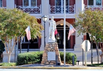
On Hancock Street at East Jefferson Street, on the right when traveling east on Hancock Street.
Erected by
Henry Walton Chapter
Daughters of the America Revolution
In memory of
The Boys From Morgan County, Georgia
Who fought in the World War
April 6, 1917 – November 11, 1918 — — Map (db m60788) WM
On Fairplay Street 0 miles north of West Dixie Highway, on the left when traveling north.
On the occasion of its Bicentennial, Morgan County placed this marker here to commemorate the community of
Rutledge
In the 1840s, the heirs of Hezekiah Rutledge deeded right-of-way to the Georgia Railroad. The farm came to be referred . . . — — Map (db m17303) HM
On Dixie Highway 1.3 miles west of Wilson Road, on the right when traveling east.
On the occasion of its Bicentennial, Morgan County placed this marker here to commemorate the community of
Dorsey As early as 1839, historic maps identify a community called Palestine in proximity to the community that became known as Dorsey. . . . — — Map (db m21914) HM
On Hancock Street at High Street, on the right when traveling north on Hancock Street.
Born Enslaved
December 25, 1803
Greene County, Georgia
Elected in 1868
from Morgan County to the
Georgia House of Representatives
Died December 5, 1878
Madison, Georgia
Additional marker
Georgia House of . . . — — Map (db m264111) HM
On West Washington Street (Georgia Route 83) 0 miles north of 5th Street, on the left when traveling north.
Madison first expanded northwest between the Madison Female Academy and the town spring, one branch of Tanyard Branch-so named for the tanning of animal hides on this site. The branch descends from the Main Street ridgeline and is paralleled by W. . . . — — Map (db m47982) HM
On Reese Road at Durden Road, on the right when traveling south on Reese Road.
On the occasion of its Bicentennial, Morgan County placed this marker here to commemorate the community of Reese
Originally, the community of Reese was known as Ebenezer, and it has been identified as a community that grew up along an old post . . . — — Map (db m19934) HM
On West Main Street 0.2 miles north of Parks Mill Road, on the left when traveling north.
On the occasion of its Bicentennial, Morgan County placed this marker here to commemorate the community of
Buckhead
One of the earliest settlements in Morgan County, the area around Buckhead was still in close proximity to Native . . . — — Map (db m16136) HM
On Swords Road 0 miles east of Blue Springs Road, on the left when traveling east.
On the occasion of its Bicentennial, Morgan County placed this marker here to commemorate the community of
Swords
Named in honor of the family who contributed substantially to the economic success of the community, Swords has its roots . . . — — Map (db m16236) HM
On County Route 33 at County Route 29, on the left when traveling south on County Route 33.
In 1835, pioneering families migrated from Morgan County, Georgia to Cherokee County, AL, settling in the Ambersonville area, later renamed Spring Garden. These families were members of Carmel Presbyterian Church in Morgan County and brought their . . . — — Map (db m132792) HM
On Godfrey Road at Antioch Church Road, on the left when traveling north on Godfrey Road.
On the occasion of its Bicentennial, Morgan County placed this marker here to commemorate the community of
Godfrey
The town of Godfrey was incorporated by the Georgia Legislature on July 25, 1906. However, this community has much older . . . — — Map (db m16176) HM
On Reinbach Street 0.1 miles south of North Railroad Street, on the left when traveling east.
Bourland Jolly (a.k.a. Boling Jolley) (1766-1844) born in Dinwiddie County, Virginia where he enlisted in the VA. Militia in 1781. He was enlisted by a Captain Connelly and later served under a Col. Lucas at the Siege of Yorktown. After . . . — — Map (db m292353) HM WM
On East Jefferson Street 0 miles east of Hancock Street, on the right when traveling west.
Establishment of Madison was part of a larger movement to settle the Georgia frontier and the westward population shift. The first division of town land created 48 original lots, each measuring 100 by 200 feet. Lots were sold on February 23, 1809, . . . — — Map (db m47477) HM
On Academy Street at Burnett Street, on the right when traveling west on Academy Street.
Georgia's General Assembly of 1865-1866 passed important property rights laws for its black population, most of whom had recently been emancipated. Blacks could legally buy, sell, inherit, and lease both land and personal property. The experience of . . . — — Map (db m20833) HM
On Wellington Street (Georgia Route 83) north of West Washington Street, on the left when traveling north.
Tanneries, dirty and smelly, were always erected on a water source on the outskirts of town. Such is likely the origin of the Richter Cottage, built c1830 along Tanyard Branch, which still flows about 200 feet behind the cottage.
It's about . . . — — Map (db m284168) HM
On Burney Street, on the right when traveling north.
In 1894, the Georgia Legislature empowered Madison to establish public schools, permitting Board of Education elections and noting "white and colored children shall be taught at separate schools." Overwhelmingly, citizens supported starting a . . . — — Map (db m266369) HM
On Lower Apalachee Road 0 miles east of Shockley Road, on the right when traveling east.
On the occasion of its Bicentennial, Morgan County places this Marker here to commemorate the community of Apalachee The name Apalachee is derived from the Indian Tribe that was part of the Creek Confederation, though there is no evidence that . . . — — Map (db m13418) HM
On Bostwick Road (Georgia Route 83) 0 miles west of 1st Street, on the right when traveling west.
On the occasion of its Bicentennial, Morgan County placed this marker here to commemorate the community of
Bostwick
Named in honor of the family who contributed substantially to the economic success of the community, Bostwick was . . . — — Map (db m16220) HM
On Parks Mill Road at Reids Ferry Road, on the right when traveling east on Parks Mill Road.
On the occasion of its Bicentennial, Morgan County placed this marker here to commemorate the community of
Park’s Mill
The construction of Park’s Mill is thought to be contemporary with the creation of Morgan County by act of the Georgia . . . — — Map (db m17274) HM
On Hard Labor Creek State Park Road 0.2 miles east of Knox Chapel Road, on the right when traveling east.
On the occasion of its Bicentennial, Morgan County placed this marker here to commemorate
Hard Labor Creek State Park
This park was built in 1934 by the Civilian Conservation Corps (CCC), a New Deal program sponsored by President . . . — — Map (db m17574) HM
On Barnett Avenue near John Quick Road, on the left when traveling west.
Colonel William E. Barber
United States Marine Corps
Commanding Officer, Company F, Second Battalion
Seventh Marines, First Marine Division
Awarded the Medal of Honor, Chosin Reservoir, Korea, from
28 November to 2 December, 1950 . . . — — Map (db m3114) WM
On Point Mallard Circle, on the right when traveling east.
Black Fox (c. 1746-1811) lived west of Decatur and east of Courtland near Fox's Creek, his namesake. A principal chief of the Cherokee who, under the treaty of Jan. 7, 1806, by which the Cherokee ceded nearly 7,000 sq. m. of their lands in . . . — — Map (db m280663) HM
Near Capitol Avenue Southwest south of M.L.K. Junior Drive Southeast, on the left when traveling north.
Expelled Because of Color” is dedicated to the memory of the 33 Black state legislators who were elected, yet expelled from the Georgia House because of their color in 1868.
The cinder block forms at the base of the sculpture symbolize the . . . — — Map (db m130191) HM
Thin black lines indicate changes in relevance. Between each pair of lines entries are ordered geographically but all have the same relevance.
* Inflectional forms of words are their plurals, singulars, and possessives as well as gramatical tenses and similar variations.