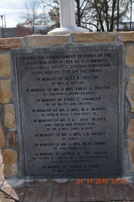
Established in 1976 as a community bicentennial project, this park is significant because it is both the final resting place for several early settlers and decision makers and it is one of the last undeveloped areas that was part of the State of . . . — — Map (db m221638) HM
On West Bruce Street west of Court Avenue, on the right when traveling west.
Because of its proximity to the rivers, Sevierville was vulnerable to devastating floods from its founding until the late 1960s. As if flooding wasn't enough, disastrous fires have also plagued the town.
The oldest record of a major flood was . . . — — Map (db m184570) HM
On Library Drive 0.2 miles north of Community Center Drive, on the right when traveling west.
Col. Samuel Wear built Fort Wear in this vicinity about 1781, the year that Cornwallis surrendered at Yorktown. Fort Wear was one of nearly a dozen forts built in the 1780s in Sevier County. Its blockhouse was made from sturdy hand-hewn logs and . . . — — Map (db m258265) HM
Near Old Mill Avenue at Old Mill Street, on the left when traveling west.
In the decades leading up to the bloody, four-year U.S. Civil War (1861-1865), the people and activities at The Old Mill embodied many of the conflicts of a divided nation.
The farmers who relied on the mill and other Pigeon Forge businesses . . . — — Map (db m276642) HM
On Old Mill Avenue west of Old Mill Street, on the right when traveling east.
When the Civil War began, Sevier County Unionists at first operated quietly in secessionist Tennessee. In 1861, they set up a secret garment factory in the second floor of this mill and made cloth for uniforms. They also made shoes for Federal . . . — — Map (db m65704) HM
On Park Road 0.1 miles west of McCarn Circle, on the right when traveling east.
In Memory of
Isaac Thomas
A soldier of the American Revolution, a trader with the Indians and scout to Kings Mountain, who carried the message of warning from Nancy Ward to the Watauga settlers, thus saving the lives of the Tennessee . . . — — Map (db m275001) HM
This churchyard is one of the oldest Baptist churchyards in Tennessee, (Established in 1789). It is the final resting place for many prominent pioneers. Deeded to the City of Sevierville by The First Baptist Church of Sevierville in 1975. It was . . . — — Map (db m17110) HM
On Library Drive west of Garland Harmon Drive, on the right when traveling west.
Colonel Samuel Wear -
Born 1753 Died - April 3, 1817 -
Pioneer -
Soldier of four wars -
Colonial, Revolution, Indian, 1812 -
One of the heroes of Kings Mountain and a founder of the State of Franklin — — Map (db m258263) HM WM
On Chestnut Hill Road (Tennessee Route 92) at Public Drive, on the right when traveling north on Chestnut Hill Road.
A Bridge Over Time
From 1942 to 1944, the Tennessee Valley Authority (TVA) designed and built a new State Route 92 bridge over the French Broad River and Douglas Reservoir at Dandridge. The two-lane bridge was impressive for its time: 1,468 . . . — — Map (db m225850) HM
On Chapman Highway (Tennessee Route 441), on the right when traveling north.
Knox County Established 1792; named in honor of Maj. Gen. Henry Knox Washington's Chief of Artillery in the Revolutionary War. Secretary of War in Washington's Cabinet. One of the founders and first Secretery of the Society of Cincinnati.Sevier . . . — — Map (db m100507) HM
Col. Samuel Wear settled near the Mouth of Waldens Creek in 1783. He fought at Kings Mountain and later in Indian Wars, was first county court clerk of Sevier County. State of Franklin, and held the same office later under the territorial government . . . — — Map (db m17201) HM
On W Maine Street (U.S. 441) at Court Avenue on W Maine Street.
First Register of deeds of Sevier County, Tennessee, in 1796, James McMahan set aside the original twenty-five acres for the creation of the township at "The Forks of The Little Pigeon" in 1795. An immigrant from Ireland, McMahan was married to . . . — — Map (db m17107) HM
A soldier of the colonial army of 1776, and a veteran of the American Revolution, 1776-1781, Thomas Atchley served alongside private Andrew Jackson in 1794 under the command of Brigadier General James Robertson in the Indian Wars of the lower . . . — — Map (db m17103) HM
On Veteran's Boulevard (Tennessee Route 449) 0.1 miles north of Dollywood Lane, on the right when traveling north.
Pictured is locomotive # 20. It ran along Smoky Mountain Railroad tracks and possibly traveled into Pigeon Forge on the Pigeon River Railroad line just before the line was abandoned about 1929. The Pigeon River Railroad was incorporated in August . . . — — Map (db m65919) HM
On Old Covered Bridge Road at Harrisburg Road, on the right when traveling west on Old Covered Bridge Road.
The Harrisburg Covered Bridge, located in Sevier County, Tennessee, was built by Elbert Stephenson Early in 1875 and restored in 1972. That restoration was a joint effort through the Great Smokies Chapter and the Spencer Clark Chapter of the . . . — — Map (db m40731) HM
On West Main Street (U.S. 411) at Court Avenue, on the right when traveling west on West Main Street.
Benefactor of Murphy College 1890-1936, for whom it was named, this prominent farmer and merchant first come to Sevierville as a tanner in 1833. He returned again to Sevier county 1847 with his wife, Mary “Polly” Smith (1811-1894), . . . — — Map (db m52079) HM
On West Main Street at Court Avenue, on the left when traveling west on West Main Street.
One of the many volunteers of the War of 1812 which earned Tennessee its nickname, William Whaley came to Sevier County in 1810. A farmer and later Baptist minister, Whaley married in 1811 Mary Ann Ogle (1793-1880). A resident of the White Oak Flats . . . — — Map (db m52080) HM
On December 17, 1920, four children were placed in the care of an appointed matron, Lillian Kinsey, in a small frame house in Cleveland, Tennessee. This was the beginning of the Church of God’s ministry orphaned children. For the next 29 years, the . . . — — Map (db m274840) HM
On Browns Valley Road at Robert Circle, on the right when traveling north on Browns Valley Road.
Bodine Cemetery is located 100 yards south of here in an area of Brown’s Valley set aside in the Indian Treaty of 1816. James and Catherine Butler Bodine moved to these rich farm lands from Sevier County, Tennessee where their French ancestors . . . — — Map (db m210724) HM
On East Main Street at Court Avenue, on the left when traveling south on East Main Street.
This Old Town Square served as Sevier County’s busiest and most important commercial center for over a century and a half. From 1795 until 1897, Sevier County’s pioneer Courthouses, jails, stocks and gallows stood here. Many structures which served . . . — — Map (db m274989) HM
On U.S. 59/71 at Texarkana Avenue, on the right when traveling north on U.S. 59/71.
In the fall of 1851, three Mills brothers
headed west, one by water, one by land and
one to Texas. This brought Joel Mills wife,
Kitura Burke Bird and family from Henderson Co., Tennessee to Sevier County, now known as Little River County. . . . — — Map (db m121361) HM
On West Main Street (U.S. 411) at Court Avenue, on the left when traveling west on West Main Street.
Several attempts were made in the incorporation of the city of Sevierville since its founding in 1795, but it was not until 1901 that a continuous chartered city government was established. Ambrose M. Paine was elected Sevierville's first mayor on . . . — — Map (db m52081) HM
On Asheville Highway (U.S. 25W/70) 0.2 miles west of Vickie Way, on the right when traveling west.
Jefferson County
Established 1792; named in honor of
Thomas Jefferson
Secretary of State, formerly member of the Continental Congress; principal author of the Declaration of Independence; later Governor of Virginia: Vice President and . . . — — Map (db m210349) HM
On South Buffalo Street (State Highway 198) south of East Dallas Street (State Highway 64), on the left when traveling south.
John Henninger Reagan was born in 1818 to Timothy Richard and Elizabeth Reagan in Sevier County, Tennessee. He worked at his father's tannery and on the family farm, attending school sporadically, until leaving the state in 1838.
Reagan came in . . . — — Map (db m54002) HM
On Golf Drive at Day Springs Road, on the right on Golf Drive.
Dr. Robert A. Broady, a practicing Sevier County physician from 1937 to 1983, began a dairy at this site around the 1940s with one half-breed Jersey cow. A family whose child was suffering from diphtheria needed money for treatment in Knoxville . . . — — Map (db m72720) HM
On Bruce Street west of Parkway, on the left when traveling west.
Sevierville's first train was the Knoxville, Sevierville, and Eastern Railway (KS&E). It was notoriously behind schedule and quickly earned the nickname “Old Slow and Easy” because the train averaged only 11 miles an hour, due to many stops along . . . — — Map (db m184572) HM
On Court Avenue at Commerce Street, on the left when traveling north on Court Avenue.
In the early 1890s, a vigilante group called the White Caps formed with the goal of ridding Sevier County of individuals, mostly women, deemed lewd or adulterous. Their modus operandi was to leave the offending party a note signed "White Caps," . . . — — Map (db m230266) HM
On Cosby Highway (Tennessee Route 32/73) 0.2 miles north of Jones Cove Road ( Route 339), on the right when traveling north.
The War Between the States was the hardest time in our nation’s history. More people died during this war than all the other wars our country has fought in put together, with the exception of WWII. There were 620,000 battlefield deaths. Some . . . — — Map (db m261707) HM
The Lucile Borden traveled the French Broad River under Captain James E. Newman at a time before other modes of transport had come to the area.
In the late 1800s, roughly 50 country stores served the needs of residents along or near the French . . . — — Map (db m110594) HM
On Old Mill Avenue at Old Mill St., on the left when traveling west on Old Mill Avenue.
When The Old Mill opened for business back in 1830,
I was the newest addition to the thriving Appalachian
community of Pigeon Forge.
Local resident William Love built the mill near the iron forge
run by his father, Isaac. A grist mill in . . . — — Map (db m276649) HM
Thin black lines indicate changes in relevance. Between each pair of lines entries are ordered geographically but all have the same relevance.
* Inflectional forms of words are their plurals, singulars, and possessives as well as gramatical tenses and similar variations.