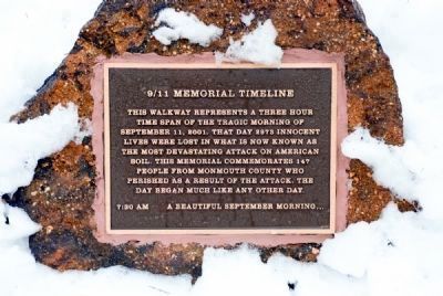
On September 11, 2001, many came to this site to witness the horrific tragedy just a few miles away in Lower Manhattan, and, for days afterward, they continued to come to view the smoke spiraling up from the site, most still in shock, not believing . . . — — Map (db m5981) HM
On Court Street, on the right when traveling west.
This monument commemorates the pivotal June 28, 1778 Battle of Monmouth which began near this site. A campaign to erect the memorial, led by Freehold native Governor Joel Parker and Major James S. Yard, began in 1877. Its cornerstone was laid on . . . — — Map (db m53132) HM
On Court Street, on the right when traveling east.
In memory of the Revolutionary ancestors of Monmouth Court House Chapter Daughters of the American Revolution Freehold, New Jersey. 1937 — — Map (db m53135) HM
Monmouth County Historical Site
Columbia Triumphant Park
This granite carving of Columbia Triumphant–also known as Liberty Triumphant–was part of the original statue placed atop the monument located on nearby Court Street commemorating the . . . — — Map (db m7066) HM
Near Ocean Blvd, on the right when traveling north.
Boating is a popular activity on Raritan and Sandy Hook bays. These waters provide both shelter from and access to the Atlantic Ocean. Over the past three centuries, maritime traffic in the Raritan Bay – New York Harbor area has increased . . . — — Map (db m22730) HM
Generations of Waln/Meirs women helped to build and sustain the farm, mill and domestic life at Walnford and to ensure its ultimate survival. Sarah Ridgeway Waln and her daughter Sarah Waln were among a small but noteworthy group of women who owned . . . — — Map (db m93732) HM
Mount Mitchill, at an elevation of 266 feet above sea level, is the highest natural point on the Atlantic Seaboard between southern Maine and the Yucatan Peninsula of Mexico. Cartographers (map makers) named the prominence, located in the southwest . . . — — Map (db m22716) HM
Hartshorne Woods Park is named in honor of the Hartshorne family. Richard Hartshorne (1641-1722), an English Quaker, settled in Middletown in 1669 and became one of Monmouth County’s most prominent early settlers. By the late 1670s he had acquired . . . — — Map (db m40751) HM
Geraldine Morgan Thompson, “First Lady of New Jersey” moved to Brookdale Farm upon her marriage in 1896 and lived here until her death in 1967 During her lifetime she served as New Jersey’s first woman state delegate to the Republican . . . — — Map (db m93758) HM
On Heyers Mill Road, on the right when traveling north.
In tribute to Capt. Joshua Huddy of Colts Neck 1750 – 1782 Monmouth County Revolutionary War hero. Erected by the citizens of Colts Neck August 27, 1977 — — Map (db m76469) HM
Near Ocean Blvd, on the right when traveling north.
Most shore bathers soon realize the back-and-forth motion of the waves breaking on the shore not only stirs the sand but also persistently carries them down the beach. This unseen force is called a “longshore or littoral current.” In . . . — — Map (db m22742) HM
On Gateway NRA Road, on the left when traveling north.
Established in 1943, to store and supply ammunition for the Atlantic fleet, the Earle Naval Weapons Station plays a key role in protecting American coastal cities and ports. Its deep-water pier is 2.9 miles long and can service several naval vessels . . . — — Map (db m22664) HM
Near Baird Road 0.2 miles west of Wagner Farm Lane, on the left when traveling east.
You are surrounded by history wherever you travel in Millstone Township. Historic farms and nurseries fill this rolling landscape of low hills rising above the surrounding Coastal Plain. Community life here has long been centered on small . . . — — Map (db m310187) HM
Near Baird Road west of Wagner Farm Lane, on the right when traveling west.
The property on which you are standing was part of a larger block of land owned by the Baird descendants. Generations of farmers have tilled the land from the 1830s, passing through several owners until 2012 when it was acquired by Millstone . . . — — Map (db m310331) HM
On Tennent Road at Church Lane, on the right when traveling north on Tennent Road.
This monument is dedicated to the memory of the Soldiers and Sailors of Monmouth county who sacrificed their lives in the World War 1914-1918. Erected by the Membership and officers of the Old Tennent Church, 1920 — — Map (db m155932) HM WM
On Throckmorton Street, on the left when traveling east.
Listed on the New Jersey Register of Historic Places December 22, 1997 Listed on the National Register of Historic Places March 19, 1998 First Service – October 10, 1701 Construction begun on this site – July 1771 Restoration program . . . — — Map (db m53138) HM
On Branchport Avenue at Russell Avenue, on the left when traveling north on Branchport Avenue.
Constructed in 1906, this is the 4th and present home of the Neptune Hose Co No.1. Formerly the Neptune Hook & Ladder Co. Founded in 1866 by Dr. James O. Green, following the burning of the Bath Hotel, it was the first organized fire company in . . . — — Map (db m168851) HM
Eloquently fired the spirit of the people with poems and ballads promoting the cause of liberty. Friend of James Madison and Thomas Jefferson, published the Jersey Chronicle, first newspaper in Monmouth County. — — Map (db m76324) HM
Near County Route 524, on the left when traveling west.
From 1929 to 1940 Arthur Brisbane made available this land as the official scout camp for Monmouth County Boy Scouts. Thousands of boys camped here enjoying the natural beauty of the woods while receiving scout training in self-reliance and kindred . . . — — Map (db m53140) HM
On Pender Avenue west of South 21st Street, on the left when traveling west.
Bungalow built for Henry Hankins Hall (1885-1946), native of Suffolk, VA, hardware salesman for N. Jacobi Company, and wife, Olive Ewing (1890-1981), native of Monmouth County, NJ. Purchased in 1967 by Collier Hobbs Tolar (1938-2009), clerk at . . . — — Map (db m266432) HM
On East Water Street, on the right when traveling east.
Joshua Huddy is celebrated as the Patriot hero of the Toms River Blockhouse Fight, but few know about his colorful past. Huddy was born in 1735 in Salem County, New Jersey. He was the oldest of seven brothers. Although he was raised in a . . . — — Map (db m139186) HM
On Friendship-Speedwell Road at Hawkins-Speedwell Road, on the left when traveling west on Friendship-Speedwell Road.
Saw Mill Built by Daniel Randolph, 1770. Furnace and forge by Benjamin Randolph, 1773. Log house standing until 1948, also log schoolhouse here. — — Map (db m244465) HM
On Monmouth Street at Bridge Avenue, on the right when traveling east on Monmouth Street.
This is believed to be one of the only remaining booths which were once common throughout early rail travel in New Jersey. Buildings such as this provided shelter, warmth, and minimal comforts for the Gate Keeper. These buildings, however, became . . . — — Map (db m82802) HM
On Hamden Road, on the right when traveling north.
In 1759 Phillip and John Grandin acquired 1,000 acres known as the Hamden Tract.
Hamden was home to the Grandin Grist & Fulling-Mills, a Blacksmith Shop, and Abbott's Tavern.
Dr. John Grandin's house was built in 1775 with pitch pine lumber that . . . — — Map (db m132105) HM
On Water Street, on the left when traveling south.
This piece of land has always been called the Bluff, meaning a hill with a broad, steep face. This site’s history suggests another meaning for bluff – to hoodwink. It was here that a delaying tactic permitted an escape, that a fugitive found . . . — — Map (db m25112) HM
On Oakley Drive just east of Wemrock Road, on the left when traveling east.
Originally a 500 acre subsistence farm. Ownership was granted by the King of England and the Proprietors of East Jersey until after the American Revolution. Thirteen different owners occupied this land. The Oakley family were the last owners. In . . . — — Map (db m309163) HM
First known as the Reformed Church of Freehold and Middletown, it divided in 1825 and became “The First Reformed Church of Freehold.” In 1931 its name was changed to “The Old Brick Reformed Church.”
The first building . . . — — Map (db m93773) HM
Near Ocean Avenue North just south of Joline Avenue, on the right when traveling north.
• Seabeach amaranth had not been seen on Monmouth County beaches since 1899 or elsewhere in New Jersey since 1913, but now the plant is back! It was rediscovered in July 2000 in Sea Bright, Monmouth Beach, and Sandy Hook. Biologists are not . . . — — Map (db m208285) HM
Built in 1879.
Named for the seven U.S. Presidents who attended services here: Ulysses S. Grant, Rutherford B. Hayes, James A. Garfield, Chester A. Arthur, Benjamin Harrison, William McKinley, and Woodrow Wilson.
Deconsecrated in 1953, . . . — — Map (db m14049) HM
On East Water Street, on the right when traveling east.
After the Toms River Blockhouse fight, British sailors and soldiers hunted for Captain Joshua Huddy who had escaped into the surrounding area. The Associated Loyalists, a unit organized by the former Tory Governor of New Jersey, William Franklin . . . — — Map (db m139169) HM
Near South Clinton Avenue near Barlow Street. Reported missing.
Born April 16, 1814, in Tuckerton, NJ.
He operated country general stores throughout Burlington and Monmouth Counties before moving to Trenton.
He served as Chancery Court clerk of New Jersey from 1851 to 1856 and served as mayor of Trenton . . . — — Map (db m9891) HM
On North Broadway south of Church Street, on the right when traveling south.
The City of South Amboy was first settled in 1685 and was known as Radford's Ferry and the South Ward of Perth Amboy. The name "Amboy" comes from Native-American word "Amboge." South Amboy was formally incorporated into a township in 1798 and . . . — — Map (db m293080) HM
The settlement of Quakers in the colony of New Jersey is regarded as an important contribution to a progressive tradition in the state. Then as now, Quakers believed in equality and in granting women a unique role in their communities. Quakers . . . — — Map (db m93753) HM
On North Main Street (U.S. 9) at Hilliard Drive, on the left when traveling north on North Main Street.
The Randolph farmstead dates from approximately the year that Stafford Township was established by separating from Shrewsbury Township in Monmouth County. The building has served as home for several of our noted citizens. Reuben Randolph was the . . . — — Map (db m209252) HM
Here
Captain Joshua Huddy
of the Monmouth County Artillery
A Prisoner of War
Captured March 24, 1782 while defending
the Block House at Tom's River. Was hung by Torries without warrant April 12, 1782
The British authorities repudiated . . . — — Map (db m5657) HM
On East Charleston Avenue west of Walter A Gaines Way, on the right when traveling west.
Fort Mercer, October 1777
At least 4% of Continental Army soldiers comprised men of African, Native American, or mixed ancestry. In the 1st and 2nd Rhode Island regiments, persons of color amounted to almost 15% of the men. In October 1777, . . . — — Map (db m304293) HM
On Washington Street just east of Robbins Street, on the right when traveling east.
Downtown Toms River, also called the "village," includes both residential and commercial properties. None of these properties are as old as the town itself when it was separated from Shrewsbury Township, Monmouth County in 1767 and was . . . — — Map (db m208342) HM
Near John A Quitman Boulevard west of Melrose Avenue, on the left when traveling west.
Natchez postmaster John Hankinson built Monmouth on two adjacent, 15-acre tracts, in 1818. He named his estate after his place of origin in Monmouth County, New Jersey. Monmouth was sold in 1826, to John A. Quitman. Quitman, born in New York, lived . . . — — Map (db m243751) HM
On West State Street 0.1 miles west of North Willow Street, on the right when traveling west.
"The American people, in their righteous might will win through absolute victory."
President Franklin D. Roosevelt
"Our debt to the heroic men and women in the service of our country can never be repaid. They have . . . — — Map (db m160232) HM WM
Thin black lines indicate changes in relevance. Between each pair of lines entries are ordered geographically but all have the same relevance.
* Inflectional forms of words are their plurals, singulars, and possessives as well as gramatical tenses and similar variations.