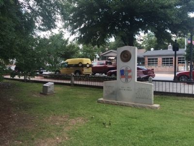
On Lawrenceville Highway (U.S. 29) east of North Perry Street (County Route 20), on the left when traveling west. Reported permanently removed.
In remembrance
of the citizens
of Gwinnett
County who
honorably served
the Confederate
States of America
"Any people with
contempt for their
heritage have lost
faith in themselves
and no nation can long
survive without . . . — — Map (db m85724) WM
On North Clayton Street at East Pike Street (U.S. 29), on the right when traveling north on North Clayton Street.
William E. Simmons, one of Gwinnett County’s foremost citizens, was born in Lawrenceville on August 26, 1839. After graduating at the top of his class from Emory College, he assumed editorship of the Lawrenceville News. In 1861, he became an officer . . . — — Map (db m16958) HM
On Sunset Drive at North Peachtree Street, on the right when traveling west on Sunset Drive.
Sunset Drive, originally known as Church Street, and later “Holy Row” has a long and storied past. On November 5, 1875 Norman Flavius Cooledge, an educator, bought the parcel of land (currently the site of the Summerour House) on the corner of . . . — — Map (db m44073) HM
On West Peachtree Street at Park Drive NW, on the right when traveling south on West Peachtree Street.
On May 17, 1872, seventeen people convened in the Community House on Church Street or “Holy Row,” now called Sunset Drive, in the fledgling town of Norcross. During the meeting, this inspired group organized The Baptist Church of Christ . . . — — Map (db m16961) HM
On Lawrenceville Street NW 0 miles north of Jones Street NW, on the left when traveling north.
The Norcross Historic District has been preserved as a 19th century railroad town, and its historical significance has been recognized by the U. S. Department of the Interior through its listing on the National Register of Historic Places on . . . — — Map (db m35039) HM
On Jones Street NW at Lawrenceville Street NW, on the left when traveling east on Jones Street NW.
Originally chartered in 1833 by the Fairview Presbyterian Church of Lawrenceville, the church was originally located at the intersection of Beaver Ruin Road and Hopkins Mill Road on land donated by Thomas H. Jones and was known as the Goshen . . . — — Map (db m23285) HM
Near South Perry Street (Georgia Route 20) at Luckie Street, on the left when traveling south.
The Georgia Legislature authorized the creation of Gwinnett County in 1818 and named it after Button Gwinnett. He was one of three Georgia signers of the Declaration of Independence but never lived in the county.
The first meetings, court . . . — — Map (db m197711) HM
Near Valley Forge Road (Pennsylvania Route 23), on the left when traveling west.
Honor Court to
Brigadier General Lachlan McIntosh
A General charged with the Safety of
George Washington,
the Commander in Chief of the
Continental Army at Valley Forge 1777-78
A Native of Georgia in Command of the
“Life . . . — — Map (db m51742) HM
On Lawrenceville Highway (U.S. 29) 0.1 miles west of Sugarloaf Parkway, on the right when traveling west.
Richard Dickinson Winn, a son of Elisha and Judith Cochran Winn, was born January 14, 1816. Gwinnett’s first county elections and court sessions were held at his childhood home near Hog Mountain. Winn served as a Justice of the Inferior Court of . . . — — Map (db m23541) HM
On Mount Vernon Road at Jett Ferry Road, on the right when traveling east on Mount Vernon Road.
The Hightower (English version of “Etowah”) Indian trail passed here in its route from East Georgia to the mountains of North Georgia. To the northwest, it crossed a ford on the Chattahoochee River at Roswell. This trade and travel path . . . — — Map (db m50372) HM
On Dacula Road 0.6 miles south of Hog Mountain Dacula Road (Georgia Route 324), on the left when traveling south.
This house was built by Elisha Winn around 1812. In 1818, the Georgia General Assembly created Gwinnett County from Cherokee and Creek cessions and part of Jackson County. The first Gwinnett elections and sessions of the Inferior Court were held in . . . — — Map (db m16937) HM
Near South Perry Street (Georgia Route 20) south of Luckie Street, on the left when traveling south.
[Left panel]
After the Civil War, railroads came to Gwinnett County. New cities emerged along the rails, including Buford, Duluth, Norcross, and Suwanee. Confederate veteran Bonaparte Allen moved to Buford and opened a tannery that became . . . — — Map (db m197729) HM
Near South Clayton Street (Georgia Route 20) south of Luckie Street, on the right when traveling south.
[Left panel]
Early Gwinnett and adjacent counties were home to two important U.S. Army forts: Fort Daniel on Hog Mountain and Fort Gilmer along the Chattahoochee River, more commonly called "the fort at the standing peach tree.” During the . . . — — Map (db m197723) HM
On East Crogan Street east of South Clayton Street, on the right when traveling east.
As in most counties in this part of Georgia, there were a few local entrepreneurs who developed a thriving business producing a popular variety of white lightnin'. Customers came from miles around for a chance to purchase some of Gwinnett's finest . . . — — Map (db m197679) HM
Near Lawrenceville Street Northwest west of Mitchell Road NW, on the left when traveling east.
In the early 1900s cotton was the main cash crop for farmers in Georgia, and to prepare their harvest for market their cotton bolls had to be run through a machine called a cotton gin to separate the fiber from the seeds. The Summerour Cotton Gin, . . . — — Map (db m212992) HM
On Sandy Springs Circle at Sandy Springs Place, on the right when traveling north on Sandy Springs Circle.
Sandy Springs, Georgia, the unincorporated community just north of Atlanta, began a 30-year campaign for incorporation when the City of Atlanta tried to annex the area in the 1970s. The Committee for Sandy Springs formed in 1975 to incorporate Sandy . . . — — Map (db m53430) HM
Near South Poplar Street north of Oak Street, on the left when traveling north.
Run -off water from the upper piedmont forms the Oconee (a Native American word meaning "river").
Below the Appalachian Mountains of North Georgia, the Oconee River headwaters begin in the rolling hill country of Hall and Gwinnett Counties . . . — — Map (db m207633) HM
On Alcovy Road SE west of Sweet Pond Road, on the right when traveling west.
Welcome to Freeman's Mill, the last operating gristmill in Gwinnett County. From the late 1860s to 1986, Freeman's Mill provided wheat flour, corn meal and feed meal for the county's residents and their animals. Its pond afforded nearby Alcova . . . — — Map (db m114273) HM
Near South Clayton Street (Georgia Route 20) south of Luckie Street, on the right when traveling south.
Long before Gwinnett County became today's vibrantly connected community, it was a forest. The Cherokee and Creek people lived and hunted on these ancestral lands. Early settlers grew subsistence crops like corn.
Cotton produced by slave labor . . . — — Map (db m197726) HM
Near South Perry Street (Georgia Route 20) south of Luckie Street, on the left when traveling south.
[Left panel]
Quality of life in Gwinnett is unsurpassed with educational choices from Pre-K to PhD, housing variety from single-family subdivisions to downtown condos to large-tract estates, and entertainment options that include five . . . — — Map (db m197728) HM
Near South Perry Street (Georgia Route 20) at Luckie Street, on the left when traveling south.
The state of Georgia divided land ceded by the Cherokee Nation into 250-acre lots for farming and gave them away in the Land Lottery of 1820. To be eligible, participants had to be at least 18 and a Georgia resident for three years. Lottery winners . . . — — Map (db m197713) HM
Near Clean Water Drive 0.8 miles south of Plunkett Road.
One of the oldest surviving homes in Gwinnett County, this house was built in the 1850s. The house was originally two rooms wide and one room deep. This style is referred to as an I-house. The house is unique because of the beautiful, hand painted . . . — — Map (db m107606) HM
Near South Perry Street (Georgia Route 20) at Luckie Street, on the left when traveling south.
[Left panel]
Present day Northwest Georgia was a very different place in the late 1700s. Due to conflict with the region's Creek and Cherokee people, white settlers constructed small forts to protect themselves along treaty boundaries. One . . . — — Map (db m197714) HM
On 5th Street (U.S. 411) at 7th Avenue, on the right when traveling south on 5th Street.
Greek revival antebellum home built by Moses Dean in 1852, acquired by John W. Inzer in 1866. Home occupied by Inzer family from 1866 to 1987. In July 1987 home and its contents, including extensive law library, deeded by family heirs to St. Clair . . . — — Map (db m28092) HM
On College Street at Jones Street, on the right when traveling north on College Street.
As a pioneer for women in Norcross and Gwinnett County politics, Lillian Webb built a distinguished career that stretched nearly sixty years and spanned local, county, state, and national levels. She began her activism in 1950 as an organizer, . . . — — Map (db m212993) HM
On North Perry Street (Georgia Route 20) at Lawrenceville Highway ( Route 8), on the left when traveling south on North Perry Street.
Lynching in America
Thousands of Black people were victims of lynching in the United States between 1865 and 1950. During this era, lynching emerged as the most notorious and public form of racial terrorism, used to enforce racial hierarchy and . . . — — Map (db m197693) HM
On Ravine Loop Trail, on the right when traveling west.
These stone structures range from neatly stacked cubic assemblies to scattered piles of rock (that appear to formerly have been neatly stacked). Some are stacked five to six feet tall. There are hundreds of these mounds scattered in various . . . — — Map (db m114344) HM
On South Peachtree Street just south of Jones Street Northwest, on the left when traveling south.
Norcross was incorporated in 1870
by John J. Thrasher, a pioneer Atlanta settler who named this town after his good friend and business associate, Jonathan Norcross. The town of Norcross was the second city in Gwinnett County, and the first . . . — — Map (db m221159) HM
Near South Clayton Street (Georgia Route 20) at Luckie Street, on the right when traveling south.
[Left panel]
Lake Lanier is one of Gwinnett 's recreational gems and engineering feats, named in honor of Georgia poet and musician Sidney Lanier.
The U.S. Army Corps of Engineers broke ground on Buford Dam in 1950. The dam's . . . — — Map (db m197719) HM
On Miller Loop Trail, on the right when traveling west.
The preserve was dedicated by Gwinnett County in 2005 on land purchased from the Miller family. The preserve includes 200 acres of land to remain undisturbed for future generations. It contains a variety of wildlife including mammals, birds, . . . — — Map (db m114324) HM
Thin black lines indicate changes in relevance. Between each pair of lines entries are ordered geographically but all have the same relevance.
* Inflectional forms of words are their plurals, singulars, and possessives as well as gramatical tenses and similar variations.