By Richard Denney, November 19, 2014
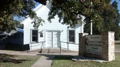
Haynie Chapel Methodist Church and Marker
RANKED BY RELEVANCE
| On Greenwood Drive at Houston Road, on the right when traveling east on Greenwood Drive. |
| On Central Avenue (U.S. 67/377) near Houston Street, on the right when traveling west. |
| On Central Avenue (U.S. 67/277) at Houston Street, on the right when traveling west on Central Avenue. |
| On West Central Avenue (U.S. 377) at State Highway 36 on West Central Avenue. |
| On North Texas Street (State Highway 16) at West LaSalle Street, on the left when traveling north on North Texas Street. |
| On Central Avenue (U.S. 67/377) at Houston Street, on the right when traveling west on Central Avenue. |
| On Elm Pass Road at San Antonio Road (Farm to Market Road 480), on the left when traveling south on Elm Pass Road. |
| On W. Houston St. at N. Flores St., on the right when traveling west on W. Houston St.. |
| Near Bryan Street at East Cedar Avenue. |
| On Central Avenue (U.S. 67/377) at Houston Street, on the right when traveling west on Central Avenue. |
| On South Tarragona Street south of Church Street, on the right when traveling south. |
| On North Austin Street (State Highway 16) at West Central Avenue, on the left when traveling north on North Austin Street. |
| On North Houston Street at West Central Street (State Highway 36), on the left when traveling north on North Houston Street. |
| On Commerce Street at Main Plaza, on the left when traveling west on Commerce Street. |
| On Central Avenue (U.S. 67/377) at Houston Street, on the right when traveling west on Central Avenue. |
| On 36th Division Memorial Highway (State Highway 36) just west of West Main Street, on the right when traveling west. |
| On County Highway 108 0.5 miles north of 36th Division Memorial Highway (State Highway 36), on the right when traveling east. |
| On Grand Avenue west of Houston Street, on the right when traveling west. |
| On East College Avenue west of Cimarron Trail, on the right when traveling west. |
| On West Central Avenue west of South 9th Street, on the right when traveling west. |
| On North Austin Street (State Highway 16) at East Paine Avenue, on the right when traveling north on North Austin Street. |
| On S. Festival Lane 0.1 miles south of East Navarro Avenue, on the right when traveling south. |
| On North Austin Street (State Highway 16) at West Grand Avenue, on the left when traveling north on North Austin Street. |
| On Bryan Street near East Cedar Avenue, on the right when traveling north. |
| On U.S. 377 at County Highway 317, on the right when traveling east on U.S. 377. |
| Near Cox Cemetery Road 0.2 miles south of Farm to Market Road 589. |
| On Pecan Street 0.3 miles south of East Garfield Street (U.S. 277), on the right when traveling north. |
| On Moorman Road at Hillcrest Street, on the left when traveling west on Moorman Road. |
| On County Road 415 0.2 miles south of County Road 413, on the left when traveling south. |
| On 36th Division Memorial Highway (State Highway 36) at West Main Street, on the left when traveling east on 36th Division Memorial Highway. |
| On County Highway 157 0.4 miles east of Farm to Market Road 1689, on the left when traveling east. |
| Near East Austin Street at North Washington Street. |
| On Farm to Market Road 1229 8.8 miles south of State Highway 350, on the right when traveling south. |
Thin black lines indicate changes in relevance. Between each pair of lines entries are ordered geographically but all have the same relevance.* Inflectional forms of words are their plurals, singulars, and possessives as well as gramatical tenses and similar variations.
Nov. 13, 2026
