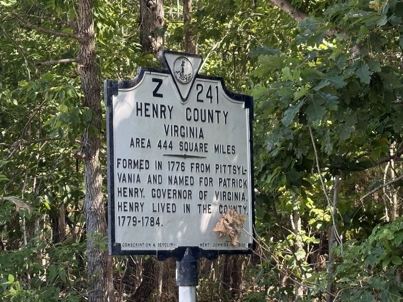
By Devry Becker Jones (CC0), July 2, 2026
Henry County Virginia side of the marker
RANKED BY RELEVANCE
On Morehead Avenue (Virginia Route 87) south of Doyle Road (County Road 835), on the right when traveling north.
Near Virginia Avenue (Business U.S. 220) at Commonwealth Boulevard, on the right when traveling north. Reported unreadable.
Near Doyle Street at Hooker Street, on the left when traveling west.
Near Fisher Street at Fishel Street ( Route 174), on the right when traveling east.
Near Fisher Street at Fishel Street ( Route 174), on the right when traveling east.
Near Virginia Avenue (Business U.S. 220) at Commonwealth Boulevard, on the right when traveling north.
Near Doyle Street at Hooker Street, on the left when traveling west.
Near Fisher Street at Fishel Street, on the left when traveling east.
Near Stultz Road at Liberty Street ( Route 174), on the left when traveling west.
Near Stultz Road at Liberty Street ( Route 174), on the left when traveling west.
On U.S. 58 at Business U.S. 58, on the right when traveling east on U.S. 58.
On Cemetery Street 0.1 miles west of Moss Street South, on the left when traveling west.
On Jones Street (Virginia Route 457) at East Main Street, on the left when traveling north on Jones Street.
On US 220, on the right when traveling north.
Paid Advertisement
Near Letcher Lane (Virginia Route 749) 0.5 miles west of Ararat Highway ( Route 773), on the left when traveling west.
On Old Liberty Drive, on the right when traveling west.
On Broad Street (State Road 38) at South Main Street, on the right when traveling east on Broad Street.
On Main Street (Jefferson Davis Memorial Highway) at Norwood Street on Main Street (Jefferson Davis Memorial Highway).
Near Letcher Lane (Virginia Route 749) at Ararat Highway ( Route 773), on the left when traveling west.
Near Jeddo Road (County Highway 297) 0.2 miles north of Farm to Market Road 713.
On Sutherlin Avenue south of Main Street ( Route 293), on the left when traveling north.
On Riverside Drive at Fairystone Park Highway ( Route 57), on the right when traveling south on Riverside Drive.
Near Franklin Street 0.1 miles north of Depot Street, on the right when traveling north.
On Abram Penn Highway (County Route 626) at Kootes Mill Road (County Route 703), on the left when traveling north on Abram Penn Highway. Reported permanently removed.
On Sago Road 0.5 miles north of Callands Road ( Route 57), on the right when traveling north.
On Lee Highway (U.S. 11) south of 2nd Avenue, on the right when traveling north.
On Virginia Avenue (U.S. 220) at Oak Forest Road ( Route 984), in the median on Virginia Avenue.
On A L Philpott Highway (U.S. 58) west of Turnpike Road, on the right when traveling west.
On Koger Mill Road at Abram Penn Highway ( Route 626), on the left when traveling west on Koger Mill Road.
On Alabama Route 27 at County Road 7, on the right when traveling east on Alabama Route 27.
Paid Advertisement
On Greensboro Road (Business U.S. 220) at Joseph Martin Highway (County Route 685), on the left when traveling north on Greensboro Road.
On Turkey Creek Road at Raymond Stotzer Frontage, on the left when traveling north on Turkey Creek Road.
Near Wilderness Road (U.S. 58) at Baileytown Road (Virginia Route 690).
Near Price Lane 0.1 miles south of State Route 7/13, on the right when traveling south.
On West Main Street (Virginia Route 293) at Mount Vernon Avenue, on the right when traveling east on West Main Street.
︽
Thin black lines indicate changes in relevance. Between each pair of lines entries are ordered geographically but all have the same relevance. * Inflectional forms of words are their plurals, singulars, and possessives as well as gramatical tenses and similar variations.
Nov. 13, 2026