On Main Street (State Highway 159) just north of State Highway 142, on the left when traveling north.
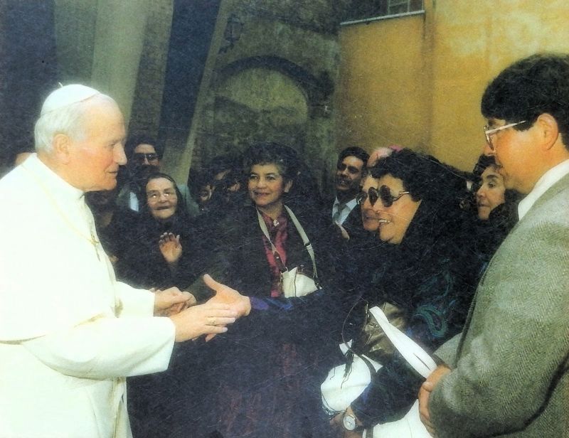
In May 1991 Rev. Pat Valdez of the Sangre de Cristo Church journeyed to Rome with twenty-nine parishioners for an audience with Pope John Paul II. They were accompanied by sculptor Huberto Maestas, a San Luis native and creator of the town's . . . — — Map (db m293688) HM
On Main Street (State Highway 159) just north of 6th Street, on the right when traveling north.
The birthplace of Colorado is here! On April 9, 1851, the Town of San Luis was founded as the first permanent settlement in Colorado. This settlement was in the northernmost frontier of Hispano lands and very few ventured into this unknown . . . — — Map (db m294296) HM
Near 4th Street (County Road P.6) at West Church Place, on the right when traveling west.
[left panel] All the inhabitants shall have use of pasture, wood, water, and timber and the mills that have been erected shall remain where they are, not interfering with the rights of others. No stock shall be allowed in said . . . — — Map (db m294491) HM
On Main Street (State Highway 159) just north of State Highway 142, on the left when traveling north.
Colorado's earliest non-Indian occupants were Hispanos. Migrating north from present-day New Mexico in the mid-1800s. These colonists battled the Ute Indians for control of the San Luis Valley while the United States and Mexico warred over the . . . — — Map (db m293599) HM
Near 4th Street (County Road P.6) at West Church Place, on the right when traveling west.
In honor and memory of those from San Luis and Costilla County who gave their lives in defense of freedom World War II Korean War Vietnam War — — Map (db m294479) WM
On Main Street (State Highway 159) just south of Archie Street, on the left when traveling south.
Commemorating the historical importance of the pioneers who were responsible for the first permanent settlement in Colorado.1851 ——— This tablet is the property of the State of Colorado ——— Erected by the State Historical Society of Colorado . . . — — Map (db m281599) HM
On Main Street (State Highway 159) just north of State Highway 142, on the left when traveling south.
The Silver Thread Scenic and Historic Byway travels through the upper Rio Grande Valley and crosses the Continental Divide. Creede, Lake City, and South Fork are historical complements to this extraordinary scenic byway. Our Lady of Guadalupe . . . — — Map (db m293698) HM
On Main Street (State Highway 159) just north of 6th Street, on the right when traveling north.
What is a National Heritage Area? A national heritage area is a region recognized by the United States Congress for its unique qualities and resources — natural, scenic, cultural, historic, and recreational. Rich in history, religion, . . . — — Map (db m294295) HM
On U.S. 160 0.2 miles west of County Road 402, on the left when traveling west.
Adventure! Hiking the Continental Divide National Scenic Trail offers you an enormous challenge.
Beginning at Mexico’s border in southern New Mexico, the country’s longest National Scenic Trail wanders through Colorado, Wyoming, and Idaho, . . . — — Map (db m71661) HM
On U.S. 160 0.2 miles west of County Road 402, on the left when traveling west.
Wolf Creek Pass! A romantic name - a beautiful but harsh setting.
Squatter-trapper Bill Wolf probably wasn't the first man across the pass, though it bears his name. Until the early 1900's, Cumbres and Elwood Passes opened the way to fertile . . . — — Map (db m71659) HM
On U.S. 160 0.2 miles County Road 402, on the left when traveling west.
Water! Every drop has a destiny via the continent’s backbone: the Continental Divide.
With a foot on each side of the bronze line below, you are symbolically straddling the spine of the Western Hemisphere. In North America the Divide follows . . . — — Map (db m71660)
1. Some 10,500 years ago, the San Juan Mountains were well-known to post-ice age hunters. The Folsom culture, as they are now called, hunted bison and gathered plants in high mountain valleys.
2. More recently, Ute Indians lived in this area and . . . — — Map (db m153322) HM
Near U.S. 160 at milepost 191.4, 0.1 miles west of County Road 50, on the right when traveling west.
Few Spaniards glimpsed the uppermost reaches of the mysterious Rio Grande del Norte — and those who did, did so by chance. In 1694 Diego de Vargas came nearly as far north as present-day Alamosa while detouring around hostile Pueblos, and Juan . . . — — Map (db m267998) HM
Near U.S. 160 at milepost 191.4, 0.1 miles west of County Road 50, on the right when traveling west.
Cascading through the town of South Fork just west of here, the Rio Grande serves as a portal between two radically different worlds. To the west lie the roughhewn peaks and cloistered canyons of the San Juan Mountains. For centuries an impregnable . . . — — Map (db m267999) HM
Lake City — A City of Elegance
Lake City was founded in 1874 and soon became the center for one of the richest lead and silver mining areas in Colorado. The 1870s were peak years for growth in Lake City but unlike most mining . . . — — Map (db m153323) HM
Every drop of water has a destiny.
From its pristine headwaters, approximately
fifty miles west of Creede, the Rio Grande
travels 1,885-miles through three states
on its journey to the Gulf of Mexico.
The mighty Rio Grande humbly . . . — — Map (db m160576) HM
Near U.S. 160 at milepost 191.4, 0.1 miles west of County Road 50, on the right when traveling west.
While in Saguache in 1874, Alfred Packer was arrested on murder charges involving cannibalism. He escaped, but was caught, tried twice, sentenced to forty years in prison, and later pardoned. Though Packer was not incarcerated in the Saguache . . . — — Map (db m268123) HM
Near U.S. 160 at milepost 191.4, 0.1 miles west of County Road 50, on the right when traveling west.
The StagecoachBunker Hill Station, established not far from here in 1876, anchored the last bastion of the Barlow and Sanderson Stage Company. Railroads had supplanted most of the company's routes in the San Luis Valley by the . . . — — Map (db m267988) HM
As you travel the Silver Thread Scenic Byway, through the heart of the San Juan
Mountains, watch for wildlife. Elk, moose, mule deer, and bighorn sheep can be found along streams or rivers or in open meadows. Look near a forest edge or on a . . . — — Map (db m153324) HM
On 8th Street (U.S. 286) at Pitkin Avenue, on the right when traveling north on 8th Street.
Left plaque
George W. Hazard (1868-1938) was the second child of James Glann and Mary L (Stoddard) Hazard, and the only child to survive childhood. His older brother Henry died at the age of ten, and his younger sister Cora died in . . . — — Map (db m120162) HM
On 8th Street (State Highway 285) at Christy Avenue, on the right when traveling north on 8th Street.
This sign marks an important junction of the Old Spanish Trail. Both forks, east and west, of the North Branch of this Trail converged at Saguache before continuing west of Cochetopa Pass and on to Los Angeles.
The Old Spanish Trail was the . . . — — Map (db m120165) HM
On 8th Street (State Highway 285) north of Pitkin Avenue, on the right when traveling north.
This park is dedicated to Otto Mears, Russian-born Colorado Pioneer, know as “The Pathfinder of the San Juan”, who came to the San Luis Valley in 1865. In Saguache (A Ute Indian word meaning “blue earth”), Otto Mears was married in 1870, . . . — — Map (db m120163) HM
On 8th Street (State Highway 285) at Christy Avenue, on the right when traveling north on 8th Street.
The land around Saguache (pronounced “sah-WATCH”) has been inhabited for thousands of years – first by unnamed nomads, later by the Utes (who camped here seasonally), and later still by Mexican traders bound for California on the . . . — — Map (db m120166) HM
On Front Street just east of Means Avenue (County Road 31XX), on the right when traveling east.
Originally established as Marshalltown in 1880, the little narrow-gauge railroad town was renamed in 1882 after Local Rancher, Postmaster and Merchant, Joseph Sargent. By 1881 Sargents had become the site of a D&RGW helper station. Many helper . . . — — Map (db m281900) HM
131 entries matched your criteria. Entries 101 through 131 are listed above. ⊲ Previous 100