On Metcalfe Street (County Road 18) at Geddes Street, on the right when traveling south on Metcalfe Street.
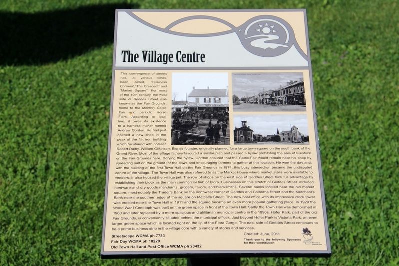
This convergence of streets has, at various times, been called, “Business Corners”, “The Crescent” and “Market Square”. For most of the 19th century, the west side of Geddes Street was known as the Fair Grounds, home to the Monthly Cattle Fair and . . . — — Map (db m196210) HM
On Main Street (County Road 124) just south of East Church Street, on the right when traveling south.
Meet Future Past 2412 Future Past 2412 combines the influence of the Victorian Era with the 21st Century in the style of Steampunk. By definition, Steampunk refers to a subgenre of science fiction and sometimes fantasy — also in . . . — — Map (db m243506) HM
On Main Street (County Road 124) just south of East Church Street, on the left when traveling south.
Welcome to the Village of Erin. As you can observe from the maps, the village is nestled in the valley of the West Credit River. Beginning in the 1820s, European settlers began to harness the power of the river to drive early mills. Erin prospered . . . — — Map (db m243400) HM
On Main Street (County Road 124) at Overland Drive, on the right when traveling south on Main Street.
Stanley Park started out on its history of being a premier tourist destination in the southern Ontario area, beginning with the purchase of 50 acres of land at the northwest corner of the Village of Erin in 1888 by James Long. During its heyday the . . . — — Map (db m243398) HM
On Main Street (County Road 124) at Overland Drive, on the right when traveling south on Main Street.
The process of officially designating the Stanley Park Gates & Arch under the Ontario Heritage Act was completed in September of 2017. The Gates and Arch are deemed to be of cultural heritage value, and interest. The designation recognizes their . . . — — Map (db m243399) HM
Near Menzies Lane, 0.1 kilometers west of St. David’s Road South.
Adam Fergusson (1782-1862) first visited Canada in 1831
to investigate emigration for the Highland Society of Scotland.
In 1833, in partnership with a fellow Scot, James Webster
(1808-69), he purchased over 7,000 acres of uncleared land
in . . . — — Map (db m218385) HM
On Quebec Street just east of Norfolk Street, on the right when traveling east.
The south eastern unit built 1853 by John Catchpole, tinsmith. Probably the first stone structure on Norfolk Street. John Howard added the larger corner section in 1864. Imposing mid 19th century styled masonry. Designated as a Building of . . . — — Map (db m208699) HM
On Carden Street just west of Wyndham Street North, on the left when traveling west.
[English] Many Canadian cities erected well-designed municipal buildings during the mid-19th century railway boom. Guelph City Hall, one of the best of this group, symbolized the city’s confidence in its future. Designed by Toronto . . . — — Map (db m208693) HM
On Carden Street at Wyndham Street North, on the right when traveling east on Carden Street.
This fine example of classical architecture was begun in 1856 following the incorporation of Guelph as a town. It was designed by William Thomas, architect of St. Lawrence Hall, Toronto, and other important buildings throughout the province, and was . . . — — Map (db m196191) HM
On Paisley Street at Norfolk Street, on the left when traveling east on Paisley Street.
[English] One of the first municipally supported libraries formed in Ontario following passage of the Free Libraries Act of 1882, the Guelph Public Library was established on February 10, 1883. It replaced the limited library . . . — — Map (db m199845) HM
On Carden Street just west of Wyndham Street North, on the left when traveling west.
This photo shows the original Town Hall and Market House designed by architect William Thomas. The building opened in 1857. The tower bell was rung daily at 7 a.m., 12 noon and 6 p.m., and during fires, funerals and special events. The central . . . — — Map (db m208695) HM
Near Woolwich Street, 0.1 kilometers west of Thorp Street, on the right when traveling west.
This graceful, arched bridge of reinforced concrete was built in 1914, replacing the original 1881 steel bridge, to plans by E.E. Clawson, City Engineer. A unique feature of the riverscape and important pedestrian link to the city's commercial core. . . . — — Map (db m196190) HM
On Carden Street just west of Wyndham Street North, on the left when traveling west.
History maker, novelist, poet and superintendent of the Canada Company, he founded Guelph on April 23, 1827. The opening of the Huron Tract in Upper Canada has been described as the most important single attempt at settlement in Canadian history. . . . — — Map (db m208694) HM
On Carden Street just west of Wyndham Street North, on the left when traveling west.
John Galt's 1827 plan for the Town of Guelph shows a central gathering place inside the large, triangular Market Grounds. Galt’s plan was based on planned towns he had seen in his travels including Buffalo, New York and Detroit, Michigan which used . . . — — Map (db m208696) HM
On Carden Street just east of Wilson Street, on the right when traveling east.
In 1899, based on the city's reputation for promoting advanced agriculture, Guelph's Market Square was selected to host the annual Provincial Winter Fair. The square was also used regularly for livestock competitions, cattle and horse auctions, . . . — — Map (db m208700) HM
On Quebec Street just east of Baker Street, on the left when traveling east.
Dedicated April 24, 1914 By M.W. Bro. The Hon. William David McPherson K.C. Grand Master Celebrated July 26, 2014 With M.W. Bro. Donald A. Campbell Grand Master — — Map (db m243397) HM
On Wyndham Street North at Macdonell Street, on the right when traveling south on Wyndham Street North.
In 1832 Canada Company Lot 108 was purchased by J.C.W. Daly, an agent of the Company. Later used as a merchant shop by Elizabeth Worsley, it was purchased from her estate in 1855 by the Emslie brothers, stone masons, builders, and owners of a . . . — — Map (db m208697) HM