On Bay Street, 0.2 kilometers south of Dennis Street, on the right when traveling south.
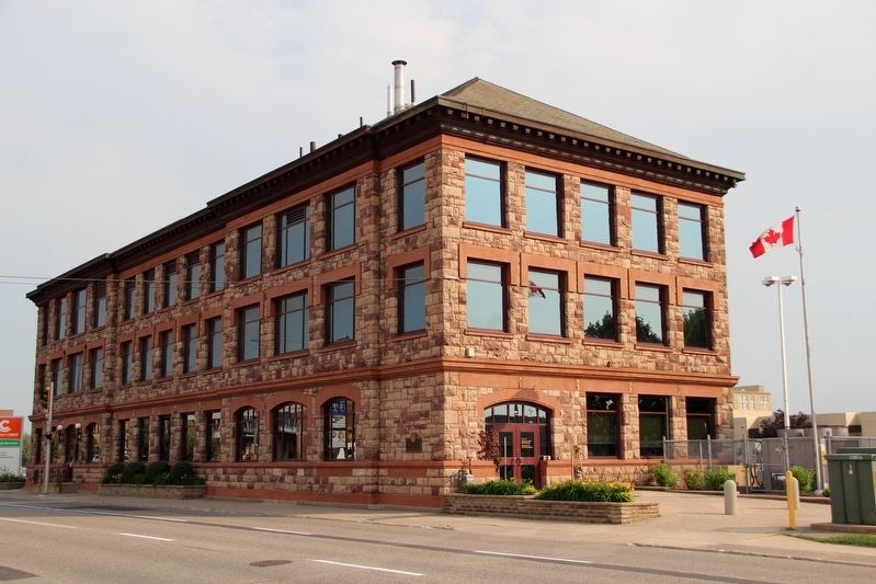
This building, built in 1912, was the terminal station and head office of the Algoma Central & Hudson Bay Railway Company. The A.C.R. was founded in 1899 by Francis Hector Clergue.
Re-dedicated on August 11, 1999 on the occasion of the company's . . . — — Map (db m198348) HM
On St Mary's River Drive, 0.2 kilometers west of Foster Drive, on the right when traveling south.
Born in Dublin, Ireland, and raised in London, this famous 19th century author, illustrator and social reformer joined her husband, Robert Jameson, Attorney General of Upper Canada, at Toronto in 1836. The following June, unescorted, Mrs. Jameson . . . — — Map (db m105960) HM
Near Lake Street, 0.6 kilometers south of Queen Street East.
Here, on a portion of his former estate, is buried Col. Prince who emigrated from England in 1833 and settled at Sandwich, Upper Canada. As commanding officer of the Essex Militia, he stirred up a violent controversy by ordering the summary . . . — — Map (db m105739) HM
On Foster Drive, 0.4 kilometers east of St Mary's River Drive, on the right when traveling east.
Dedicated at the official opening of Roberta Bondar Park In honour of our hero, Dr. Roberta Lynn Bondar, O.C., O.ONT., M.D., PH.D., F.R.C.P.(C), neurologist, biologist, pilot and researcher. Canada's first female astronaut was a crew member on the . . . — — Map (db m106415) HM
On Canal Drive, 1.2 kilometers west of Huron Street, on the left when traveling west.
[English] The Emergency Swing Bridge Dam was built by the Dominion Bridge company of Montreal in 1896. The dam was modeled on the American Sault Canal dam, but the Canadian design was modified and the structure built entirely of steel. . . . — — Map (db m198477) HM
This house, built between 1814 and 1823 by Charles Ermatinger of the North West Company, is the oldest surviving house in northwestern Ontario. Constructed when Sault Ste. Marie was still a small fur trading post on the Upper Lakes, this fine house . . . — — Map (db m105955) HM
On Hub Trail at Canal Drive, on the right when traveling north on Hub Trail.
A Maine-born promoter, Clergue transformed Sault Ste. Marie into a major industrial centre. He purchased an unfinished hydroelectric station and canal at the Sault in 1894; then, lacking markets for his electric power, he created his own . . . — — Map (db m106374) HM
Explorer, interpreter, fur trader and diplomat, French-born Perrot played an important role in the establishment and protection of New France's western frontier during the last four decades of the 17th century. In 1671 he was with Saint-Lusson at . . . — — Map (db m105957) HM
On Foster Drive, 0.4 kilometers east of St Mary's River Drive, on the right when traveling east.
Until the mid-20th century, passenger and packet freighters were the most efficient means for transporting goods and people to and from isolated communities of the Upper Great Lakes. Essential to early regional development and instrumental in the . . . — — Map (db m105959) HM
On Queen Street East, 0.2 kilometers west of Pim Street, on the right when traveling west.
This church was constructed in 1875 and dedicated in 1876 as the Parish Church of The Sacred Heart by Bishop Jean-Francois Jamot. It replaced a wooden building constructed in 1846 which had served as a Jesuit missionary post for this region. Built . . . — — Map (db m105953) HM
Near Canal Drive, 0.7 kilometers south of Huron Street, on the right when traveling east.
Completed in 1895, this canal formed the last link in an all-Canadian navigation system stretching from the St. Lawrence River to Lake Superior. Designed and built by Canadians, the canal incorporated several engineering innovations. It was the . . . — — Map (db m106185) HM
On Queen Street East, 0.2 kilometers west of Riverside Drive, on the right when traveling west.
Shingwauk Hall was erected in 1935 to house a residential training school established in 1873 by the Reverend Edward F. Wilson. Under this Anglican missionary's tutelage the institution, named after the well-known Ojibway Chief Augustin Shingwauk . . . — — Map (db m105738) HM
On Canal Drive, 1 kilometer west of Huron Street, on the right when traveling west.
In May, 1870, Col. Garnet Wolseley arrived here with an expeditionary force of British regulars and Canadian militia aboard the steamer "Chicora". They were travelling to Fort Garry on the Red River to put down an uprising led by Louis Riel. The . . . — — Map (db m106362) HM
On Huron Street, 0.1 kilometers south of Canal Drive, on the right when traveling south.
The French explorers who first reached this favoured Ojibway hunting and fishing ground were soon followed by fur traders and missionaries who built a post and mission. By 1762 the region had come under British control and the trade eventually fell . . . — — Map (db m106412) HM
On Canal Drive, 1.1 kilometers west of Huron Street, on the left when traveling west.
[English] You are standing beside the world's last Emergency Swing Dam. Only nine of these structures were ever built. Only this one was put to the ultimate test under emergency conditions.
In a 1909 emergency, this dam was swung across . . . — — Map (db m198462) HM
Near Hub Trail, 0.1 kilometers east of Canal Drive, on the right when traveling east.
Travellers on the canoe route to the West had to make a portage around the St. Mary's rapids. The North West Company established a fur-trading post south of the river by 1791. After the British abandoned their occupation of the American midwest, . . . — — Map (db m106373) HM
On Canal Drive, 1.1 kilometers west of Huron Street, on the left when traveling west.
[English] On June 9th, 1909, the Emergency Swing Dam was called into action! On this day, the freighter Perry G. Walker crashed into the lock gates causing a rush of water from Lake Superior to flood into the canal. The force of the water was . . . — — Map (db m198469) HM
On Canal Drive, 1.1 kilometers west of Huron Street, on the left when traveling west.
[English] This steel structure looks like a bridge, but it is actually a dam. It is called the Emergency Swing Dam, since it was designed to swing out over the canal in an emergency and greatly slow the flow of water.
Only nine emergency . . . — — Map (db m198472) HM