Near Desoto Memorial Highway (75th Street NW), 0.2 miles north of 24th Avenue NW when traveling north.
In Panama with Pedrarias
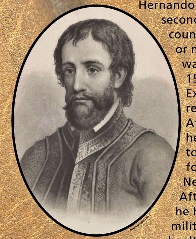
Hernando de Soto, second son of a country hidalgo, or minor noble, was born around 1500 in the Extremadura region of Spain. At age 13, he left home to seek his fortune in the New World. After proving he had . . . — — Map (db m126567) HM
Near Desoto Memorial Highway (75th Street NW), 0.2 miles north of 24th Avenue NW when traveling north.
Born of Nomads
The early peoples of the Americas were descended from nomadic tribes that arrived during the last Ice Age—more than 12,000 years ago. Florida’s climate resembled that of savannah Africa. Early hunters tracked mastodons, . . . — — Map (db m126568) HM
Near Interstate 275, 2.5 miles north of Terra Ceia Road, on the right when traveling north.
Bountiful Waters
Early peoples living along the warm waters of this coast harvested the vast bounty of the Gulf of Mexico and surrounding lands. They built villages with intricate canals, lagoons, and mounds made of shell and earth. Early . . . — — Map (db m126565) HM
Near Interstate 275, 2.5 miles north of Terra Ceia Road, on the right when traveling north.
A Name for Himself
On May 29, 1539, Hernando de Soto’s fleet of 9 ships passed here, carrying over 700 men, as well as women, children, and slaves. For De Soto, this was the realization of a long-awaited dream. In 1533, after participating . . . — — Map (db m126564) HM
On Gulf City Road, 0.2 miles north of Cockroach Bay Road, on the left when traveling north.
It’s May 30, 1539…
Spanish conquistador Hernando de Soto has arrived here in La Florida, Land of Flowers, and stepped ashore –
My men can now offload our nine ships. We have sailed with 500 tons of materials needed for our . . . — — Map (db m126569) HM
On E.G. Simmons Park Drive, 3.2 miles west of South Tamiami Trail (U.S. 41).
(Left panel)
De Soto Trail
1539-1540
You are standing along the historic route of the conquistador Hernando de Soto and his expedition through the Florida Native American territories in his quest for gold and glory. . . . — — Map (db m126570) HM
Near McMullen Road, 0.9 miles south of Boyette Road, on the left when traveling south.
It’s June 20, 1539…
Juan Ortiz, a lost Spaniard from an earlier expedition with Pánfilo de Narváez, is found by De Soto’s men not far from here. He tells his story –
Ten years ago I was captured by Chief Ucita. I later escaped to the . . . — — Map (db m126571) HM
Near Winter Garden Vineland Road (County Road 535) 6 miles north of Interstate 4 (State Road 400), on the right when traveling north.
It’s July 17, 1539…
Hernando de Soto’s army has moved further north to the shores of this large lake –
We have decided to name the lake St. John. Those of us in the cavalry have just returned from scouting ahead. We searched the . . . — — Map (db m126572) HM
On South Avenue east of Depot Lane, on the right when traveling east.
It’s July 18, 1539…
Hernando de Soto’s army has crossed the nearby grasslands they call the green desert –
We could find no water in this lush green environment. Due to the intense summer sun, many of our men have succumbed to heat . . . — — Map (db m126573) HM
On Bougainvillea Avenue at 7th Street (U.S. 98), on the left when traveling west on Bougainvillea Avenue.
It’s July 19, 1539…
Conquistador Hernando de Soto’s army has turned northward –
We have found several Indian villages in this area. Many are abandoned but stocked full of harvested corn.
”The next day they came to the . . . — — Map (db m126566) HM
Near Richloam Clay Sink Road, 0.1 miles east of Riverland Road, on the right when traveling east.
It’s July 20, 1539…
Here at the Indian village called Luca, Calvary Captain Baltasar de Gallegos reports back to Hernando de Soto –
My mission to meet with the great Chief Urriparacoxi was unsuccessful. The chief hid in the . . . — — Map (db m126574) HM
Near Lake Lindsey Road (County Road 476) 0.1 miles east of Lingle Road (County Road 439), on the left when traveling east.
It’s July 23, 1539…
Conquistador Hernando de Soto and his advance guard of 12 horsemen have just passed the small Indian village of Vicela…
I have decided not to stop here. We must press on further north and reach the chiefdom of . . . — — Map (db m126575) HM
On East Orange Avenue / South Duval Island Drive east of South Shore Acres Point, on the right when traveling east.
It’s July 24, 1539…
Hernando de Soto’s army has set up camp at a nearby Indian village, Tocaste -
I moved ahead with a small scouting party. Just north of the village, we discovered a broad road, which I believe may be the entrance . . . — — Map (db m126576) HM
Near East Dampier Street east of North Mill Avenue when traveling east.
It’s July 25, 1539…
Captain Moscoso is leading Hernando de Soto’s army north, from the village of Tocaste, to support De Soto’s scouting party…
Passing near a large lake, we were met by messengers sent by De Soto. They told us the . . . — — Map (db m126577) HM
Near East Turner Camp Road (County Road 581) at Parker Street, on the right when traveling north.
It’s July 26, 1539…
An advance guard of Hernando de Soto’s army has moved through a nearby area and crossed the present-day Withlacoochee River -
It took us two days to cross the river. The rest of our army soon followed. Weighed . . . — — Map (db m126578) HM
Near State Road 200, 1.5 miles south of County Road 484, on the left when traveling south.
It’s July 29, 1539…
De Soto’s weary and starving army arrives at the village of Ocale -
We found the village abandoned but full of food and supplies. I ordered my men to rest and then gather enough provisions for the next several . . . — — Map (db m126579) HM
On County Road 337, 0.8 miles south of State Road 121, on the right when traveling south.
It’s August 11, 1539…
Hernando de Soto has taken a small force of 60 cavalry and 100 foot soldiers north through Timucuan territory towards the land of the Apalachee -
I have entrusted Captain Moscoso to lead the army north, while I . . . — — Map (db m126580) HM
On NW 83rd Street north of North West South Road, on the left when traveling north.
It’s August 13, 1539…
Hernando de Soto and his scouting party are passing through the Indian villages of Utinamocharra located just south of here –
My army of more than 700 men follow behind. We will march quickly through . . . — — Map (db m126581) HM
Near SE Oleno Park Road, 2 miles east of US Highway 41 (U.S. 441) when traveling east.
It’s August 15, 1539…
Hernando de Soto and his scouts arrive at the Indian village of Cholupaha. It lies along the present-day Santa Fe River, which runs through here –
My Men captured several Indians and questioned them . . . — — Map (db m126582) HM
Near SW Elim Church Road (County Road 238) 0.2 miles east of SW Ichetucknee Avenue, on the right when traveling east.
It’s August 17, 1539…
When Hernando de Soto’s scouts sight the abandoned Indian village of Caliquen, Cavalry Captain Baltasar de Gallegos is ordered to move ahead –
My men and I were sent to check for food and supplies. When . . . — — Map (db m127006) HM
On Northwest Falling Creek Road (County Road 131) 0.9 miles north of US Highway 41 (State Road 100), on the right when traveling north.
It’s September 10, 1539…
Conquistador Hernando de Soto has come to Uriutina, a deserted Indian village near here.
We have feasted upon the bounty of food left behind by the fleeing villagers. Messengers sent by Chief Uzachile have . . . — — Map (db m126584) HM
On Camp Weed Place, 0.1 miles west of 75th Drive, on the right when traveling west.
It’s September 12, 1539…
Hernando de Soto’s army has stopped at a small abandoned village not far away –
We have been forced to remain in this village for three days now. Torrential rains have halted our progress. We will remember . . . — — Map (db m126585) HM
Near Silas Drive SW, 0.3 miles east of Irvin Avenue NW (State Road 51), on the right when traveling east.
It’s September 15, 1539…
Hernando de Soto and his army have arrived at the nearby village of Napituca. His interpreter, Juan Ortiz, later recounts –
Upon our arrival, De Soto met with several chiefs who demanded the release of . . . — — Map (db m126586) HM
On SE Boundary Bend Trail, 2.8 miles east of County Road 255, on the left when traveling east.
It’s September 23, 1539…
Conquistador Hernando de Soto and his men have reached a large river, the present-day Suwannee –
My nose is broken, and we are weary from battle. We will rest here for two days before crossing. Envoys of . . . — — Map (db m126587) HM
On Desoto Park Drive south of East Lafayette Street, on the left when traveling south.
On September 30, 1539…
Hernando de Soto’s army crossed into the land of the Apalachee. Its borders ran from southern Georgia to the Gulf of Mexico, and from the Aucilla River to the waters of the Ochlockonee.
A Complex Culture
Part of . . . — — Map (db m126588) HM
On West Washington Street west of Mahan Drive, on the right when traveling west.
It’s October 3, 1539…
Hernando de Soto’s army has crossed a large swamp to the east of here and is attacked by Apalachee warriors –
Our cavalry proved useless against this attack, as the trails are too narrow. We were forced to . . . — — Map (db m126590) HM
Near Heritage Park Boulevard east of Parkview Drive when traveling east.
It’s October 5, 1539
Hernando de Soto’s army has reached the nearby village of Calahuchi -
We passed through fertile lands covered in large fields of corn - maize. While we marched, Apalachee warriors moved through the . . . — — Map (db m126589) HM
On Desoto Park Drive south of East Lafayette Street, on the left when traveling south.
It’s October 6, 1539…
Hernando de Soto established his winter encampment here, at Anhayca, a principal Apalachee Village
”On Sunday, October 25, [De Soto] arrived at a town called Uzela, and on Monday, at Anhayca Apalachee . . . — — Map (db m126591) HM
On Woodville Highway (State Road 363) 0.3 miles south of Capital Circle Southeast (U.S. 319), on the right when traveling south.
It’s October 11, 1539…
Near here, Captain Juan Añasco of Hernando de Soto’s army has entered the Apalachee village of Aute -
The village is deserted, but we have found a small supply of corn. My men captured several Indians. One is . . . — — Map (db m126592) HM
Near Old Woodville Road, 0.2 miles south of Cumberland Trace (South Springwood Boulevard), on the right when traveling south.
It’s October 11, 1539…
Hernando de Soto and his army have stopped for the winter at the village of Anhayca, just north of here. Low on supplies, De Soto has dispatched his trusted Captain, Juan de Añasco…
As we are desperate for . . . — — Map (db m126593) HM
On Riverside Drive, 0.1 miles west of Port Leon Drive (State Road 363), on the left when traveling west.
It’s October 16, 1539…
In searching this area for a usable harbor, Hernando de Soto’s captain Juan de Anasco has found evidence of Pánfilo de Narváez’ expedition of 1528…
In an overgrown clearing, we have discovered many horse skulls and . . . — — Map (db m126594) HM
Near East Main Street (County Road 196) at South Alcaniz Street, on the right when traveling east.
(Left panel)
De Soto Trail
1539-1540
You are standing along the historic route of the conquistador Hernando de Soto and his expedition through the Florida Native American territories in his quest for gold and glory. . . . — — Map (db m126595) HM
Near Iamonia Landing Road, 1.2 miles south of County Highway 12, on the left when traveling south.
On March 3, 1540…
Led by Hernando de Soto, the army departed these Apalachee lands to continue their expedition northward. They crossed the present-day Flint River and then traversed the Mississippi River several times –
From here, . . . — — Map (db m126596) HM