Marker Logo HMdb.org THE HISTORICAL
MARKER DATABASE
“Bite-Size Bits of Local, National, and Global History”


31 entries match your criteria.  


Related Historical Markers

Surrender at Appomattox Virtual tour by markers.
 
Appomattox Court House Marker image, Touch for more information
By Brandon D Cross, June 7, 2016
Appomattox Court House Marker
SHOWN IN SOURCE-SPECIFIED ORDER
1 Virginia, Appomattox County, Appomattox — K-158 — Appomattox Court HouseNew and Old
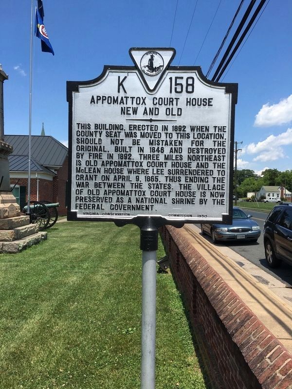
On Court Street (Virginia Route 131) at Morton Lane, on the right when traveling south on Court Street.
2 Virginia, Appomattox County, Appomattox — MG-2 — The Last Positions
On Virginia Route 26 at County Route 677, on the right when traveling south on State Route 26.
3 Virginia, Appomattox County, Appomattox — Grant’s Pursuit
On Old Courthouse Road (Virginia Route 24), on the left when traveling west.
4 Virginia, Appomattox County, Appomattox — “Message of Peace”
On Old Courthouse Road (Virginia Route 24), on the left when traveling west.
5 Virginia, Appomattox County, Appomattox — Raine Cemetery and Monument
On Old Courthouse Road (Virginia Route 24), on the left when traveling west.
6 Virginia, Appomattox County, Appomattox — Raine Memorial
On Old Courthouse Road (Virginia Route 24), on the left when traveling west.
7 Virginia, Appomattox County, Appomattox — Sears Lane
On Old Courthouse Road (State Highway 24), on the right when traveling east.
8 Virginia, Appomattox County, Appomattox — MG-1 — Appomattox Court House Confederate Cemetery
On Old Courthouse Road (Virginia Route 24), on the right when traveling west.
9 Virginia, Appomattox County, Appomattox — A Strategic DelayAppomattox Court House Nat’l Hist Park
On Old Courthouse Road (Virginia Route 24), on the right when traveling west.
10 Virginia, Appomattox County, Appomattox — North Carolina
On Old Courthouse Road (Virginia Route 24), on the right when traveling west.
11 Virginia, Appomattox County, Appomattox — Appomattox
On Appomattox Court House NHP entrance road, on the right when traveling north.
12 Virginia, Appomattox County, Appomattox — Confederate Cemetery
On Old Courthouse Road (Virginia Route 24), on the right when traveling west.
13 Virginia, Appomattox County, Appomattox — Wartime LandscapeAppomattox Court House National Historical Park — National Park Service —
Near Old Courthouse Road (Virginia Route 24), on the right when traveling west.
14 Virginia, Appomattox County, Appomattox — Appomattox Court House
On National Park Drive (State Highway 24), on the right when traveling north.
15 Virginia, Appomattox County, Appomattox — McLean House
On Richmond-Lynchburg Stage Road, on the left when traveling west.
Paid Advertisement
16 Virginia, Appomattox County, Appomattox — Clover Hill Tavern
Near National Park Drive (State Highway 24), on the right when traveling west.
17 Virginia, Appomattox County, Appomattox — Last Artillery Shots
On Price Edward Court House Road at Richmond-Lynchburg Stage Road, on the right when traveling north on Price Edward Court House Road.
18 Virginia, Appomattox County, Appomattox — Final Combat
On George Peers Drive (State Highway 24), on the right when traveling west.
19 Virginia, Appomattox County, Appomattox — The Surrender Ceremony
On George Peers Drive (State Highway 24), on the right when traveling west.
20 Virginia, Appomattox County, Appomattox — Lee and Grant MeetAppomattox Court House National Historical Park — National Park Service, U.S. Department of the Interior —
On Richmond-Lynchburg Stage Road, on the left when traveling east.
21 Virginia, Appomattox County, Appomattox — “Salute of Arms”
On Richmond-Lynchburg Stage Road, on the right when traveling east.
22 Virginia, Appomattox County, Appomattox — Grant and Lee Meeting
On Richmond-Lynchburg Stage Road, on the left when traveling east.
23 Virginia, Appomattox County, Appomattox — Appomattox River
Near Old Courthouse Road (Virginia Route 24), on the right when traveling west.
24 Virginia, Appomattox County, Appomattox — Lee's Apple Tree
On Old Courthouse Road (State Highway 24), on the right when traveling east.
25 Virginia, Appomattox County, Appomattox — After the Surrender
On Old Courthouse Road (Virginia Route 24), on the right when traveling west.
26 Virginia, Appomattox County, Appomattox — Historic Vegetation1865
On Old Courthouse Road (State Highway 24), on the right when traveling east.
27 Virginia, Appomattox County, Appomattox — Confederates TrappedAppomattox Court House Nat’l Hist Park
On Old Courthouse Road (Virginia Route 24), on the left when traveling west.
28 Virginia, Appomattox County, Appomattox — Lee’s Last Headquarters
On Old Courthouse Road (Virginia Route 24), on the left when traveling west.
29 Virginia, Appomattox County, Appomattox — ANV Headquarters
Near Old Courthouse Road (Virginia Route 24), on the left when traveling west.
30 Virginia, Appomattox County, Appomattox — K-157 — Surrender at Appomattox
On Richmond Highway (U.S. 460) 0.6 miles east of Police Tower Road (Virginia Route 613), on the right when traveling east.
31 Virginia, Appomattox County, Appomattox — K-156 — The Last Fight
On Richmond Highway (U.S. 460) 0.6 miles east of Police Tower Road (Virginia Route 613), on the right when traveling east.
Paid Advertisement
 
 
CeraNet Cloud Computing sponsors the Historical Marker Database.
This website earns income from purchases you make after using our links to Amazon.com. We appreciate your support.
Paid Advertisement
May. 21, 2024