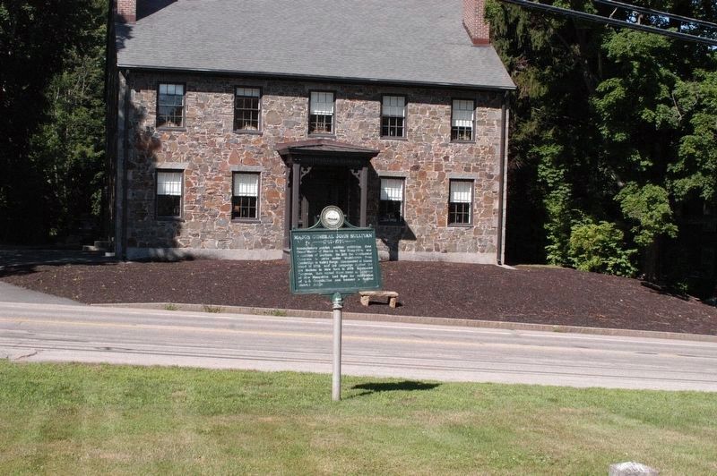
On Newmarket Road (New Hampshire Route 108), on the left when traveling west.
Revolutionary patriot, soldier, politician, first Grand Master of Masons in New Hampshire, and a resident of Durham. He left the Continental Congress to serve under Washington from Cambridge to Valley Forge. Commanded at Rhode Island in 1778, and . . . — — Map (db m96438) HM
Indian Castle
Located near junction of
Castle Creek with Chenango
River. Called Otsiningo.
Destroyed Aug. 18, 1779
during Sullivan Campaign — — Map (db m93030) HM
Near This Point 18 August 1779
Camped the army of James Clinton en
route to join the forces of General John
Sullivan in the expedition against the Iroquois and their British allies in the war of
the American Revolution
Originally erected by . . . — — Map (db m92920) HM
A museum exhibit interprets the Sullivan-Clinton Campaign of 1779. The campaign destroyed Native American villages and crops throughout the Iroquois homeland. — — Map (db m94628) HM
Routes of the Armies of General John Sullivan and General James Clinton 1779
An expedition against the hostile Indian nations which checked the aggressions of the English and Indians on the frontiers of New York and Pennsylvania, extending . . . — — Map (db m93324) HM
On West Main Street (Route 17C) at Badger Avenue, on the right when traveling west on West Main Street.
An expedition against the hostile Indian nations which checked the aggressions of English and Indians on the frontiers of New York and Pennsylvania, extending westward the dominion of the United States.
Rear Face:
Union near this point . . . — — Map (db m141807) HM
On Main Street (New York State Route 90) 0.5 miles north of Sherwood Road (County Route 42A), on the right when traveling north.
front face
An expedition against the hostile Indian nations which checked the aggressions of the week English and Indians on the frontiers of New York and Pennsylvania, extending westward the dominion of the United States. rear . . . — — Map (db m145844) HM
On Route 90, 0.1 miles south of Town Line Road (County Route 4A), on the left when traveling south.
Here where the Great Iroquois Trail
turned east, there passed on the 21st day of
September, 1779, Lieutenant-Colonel William
Butler's force of 600 men from Major-General
John Sullivan’s army, on their march to the
Cayuga castle on the Great . . . — — Map (db m145775) HM
On Railroad Street at Lake Road, on the right when traveling south on Railroad Street.
Routes of the General John Sullivan and General James Clinton
1779
An expedition against the hostile Indian Nations which checked the aggressions of the English and Indians on the frontiers of New York and Pennsylvania, extending westward the . . . — — Map (db m143350) HM
On New York State Route 90, 0.1 miles north of Great Gully Road, on the left when traveling south.
front face
An expedition against the hostile Indian nations which checked the aggressions of the English and Indians on the frontiers of New York and Pennsylvania, extending westward the dominion of the United States.
rear face . . . — — Map (db m145834) HM
On 1547 County Road 60 (County Route 60) west of Interstate 86, on the right when traveling east.
General Sullivan's troops were attacked by Indians posted on this ridge. A valorous charge led by Colonel Hubley drove the Indians to the swamp a quarter mile west. The American dead were conveyed to Tioga and buried at Fort Sullivan.
(Reverse . . . — — Map (db m66976) HM
The climactic battle of the Sullivan-Clinton campaign occurred here as approximately 5,000 soldiers defeated a British force of Native Americans, Loyalists, and regulars. — — Map (db m33545) HM
Congress and General George Washington planned a major offensive campaign against the Seneca, Cayuga, and loyalists in 1779. Washington chose Major General John Sullivan to lead the expedition up the Susquehanna River, while Brigadier General . . . — — Map (db m33547) HM
On Oneida Road (County Route 60) at County Route 8, on the left when traveling west on Oneida Road.
The 1779 campaign drove
native peoples from their
villages. Seneca and Delaware
fought to protect their
family, homes and way of life. — — Map (db m243110) HM
On Oneida Road (County Route 60) near County Route 8, on the left when traveling west.
The Seneca and Delaware urged
British allies to help block
Continental troops advance
resulting in Battle of
Newtown on August 29, 1779. — — Map (db m243111) HM
About two miles down The Susquehanna River on an island and adjacent shores was the camp site of the army of General James Clinton on the night of August 13, 1779. The site of Afton was occupied by the Indian village of Conihunto Destroyed by a . . . — — Map (db m93323) HM
Routes of the Armies of
General John Sullivan
and General
James Clinton
1779
An expedition against the hostile Indian nations which checked the aggressions of the English and Indians on the frontiers of New York and Pennsylvania, extending . . . — — Map (db m92996) HM
On U.S. 7 at Kelly Road, on the right when traveling north on U.S. 7.
Routes of the Armies of
General John Sullivan
and
General James Clinton
1779
An expedition against the hostile Indian nations which checked the aggressions of the English and Indians on the frontiers of New York and Pennsylvania, extending . . . — — Map (db m92998) HM
On Footes Corners Road at South Livonia Road (New York State Route 15), in the median on Footes Corners Road.
Routes of the Armies of General John Sullivan and General James Clinton 1779. An expedition against the hostile Indian nations which checked the aggressions of the English and Indians on the frontiers of New York and Pennsylvania, extending westward . . . — — Map (db m218832) HM
Near Cuylerville Road (U.S. 20A) 0.2 miles west of Barrett Road.
or Little Beard's Town
De-O-Nun-Da-Ga-A
(Where the Hill is Near)
This principal village of the Senecas was destroyed in 1779 and was the farthest point reached by General John Sullivan and an army of four thousand men acting under direct . . . — — Map (db m58056) HM
On Cuylerville Road (U.S. 20A) 0.2 miles west of Barrett Road.
Routes of the Armies
of General John Sullivan and General James Clinton 1779
An expedition against the hostile Indian nations which checked the aggressions of the English and Indians of the frontier of New York and Pennsylvania, extending westward . . . — — Map (db m58058) HM
Near David Gray Hill Road, 0.8 miles east of Barber Hill Road.
Sacred to the memory of Lieut. Thomas Boyd and Sergt. Michael Parker who were captured and afterward tortured and killed. ——————— Afar their bones may lie, but here their patriot blood baptized the . . . — — Map (db m117006) HM WM
Near David Gray Hill Road, 0.8 miles east of Barber Hill Road.
Groveland Ambuscade Park During the Clinton-Sullivan Campaign in September 1779, Lt. Thomas Boyd's scouting party was ambushed by Tories and Indians on this site. Sixteen Revolutionary War soldiers died here. Revolutionary War Heritage Trail . . . — — Map (db m117005) HM
On Rix Hill Rd, 0.3 miles west of New York State Route 15A, on the left when traveling west.
An expedition against the hostile Indian nations which checked the aggressions of the English and Indians on the frontiers of New York and Pennsylvania extending westward the dominion of the United States. — — Map (db m168896) HM
Near Wilson Boulevard at Elmwood Avenue, on the right when traveling west.
Empires in America After Christopher Columbus discovered America in 1492, European invaders claimed it for themselves. By the middle of the eighteenth century, France, England, and Spain claimed possession of most of the North American . . . — — Map (db m131876) HM
Near Mount Hope Blvd., 0.2 miles north of Elmwood Avenue.
Capt-Lieut. Thomas Boyd, Sergeant Michael Parker, Sergeant Nicholas Hungerman, Sergeant William Floyd, Corporal Calhoun, Oneida Lt. Honyost Thaosagwat
and nine volunteer riflemen, John Conrey, Benjamin Curtin, James McElroy, William . . . — — Map (db m70895) HM WM
An expedition against the hostile Indian nations which checked the aggressions of English and Indians on the frontiers of New York and Pennsylvania, extending westward the dominion of the United States. — — Map (db m130975) HM
On Lakeshore Drive at City Pier, on the right when traveling south on Lakeshore Drive.
An expedition against the hostile Indian nations which checked the aggressions of the English and Indians on the frontiers of New York and Pennsylvania, extending westward the dominion of the United States — — Map (db m61893) HM
On New York State Route 14 at Kashong Point Road, on the right when traveling north on State Route 14.
An expedition against the hostile Indian nations which checked the aggressions of the English and Indians on the frontiers of New York and Pennsylvania, extending westward the dominion of the United States. — — Map (db m68624) HM WM
Rivers and streams flowing southward make this area a part of the great Susquehanna River Valley. Early fur traders from the Mohawk Valley dealt with Indians as far away as Oquaga(Now Windsor). Large colonial land grants were obtained by George . . . — — Map (db m98343) HM
On New York State Route 14 south of Jackson Hill Road (County Route 14), on the right when traveling south.
A village of the Senecas destroyed by a
Continental Army under General John Sullivan
British and Indians defeated at the
battle of Newtown, August 29, 1779,
retreated to this place where a two days'
war council resulted in abandonment . . . — — Map (db m246794) HM
On New York State Route 14 south of Jackson Hill Road, on the right when traveling south.
An expedition against the hostile Indian nations
which checked the aggressions of the English and Indians
on the frontiers of New York and Pennsylvania, extending
westward the dominion of the United States. — — Map (db m246796) HM
On New York State Route 89, 0.2 miles south of Lower Lake Road, on the left when traveling south.
Site of
"a very pretty Indian town
of ten houses"
Burned September 21, 1779
————————
See page 76 "Journals of the
Military Expedition of
Major General John Sullivan,"
published by the . . . — — Map (db m104763) HM
On Rhodes Road just west of New York State Route 414, on the right when traveling west.
An expedition against the hostile Indian nations which checked the aggressions of the English and Indians on the frontiers of New York and Pennsylvania, extending westward the dominion of the United States. — — Map (db m68621) HM WM
On New York State Route 96, 1 mile south of Potter Road, on the left when traveling south.
Sullivan Trail Before settlement by white men, Col. Henry Dearborn of the Sullivan Expedition viewed Cayuga Lake here Sept. 22, 1779. — — Map (db m96336) HM
On New York State Route 89 at Swick Road, on the left when traveling north on State Route 89.
Degory Prowtt Drummer Boy, 1776 - 1783, at siege of Fort Stanwix on the Sullivan Expedition, at surrender of Cornwallis, lived a mile west of here. — — Map (db m96347) HM
On New York State Route 96A, 0.2 miles north of Baptist Church Road.
An expedition against the hostile Indian nations which checked the aggressions of the English and Indians on the frontiers of New York and Pennsylvania, extending westward the dominion of the United States.
Erected by the State of New York 1929 — — Map (db m68623) HM WM
On U.S. 20 at Gravel Road (County Route 101), on the left when traveling north on U.S. 20.
Routes of the armies of
General John Sullivan
and
General James Clinton
1779
An expedition against the hostile Indian nations which checked the aggression of the English and Indians on the frontiers of New York and Pennsylvania, . . . — — Map (db m8069) HM
On West Main Street (U.S. 20) 0.1 miles west of Park Place, on the right when traveling west.
Routes of the armies of
General John Sullivan
and
General James Clinton
1779
An expedition against the hostile Indian nations which checked the aggression of the English and Indians on the frontiers of New York and Pennsylvania, . . . — — Map (db m8193) HM
On U.S. 20, 0.1 miles west of Park Place, on the right when traveling west.
This monument was erected in
September 1879. To commemorate
The destruction of the Indian village
SKOI-YASE,
By Col. John Harper, under orders of
Maj. Gen John Sullivan,
September 8, 1779. — — Map (db m8192) HM
On Southern Tier Expressway (Interstate 86) 0.8 miles west of Victory Highway (State Route 417), on the right when traveling west.
This part of New York State was once the homeland of the Seneca Indians, one of the six nations of the Iroquois Confederacy. These people were great agriculturalists, known for their corn, beans, squash, fruit trees and livestock. During the . . . — — Map (db m222465) HM
On West Main Street (Route 96) at Washington Street, on the right when traveling west on West Main Street.
Sullivan expedition 1779 The campaign severed the English-Indian Alliance and checked English aggression of our western frontier — — Map (db m224421) HM
On South Main Street (State Highway 199), on the right when traveling north.
Indian village 3 miles distant from Sheshecunnuck Site of Sullivan's Army Encampment August 11-26, 1779 Lay one and one fourth miles south of this point — — Map (db m32912) HM
On Grand Army of the Republic Hwy (US 6) at Moravian Road on Grand Army of the Republic Hwy (US 6).
Wyalusing
10 1/2 miles from Vanderlip's farm. Fifth encampment of Sullivan's Army on the march from Wyoming to Teaoga, August 6-7, 1779, was on site just west of this road marked by the Moravian Indian Town Monument — — Map (db m90560) WM
On Grand Army of the Republic Hwy (U.S. 6) at Moravian Road, on the right when traveling east on Grand Army of the Republic Hwy.
Gen. John Sullivan's army camped just west Aug. 5-7, 1779, en route to attack the New York Iroquois. A major campaign, destroying 40 villages and ending the Indian-Tory frontier menace. — — Map (db m90562) WM
The Lime Hill Battlefield, April 14th, 1782. Several hundred yards south west and in front of this marker, a rescue party of eight Patriot men ambushed a war party of thirteen Iroquois Indians who were marching five captives, Mrs. Roswell Franklin . . . — — Map (db m90496) WM
This stone commemorates the passing through Wesauking on August 9, and October 4, 1779 of Major General John Sullivan and his troops in the military expedition against the Six Nations.
“The glorious achievements we have exhibited in . . . — — Map (db m90344) WM
Standing Stone-9 ½ miles from Wyalusing. Sixth encampment of Sullivan’s Army on the march from Wyoming to Teaoga August 8-9 1779 was on river lowlands opposite the Standing Stone. — — Map (db m90362) WM
Gen. John Sullivan's army camped on the nearby river lowlands Aug. 8-9, 1779 en route to attack the Six Nations Iroquois. Sixth camp between Wyoming and Fort Sullivan. — — Map (db m90364) WM
On Pennsylvania Route 940, on the right when traveling west.
General John Sullivan’s 1779 Revolutionary War expedition built a road through this area. Only one bridge was required from Easton to Wilkes-Barre, and it crossed Tobyhanna Creek here. Camped nearby, over 500 troops completed the difficult . . . — — Map (db m103664) HM
On Sullivan Trail (Pennsylvania Route 4004) 0.5 miles south of PA Route 940 (Pennsylvania Route 940) when traveling north.
This encampment site was named by General Sullivan’s Expedition of the Revolutionary War, 1779, en route north to avenge the Wyoming Massacre. They called the adjacent swamp Hell’s Kitchen. Army engineers built this first road on the Pocono Plateau, . . . — — Map (db m84565) HM
On Sullivan Trail (Pennsylvania Route 4004) 0.5 miles south of PA Route 940 (Pennsylvania Route 940).
So called because of privations suffered by men of 2nd New York and 5th New Jersey Regiments of the Continental Line who encamped here while changing a wilderness trail into a military road to pave the way for Sullivan's Expedition against the . . . — — Map (db m137653) HM
On Hamilton Road East (Bus US 209) at Neola Road on Hamilton Road East (Bus US 209).
Site of the Sullivan Stores the advance post of the Expedition
Marked by
The Pennsylvania Historical Commission
And the Valley Forge Chapter SAR
1929 — — Map (db m137665) HM
On Manor Drive (PA 611) at T 537 on Manor Drive (PA 611).
Learned's Tavern marked the end of the second day's march from Easton to Fort Wyoming, at Wilkes-Barre. The army camped here June 19, 1779, after a 16-mile march from Heller's Tavern. — — Map (db m86935) HM
In July 1779, General John Sullivan began the southern leg of one of the largest offensive campaigns of the Revolutionary War. Directed against the Indian warriors of the six nations and their British and Loyalist allies, Sullivan’s march proceeded . . . — — Map (db m86229) WM
On Sullivan Road west of West Campus Lane, on the left when traveling west.
This stone marks the road over
which General John Sullivan
marched June 18, 1779, to quell
the Indian insurrection and
avenge the Wyoming Massacre
—————
Erected by the
George Taylor Chapter
Daughters . . . — — Map (db m136117) HM
On Roosevelt Highway (US 6) at Blue Stone Road on Roosevelt Highway (US 6).
Fourteen miles from Tunkhannock, Fourth Encampment of Sullivan's Army, on the march from Wyoming to Teaoga August 4-5, 1779, lay on this lowland known as blade Walnut Flats. — — Map (db m90564) HM
On Sullivan Trail (Pennsylvania Route 92) at Lowry Lane, on the right when traveling north on Sullivan Trail.
Gen. John Sullivan's army camped on the lowland on the opposite side of the river Aug. 1-2, 1779. It was the second camp from Fort Wyoming at Wilkes-Barre en route to Tioga. — — Map (db m90606) WM
On West Tioga Street (BUS US 6) at Warren Street on West Tioga Street (BUS US 6).
Tunkhannock
Twelve miles from Quialutimack
on the march from Wyoming to Teaoga
August 3, 1779
lay on lowlands between this point and the river
— — Map (db m190125) WM