1005 entries match your criteria. Entries 201 through 300 are listed.⊲ Previous 100 — Next 100 ⊳
Montana National Register Sign Program Historical Markers
Aluminum plaques "Listed in the National Register of Historic Places by the United States Department of the Interior in cooperation with the Montana Historical Society."
On East Park Avenue (State Highway 1) near Chestnut Street, on the left when traveling east.
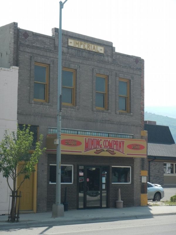
The Imperial Meat Market specialized in fresh meat, sausage, game, fish, and oysters when D. D. Walker and Israel Gibbs opened it in a wood-frame building on this lot in 1889. Shop foreman Albert Bourbonniere, in partnership with Big Hole Valley . . . — — Map (db m183451) HM
On Main Street near West 5th Street, on the left when traveling north.
Alice and George Winston were among the first residents of the Main Street neighborhood south of Anaconda’s business district. The Anaconda Weekly Review noted in August of 1888 that the Winstons’ fine home was well under construction. A lovely . . . — — Map (db m205801) HM
On East Park Avenue (State Highway 1) at Chestnut Street, on the left when traveling east on East Park Avenue.
Until the arrival of large discount grocery chains after World War II, numerous grocery businesses thrived in Anaconda. Some merchants sold a vast array of goods, and others specialized in dry goods, produce, or meat. Many groceries catered to . . . — — Map (db m183453) HM
On Main Street at Park Avenue, on the right when traveling north on Main Street.
Marcus Daly and W. L. Hoge founded Anaconda’s first bank in 1883. Hoge, Anaconda’s first mayor, sold his interest in the bank to Daly in 1895. The institution became the Marcus Daly & Company Bank and later, the First National Bank of Anaconda. . . . — — Map (db m180837) HM
On Oak Street at East Third Street, on the right when traveling north on Oak Street.
Itinerant circuit riders brought Methodism to this part of Montana as early as 1880. Anaconda’s first Methodist church was built in 1884, but its small band of followers had scattered by the time Reverend Philip Lowry was assigned here in 1889. He . . . — — Map (db m205793) HM
On Main Street (State Highway 1) near East Park Avenue, on the right when traveling north.
Thomas Silha and sisters Mary Vollenweider and Margaret Morse hired architect Joseph White to design this commercial/residential building in 1911. The $20,000 brick building originally featured identical storefronts with glass display windows topped . . . — — Map (db m183391) HM
On East Park Avenue (State Highway 1) near Oak Street, on the left when traveling east.
After building the St. Jean Block next door in 1893, Dr. Felix St. Jean again hired respected Anaconda mason John Cosgrove to build this annex building in 1897. Cosgrove, an old friend of Marcus Daly’s, also built the foundations of the Upper Works . . . — — Map (db m183525) HM
On East Park Avenue (State Highway 1) near Oak Street, on the right when traveling east.
Prosperous Deer Lodge Valley rancher George Parrot invested $13,000 to build the Parrot Block in 1896. The first story of this well-appointed Queen Anne style commercial and boardinghouse building originally featured tall, plate-glass display . . . — — Map (db m183394) HM
On Main Street near Park Avenue, on the right when traveling north.
Wholesale liquor dealer John V. Collins commissioned this handsome Renaissance Revival style commercial and boardinghouse building in 1897. The store was home to several saloons during its first twenty years. Workers at Marcus Daly’s Anaconda . . . — — Map (db m180956) HM
On East Park Avenue (State Highway 1) near Cedar Street, on the left when traveling east.
Contractor John Jacobson built this brick store and boardinghouse in 1915, during a time of rapid commercial and residential expansion in Anaconda. Downtown Anaconda property owners developed every square foot of their lots during this boom, . . . — — Map (db m183521) HM
On East Park Avenue (State Highway 1) near Oak Street, on the left when traveling east.
Dr. Felix L. St. Jean and brick mason Joe Cosgrove commissioned local architect Herman Kemna to design this building in 1893. Though later owners remodeled the first-floor façade and renamed the building, the second story remains among the best . . . — — Map (db m183526) HM
On Main Street near West 6th Street, on the left when traveling west.
Anaconda grew quickly after Copper King Marcus Daly established it as his smelter town in 1883, but the community’s Episcopalians needed to wait seven years before they could lay the cornerstone for St. Mark’s Episcopal Church on October 21, 1890. . . . — — Map (db m205796) HM
On East Park Avenue (State Highway 1) near Chestnut Street, on the left when traveling east.
The well-preserved Thorsen Brothers Grocery building is a classic example of an early-twentieth-century commercial building. The decorative brick parapet made the building look larger and offered ample room for signage, while tall display windows . . . — — Map (db m183455) HM
On Hickory Street near West 6th Street, on the right when traveling north.
Mass production of decorative details allowed even modest houses to partake of architectural fashion. In the case of this one-and-one-half-story home, stained glass, gingerbread and latticework, turned porch supports, and fish-scale shingles in the . . . — — Map (db m205808) HM
On East Park Avenue (State Highway 1) at Madison Street, on the left when traveling east on East Park Avenue.
An architecturally impressive landmark and gateway to Anaconda’s east side, the Washoe Brewery symbolizes the private enterprise that flourished in this company town. The imposing Italian Renaissance-inspired brewery with its signature corner tower . . . — — Map (db m205886) HM
On Main Street near East 3rd Street, on the left when traveling south.
Seattle-based theater architect B. Marcus Pinteca (1890-1971) drew the plans for this remarkable structure in 1930. However, the Depression delayed interior finishing and the $200,000 movie theater did not open until 1936. The Washoe Theater and . . . — — Map (db m180981) HM
On East Park Avenue (State Highway 1) near Oak Street, on the left when traveling east.
In October 1900, German tailors William Weiss and John Zilinsky invested in this commercial building. They paid an exorbitant $9,500 for three lots behind Marcus Daly’s bank, where they constructed the first story of this two-story building. Early . . . — — Map (db m183528) HM
On East 3rd Street at Cedar Street, on the left when traveling west on East 3rd Street.
401 East 3rd Street, Anaconda, Montana
Rapidly increasing demand for copper ore in the 1890s brought an influx of more than 5,000 new residents to the Smelter City between 1890 and 1900. To house them all, a fleet of carpenters built hundreds of . . . — — Map (db m205715) HM
On East Park Avenue (State Highway 1) at Cherry Street, on the right when traveling east on East Park Avenue.
Architect Jonathon Barlett designed this marvelous business block as an investment property for T. C. Davidson in 1896. Davidson, an Ohio native and Civil War veteran, came to Montana in 1879. In the early 1890s, Davidson moved from his nearby ranch . . . — — Map (db m183395) HM
On East Commercial Avenue at Main Street, on the left when traveling east on East Commercial Avenue.
After attending Fisk University in Tennessee, Lee Pleasant Driver enlisted in the Twenty-fifth U.S. Colored Infantry in 1888. The twenty-five-year-old private, who soon advanced to corporal, served at Forts Keogh (Miles City) and Missoula. He was . . . — — Map (db m180975) HM
On South Main Street near West Lincoln Avenue, on the left when traveling north.
The completion of the Chicago, Milwaukee, St. Paul, and Pacific Railroad line through this area in 1908 brought an influx of homesteaders, increasing the demand for county services. Simultaneously, the Progressive Movement in Montana sparked a . . . — — Map (db m164216) HM
On Hawthorne Avenue near East Broadway Street, on the left when traveling north.
The Empire Land Company constructed many of Judith Place’s most fashionable residences, including this one- and-one-half-story Craftsman style home circa 1914. Reflecting the Progressive Era’s emphasis on efficiency, the company adopted the . . . — — Map (db m143460) HM
On West Main Street (U.S. 87) near 6th Avenue South, on the left when traveling west.
In March of 1914, four hundred local business owners protested locating Lewistown’s new post office on this site, claiming that the call for bids was not properly advertised. Most favored housing the post office in the Masonic Temple building. . . . — — Map (db m143414) HM
On West Montana Street near 7th Avenue North, on the left when traveling east.
In the 1870s, ranchers and prospectors looking for gold in the Judith Mountains clamored for military protection as they settled a region recently controlled by the Blackfeet. In response, the federal government constructed Fort Maginnis in 1880. . . . — — Map (db m143506) HM
On West Aztec Drive at Stratosphere Drive, on the right when traveling west on West Aztec Drive.
During World War II, the Army Corps of Engineers built almost 1,300 airfields. These rapidly constructed facilities followed standardized plans, all of which included an All Purpose Shop. The unassuming one-story buildings served as the bases' . . . — — Map (db m143570) HM
On West Aztec Drive at Gulf Stream Drive, on the right when traveling west on West Aztec Drive.
Sand-filled “Blue Beetle” practice bombs with a five-pound black powder charge were loaded here for placement in the B-17s’ bomb bays. The practice bombs were later dropped in 1,000-foot circles during the daytime and on lighted targets . . . — — Map (db m143572) HM
On West Main Street (Highway 87) near 7th Street North, on the right when traveling west.
Dr. Frederick F. Attix came to Lewistown in 1901 where he set up one of the first local medical practices. Dr. Attix traveled 70,000 miles in his horse and buggy visiting patients in mining camps, often operating by lamplight in bunkhouses. On April . . . — — Map (db m143417) HM
On East Main Street at 3rd Avenue North, on the left when traveling west on East Main Street.
Kent and Bell, designers of the Montana State Capitol, drew the plans for this Renaissance Revival/Beaux Arts- inspired building of sandstone and brick, completed in 1904. The bank was Lewistown’s first, founded in 1887 by S. S. Hobson, James H. . . . — — Map (db m143365) HM
On Terminal Drive (U-7103) near West Aztec Drive, on the left when traveling north.
Barbed wire encircled this double-compartment storage building and a 24-hour sentry kept armed guard. The top secret Norden bombsight, a mechanical analog computer, was accessed through bank vault doors, removed carefully for training missions, and . . . — — Map (db m143576) HM
On West Main Street (U.S. 87) near 3rd Avenue North, on the right when traveling west.
Built around 1893, the Bon-Ton is one of four remaining pre-1900 masonry structures in the Central Business Historic District. The term bon-ton means “a good or elegant form or style; regarded as fashionably correct.” This structure is . . . — — Map (db m143410) HM
On East Aztec Drive near Rimby Drive, on the left when traveling east.
The United States Army Air Force (USAAF) trained its field maintenance crews in camouflage painting to make aircraft difficult to distinguish from the ground. Constructed in the spring of 1943, this building was designed for teaching and . . . — — Map (db m143595) HM
On West Main Street (U.S. 87) near 7th Avenue North, on the left when traveling west.
Lewistown's first library opened in 1897 with 269 books in a corner of Mary Hanson's millinery shop. When Mrs. Hanson left town two years later, the collection moved to the office of Elizabeth Peeples, county superintendent of schools. In 1905 . . . — — Map (db m143418) HM
On West Main Street (U.S. 87) near 7th Avenue North, on the right when traveling west.
In 1879, Metis—people of French and Chippewa-Cree descent—homesteaded in this area, near the army’s Camp Lewis. Many street names memorialize these settlers, who included Francis A. Janeaux and Paul Morase. But open range cattle . . . — — Map (db m143419) HM
On Gulf Stream Drive near West Aztec Drive, on the right when traveling north.
The mechanics that kept the heavy four-engine bombers, known as “flying fortresses,” aloft and the crew chiefs that coordinated the efforts of their teams had offices in this building. The squadrons that trained at Lewistown, Glasgow, . . . — — Map (db m143574) HM
On Terminal Drive (U-7103) near West Aztec Drive, on the right when traveling north.
The airfield’s immense hangar dominates the flight apron and appears much as it did when World War II vintage B-17s roared down the runway. Construction of the airfield began in July 1942. The original hangar plans were soon modified, increasing the . . . — — Map (db m143591) HM
On West Main Street (U.S. 87) near 2nd Avenue South, on the left when traveling west.
Welsh immigrant Archibald Hopkins settled in central Montana in the 1870s, where he raised produce for sale to local markets. Hopkins watched Lewistown grow from a small trading post to an established community before linking his fortunes to the . . . — — Map (db m143458) HM
On West Main Street (U.S. 87) near 1st Avenue North, on the right when traveling west.
Rubble stone construction with brick veneer became Main Street’s preferred design after 1909. The elegant façade of this business block is an early example of the newer style, constructed before 1911 when locally produced bricks became available. . . . — — Map (db m143459) HM
On West Broadway Street at 8th Avenue North, on the right when traveling east on West Broadway Street.
Two distinct buildings of different origins but with a shared purpose rest companionably side by side on this site today. Pioneer merchant Charles Lehman constructed the handsome stone segment in the 1890s as a rooming house for his unmarried male . . . — — Map (db m143507) HM
On Terminal Drive (U-7103) near West Aztec Drive, on the right when traveling north.
In the dark days following the December 7, 1941, attack on Pearl Harbor, Congress appropriated massive defense appropriations. The US Army selected Great Falls, Montana, as the site of a major air base. Concurrent with its construction were . . . — — Map (db m143590) HM
On East Main Street (U.S. 87) near East Broadway Street.
Rail transportation in the early twentieth century brought homesteaders to Fergus County and cemented Lewistown’s role as a regional commercial center. The General Brokerage Company of Grand Rapids, North Dakota, financed this stunning warehouse for . . . — — Map (db m143355) HM
On West Boulevard Street at 3rd Avenue North, on the left when traveling east on West Boulevard Street.
The seven large residences that comprise Lewistown’s mansion, hence “silk stocking,” district were built during the city’s period of greatest prosperity, from 1904 to 1919. In this small neighborhood, central Montana’s major . . . — — Map (db m143504) HM
On West Main Street (U.S. 87) at 2nd Avenue North, on the right when traveling west on West Main Street.
Constructed during the 1911 half-million-dollar Lewistown building boom, the $20,000 Mackey Building sits directly over Big Spring Creek. A blend of Romanesque and Classical Revival styles, the structure maintains much of its original façade, . . . — — Map (db m143360) HM
On West Main Street (U.S. 87) near 5th Avenue North, on the left when traveling west.
The beautiful blending of brick and handcut stone in this 1905 business block serves as a fine example of Lewistown’s distinctive architecture. Romanesque Revival arches, Renaissance Revival wall layering, and an Italianate cornice speak to the . . . — — Map (db m143413) HM
On West Main Street (U.S. 87) at 3rd Avenue North, on the right when traveling west on West Main Street.
This elaborate six-story brick structure represents a visible sign of the stability and prosperity in Lewistown in 1916 and stands as the architectural anchor of the Central Business District. The construction of this mixed Neoclassical and Revival . . . — — Map (db m143364) HM
On Terminal Drive (U-7103) near West Aztec Drive, on the left when traveling north.
Planning and scheduling of the training missions took place in this one-story T-shaped building during an eleven- month period in 1942-1943. After November 1942, when the first of the four-engine B-17 bombers roared down the airfield, they filled . . . — — Map (db m143575) HM
On West Main Street (U.S. 87) at 4th Avenue North, on the right when traveling west on West Main Street.
One of four remaining pre-1900 masonry structures in the 300 block of Main, this structure at 322 and 324 West Main Street originally housed a restaurant and drug store. “Prescriptions our Specialty” proclaimed an early advertisement for . . . — — Map (db m143411) HM
On West Main Street (U.S. 87) at 3rd Avenue North on West Main Street.
Possibly one of the first architect-designed stone buildings along Main Street, the Power Mercantile Building is the most visible example of Lewistown’s stone architecture. Merchant Francis Janeaux became indebted to supplier T. C. Power and lost . . . — — Map (db m143379) HM
On East Aztec Drive at Stratosphere Drive, on the right when traveling east on East Aztec Drive.
Local businessman Harrison Green established Lewistown’s first airport at this location in 1928, intending to sell it to the city or operate it as a private enterprise. The city, however, established its own airport in 1933 just across the road from . . . — — Map (db m143593) HM
On East Aztec Drive near Rimby Drive, on the left when traveling east.
Caring for the squadrons of men who trained at the airfield was no easy task. It required a permanent host crew of approximately 150 to keep the base running smoothly. In addition to providing the actual training, members of the host crew assured . . . — — Map (db m143596) HM
On West Aztec Drive at Horizon Drive, on the left when traveling west on West Aztec Drive.
Essential for maintaining morality and morale, the Recreation Building was one of the busiest spots on base. A host of activities provided wholesome entertainment to occupy the airmen's off-duty hours. Events included amateur nights on Mondays, . . . — — Map (db m143573) HM
On West Broadway Street at 2nd Avenue North, on the right when traveling west on West Broadway Street.
Lewistown’s first Catholic church was a small frame structure built in 1888. Visiting priests from distant St. Peter’s Mission, Great Falls, and Fort Benton celebrated mass for the French-Canadian, Indian, and settler congregations. The first . . . — — Map (db m143456) HM
On West Main Street (U.S. 87) near 2nd Avenue North, on the left when traveling west.
Lewistown’s population tripled between 1900 and 1910 and the booming building trade attracted stonemasons and craftsmen, many of them Croatian immigrants, who settled here. The upper façade of this 1908 one-story commercial building, revealed during . . . — — Map (db m143363) HM
On 7th Avenue North at West Broadway Street, on the left when traveling north on 7th Avenue North.
Stone buildings constructed by skilled Croatian stonemasons are intrinsic to Lewistown’s unique personality. Peter Tuss, who built this home with Anthony Weingart in 1902, was one such prominent craftsman. Constructed for Citizens’ Electric Company . . . — — Map (db m143505) HM
On East Aztec Drive near Rimby Drive, on the left when traveling east.
During World War II, many aircrews came to Lewistown for the final phase of their training. Here they logged an average eight hours of ground school for every hour of flying time. In this building the men studied aircraft identification, learned . . . — — Map (db m143592) HM
On West Main Street (U.S. 87) near 2nd Avenue North, on the left when traveling west.
Austin W. Warr employed renowned architect John H. Kent—one of the architects for the Montana Capitol Building—to design the Warr Building. Warr organized the Lewistown Telephone Company in 1899. Upon completion of this new office . . . — — Map (db m143359) HM
On West Main Street (U.S. 87) near 3rd Avenue North, on the left when traveling west.
The banner year of 1913 saw close to $1.5 million spent in Lewistown on construction. Two thirds of that sum went toward new, elegant business blocks. The city’s rapid growth—from approximately a thousand people in 1910 to over five thousand . . . — — Map (db m143412) HM
On West Broadway Street near 2nd Avenue North, on the right when traveling west.
As Lewistown’s population doubled between 1910 and 1920, the community found itself short on living space. According to the paper, newcomers had difficulty procuring “even the most indifferent dwelling accommodations.” G. R. Wiedeman . . . — — Map (db m143455) HM
On Swan River Road at Swan Highway (State Highway 83), on the right when traveling north on Swan River Road.
In 1920, the local Rod and Gun Club purchased this acre of land as the site for a community building. Constructed twelve years later, the Swan River Community Hall has served as a locus for valley residents, who gathered here for school functions, . . . — — Map (db m219845) HM
On 2nd Street West at 4th Street West, on the left when traveling south on 2nd Street West.
When twenty-five-year-old housekeeper Cora (Brooks) Moore lived here with her four-year-old son, she owned the home free of mortgage. She built the simple, one-story gable-front home sometime between 1894 and 1899. At that time, it had a back porch . . . — — Map (db m160721) HM
On 4th Avenue East at 5th Street East, on the right when traveling south on 4th Avenue East.
Founded in 1891 by the Great Northern Railway, Kalispell boasted 651 residents in its first year, growing to 2,500 people by 1900. Confident of finding tenants in the booming community, bricklayer John Lundberg built a one- and-one-half story duplex . . . — — Map (db m160390) HM
On 4th Avenue East near 6th Street East, on the right when traveling south.
Slightly arched windows, prominent eave returns, a canted front bay, and decorative shingles reflect the care builders took constructing this one-story home. Retired merchant Jacob Bottorf and his wife Emily resided here from the residence's . . . — — Map (db m160391) HM
On 1st Avenue West at 6th Street East, on the right when traveling south on 1st Avenue West.
A built-in china cabinet with access from two rooms, a bird’s-eye maple floor in the dining room, a breakfast nook with a simple round arch, and an early dishwasher made this stylish 1905 Queen Anne style residence a haven for entertaining. A . . . — — Map (db m160966) HM
On 1st Avenue East at 11th Street East, on the right when traveling south on 1st Avenue East.
Perfect symmetry and mature landscaping make this Colonial Revival style home, built by widow Eliza Elliott circa 1910, quietly inviting. The home initially served as an investment, where retail merchant Peter Iverson and his family were the first . . . — — Map (db m160926) HM
On 5th Avenue East near 6th Street East, on the right when traveling south.
Architect Marion Riffo demonstrated a flair for the dramatic in this grand residence, built in 1910 for State Lumber Company manager David Barber. The home features tall prominent chimneys against a steep, side-gabled roof, which capture the . . . — — Map (db m160210) HM
On 2nd Avenue East near 9th Street East, on the left when traveling south.
Kalispell carpenter Cassius McCarty, property owner from 1909 to 1911, most likely built this vernacular style residence with Craftsman style details. Shortly after construction newlyweds Herbert and Kate Alward moved into the new home. An . . . — — Map (db m160791) HM
On 5th Avenue East at 4th Street East, on the left when traveling south on 5th Avenue East.
Flathead County High School principal Gilbert Ketcham was the first owner of this Craftsman style home built in 1908. As principal from 1902 to 1911, Ketcham was a well-rounded educator who loved being in the classroom. He was called upon to teach . . . — — Map (db m160271) HM
Near 3rd Avenue West near 8th Street West, on the left when traveling south.
Nestled among mature landscaping, this side gabled English-style cottage was home to the Johnson family from the 1940s to 1954. Arthur Louis Johnson came to Montana with his parents and siblings from Ohio during the homestead boom. The family . . . — — Map (db m161104) HM
On 5th Avenue West near 1st Street West, on the right when traveling south.
Carpenter Elmer Bader came to Kalispell from Wisconsin in 1891 to practice his trade. The energetic bachelor purchased two corner lots for $1,000 in 1895 and built two modest residences, one at 521 1st Street West and one at 36 5th Avenue West. In . . . — — Map (db m160666) HM
On 3rd Avenue East at 5th Avenue East, on the left when traveling south on 3rd Avenue East.
Marcus D. Baldwin came to Montana from Ohio in 1885, appointed by President Cleveland as superintendent to the Blackfoot, Blood, and Piegan bands of the Blackfeet tribe in northwestern Montana. Baldwin brought his wife, Sarah, and their two small . . . — — Map (db m160426) HM
On 1st Avenue East near 8th Street East when traveling south.
This narrow front-gabled dwelling was originally one of three identical residences on the half-block built as rentals between 1903 and 1910. Only this example retains the original full-width front porch with hipped roof and turned post supports. . . . — — Map (db m160924) HM
On 1st Street West near 3rd Avenue West, on the right when traveling west.
There were two businesses devoted to automobile repair in Kalispell in 1909, and seven blacksmiths. By 1915, the ratio was almost reversed. Mort Fuller and Harry Jones worked here in one of Kalispell’s three remaining blacksmith shops, while seven . . . — — Map (db m160659) HM
On South Main Street near 1st Street West, on the right when traveling south.
In 1894, the two-year-old Brewery Saloon—then a one-story, twenty-five-by-sixty-foot building—served Kalispell draft beer for five cents a glass. Lunch was free. One of Main Street’s first brick buildings, the saloon featured an oak and mahogany . . . — — Map (db m160658) HM
On 5th Avenue East near 4th Street East, on the left when traveling south.
There were very few homes in the neighborhood when the Reverend O. W. Mintzer built this cross-gabled Queen Anne style landmark in 1894. Although brick was readily available, its wood construction illustrates the local preference of the period. . . . — — Map (db m160329) HM
On 2nd Avenue East near 3rd Street East, on the left when traveling south.
Citizens organized the Kalispell Public Library in 1897 and reorganized it as the Free Library a few years later. Holdings included 772 circulating volumes and 269 reference works. In 1900, Kalispell banker J. Harrington Edwards met with the . . . — — Map (db m160430) HM
On 4th Avenue East at 5th Street East on 4th Avenue East.
Now a Tudor Revival style home, this residence was originally a brick-clad, hipped-roof foursquare. Built before 1897, it served as the parsonage for St. Matthew's Catholic Church. Longtime Kalispell priest Francis O'Farrell resided here between . . . — — Map (db m160338) HM
On 2nd Avenue East near 2nd Street East, on the left when traveling west.
Kalispell residents exulted over the construction of the community’s first permanent schoolhouse, and the Inter Lake proudly declared that “nothing decides the intellectual status of a town or city as surely as its schools.” The Richardsonian . . . — — Map (db m160723) HM
On 4th Avenue East at 5th Street East, on the right when traveling south on 4th Avenue East.
District court judge David Smith and his wife Hattie lived in a small wooden home here in 1900. That original house was demolished by 1910 and replaced about ten years later with this stylish cottage. Designed following an H-shaped plan, the . . . — — Map (db m160337) HM
On 1st Avenue East at 4th Street East, on the right when traveling south on 1st Avenue East.
Water mains installed and maintained by a privately owned franchise served the city of Kalispell as early as 1892. In 1913, the city purchased the company and its superintendent, William H. Lawrence, remained with the new City Water Department. The . . . — — Map (db m160475) HM
On 4th Avenue East at 3rd Street East, on the left when traveling south on 4th Avenue East.
Pioneer merchant James Conlon commissioned architect Joseph B. Gibson to design this stunning Georgian Revival style home in 1914. The home was built for Conlon’s wife, Mary. J. F. Simmonds was the contractor. The high style and fine details are . . . — — Map (db m160332) HM
On 6th Avenue East near 5th Street East, on the left when traveling south.
Newlyweds Kokoa Baldwin, daughter of Kalispell attorney Marcus Baldwin, and Charles D. Conrad, son of the wealthy Charles E. Conrad, built and settled in this three-story wood-frame home in 1907. The comfortable front- gabled residence with its . . . — — Map (db m160145) HM
On 6th Avenue East near 5th Avenue East, on the right when traveling south.
Newlyweds Kokoa Baldwin, daughter of Kalispell attorney Marcus Baldwin, and Charles D. Conrad, son of the wealthy Charles E. Conrad, settled in this three-story wood-frame home in 1907. The comfortable front- gabled residence with its combination . . . — — Map (db m160151) HM
On 4th Avenue East near 8th Street East, on the right when traveling south.
Kalispell architect Fred Brinkman, whose versatility is evident in many local buildings, designed this 1929 elementary school in a style reminiscent of the colonial mansions and homesteads of Maryland and Virginia. The original “open . . . — — Map (db m160777) HM
On South Main Street near 3rd Street West, on the right when traveling south.
“New Buildings Show Upward Swing of City,” crowed the Flathead Monitor in April 1936. Charles Cyr contributed to the optimistic outlook by constructing this “modern one-story building, 50 by 100 feet.” Cyr spent approximately . . . — — Map (db m160652) HM
On 5th Avenue East near East Center Street, on the left when traveling south.
Alonzo J. Dean turned to real estate investment after his retirement as longtime manager of Kalispell’s J.C. Penney store in 1927. In 1928, Dean purchased the elegant Charles Conrad stable complex that originally stood on Woodland Avenue. The barn . . . — — Map (db m160120) HM
On 5th Avenue East near 3rd Street East, on the right when traveling south.
A small one-story dwelling stood on this lot in 1894, just three years after Great Northern Railroad officials founded Kalispell. Builders may have incorporated the original wooden house into the current gable-front-and- wing residence, built by . . . — — Map (db m160330) HM
On 4th Avenue East near 6th Street East, on the left when traveling south.
Dr. Albert and Minnie Brassett built this house with money given Minnie as a wedding present by her father. Constructed in 1911, the comfortable Craftsman style bungalow reflects the fashions of its day. Craftsman style houses abound in Kalispell; . . . — — Map (db m160393) HM
Near 4th Avenue East near 2nd Street East, on the right when traveling south.
A combination gambrel/gabled roof, wood shingle cladding, porch with classical Tuscan columns, small arched windows, and decorative leaded glass characterize this fine turn-of-the-twentieth-century expression of the Shingle style. Beautifully . . . — — Map (db m160724) HM
On 3rd Street East near 5th Avenue East, on the left when traveling east.
Kalispell architect Fred Brinkman added character to the town’s built environment, designing everything from modest dwellings to grand residences and civic buildings. He wrote that “… man has built his hopes, dreams and ideals into the . . . — — Map (db m160123) HM
On 2nd Avenue East at 6th Street East, on the right when traveling south on 2nd Avenue East.
Leaded glass transoms, Tuscan columns, a bay window, and spacious porch spanning the front recall nineteenth- century requirements for a comfortable, homey dwelling. Isabelle and David Sturtevant first owned this early residence, built between 1891 . . . — — Map (db m160860) HM
Near Woodland Avenue near 3rd Street East, on the right when traveling south.
As the town of Kalispell ended its first decade in 1901, the Kalispell Bee reported that the “artistic and modern” residences would well ornament a much larger city. Dozens of spacious Queen Anne, Colonial Revival, and vernacular style . . . — — Map (db m160126) HM
On 5th Avenue West near 3rd Avenue West, on the right when traveling south.
The Craftsman bungalow was brand new to Kalispell when Edward Gay built this beautifully finished home, a classic example of the style, in 1907. The Kalispell Journal reported that among the town’s new homes, the nearly completed Gay residence was . . . — — Map (db m160719) HM
On 6th Avenue East near 5th Street East, on the left when traveling south.
A blend of the Prairie and Craftsman styles illustrates the creative genius of Kalispell architect Marion Riffo, who designed and supervised the construction of this exceptional residence between 1909 and 1910. Craftsman style characteristics . . . — — Map (db m160193) HM
On 2nd Avenue West at 7th Street West, on the right when traveling south on 2nd Avenue West.
Kalispell architect Fred Brinkman designed this one-of-a-kind neighborhood landmark early in his career in 1924. Known for unique designs, Brinkman’s creativity is particularly evident here in the picturesque lattice used as architectural ornament. . . . — — Map (db m161029) HM
On 5th Avenue East near 5th Street East, on the left when traveling south.
An eclectic blend of periods and styles characterizes the historic streetscapes of Kalispell’s East Side. This home is a charming example of a mixed house form with Tudor style details, very fashionable during the 1920s and 1930s. Frank W. Cole drew . . . — — Map (db m160268) HM
On 4th Avenue West near 4th Street East, on the left when traveling south.
A pattern book likely provided the plans for this charming American four-square cottage built by Great Northern Railroad employee Frederick Ferguson. A boilermaker by trade, Ferguson immigrated to Chicago from his native England and became a United . . . — — Map (db m160720) HM
On South Main Street near 6th Street West, on the right when traveling south.
Charter members George and Helen Miles bestowed this land on the church in 1882. Since that time the First Presbyterian Church has occupied this space. Church trustees met in 1911 to discuss the construction of a larger $30,000-$40,000 church. . . . — — Map (db m160511) HM
On East Center Street near 1st Avenue Northeast, on the left when traveling east.
Minnesota merchant brothers Tom, John, and William Elliott moved to Kalispell in 1911, after buying James Conlon’s successful mercantile. They expanded into the wholesale grocery business in 1914, building this two- story brick warehouse near the . . . — — Map (db m160775) HM
On 5th Avenue East near 4th Street East, on the right when traveling south.
Charles H. Foot left his bride in Minnesota in the spring of 1891 to establish a home for them in Montana. Theresa Foot joined her husband in Kalispell the following July where he had set up the first law practice in the newly platted town. The . . . — — Map (db m160331) HM
On 1st Avenue East near 7th Street East, on the right when traveling south.
Stockman and real estate developer James A. Ford arrived in Kalispell with the Great Northern Railway in 1891. In 1898, he built a two-story business block at the corner of First and Main. On the second floor was a rooming house, where he lived with . . . — — Map (db m160920) HM
On 3rd Avenue East near 9th Street East, on the left when traveling south.
Isaac Yenne, a carpenter who lived next door, likely built this cross-gable house for his brother George, a Civil War veteran of the 14th Indiana Regiment. The residence originally featured a full-length front porch. Common to the era are the home's . . . — — Map (db m160790) HM
1005 entries matched your criteria. Entries 201 through 300 are listed above. ⊲ Previous 100 — Next 100 ⊳