1002 entries match your criteria. Entries 101 through 200 are listed.⊲ Previous 100 — Next 100 ⊳
Montana National Register Sign Program Historical Markers
Aluminum plaques "Listed in the National Register of Historic Places by the United States Department of the Interior in cooperation with the Montana Historical Society."
On 2nd Avenue Northwest at 10th Street Northwest, on the right when traveling west on 2nd Avenue Northwest.
Irish-born Timothy Collins followed the gold stampedes to Montana but soon turned to law and politics. For a time in the 1870s he was the only attorney practicing in Meagher County. Elected to the territorial legislature several times, Collins was a . . . — — Map (db m143677) HM
On 4th Avenue North at 3rd Street North, on the left when traveling west on 4th Avenue North.
Apartment buildings were good investments in rapidly expanding communities like Great Falls, which grew from 17,000 to 26,000 between 1910 and 1920. Owners reported waiting lists for units, which ranged from rooms in old-fashioned “apartment . . . — — Map (db m143824) HM
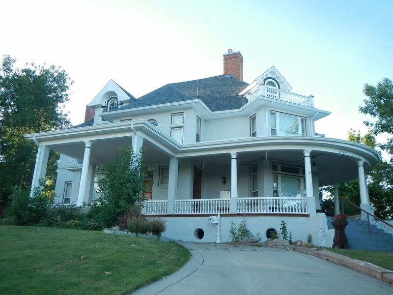
On 4th Avenue North, on the left when traveling west.
The front canted bay window hints at the modest one-story Queen Anne style residence that lies at the core of this elegant home. In 1891, the house was one of only two on the block. A small back addition had been added by 1900, when Mandeville . . . — — Map (db m143822) HM
On 5th Avenue South near 9th Street South, on the right when traveling east.
At the center of the African American community in Great Falls for more than a century, the Union Bethel AME Church began holding regular services in the first fire station in 1890. The following year African American residents gathered with white . . . — — Map (db m143792) HM
On Central Avenue near 23rd Street North, on the right when traveling east.
The Sisters of the Order of St. Ursula came to Montana in 1884 to establish schools for Indians. When the homestead movement created a need for more urban educational facilities, the Great Falls Townsite Company offered the sisters any two city . . . — — Map (db m143791) HM
On 4th Avenue North near 9th Street North, on the right when traveling west.
A grand home on a large corner lot, this Colonial Revival residence bespeaks the prominence of its first owners. Banker, rancher, and state senator William Floweree and his wife, Norma, built this brick two-and-one-half-story home in 1916. Its . . . — — Map (db m143806) HM
On 3rd Street Northwest near 3rd Avenue Northwest, on the right when traveling west.
William and Isabel Shea built this cozy one-story brick home in 1929. With its distinctive low profile, clipped-gable shingle roof, stucco siding, exposed rafter tails, and multi-pane windows, the inviting residence is a classic Craftsman style . . . — — Map (db m143670) HM
On Front Street near 13th Street, on the left when traveling north.
The bank was established June 1, 1880, by T. E. Collins, Charles Duer and L. H. Hershfield and Brother. It was first located in the Benton Record Building, then moved to this location in October 1881. The bank remained here until the large two-story . . . — — Map (db m142100) HM
On Front Street near 17th Street, on the left when traveling north.
I.G. Baker and T. C. Power built the original Thwing House in 1868. Under the watchful eye of Mrs. Thwing, this “downtown” hotel competed with the Overland. The hotel closed in 1870 and was rented as military officers’ quarters. It . . . — — Map (db m142134) HM
On Franklin Street near 13th Street, on the left when traveling east.
Minneapolis architects Kees and Fisk drew the plans for this magnificent Queen Anne style courthouse which opened in 1884. As the seat of one of Montana's nine original counties, its grand appearance represents the early affluence of this "Chicago . . . — — Map (db m142451) HM
On Chouteau Street near 16th Street, on the left when traveling east.
When fire destroyed the original Church of the Immaculate Conception in 1905, this beautiful Tudor style structure of rough cut stone and ornamental half-timbered gables replaced it in 1907. Salvaged from the blaze was a bell christened in 1880 for . . . — — Map (db m142454) HM
On Front Street near 15th Street, on the left when traveling north.
Originally this site was occupied by a wooden frame building that housed Mose Solomon’s Medicine Lodge. This legendary saloon was open twenty-four hours a day from spring thaw to first snow. When the building burned, prominent lawyer, customs . . . — — Map (db m161662) HM
Fort Benton’s building boom of 1887-1884 saw the construction of many commercial buildings made of locally produced soft brick. This fine example was built in 1881 as a saddlery by Davidson and Moffitt of Helena. The River Press Company, publisher . . . — — Map (db m142064) HM
On Front Street at 15th Street, on the right when traveling east on Front Street.
When railroads replaced steamboats, Fort Benton's importance as a trade center declined. In response, Fort Benton businessmen formed the Benton Bridge Company to construct a bridge across the Missouri River to capture the trade of the rapidly . . . — — Map (db m142414) HM
On Front Street near 15th Street, on the right when traveling east.
The Fort Benton Engine House, built in 1883, and the Grand Union Hotel are two of only a few structures remaining to remind us of the rapid expansion here during the flourishing steamboat days. When Fort Benton incorporated in 1883, a volunteer fire . . . — — Map (db m142417) HM
On Front Street near 18th Street, on the left when traveling north.
Founded in 1846 as the fur trade transitioned fro furs to buffalo robes, Fort Benton was both a trading post and a center for distribution of Indian annuities. In the early 1860s, Montana's gold rush and the initiation of steamboat traffic made the . . . — — Map (db m142173) HM
On 14th Street at Front Street, on the left when traveling north on 14th Street.
This grandiose, three-story Italianate style hotel welcomed weary river travelers to the Gateway of the Northwest, offering guests a luxurious refuge before setting out for less civilized destinations. Its opening in 1882 came at the end of the . . . — — Map (db m142062) HM
On Front Street near 17th Street, on the left when traveling north.
This structure opened in 1882 during Fort Benton’s "glory days" as Montana’s largest hardware store. T. C. Power and Hans Wackerlin operated the business. Wackerlin, a tinsmith, had come to Fort Benton in 1867 aboard the steam boat Richmond, which . . . — — Map (db m142136) HM
On Front Street near 16th Street, on the left when traveling north.
From the 1850s to 1887, Fort Benton was the trade center for this region of the American and Canadian West. Like others who chose to stay when the fur trade declined, I.G. Baker (last American Fur Company factor at the fort) turned to new endeavors. . . . — — Map (db m142133) HM
On Front Street near 14th Street, on the left when traveling north.
Members of Masonic Lodge #25 built this brick structure in 1882, housing their temple on the second floor. Grocer W. H. Burgess rented first floor space. Economic decline in the late 1880s caused the Masons to lose title, and Burgess, too, went . . . — — Map (db m142103) HM
On Front Street near 15th Street, on the left when traveling north.
Originally built to house the Stockmen’s National Bank, this solid structure represents typical pre-1900s commercial architecture. Its 1890 construction is significant as one of the few buildings erected after Fort Benton’s heyday and before . . . — — Map (db m142102) HM
On Front Street near 15th Street, on the left when traveling north.
In 1864, Mills and Douglas operated a restaurant and hotel on this corner. Mills and Robert S. Culbertson went into partnership in 1877, opening a new establishment called the Centennial Hotel in celebration of the United States' 100th birthday. . . . — — Map (db m142104) HM
On 14th Street at Choteau Street, on the right when traveling north on 14th Street.
St. Paul’s Episcopal Church, Fort Benton’s oldest church, is the oldest Episcopal Church in Montana. In continuous service since August 11, 1881, it appears today almost as it did upon opening. Architecturally, this Gothic style building is a fine . . . — — Map (db m142329) HM
On Front Street at 14th Street, on the left when traveling north on Front Street.
Originally built to house the Stockmen’s National Bank, this solid structure represents typical pre-1900s commercial architecture. Its 1890 construction is significant as one of the few buildings erected after Fort Benton’s heyday and before . . . — — Map (db m142101) HM
On Front Street near 17th Street, on the left when traveling north.
In 1867, merchant T. C. Power, destined to become one of the state’s wealthiest and most influential men, brought his first wagonload of goods to Fort Benton, where he set up shop in a borrowed tent. Still in business in 1916, Power constructed a . . . — — Map (db m142137) HM
On Front Street near 17th Street, on the left when traveling north.
T. C. Power and Bro. was founded in 1868 at approximately this location. Initially housed in a wooden building, the store was moved in 1879 to a large brick structure across the street. When the firm expanded, a hardware store was built next door . . . — — Map (db m142135) HM
On Virgelle Ferry Road North, on the left when traveling north.
Homesteaders, travelers, and railroad crews helped the tiny town of Virgelle thrive during the 1910s. Town founder Virgil Blankenbaker chartered the Virgelle State Bank in 1917 where he, his brother-in-law John G. Chancellor, C. J. McNamara, and . . . — — Map (db m161664) HM
On Virgelle Ferry Road North, on the left when traveling north.
Virgil F. Blankenbaker was among the first to homestead this areas when former Indian Reservation lands along the Missouri River opened to settlement in 1889. He accumulated miles of land across the plains and along the riverfront. Blankenbaker's . . . — — Map (db m161665) HM
On Jail House Lane near North 1, on the right when traveling south.
Ismay’s bustling business, wicked ways, and itinerant population of cowboys and railroad men earned it the nickname “Little Chicago.” This town, born with the construction of the Milwaukee Road across Montana, began in 1908 with the name . . . — — Map (db m164230) HM
On Palmer Street at North 10th Street, on the left when traveling east on Palmer Street.
E. H. Johnson, state legislator and Miles City’s first mayor, built this impressive modified Queen Anne style home in 1887. Attributed to Miles City architect Byron Vreeland, the irregular plan originally featured an elaborate arched porch and an . . . — — Map (db m164045) HM
On Main Street (State Highway 59) near South Jordan Avenue, on the right when traveling east.
High maintenance steam engines required railroads to locate large repair shops every two hundred miles. After the Chicago, Milwaukee, St. Paul and Pacific Railroad chose Miles City for a division point in 1907, the town grew rapidly. Population . . . — — Map (db m164145) HM
On Palmer Street at North 11th Street, on the left when traveling east on Palmer Street.
Nannie Alderson came to Montana from Kansas with her husband Walt in 1883. They operated a cattle ranch for a decade but moved to Miles City in 1893 so their children could attend school. In 1895, Walt died from head injuries after he was kicked by . . . — — Map (db m164048) HM
On Pleasant Street at North 10th Street, on the right when traveling east on Pleasant Street.
This gracious, historic residential neighborhood illustrates Miles City's prosperity as it evolved from a frontier town into the livestock, transportation, commercial, and governmental hub of eastern Montana. Businessmen and community leaders built . . . — — Map (db m164093) HM
On South 8th Street at Bridge Street, on the right when traveling south on South 8th Street.
The transformation of Miles City in the early 1900s into the economic, social, and governmental center of the valley precipitated the decision to build a permanent city hall. Ed Arnold, tailor and businessman, became one of the motivating forces . . . — — Map (db m164043) HM
On M (State Highway 59) near South Strevell Avenue, on the right when traveling east.
The steamer Far West carried Irish immigrant James Coleman to Fort Keogh in 1876. After working for the army sutler, Coleman moved into Miles City, where he managed a saloon frequented by army regulars. In 1882, he married his Irish bride, Margaret . . . — — Map (db m164146) HM
On Main Street near North 5th Street, on the left when traveling east.
The I. Orschel and Brothers clothing firm first located on this site in 1878 in a small wood-frame building. Following a disastrous fire that leveled much of the block, local businessmen formed a syndicate to build this four-part commercial building . . . — — Map (db m163978) HM
On Main Street near North Cottage Avenue, on the right when traveling east.
Hardware store owner, banker, and real estate developer George Miles, nephew of Colonel Nelson A. Miles, hired a contractor to build this hipped-roof cottage around 1910. Following completion of the Chicago, Milwaukee, St. Paul and Pacific Railroad . . . — — Map (db m164215) HM
On Main Street (State Highway 59) at North Merriam Avenue, on the left when traveling east on Main Street.
A sophisticated blend of Classical elements characterizes this intimately elegant residence that, despite its modest size, easily rivals the district’s grander “high style” homes. Built in 1907, the residence was then “out in the country,” its . . . — — Map (db m164168) HM
On Main Street (Business Interstate 94) near South 5th Street, on the right when traveling east.
Dr. Robert G. Redd served as an army surgeon at Fort Keogh in the 1870s. Redd resigned in 1881 to assume a private practice. He served as county physician, coroner, and surgeon for the Northern Pacific Railroad as well as mayor from 1889 to 1900. He . . . — — Map (db m163878) HM
On Main Street (State Highway 59) near North Winchester Avenue, on the left when traveling east.
Wealthy Miles City residents looked to the undeveloped area east of the Northern Pacific tracks to build their homes in the early twentieth century. Among them were Ed and Doris Love who had this Prairie Style home constructed in 1916. Its bands of . . . — — Map (db m164149) HM
On North 11th Street at Palmer Street, on the right when traveling north on North 11th Street.
An eclectic blend of Romanesque, Gothic, and Queen Anne architectural styles, this 1886 church survives as designer Byron Vreeland’s most significant building in Montana. Vreeland blended these styles as his architectural signature in many of his . . . — — Map (db m164049) HM
On Main Street (Business Interstate 94) at North Montana Avenue, on the left when traveling east on Main Street.
Charter members George and Helen Miles bestowed this land on the church in 1882. Since that time the First Presbyterian Church has occupied this space. Church trustees met in 1911 to discuss the construction of a larger $30,000-$40,000 church. . . . — — Map (db m164116) HM
Following the defeat of General Custer and the Seventh Cavalry at Little High Horn on June 25, 1876, Congress appropriated $200,000 to establish two forts in Montana Territory. The U.S. Army selected one site along the Tongue River, a mile and a . . . — — Map (db m164231) HM
On Main Street (Highway 59) near South Custer Avenue, on the right when traveling east.
This American foursquare style home appears to have been designed by prominent architect Brynjulf Rivenes. Built between 1910 and 1914 for businessman George Foster, its compact simplicity is an elegant, individual statement of the prosperity Miles . . . — — Map (db m164119) HM
Born in Wisconsin, Al Furstnow settled permanently in Miles City in 1894 and became the major saddler in the northwest. In 1895, Furstnow commissioned Byron Vreeland to build this Queen Anne style home, unusual because the architect usually designed . . . — — Map (db m164091) HM
On Main Street (State Highway 59) at South Lake Avenue, on the right when traveling east on Main Street.
Cabinet and furniture makers also made caskets, and so the two businesses often went hand in hand. Furniture dealer James E. Graves purchased H. C. Plimpton’s long-established furniture and undertaking business in the 1920s. In 1929, Graves moved . . . — — Map (db m164118) HM
On Main Street (State Highway 59) near South Jordan Avenue, on the right when traveling east.
The stylistic versatility of architect Brynjulf Rivenes is well demonstrated in this distinguished home built for Miles City businessman Harry J. Horton. The simple foursquare plan combines wide eaves, a low hipped roof, and massive brick pillars, . . . — — Map (db m164121) HM
On North Jordan Avenue near Clark Street, on the right when traveling north.
A converted two-story house served as the county hospital in 1907, a year before the Chicago, Milwaukee, St. Paul and Pacific Railroad arrived in Miles City. With encouragement from the railroad, which needed a place to treat injured workers, the . . . — — Map (db m164171) HM
The New Deal’s National Recovery Administration provided funds for the construction of several significant buildings at the fort in the 1930s. These included a dairy barn, milk house, cattle sheds, and this large horse barn. Designed and built in . . . — — Map (db m164265) HM
On Main Street (Business Interstate 94) near South 8th Street, on the right when traveling east.
The Jackson Block’s spare façade bears witness to those watchwords of modern architecture, “form follows function.” The two-story building suggests ways that urban architectural trends were translated and adapted in small communities. Its main . . . — — Map (db m164044) HM
On Pleasant Street at North 9th Street, on the left when traveling east on Pleasant Street.
Complex rooflines and decorative details define this wood-frame residence. Particularly noteworthy are the ornamental bargeboards fastened to the roofline and the unique bull’s-eye pattern decorating the front gable. Other details include windows . . . — — Map (db m164095) HM
On North Cottage Grove Avenue near Main Street, on the left when traveling north.
Sometimes called “labor’s aristocracy,” locomotive engineers were the highest paid workers on the railroad. That fact gave William Kelly, an engineer for the Milwaukee Road, the means to purchase this one-story home. In 1920 he lived here with his . . . — — Map (db m164172) HM
On Main Street (Business Highway 94) near South 6th Street, on the right when traveling east.
This popular gathering place, one of Miles City’s oldest established businesses, has been proclaimed by connoisseurs the perfect bar. Originally a saloon (1893), then a fine saddlery (1900-1907), businessman James Kenney purchased the property in . . . — — Map (db m163980) HM
On North 11th Street near Palmer Street, on the right when traveling north.
The end of the 1880s witnessed development of Miles City’s north side, with expensive homes being built on generous tracts of land. As land became scarce, parcels were carved from spacious lawns and working families became the neighbors of prominent . . . — — Map (db m164090) HM
On Main Street (State Highway 59) at South Stacy Avenue, on the right when traveling east on Main Street.
Built for C. N. and Louise E. Lukes in 1911, the home is also known as the Ed Love House. Lukes was cashier of the Commercial State Bank and after the deaths of C. N. and Louise in 1929, ownership passed to their daughter, Doris Lukes Love, and her . . . — — Map (db m164148) HM
On Palmer Street near North 11th Street, on the left when traveling east.
Nestled amidst grand Queen Anne style houses is this early folk residence. The wooden home, constructed for Scottish immigrant John McAusland, appears on an 1883 bird’s-eye map of Miles City. A steeply pitched side-gable roof and a small dormer . . . — — Map (db m164046) HM
On North 11th Street at Pleasant Street, on the right when traveling north on North 11th Street.
In 1910, the Methodists hired a New York fundraising firm to raise funds for a new, larger church to replace the 1883 building. The growing congregation raised $14,000 and neighbor C. J. Wagenbreth donated the needed capital to complete the project, . . . — — Map (db m164092) HM
On Main Street (State Highway 59) near South Jordan Avenue, on the right when traveling east.
The development of this elegant residential neighborhood reflects Miles City's second growth spurt in the early twentieth century. Although the population of this "cowtown" waned between 1890 and 1905, the advent of the Chicago, Milwaukee and St. . . . — — Map (db m164120) HM
On Main Street (Business Interstate 94) near South 6th Street, on the right when traveling east.
The Main Street historic district reveals Miles City’s major growth periods of 1882-1887, 1905-1920, and 1935- 1940. The first of these began with the arrival of the Northern Pacific in 1881, when imposing brick business blocks began to replace the . . . — — Map (db m163979) HM
On Main Street (State Highway 59) near South Custer Avenue, on the right when traveling east.
A low-pitched hipped roof, an asymmetrical open front porch with massive square porch supports, clean lines, and wide overhanging eaves mark the two-story Pope residence as a classic example of the Prairie style. Builder Thomas Burton clad the . . . — — Map (db m164117) HM
Breaking and training thousands of horses at Fort Keogh for the U.S. military and Allied French and British forces was crucial during World War I because of the military’s reliance on horse-drawn transportation. This two-story mess hall served . . . — — Map (db m164233) HM
On Main Street (State Highway 59) at North Jordan Avenue, on the left when traveling east on Main Street.
Nature, comfort, simplicity, honesty, and integrity were ideals incorporated into early-twentieth-century architecture. This Craftsman style bungalow is an exceptional expression of those ideals. Its compact floorplan and modestly adorned exterior . . . — — Map (db m164169) HM
On Main Street (State Highway 59) at South Strevell Avenue, on the right when traveling east on Main Street.
Determined to bring the Chicago, Milwaukee, and St. Paul Railroad to Miles City, land developer, cattleman, and banker Lorenzo Stacy organized his fellow businessmen to secure and donate property for the railroad’s right-of- way. In 1908, the . . . — — Map (db m164147) HM
On Main Street at North 5th Street, on the left when traveling east on Main Street.
Since the 1880s, Miles City has been the trade, service, and social center for Eastern Montana ranchers. After its famed McQueen House burned down, town booster Joseph Leighton built the Leighton, 1898-1899, which became an area landmark. Within a . . . — — Map (db m163974) HM
On South Strevell Avenue at Stower Street, on the right when traveling north on South Strevell Avenue.
Armed with a degree from the Ontario Business College, Canadian-born Thomas Shore arrived in Miles City in 1896. He and former cowboy Wirt Newcom formed a partnership and opened a department store on Main Street in 1900. The store flourished, . . . — — Map (db m164174) HM
On Pleasant Street at North 10th Street, on the left when traveling east on Pleasant Street.
The elegance of this magnificent Neoclassical style mansion belies the humble roots of its first owner, George H. Ulmer, the Pennsylvania-born son of a German immigrant. Ulmer came to Miles City in 1883, and by 1889 partners George Miles and Charles . . . — — Map (db m164094) HM
On South Lake Street (Avenue) at Dickinson Street, on the right when traveling north on South Lake Street (Avenue).
Log cabins and canvas tents lined Miles City’s Main Street when Walrond Snell and William Ladd opened their crockery business in the late 1870s. Snell sold his interests in 1883, returning to his native England to marry his sweetheart, Elizabeth . . . — — Map (db m164173) HM
Hundreds of military and civilian residents at Fort Keogh made the fort’s water supply a primary concern. By 1879, two thousand feet of pipe had been laid and seven cisterns installed. A converted boiler pumped water from the Yellowstone River for . . . — — Map (db m164264) HM
On Main Street (State Highway 13) just south of 2nd Avenue, on the right when traveling south.
The settlement of Old Scobey relocated here from the Poplar River flats to greet the approaching Great Northern Railway branch line in 1913. By the time the first train arrived on Thanksgiving Day, the two-story Commercial Hotel—today the south . . . — — Map (db m202833) HM
On West Bell Street near North Merrill Avenue, on the left when traveling south.
Contractor John Holm constructed this small two-story building for the Dion family in 1929 after he had remodeled the Dion Block on one side and built the J.C. Penney Building on the other. This final addition to the five-building Dion Block shares . . . — — Map (db m163465) HM
he Northern Pacific Railroad platted the townsite of Glendive in 1882 against the arid Montana “badlands.” The location was an ideal supply and distribution center since it was where the railroad first met the Yellowstone River, but . . . — — Map (db m163580) HM
On North Douglas Street at West Bell Street when traveling north on North Douglas Street.
Rancher and banker Charles Krug came west from Ohio in 1878, searching for opportunity and a climate to relieve his sister Emma’s asthma. In 1881, he and Emma settled in Glendive where she was a seamstress and he worked for the railroad. Krug built . . . — — Map (db m163564) HM
On South Merrill Avenue near West Bell Street, on the right when traveling south.
Henry Dion built this brick building circa 1894 to expand his mercantile business. In 1908, he sold it to his two eldest sons, Harry N. and Fred. The brothers enlarged the original one-story building in 1910, adding a second story with apartments . . . — — Map (db m163802) HM
On South Merrill Avenue at West Bell Street when traveling south on South Merrill Avenue.
Fire swept through Glendive’s wood-frame businesses in January of 1886, destroying Henry Dion’s saloon and general merchandise, established on this corner in 1881. Dion constructed a kiln and built a more substantial fire- resistant brick building, . . . — — Map (db m163464) HM
On West Towne Street at North Kendrick Avenue, on the right when traveling west on West Towne Street.
Noted Miles City architect Brynjulf Rivenes designed this splendid English Gothic style church in 1909. Constructed under Pastor T. S. Leland during intense community growth brought about by homestead settlement, the building replaced the smaller . . . — — Map (db m163801) HM
On South Merrill Avenue near West Bell Street, on the right when traveling south.
Fancy arches and other fine detailing highlight the façade of this commercial building, constructed as an investment in 1905 by pioneer Henry Dion. The outer walls are of softer, locally produced “Glendive brick” while quality imported . . . — — Map (db m163803) HM
On West Bell Street near North Merrill Avenue, on the left when traveling west.
After the death of Glendive pioneer Henry Dion in 1920, his widow and children contracted with John Holm to construct this commercial building according to the specifications of the J.C. Penney Company. Built in 1929, the architecture is typical of . . . — — Map (db m163560) HM
On North Meade Avenue near West Benham Street, on the left when traveling north.
he Catholics of Glendive first organized at St. Juliana’s, a 100-seat church purchased from the Congregationalists in 1886. After nearly forty years, they had outgrown those quarters. In 1924, architect Brynjulf Rivenes of Miles City designed a new . . . — — Map (db m163584) HM
On East Park Avenue (State Highway 1) near Cherry Street, on the left when traveling east.
Backed by the powerful San Francisco syndicate of Hearst, Haggin and Tevis, Marcus Daly built the world’s largest smelter (combined upper and lower works) on Warm Springs Creek between 1883 and 1889. Along with the smelters, Daly envisioned a . . . — — Map (db m183523) HM
On East Park Avenue (State Highway 1) near Oak Street, on the right when traveling east.
Though altered over many years to look like three separate buildings, this early 1900s brick commercial block is actually one large building (extending to the corner of Oak). Originally divided by interior partition walls, the building hosted three . . . — — Map (db m183393) HM
On West Third Street near Locust Street, on the left when traveling west.
Anaconda’s business leaders located on the town’s west side beginning in the 1890s. The idyllic neighborhood was far from the smelter and close to commerce on Main and Park streets. Tree-lined sidewalks with street lamps, a large public park, and a . . . — — Map (db m205590) HM
On East 3rd Street at Cedar Street, on the left when traveling west on East 3rd Street.
A fleet of twelve hundred masons and carpenters flocked to Warm Springs Creek in 1883 to build Marcus Daly’s Anaconda Company smelter. Daly hired Welsh masonry contractor John “Jack” W. Cornelius to oversee the construction process for his enormous . . . — — Map (db m205726) HM
On East Park Avenue (State Highway 1) near Cedar Street, on the right when traveling east.
Anaconda Copper Mining Company carpenter Daniel R. Beck built this small brick building in 1896. He lived in one half and rented out the other half. Beck was an early resident of Anaconda, arriving in 1883 when it was still a hodgepodge of shacks . . . — — Map (db m183458) HM
On Main Street at West 5th Street, on the left when traveling north on Main Street.
Intricate ornamental cresting caps the dome on the octagonal tower of this handsome residence. Its eclectic architecture combines elements of the Queen Anne and French Second Empire styles. A partial Mansard roof at the northeast corner and a front . . . — — Map (db m205803) HM
On Chestnut Street near East 5th Street, on the right when traveling north.
Rapidly increasing demand for copper ore in the 1890s brought an influx of more than 5,000 new residents to the Smelter City between 1890 and 1900. To house them all, a fleet of carpenters built hundreds of cottages and multi-family units. This . . . — — Map (db m205713) HM
On East Third Street at Ash Street, on the left when traveling west on East Third Street.
Rapidly increasing demand for copper ore in the 1890s brought an influx of more than 5,000 new residents to the Smelter City between 1890 and 1900. To house them all, a fleet of carpenters built hundreds of cottages and multi-family units. This . . . — — Map (db m205708) HM
On 401 East Commercial Avenue at Cedar Street, on the left when traveling west on 401 East Commercial Avenue.
Copper magnate Marcus Daly had great expectations for Anaconda when the town was platted in 1883, hoping one day the town would become Montana’s capital. It was with that goal in mind that plans for a magnificent city hall were conceived. Architects . . . — — Map (db m205641) HM
On East Park Avenue (State Highway 1) near Chestnut Street, on the right when traveling east.
Austrian immigrant George Barich came to Anaconda from Butte in 1883 to work at the smelter. He later turned to commercial business and, in 1892, commissioned builders Daniel Dwyer and John Cosgrove to construct the first floor of this block. Barich . . . — — Map (db m183452) HM
On West Commercial Avenue near Locust Street, on the right when traveling west.
Tired of exorbitant freight rates, copper king Marcus Daly decided to build his own railroad in 1892 to haul ore from the Butte mines to his Anaconda smelter. Daly envisioned the Butte, Anaconda and Pacific Railway extending to the Pacific Ocean. . . . — — Map (db m205592) HM
On Main Street at West 8th Street when traveling south on Main Street.
It took millions of miles of copper to build the telegraph, telephone, and electrical lines that transformed the United States from a collection of small, isolated communities to a cohesive, industrialized nation. Looming gallows frames and the . . . — — Map (db m128116) HM
On East Commercial Avenue at Cherry Street on East Commercial Avenue.
This building began as a one-story, wood-frame grocery store on Main Street in 1883. In 1885, owner David Cohen Sr. sided it with brick veneer, giving it a more permanent appearance. Soon after, a fire broke out, destroying nearly everything on the . . . — — Map (db m205706) HM
On Main Street at West 8th Street when traveling south on Main Street.
The valley known by Native Americans as “Lodge of the White Tailed Deer” officially became Deer Lodge County when this area was part of the Territory of Idaho. After the creation of the Territory of Montana in 1864, the first territorial . . . — — Map (db m128113) HM
On Main Street at West Commercial Avenue, on the right when traveling north on Main Street.
A heavy metal cornice, cast iron columns, and a metal frieze still embellish this building, constructed in 1895. Two cast-iron oriel windows once also graced the upper story. The Anaconda Company’s foundry produced the decorative metal front, a . . . — — Map (db m180973) HM
On Locust Street at West 6th Street, on the left on Locust Street.
Anaconda’s elite began to build homes on the West Side in the 1890s, and this Queen Anne style mansion was one of the first to grace upper Locust Street. Built in 1894 for Fred Clark, librarian at the Hearst Free Public Library, the elegant . . . — — Map (db m205884) HM
On East Park Avenue (State Highway 1) near Main Street, on the right when traveling east.
French immigrant and wealthy Deer Lodge Valley dairyman John Furst built this brick store and boardinghouse for $5,000 in 1895. Just steps away from Marcus Daly’s new bank and the fine Montana Hotel, the Furst Block fit in well amongst its . . . — — Map (db m183392) HM
On West 3rd Street near Poplar Street, on the left when traveling west.
New residents flooded the housing market as Anaconda’s smelter works expanded into the twentieth century and the town began to outgrow its original perimeters. The City Council approved several new additions including this area, annexed as the First . . . — — Map (db m205588) HM
On Main Street at East 4th Street, on the left when traveling south on Main Street.
Phoebe Hearst, wife of wealthy California senator George Hearst, had a special relationship with Anaconda. Hearst was one of Daly’s principal investors and Mrs. Hearst took an active interest in improving Anaconda’s cultural opportunities. She asked . . . — — Map (db m180978) HM
On Main Street at East Commercial Avenue, on the right when traveling east on Main Street.
Anaconda grew practically overnight. Platted in June 1883, Anaconda already boasted eighty buildings by December 1884, including a wood-frame clothing store on this corner, built by pioneering Jewish merchant Wolfe (William) Copinus. In 1888, . . . — — Map (db m205650) HM
On East Park Avenue (State Highway 1) near Chestnut Street, on the left when traveling east.
The Imperial Meat Market specialized in fresh meat, sausage, game, fish, and oysters when D. D. Walker and Israel Gibbs opened it in a wood-frame building on this lot in 1889. Shop foreman Albert Bourbonniere, in partnership with Big Hole Valley . . . — — Map (db m183451) HM
On Main Street near West 5th Street, on the left when traveling north.
Alice and George Winston were among the first residents of the Main Street neighborhood south of Anaconda’s business district. The Anaconda Weekly Review noted in August of 1888 that the Winstons’ fine home was well under construction. A lovely . . . — — Map (db m205801) HM
1002 entries matched your criteria. Entries 101 through 200 are listed above. ⊲ Previous 100 — Next 100 ⊳