On Kennedy Street at Broadway (Trans-Canada Highway) (Provincial Highway 1), on the right when traveling south on Kennedy Street.
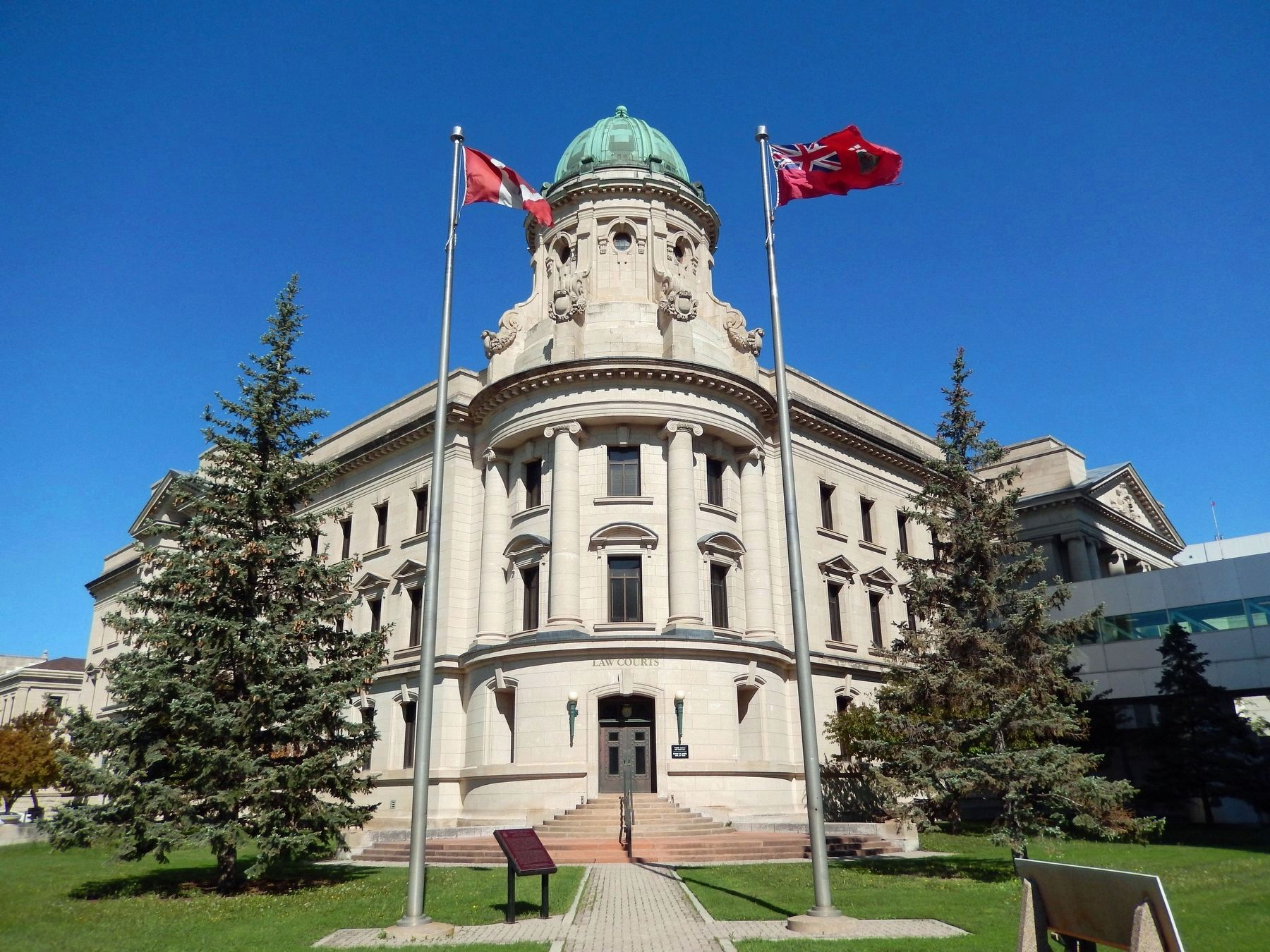
[English] The construction of this monumental court house between 1912 and 1916 marked the peak of a period of dramatic growth for Winnipeg. Its classically-inspired design complemented the nearby Legislative Building and provided . . . — — Map (db m220569) HM
Near Tache Avenue just north of Provencher Boulevard, on the left when traveling north.
[Français] Avocat et journaliste, Royal arrivait au Manitoba en 1870. L’année suivante, il fondait « Le Métis, » journal qui resta voué à la cause des Canadiens–Français et des Métis du Manitoba et du Nord-Ouest, jusqu'en 1881. . . . — — Map (db m219658) HM
On Provencher Boulevard (Manitoba Route 57) at Rue Aulneau, on the right when traveling west on Provencher Boulevard.
[English] In 1817 Jean-Baptiste Lagimodiere and his wife Marie-Anne Gaboury settled on Seine River lots granted them by Lord Selkirk. They arrived in 1806, the first white couple to settle in the northwest. They became the . . . — — Map (db m218999) HM
On Ellice Avenue just east of 335 Donald Street, on the left when traveling west.
On this site in 1895 was built the first Masonic Temple in use until 1969 This tablet erected by Grand Lodge of Manitoba A.F. & A.M. in their centennial year 1975 — — Map (db m215293) HM
Near Colony Street (Provincial Highway 62) just south of Webb Place, on the right when traveling north.
The oldest surviving public school building in Winnipeg, Isbister School was built during the fall and winter of 1898–99 to plans by Samuel Hooper, Provincial Architect of Manitoba from 1904 to 1911. Named for Alexander Kennedy Isbister . . . — — Map (db m220675) HM
On Main Street (Manitoba Route 52) at Pioneer Avenue, on the right when traveling north on Main Street.
[English] Commissioned by Public Works and Government Services Canada, No. 1 Northern is sculptor John Nugent’s tribute to the accomplishments of Western Canadian grain producers. Until the early 1970’s, No. 1 . . . — — Map (db m215595) HM
On Donald Street just south of Portage Avenue (Provincial Route 85), on the right when traveling south.
The first Winnipeg meeting of the Directors of the T. Eaton Co. Limited was held 30 feet west of this on July 12th 1905, presided over by Mr. Timothy Eaton, President. — — Map (db m215598) HM
On Donald Street just north of Graham Avenue, on the left when traveling south.
[English] Erected in 1883-1884 to the designs of Winnipeg architect Charles H. Wheeler, this picturesque limestone structure is a fine example of the High Victorian Gothic style. It displays a creative interpretation . . . — — Map (db m214576) HM
On Main Street (Manitoba Route 52) just south of William Stephenson Way (Manitoba Route 57), on the right when traveling north.
Near this spot stood the original office of The Nor’Wester, the first newspaper on the Canadian prairies, founded in the Red River Settlement by William Buckingham and William Coldwell. The first issue appeared on December 28, 1859 and publication . . . — — Map (db m215506) HM
On Graham Avenue just east of Donald Street, on the right when traveling east.
Among the most basic questions asked by man is "Why?" To find the answers, he has become inventor, explorer and philosopher. As the answers to his question came, the need arose for a place where records could be kept of what he had learned, done . . . — — Map (db m215597) HM
On Graham Avenue just east of Donald Street, on the right when traveling east.
The Winnipeg Public Library began in 1888 when the City Council provided free accommodation and an annual grant to assist the library of the Manitoba Historical and Scientific Society. The library included books from the Red River settlers and 500 . . . — — Map (db m215596) HM
This bridge was designed not only for heavy freight cars to travel over the Assiniboine River but also for steamships to travel under it. The center span of the bridge lifts and is known as a bascule bridge (from the French word for "see-saw"). . . . — — Map (db m106490) HM
Strategically located at the junction of two major rivers which form part of a vast continental network, this spot has witnessed many of the key events of Western Canadian history. This was a traditional native stopping place and for this reason La . . . — — Map (db m106447) HM
Near Forks Market Road, 0.3 kilometers east of Fort Gibraltar Trail.
[English] Between 1731 and 1743 La Vérendrye, a native of Trois-Rivières, supervised the construction of a series of fur trade posts west of Lake Superior. To secure the trade of the resident Cree, Ojibwa and Assiniboine, he and his . . . — — Map (db m220485) HM
Angered that they had not been consulted about the transfer of the Hudson's Bay Company territories to Canada, the inhabitants of the Red River Settlement, led by Louis Riel, in 1869 proclaimed a Provisional Government which took control of the . . . — — Map (db m106489) HM
"The Path of Time" celebrates the procession of history at The Forks that continues to the present. The tools used to shape the Prairies - stone axes, scythes, locomotives, steam tractors, computers - are reflected, each in turn, on the . . . — — Map (db m106418) HM
Near Chancellors Circle, 0.2 kilometers north of Dafoe Road West.
Reginald Buller was born in Birmingham, England, where he attended Queen’s College and prepared for the B.Sc. (Ext) of the University of London (1896). From 1898-1901, as an 1851 Exhibition Scholar, he pursued research in Leipzig (Ph.D.-1899), . . . — — Map (db m219698) HM
On University Crescent at Dysart Road, on the right when traveling south on University Crescent.
This statue commemorates and honours Cal Murphy, a man who contributed so much to Winnipeg and the Blue Bombers in his 14 years with the club. He was a leader in every sense: in his dealings with people, in his fierce determination, and in his . . . — — Map (db m219700) HM
Near Chancellors Circle, 0.2 kilometers north of Dafoe Road West.
A Literary Lion Carol Shields was a Professor of English at the University of Manitoba from 1982 until 2000. Born in Oak Park, Illinois, she moved to Canada in 1957. Her novels, plays, and poetry won major awards globally including the Governor . . . — — Map (db m219699) HM
Near Chancellors Circle, 0.2 kilometers north of Dafoe Road West.
The Father of Canola Born in Vestfold, Manitoba, Dr. Stefansson received his Ph.D. in Plant Science from the University of Manitoba in 1966. He is internationally known for his vision and innovative research methods that transformed rapeseed . . . — — Map (db m219692) HM
Near Chancellors Circle, 0.2 kilometers north of Dafoe Road West.
A Pediatric Pioneer Born in Winnipeg, Manitoba, the son of a prominent Manitoba surgeon, Dr. Chown received his medical degree from the University of Manitoba in 1922 and made one of Manitoba's greatest medical discoveries. His world-leading . . . — — Map (db m219690) HM
Near Chancellors Circle, 0.2 kilometers north of Dafoe Road West.
An Innovator in Maternal and Child Health Born in Winnipeg, Manitoba, Dr. Bowman graduated from the University of Manitoba Medical College in 1949. He pioneered the use of intrauterine transfusions in North America, reducing infant deaths from . . . — — Map (db m219685) HM
122 entries matched your criteria. Entries 101 through 122 are listed above. ⊲ Previous 100