On Monument Road near Hermosa Road, on the right when traveling south.
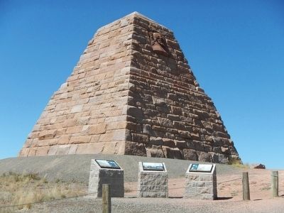
Commissioned by the Union Pacific Railroad, the Ames Monument is a memorial to the Ames brothers, Oakes and Oliver, for their contributions to the building of the Transcontinental Railroad. Their strong support, drive and influence were . . . — — Map (db m89647) HM
Near Interstate 80 at milepost 332, on the left when traveling east.
This area of southeast Wyoming is rich in history, geology and recreational activities. Within a short distance from this point, sites abound of early day events that have shaped the western heritage of this area, including the Arapaho and . . . — — Map (db m68052) HM
On Monument Road near Hermosa Road, on the right when traveling south.
Construction of the Transcontinental Railroad across the United States was one of the most significant historic events of the 1800s. Built almost exclusively with manual labor and hand tools, the cross-country railroad took only four years to . . . — — Map (db m89646) HM
This small pine tree that seems to be growing out of solid rock has fascinated travelers since the first train rolled past on the Union Pacific Railroad. It is said that the builders of the original railroad diverted the tracks slightly to pass by . . . — — Map (db m62159) HM
In remote areas of Albany County, Wyoming, passenger trains carrying mail, payroll monies, and express deliveries were tempting targets for bandits. On June 2, 1899, the Union Pacific Overland Flyer No. 1 was flagged down near Wilcox Station, east . . . — — Map (db m89659) HM
Near Interstate 80 at Elk Mountain Arlington Road.
The area near the Wagonhound Rest Area has played an important role in western transportation since the earliest days of human activity in the Rock Mountain west. The area has provided Wyoming's earliest inhabitants, explorers, westbound settlers, . . . — — Map (db m47142) HM
Near W. Davis Street at Bennett Street, on the right when traveling south.
In the summer of 1867, a survey party led by General Grenville M. Dodge seeking a route for the Union Pacific Railroad stopped here.
General John A. Rawlins, a member of the party, spoke of the spring as "the most gracious and acceptable of . . . — — Map (db m67982) HM
On County Route 347 near Interstate 80, on the right when traveling north.
The old road bed & cut below are believed to be part of the rail road that was constructed in 1887 by the Union Pacific Railroad to connect Fort Steele to Denver, CO. It was to follow the North Platte to North Park, Colorado and down the Cache la . . . — — Map (db m89987) HM
On County Route 347 near Interstate 80, on the right when traveling north.
During construction of the Union Pacific Railroad land speculators and a large contingent of undesirables kept pace with or move ahead of the construction crews and their military escorts. Townsite speculators tried to anticipate depot locations, . . . — — Map (db m89755) HM
On County Route 347 near Interstate 80, on the right.
At age 18, Fenimore Chatterton arrived in Wyoming on September 12, 1878 to begin a lifelong career of service to Wyoming.
The young Fenimore came west on the Union Pacific to Fort Steele for a bookkeeping job at the J.W, Hugus Trading Post. . . . — — Map (db m89995) HM
Near Old Highway, 0.1 miles east of County Road 347, on the left when traveling east.
The south central portion of Wyoming has long been a travel corridor for prehistoric and historic people. Native American tribes from the Great Basin region to the west crossed this area to hunt buffalo on the eastern plains.
From 1810 . . . — — Map (db m67988) HM
On State Highway 374 near Interstate 80, on the right when traveling north.
The Union Pacific Railroad and the North Platte River are important parts of the story of Fort Fred Steele. Located where these two great resources met, the fort and the local industries surrounding it would depend upon the rails and water for . . . — — Map (db m89759) HM
On County Route 347 near Interstate 80, on the right when traveling west.
Passenger travel on the Union Pacific Railroad began in July of 1868, with the first trans-continental service beginning just 10 days after the golden spike was driven on May 10, 1869 at Promontory Point in Utah. The first passenger trains were . . . — — Map (db m89915) HM
On County Route 347 near 80, on the right when traveling west.
In 1868 the Union Pacific Railroad was rapidly moving west with the short lived railhead towns leading the way. In early July, General Dodge ordered the citizens of Brownsville to move three miles from the river to the edge of the Dry Desert. This . . . — — Map (db m89916) HM
On Brownfield Road (County Route 61) near West Center Street (Business Interstate 25), on the left when traveling south.
Car #1886 was built at St. Louis Car Company in 1884 as a part of an order for ten short sixty foot coaches for service on the so called "Cowboy Line" of the C&NW being built at the time through Douglas to Lander, Wyoming.
The car was rebuilt in . . . — — Map (db m92181) HM
On Brownfield Road (County Route 61) near West Center Street (Business Interstate 25), on the left when traveling south.
The oldest piece in the display, the car was built by the Burlington and Missouri River Railroad in the company shops at Plattsmouth, Nebraska in 1884 at a cost of $1023 as a mainline freight caboose. It was rebuilt and modernized with new brake . . . — — Map (db m92182) HM
On Brownfield Road (County Route 61) near West Center Street (Business Interstate 25), on the left when traveling south.
The Douglas Railroad Interpretive Center is located on the site of the historic Chicago and Northwestern Railroad Depot. The Interpretive Center was developed by the City of Douglas and dedicated in August 1995 as a legacy to the major industries . . . — — Map (db m92163) HM
On Brownfield Road (County Route 61) near West Center Street (Business Interstate 25), on the left when traveling south.
Built as Fairmont Model M-19 series AA, Group 4, serial #217980. Originally sold to the Union Pacific Railroad and later sold to and used by the Colorado & Southern as a track inspection car, probably by track foremen based in Casper.
Little . . . — — Map (db m92164) HM
On Brownfield Road (County Route 61) near West Center Street (Business Interstate 25), on the left when traveling south.
Car was built by Pullman Standard at Pullman, Ill in December of 1950 as a part of an order for eight sleeping cars with 16 duplex roomettes and four bedrooms. Car was assigned to the Western Star, their secondary Chicago to Seattle train. With a . . . — — Map (db m92178) HM
On Brownfield Road (County Route 61) near West Center Street (Business Interstate 25), on the left.
This car was built by Western American Car & Foundry Company in Seattle, WA in July 1914 for the Union Pacific Railroad subsidiary Oregon Short Line as a box car and was numbered as their #120579. Car was converted to a double deck stock car in . . . — — Map (db m92179) HM
On Brownfield Road (County Route 61) near West Center Street (Business Interstate 25), on the left when traveling south.
This car was built by the Pullman Car Company at their Michigan City, Indiana plant in February of 1911 for the Union Pacific subsidiary Oregon Short Line Railroad as their #331. The car was renumbered to #2114 in 1914 and again renumbered to #1897 . . . — — Map (db m92165) HM
Near East Lincolnway near Nation Way, on the left.
The 4004 is one of eight surviving examples of the world's largest steam locomotives. The Union Pacific Railroad had 25 of these goliath built, at a cost of over a quarter million dollars each. The 4004 ran primarily between Cheyenne and Ogden, . . . — — Map (db m95202) HM
Near Dey Avenue south of W. Jefferson Road, on the left when traveling south.
S.W. corner of site chosen by General Grenville Dodge in 1867 for the division point of the U.P.R.R. and for the location of Cheyenne City. The original 4 sq miles were laid at an angle to give "all houses maximum sunshine throughout the year." This . . . — — Map (db m68053) HM
Twenty-five Big Boys, the world's largest steam engines, were built exclusively for Union Pacific by the American Locomotive Company in Schenectady, New York between 1941 and 1944. Each locomotive was 132 feet long and weighed 1.2 million pounds. . . . — — Map (db m95200) HM
Near High Plains Road near Interstate 25, on the left when traveling east.
Cheyenne was founded in 1867 as a terminal for the Union Pacific's transcontinental railway through southern Wyoming. The city grew bigger and faster than most rail towns, in part due to nearby U.S. Army Fort D.A. Russell, established in 1867, and a . . . — — Map (db m92203) HM
On Capitol Avenue just south of Lincolnway, on the left when traveling south.
Side A Incorporated as the Cheyenne & Burlington Railroad in March 1887, the 30-mile long Wyoming segment was a part of the larger 145-mile long Chicago, Burlington & Quincy (CB&Q) Railroad line that ran from Midland, Nebraska, westward to . . . — — Map (db m47181) HM
On Capitol Avenue just south of Lincolnway, on the left when traveling south.
Side A By 1868 the community boasted 3,000 to 4,000 residents, plus business, schools, churches and newspapers. The UP's stone roundhouse was the first permanent structure (non-wood) built in town. The City's phenomenal growth produced its . . . — — Map (db m47182) HM
The Trolleys The railway included a connector past the Fairgrounds to Fort S.A. Russell. Although 1890 drawings show a fail line going up over the wooden viaduct to South Cheyenne, it was never completed and no trolley service went south of the . . . — — Map (db m47159) HM
On Capitol Ave just south of Lincolnway, on the left when traveling south.
Part 1
Side A
The story of the Union Pacific Railroad is also a story of Wyoming and particularly Cheyenne. One cannot be told without the telling of the other. It is no exaggeration to say that Cheyenne, Fort D.A. Russell (now F.E. . . . — — Map (db m47178) HM
The Union Pacific Depot was built in 1886 and given to the community or Cheyenne in April 1993 by the Union Pacific Railroad Company. — — Map (db m47157) HM
Near Lions Park Drive near Carey Avenue, on the right when traveling south.
Union Pacific Steam Engine #1242 is the oldest coal burning steam locomotive in Wyoming. Union Pacific Railroad (UP) donated "Old Sadie," as she was nicknamed, to the City of Cheyenne in 1955 after being retired from the Walcott-Saratoga-Encampment . . . — — Map (db m95216) HM
On Coates Avenue near Main Street (County Route 215A), on the right when traveling south.
On June 11, 1867, Lathrop Hills led a party of surveyors up the nearby Lodgepole Creek, staking out the location for the Union Pacific Railroad, the first transcontinental railroad. Hills was riding out in front of the group when he was attacked by . . . — — Map (db m95169) HM
On Parson Street at Interstate 80, in the median on Parson Street.
The region’s unique geology created ‘woodland islands’ for planes and animals, and played a key role in the routing of the Transcontinental Railroad
Pine Bluffs
The area’s distinctive Pine Bluffs are the result of early geologic activity . . . — — Map (db m76851) HM
Near Fort Caspar Road, 0.1 miles west of Wyoming Route 258, on the right when traveling west.
The first passenger train arrived in this area on June 15, 1888 as part of Fremont, Elkhorn & Missouri Valley Railroad System at the site of an “old town” that would later become Casper, Wyoming. A depot was built after the tracks were . . . — — Map (db m164526) HM
On East 3rd Street (U.S. 20) 0.1 miles east of Holly Street, on the right when traveling west.
This Redwood Water Tank was built by the Wyoming Central Railway in 1886. It was first filled by a windmill, then by other types of pumps. It stored water for the steam engines that pulled the trains. It is one of only six remaining in the nation. . . . — — Map (db m41961) HM
On East 3rd Street (U.S. 20) near 3rd Avenue, on the right when traveling west.
Redwood Water Tank was built to furnish water for the Fremont, Elkhorn, Missouri Valley Railroad steam engines. This line which was part of the Northwestern Line and later became the Chicago Northwestern Railroad that came to Lusk on July 13, 1886. . . . — — Map (db m98289) HM
On Skyline Driver at Newell Drive, on the right when traveling west on Skyline Driver.
“Instead of going around the mountains, we went through them…” (Guernsey Gazette, December 3, 1915)
Tunnel No. 2 on the Guernsey-Wendover Cutoff was located directly beneath this highway bridge. Over 1,900 feet long, it was the . . . — — Map (db m98422) HM
On S Wyoming Avenue, on the left when traveling south.
Pointed out by the sight, Burlington-Northern tracks are in close view. That railroad’s forerunner, the Burlington and Missouri, laid rails up the North Platte Valley in 1900. With a view to eventually reaching the Pacific, the company surveyed . . . — — Map (db m86948) HM
On Skyline Drive near Newell Drive, on the left when traveling west.
“The most expensive nine miles of the Burlington system” (Guernsey Gazette, December 3, 1915)
Before Guernsey Reservoir was constructed in 1927, and before Lake Guernsey State Park was developed for recreation in the 1930s, a . . . — — Map (db m98423) HM
On Broadway Street at East 5th Street (Wyoming Highway 336), on the left when traveling south on Broadway Street.
Presented By
Chicago, Burlington & Quincy Railroad Company
June 10, 1962
Class 0-5-A Mohawk 4-8-4 Type Highspeed
Combination Passenger or Freight
Built in 1940 by C.B.&Q. R.R. Co. shop
Length of Locomotive and Tender: 106' 5" . . . — — Map (db m91368) HM
On Sibley Circle near East 5th Street (Wyoming Highway 336), on the left when traveling north.
In early 1910, Albert Emanuel and William Sullivan of the Electric Street Railway of Dayton, Ohio, proposed to build and operated an electric streetcar system in Sheridan. The proposed line would run through Sheridan and serve as a direct line to . . . — — Map (db m91366) HM
On U.S. 189 at Wyoming Highway 351, on the right when traveling south on U.S. 189.
You are standing just north of the route taken by thousands of people, cattle and horses migrating west on the Lander Cut-off, the northern fork of the Oregon Trail, starting in 1858. None settled here then. By the late 1870s, cattle from the west . . . — — Map (db m85813) HM
On Green River Lakes Road (County Route 650) near Rock Creek Road, on the left when traveling north.
Because timber was scarce in neighboring states along the first transcontinental railroad line, the tie business flourished here and in other Wyoming mountain locations. Ties were cut in winter, stored on the river bank until spring, and floated . . . — — Map (db m80522) HM
On State Highway 374, 0.1 miles west of Lozier Ranch Road, on the right when traveling west.
In September 1868 the Union Pacific Railroad established the town of Bryan, named for Lt. Francis Theodore Bryan, a surveyor. The town was located eleven miles west of Green River and north of this location. Passing beyond the settlement at Green . . . — — Map (db m67759) HM
Near Overland Trail near Black Butte Road, on the left when traveling west.
In 1863, a short distance from here, seven passengers on the Overland Stage were murdered during a robbery. The victims were buried on this hill. James Thompson, a station guard, placed the blame for the crime on the infamous outlaw, Jack Slade. . . . — — Map (db m73960) HM
Near Overland Trail near Black Butte Road, on the left when traveling west.
After the Civil War, the Union Pacific laid track westward, bringing commerce to the wilderness. Establishment of the transcontinental railroad and the communities which sprung up around the railroads helped settle the Territory of Wyoming. . . . — — Map (db m73958) HM
On South Street near 2nd Street, on the right when traveling east.
The tipples constructed here were designed to serve all the Reliance coal mines. Union Pacific Coal Company opened their mines in phases. The coal mines were all located east of here with portals located along the sides of the valley. Coal from . . . — — Map (db m89752) HM
From 1910 to 1955, the mines at Reliance produced coal for the Union Pacific Railroad. To staff these mines, people from a variety of countries were hired. During World War II there were not enough mine workers to extract the coal. People were . . . — — Map (db m89753) HM
Near Bear River Drive, 0.3 miles south of Interstate 80, on the right when traveling south.
Southern Wyoming has served as a major travel corridor since the mid 1800s – and for good reason. Emigrants traveling west needed safe routes where food and water were available. Guides familiar with the region determined the best route was . . . — — Map (db m67756) HM
On State Highway 89, 2.6 miles north of Front Street (State Highway 150), on the right when traveling north.
Nineteenth Century railroads were dependent upon coal for fuel. The vast coal reserves of southern Wyoming helped determine the route of the transcontinental Union Pacific Railroad and were the basis for Wyoming's first energy boom. . . . — — Map (db m36537) HM
On State Highway 150 near County Route 75, on the left when traveling south.
One of the greatest improvements by the Union Pacific Railroad occurred with the construction of Aspen Tunnel. It saved 10 miles in distance from Leroy to Evanston.
Work began on the tunnel in November 13, 1899, and was completed October 9, . . . — — Map (db m90122) HM
Near Bear River Drive, 0.3 miles south of Interstate 80, on the right when traveling south.
The Bear River Watershed spreads across 7,500 square miles of mountain and valley lands that encompass portions of Idaho, Utah, and Wyoming. Bear River is the main tributary to the Great Salt Lake and is the longest stream in the western hemisphere . . . — — Map (db m67972) HM
On State Highway 150 near County Route 75, on the left.
The most important event in the development of this area was the construction of the Union Pacific Railroad. The tracks came into Wyoming Territory in 1867. Many towns, now vanished, preceded the graders, bridge builders, tie hacks, and gandy . . . — — Map (db m90121) HM
On Piedmont Road (County Route 173) near Route 204, on the left when traveling south.
Four panels are located at the kiosk
Town of Piedmont
Located west of the kilns, the town of Piedmont started out as a logging camp supplying ties for the approaching Union Pacific Railroad in the 1860s. It also served as . . . — — Map (db m90444) HM
On West Main Street at South Railroad Avenue, on the left when traveling west on West Main Street.
Coal Determines the Route
The 1888 discovery of coal at Cambria, eight miles north of Newcastle, provided the final key to railroad development through the northeast Wyoming Territory. The main line of the railroad stretched west from . . . — — Map (db m98219) HM
On U.S. 16 at Tubb Town Road, on the left when traveling east on U.S. 16.
The deserted site of Field City or Tubb Town offers silent testimony to the boom and bust fate of many western towns.
In the spring of 1889 Deloss Tubbs, a businessman from Custer, Dakota Territory, laid out Field City around his store on the . . . — — Map (db m34872) HM
On West Main Street (U.S. 16) at South Railroad Avenue, on the left when traveling west on West Main Street.
Newcastle Becomes a Center
Development of northeastern Wyoming came quickly on the heels of the Chicago, Burlington and Quincy Railroad, or the Burlington Northern and Santa Fe as it is known today. The Burlington's Grand Island and Northern . . . — — Map (db m98217) HM