By Barry Swackhamer, September 8, 2015
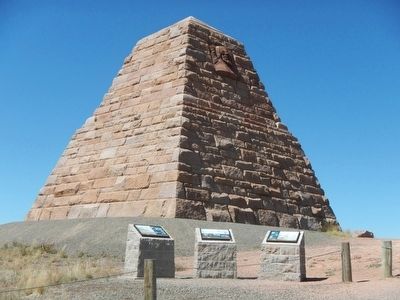
Ames Monument Marker
| On Monument Road near Hermosa Road, on the right when traveling south. |
| Near Interstate 80 at milepost 332, on the left when traveling east. |
| On Monument Road near Hermosa Road, on the right when traveling south. |
| On Interstate 80 at milepost 332, in the median. |
| On U.S. 30, on the right when traveling west. |
| Near Interstate 80 at Elk Mountain Arlington Road. |
| Near W. Davis Street at Bennett Street, on the right when traveling south. |
| On County Route 347 near Interstate 80, on the right when traveling north. |
| On County Route 347 near Interstate 80, on the right when traveling north. |
| On County Route 347 near Interstate 80, on the right. |
| Near Old Highway, 0.1 miles east of County Road 347, on the left when traveling east. |
| On State Highway 374 near Interstate 80, on the right when traveling north. |
| On County Route 347 near Interstate 80, on the right when traveling west. |
| On County Route 347 near 80, on the right when traveling west. |
| On State Highway 789 near Interstate 80, on the right when traveling south. |
| On Brownfield Road (County Route 61) near West Center Street (Business Interstate 25), on the left when traveling south. |
| On Brownfield Road (County Route 61) near West Center Street (Business Interstate 25), on the left when traveling south. |
| On Brownfield Road (County Route 61) near West Center Street (Business Interstate 25), on the left when traveling south. |
| On Brownfield Road (County Route 61) near West Center Street (Business Interstate 25), on the left when traveling south. |
| On Brownfield Road (County Road 61) just south of West Center Street (Business Interstate 25), on the left when traveling south. |
| On Brownfield Road (County Route 61) near West Center Street (Business Interstate 25), on the left when traveling south. |
| On Brownfield Road (County Route 61) near West Center Street (Business Interstate 25), on the left. |
| On Brownfield Road (County Route 61) near West Center Street (Business Interstate 25), on the left when traveling south. |
| Near East Lincolnway near Nation Way, on the left. |
| Near Dey Avenue south of W. Jefferson Road, on the left when traveling south. |
| Near East Lincolnway (Route 30) near Nation Way. |
| Near High Plains Road near Interstate 25, on the left when traveling east. |
| On Capitol Avenue just south of Lincolnway, on the left when traveling south. |
| On Capitol Avenue just south of Lincolnway, on the left when traveling south. |
| On Lincolnway at Capitol Avenue on Lincolnway. |
| On Capitol Ave just south of Lincolnway, on the left when traveling south. |
| Near Lions Park Drive near Carey Avenue, on the right when traveling south. |
| On Coates Avenue near Main Street (County Route 215A), on the right when traveling south. |
| On Parson Street at Interstate 80, in the median on Parson Street. |
| Near Fort Caspar Road, 0.1 miles west of Wyoming Route 258, on the right when traveling west. |
| On East 3rd Street (U.S. 20) 0.1 miles east of Holly Street, on the right when traveling west. |
| On East 3rd Street (U.S. 20) near 3rd Avenue, on the right when traveling west. |
| On Skyline Driver at Newell Drive, on the right when traveling west on Skyline Driver. |
| On S Wyoming Avenue, on the left when traveling south. |
| On Skyline Drive near Newell Drive, on the left when traveling west. |
| On Broadway Street at East 5th Street (Wyoming Highway 336), on the left when traveling south on Broadway Street. |
| On Sibley Circle near East 5th Street (Wyoming Highway 336), on the left when traveling north. |
| On U.S. 189 at Wyoming Highway 351, on the right when traveling south on U.S. 189. |
| On Green River Lakes Road (County Route 650) near Rock Creek Road, on the left when traveling north. |
| On State Highway 374, 0.1 miles west of Lozier Ranch Road, on the right when traveling west. |
| Near Overland Trail near Black Butte Road, on the left when traveling west. |
| Near Overland Trail near Black Butte Road, on the left when traveling west. |
| On South Street near 2nd Street, on the right when traveling east. |
| On South Street near 2nd Street. |
| On South Main Street east of C Street, on the left when traveling east. |
| Near Bear River Drive, 0.3 miles south of Interstate 80, on the right when traveling south. |
| On State Highway 89, 2.6 miles north of Front Street (State Highway 150), on the right when traveling north. |
| On State Highway 150 near County Route 75, on the left when traveling south. |
| Near Bear River Drive, 0.3 miles south of Interstate 80, on the right when traveling south. |
| On State Highway 150 near County Route 75, on the left. |
| On Piedmont Road (County Route 173) near Route 204, on the left when traveling south. |
| On West Main Street at South Railroad Avenue, on the left when traveling west on West Main Street. |
| On U.S. 16 at Tubb Town Road, on the left when traveling east on U.S. 16. |
| On West Main Street (U.S. 16) at South Railroad Avenue, on the left when traveling west on West Main Street. |