On County Route 36 north of Marble Road, on the right when traveling north.
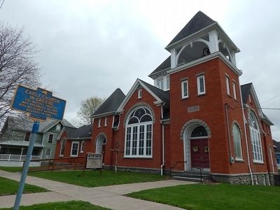
Guilford Center Presbyterian Church has been placed on the National Register of Historic Places in 2004 by the United States Department of the Interior
William G.Pomeroy Foundation
2017 — — Map (db m149752) HM
On County Route 5 at County Route 2, on the left when traveling west on County Route 5.
Free will Baptist Church of German built by Ezra Fuller by 1861 on land given by William and Amana Burnap. Became German town hall 2022 — — Map (db m236034) HM
On New York State Route 26, 0.1 miles east of Pitcher Hill Road, on the left when traveling south.
First Congregational Church of Pitcher
has been placed on the
National Register of
Historic Places in 2001
by the United States
Department of the Interior — — Map (db m146742) HM
On Route 26, 0.1 miles east of Pitcher Hill Road, on the right when traveling south.
Pitcher Baptist Church
has been placed on the
National Register of
Historic Places in 2001
by the United States
Department of the Interior — — Map (db m146738) HM
On New York State Route 8, on the left when traveling north.
Rockdale Community Church has been placed on the National Register of Historic Places in 2005 by the United States Department of the Interior. — — Map (db m169656)
On County Route 21 at Cole Road, on the left when traveling west on County Route 21.
Site of boyhood home of
Brigham Young, Mormon
leader, is one half mile no.
[north] on Cole Rd. The family went on to western New York. — — Map (db m168672) HM
On Mace Chasm Road (County Route 71) 0.2 miles south of New York State Route 373, on the right when traveling south.
Resided here 1885-1916. Machinist, inventor, mill owner & church leader. Union soldier diarist while prisoner during Civil War. — — Map (db m204229) HM
On Lake Shore Road north of Point Au Roche Road, on the right when traveling south.
The Point Au Roche Methodist Episcopal Church stood west of this sign. It was built in the early 1850s on land from the Moore family. This red brick church was the community focal point, a place where people came to worship and socialize. — — Map (db m105857) HM
1906-2012. Daughter of the
Charity of the Sacred Heart
of Jesus sailed from France
in 1905 to start the Academy.
"Tout pour la gloire de Dieu" — — Map (db m132721) HM
On New York State Route 22B south of Mason Street, on the left when traveling south.
As first Methodist Church moved
two miles into the village in 1854.
Merged with Baptist Church in 1937
as Morrisonville Community Church. — — Map (db m194600) HM
On New York State Route 22B, 0.3 miles north of Irish Settlement Road (County Route 32), on the right when traveling south.
Methodist Church built here in 1835
moved to Morrisonville in 1853. First
Clinton County high school-opened 1833
housed in this church from 1835-1867 — — Map (db m194620) HM
On Hallock Hill Road, on the right when traveling east.
Dr. Georgia Harkness
1891-1974. Author, scholar,
activist & clergy member.
First female professor of
theology at a U.S. seminary. — — Map (db m132695) HM
Dedicated on 24 October 1933
in memory of those stationed here
who gave their lives in WWI.
The project was sponsored
by the Churchwomen's League For
Patriotic Service. Costing $22,472.
It was constructed of
weathered brick from a . . . — — Map (db m47944) HM
On Trinity Place west of City Hall Place (U.S. 9), on the right when traveling west.
Plattsburgh's oldest public
building. Reverend John Henry
Hopkins, who authored the hymn
We Three Kings was the rector
here from 1872-1877.
Le plus ancien batiment publique
de Plattsburgh. Ce fut le Reverend
John Henry Hopkins et . . . — — Map (db m115224) HM
On Pleasant Street (New York State Route 22B) at Norrisville Road (County Route 33), on the right when traveling south on Pleasant Street.
Organized in 1846 with service by
Rev. John M. Wever, first minister.
Church built and dedicated in 1847.
Services held until 1980's — — Map (db m194622) HM
On U.S. 9 (New York State Route 9) north of Champlain Drive, on the right when traveling north.
Catholic Summer School of America 1896-1941 on this site. Resort and educational campus with cottages, chapel, dining hall, auditorium & post office. — — Map (db m106622) HM
On New York State Route 295, 1 mile west of New York State Route 22, on the right when traveling west.
1828 -1963 Queechy Methodist Church
1829 Building erected.
1929 September 21-22 One Hundredth Anniversary, Rev. D.A.Cataldo, Pastor.
The following is copied from the booklet published for the celebration.
1964 N.Y. Conf. Minutes, . . . — — Map (db m145309) HM
On New York State Route 9H at Old Lane, on the left when traveling south on State Route 9H.
Congregation established 1716.
Current sanctuary built 1767
NYS Historical Register May 5, 2001
National Register June 21, 2001 — — Map (db m140604) HM
On Wire Road at Half Circle Road, on the right on Wire Road.
The Livingston Memorial Church and lands were donated by Robert Livingston, First Lord of Livingston Manor (1654-1728.).
Born in Ancrum, Scotland, he arrived in the new world in 1673, and is the founder of one of the oldest and most influential . . . — — Map (db m244876) HM
On County Route 7, 0.2 miles east of MacNeil Road, on the right when traveling west.
Connected with Reformed
Protestant Dutch Church.
Known as Stissick, Gallatin,
Ancram, Greenbush, and Vedder
Church. Oldest stone 1770 — — Map (db m165653) HM
On South Street at New York State Route 203, on the left when traveling north on South Street.
Through community generosity
The Friends of St. Peter’s
Leadership of Mary Zander
Benevolence of the
Ellsworth Kelly Foundation — — Map (db m145522) HM
On Main Street (U.S. 11) south of Central Park Place, on the right when traveling south.
Military tract deeded by Revolutionary soldiers to first religious society of Homer, 1805, for meeting house and burial ground
This society organized 1799 — — Map (db m141512) HM
Rev. Samuel S. Day 1808-1871
Roenna Clark his wife 1809-1881
Founders of the American Baptist
Telugu Mission India
Mary M. Day their dau. 1839-1915
Missionary in India 32 y'rs.
The Lone Star Mission and their example
of faith . . . — — Map (db m141474) HM
On South Main Street (U.S. 11) at Albany Street, on the right when traveling north on South Main Street.
Purchased by George W. Samson. Temperance advocate & innkeeper, 1850. Operated as public house kept on "strictly temperance principles." — — Map (db m230141) HM
On Main Street (New York State Route 221) west of Cortland Street/Broome Street (U.S. 11), on the right when traveling west.
Presented to
the First Baptist Church
of
Marathon village,
by
Mrs. D. E. Whitmore,
April 23-1901.
————————————
The Carillon of Bells
is dedicated to
the . . . — — Map (db m131022) HM
On Otisco Valley Road (County Route 103) at Wright Road, on the left when traveling south on Otisco Valley Road.
Site of
Old Log Church
M. E. Church organized 1814,
log church built same year
on Gospel and School Acre
and used until the new
church was built in 1824. — — Map (db m154508) HM
On New York State Route 19, on the left when traveling south.
Congregation formed 1822 promoting union with all
Christians. Gideon Frisbee leased this land to erect a
house of worship to trustees Newell Dodge, Putnam
Farrington, Daniel Frisbee, John Hammond and Clark Sloat later razed. The present church, . . . — — Map (db m137501) HM
On Main Street (New York State Route 97) west of Pennsylvania Avenue, on the right when traveling west.
Memorial
to those who served
in the
World War
Edmund J. Cotter Jr. • Andrew Dunn
John L. Dunn • Charles Esolen
Edward Guinan • Ambrose McGranaghan
Edmund McGranaghan • Eugene McGranaghan
Thomas McGranaghan • Aloysius Meyer . . . — — Map (db m122205) WM
On New York State Route 30 north of Lake Street, on the right when traveling south.
Helen Gould, daughter of the financier Jay Gould became enchanted with the village of Roxbury where her father was born and raised. In 1894 she purchased the property next to the Gould Family church which she had helped to build. Ms. Gould . . . — — Map (db m180669) HM
On Main Street (New York State Route 30) at Lake Street, on the right when traveling south on Main Street.
The Dutch Reformed Church in Roxbury was organized in 1802. In the following years, two church buildings were destroyed by wind and
one by fire. In the 1890s Jay Gould promised aid for a stone church but died before any agreement had been made. So . . . — — Map (db m180671) HM
On Main Street (New York State Route 30) at Spruce Street, on the right when traveling south on Main Street.
A prominent Greek Revival style building in
the Main Street Historic District, the Methodist church was built in 1858. In
1869 the church society built the present commodious parsonage on the lot adjoining the church.
The church building was . . . — — Map (db m180673) HM
On Grand Street west of Main Street, on the left when traveling west.
The first gathering at the Sidney Grove
Campmeeting area was held in 1874.
This bell, created by the Goulds Manufacturing
Company in Seneca Falls, NY, called visitors to
meals and to worship.
In the mid 1940's the services moved to Sky . . . — — Map (db m220635) HM
On Main Street at Churchill Street, on the right when traveling east on Main Street.
Spanish Pentecostal
Church
Built in 1869 as 1st Methodist
church on the former site of
St. Anna’s Episcopal Church.
Rothery File Factory
Built in 1835, the company made
the first wood files in America
starting in 1828 at a . . . — — Map (db m144534) HM
On Salt Point Turnpike (New York State Route 115) at Firehouse lane, on the left when traveling north on Salt Point Turnpike.
Built 1777 by Quakers.
Used in
American Revolution
New York State Chapter
National Society
Daughters of Founders
and Patriots of America
September 21, 1963 — — Map (db m158872) HM
On Salt Point Turnpike (New York State Route 115) north of Firehouse Lane, on the left when traveling north.
Built By the Society of Friends --- 1777
A Committee Was appointed to “Pitch upon a place for the Meeting House” --- 1775
Preparative Meeting Allowed By Nine Partners --- 1776
Monthly Meeting Set Up -- 1782
Division of . . . — — Map (db m158874) HM
On Main Street (New York State Route 52), on the right when traveling west.
Reformed Church of Fishkill, organized 1716, built 1725 Occupied 1776 by New York Provincial Congress, also prison during Revolution. — — Map (db m193584) HM
On Beekman Road (County Route 9), on the left when traveling east.
Church Society of Hopewell organized by 19 members in 1757. The original church built 1764. Present structure started 1833. 225th Anniversary, 1982 — — Map (db m89088) HM
On Albany Post Road (U.S. 9) at East Market Street, on the right when traveling north on Albany Post Road.
Reformed Dutch
Church of Hyde Park
Established 1789 as the
Stoutenburgh Religious
Society. Oldest continuous
Congregation in Hyde Park.
William C. Pomeroy Foundation 2015 — — Map (db m83232) HM
On Albany Post Road (U.S. 9) at East Market Street, on the right when traveling north on Albany Post Road.
Reformed Dutch Church
Hyde Park, New York
Has Been Placed On The
National Register
Of Historic Places
by the United States
Department of the Interior
Organized 1789 Built 1824 — — Map (db m83234) HM
On Franklin Avenue at Millbrook Hollow Lane, on the right when traveling east on Franklin Avenue.
A Wing and a Prayer
Grace Episcopal Church (1901) anchors the upper end of Millbrook's Franklin Avenue. Stucco, stone, turrets, and towers combine in homage to the English Arts and Crafts movement. The interior, though somewhat . . . — — Map (db m140175) HM
On Maple Avenue at Merrit Avenue, on the right when traveling north on Maple Avenue.
Blown Away
The Millbrook Gas and Electric Company (1894-1920), founded by Charles Dieterich, pioneered the use of acetylene in America and provided street lights at 300 village locations. Unfortunately, the gas proved to be highly . . . — — Map (db m140182) HM
On North Avenue at St Joseph Drive, on the left when traveling north on North Avenue.
St. Joseph's Church
Before St. Joseph's Church was completed in 1872, local Catholics had been served by priests who rode out either from Poughkeepsie or Amenia to conduct Mass in an inter-denominational hall. St. Joseph's became . . . — — Map (db m139983) HM
On Old Quaker Hill Road (County Route 66) 0.1 miles north of Kirby Hill Road, on the right when traveling north.
Built and dedicated in 1881
by A. J. Akin. Used by Christ Church since 1895. Moved to
former site of Mizzentop Hotel by Lowell Thomas 1936.
— — Map (db m25020) HM
On Church Road, 0.2 miles south of Quaker Hill Road, on the right when traveling south.
These trees were planted as a Living Memorial to
Thomas E. Dewey
Governor of the State of New York
1943 – 1955
and his wife
Frances Hutt Dewey
Faithful member of the congregation
of Christ Church on Quaker Hill . . . — — Map (db m25018) HM
On Dutcher Avenue at Henry Street, on the left when traveling north on Dutcher Avenue.
First church built in 1809 South Road; second church in 1854 on Main Street. This church erected in 1864. Additions in 1928 and 1960. — — Map (db m24888) HM
On Meeting House Road at Quaker Hill Road (County Route 66), on the left when traveling east on Meeting House Road.
Oblong Meeting House
Of the Society of Friends
Erected in 1742 south of this road
Present building erected in 1764
First effective action against slavery
taken here in 1767
Occupied as hospital January 1779
By Revolutionary . . . — — Map (db m25026) HM
On Meeting House Road at Quaker Hill Road (County Route 66), on the right when traveling east on Meeting House Road.
The First Oblong Friends Meeting House was erected on this site in 1742. It was used as a place of worship until 1764. West of the site was the Friends burial ground. During the fall and winter of 1778 the present meeting house was a hospital . . . — — Map (db m25028) HM
For fifty years a minister
and twenty eight a bishop
in the
Methodist Episcopal Church.
In his ministry he performed
an astonishing amount of labor
and endured many hardships.
He was a pattern of Christian
propriety and integrity . . . — — Map (db m210641) HM
On Vassar Street at Mill Street, on the left when traveling north on Vassar Street.
Organized July 18, 1946
Rev. Dr. Thomas J. Jenkins, Pastor
Charter Members of
Second Baptist Church
Mrs. B. Dukes, K. Roberts, & E. Vaughn
Rev. Robert L. Bruce, Sr., Pastor — — Map (db m130554) HM