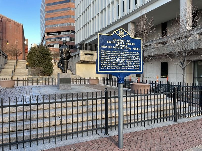
On North French Street south of East 9th Street, on the right when traveling south.
Born a slave, Bishop Peter Spencer was the father of Delaware's independent Black church movement. In 1813, he founded the Union Church of Africans, presently known as the African Union Methodist Protestant Church. The mother AUMP church stood on . . . — — Map (db m215949) HM
On North French Street south of East 9th Street, on the right when traveling south.
Dedicated to the wisdom and works of the Reverend Peter Spencer and his followers who founded here in 1813 the Union Church of Africans - the first Black church in America wholly controlled by descendants of Africans. — — Map (db m215950) HM
On Washington Street just north of West 5th Street, on the right when traveling south.
Tabernacle Full Gospel
Baptist Church
built c. 1866
has been placed on the
National Register
of Historic Places
by the United States
Department of the Interior — — Map (db m217939) HM
On South Market Street (Business U.S. 13) at South Shipley Street, on the right when traveling south on South Market Street. Reported permanently removed.
By the late 1700s the institution of slavery was declining in Delaware. A changing economy and the active efforts of Quakers and Methodists had led to the manumission of many slaves and dramatic growth of the state’s free black population. Though . . . — — Map (db m168333) HM
On South Market Street (Business U.S. 13) at South Shipley Street, on the right when traveling south on South Market Street.
By the late 1700s the institution of slavery was declining in Delaware and there was a dramatic growth in the state's free black population. Demand for slave labor in the Deep South continued to grow and large numbers of free blacks were . . . — — Map (db m215946) HM
On Rosa Parks Drive east of South Market Street (Business U.S. 13), on the right when traveling east.
"For the sake of peace, love, and nothing but that..."
referring to the break with the Asbury Methodist Church of Wilmington,
Reverend Peter Spencer
The August Quarterly, originally known as the Big Quarterly, is the oldest . . . — — Map (db m130484) HM
On Rosa Parks Drive just east of French Street, on the left when traveling west.
On March 10, 1999, this site was officially proclaimed as the Tubman-Garrett Riverfront Park by the Riverfront Development Corporation of Delaware
The Underground Railroad Memorial Plaque was originally erected in 1976 at Spencer Plaza by . . . — — Map (db m184944) HM
On Rosa Parks Drive just west of French Street, on the left when traveling west.
Thomas Garrett, John Hunn, Ezekial Jenkins, Samual D. Burris, and many other Delawareans were prominent abolitionists of pre-Civil War days. Their activities with Harriet Tubman, an escaped slave from Dorchester County, Maryland, frequently referred . . . — — Map (db m184942) HM
On Matt Minker Way just west of Shipyard Drive, on the right when traveling west.
A resident of Delaware for nearly seventy-five years, Judy Johnson was considered the finest third baseman of his day in the Negro Leagues. After attending Howard High School, he played with the Hilldale Club, Homestead Grays and Pittsburgh . . . — — Map (db m191273) HM
On New Castle Avenue (Delaware Route 9) at C Street, on the right when traveling north on New Castle Avenue.
William J. Winchester, after serving 16 years on Wilmington City Council, became the first of his race elected to the Delaware House of Representatives. He served from 1948 until his death in 1952. Herman M. Holloway, Sr., became the first . . . — — Map (db m130328) HM
Near East 7th Street just east of Swedes Landing Road, on the right when traveling east.
A black man named Anthony was among the first permanent settlers of New Sweden. He came to the colony from the West Indies in 1639 aboard the Swedish ship Vogel Grip. Records indicate that Black Anthony became a free man named Antoni Swart, an . . . — — Map (db m228255) HM
On N. Broom St. near W. 20th Street, on the left when traveling north.
Salesianum School, a Catholic high school for young men, stood at 8th and West Streets from its founding in 1903 until its move to this location in 1957. The original "House of Sales" was pioneered by Rev. Charles Fromentin, Rev. James Isenring and . . . — — Map (db m13580) HM
On Lancaster Pike (Delaware Route 48) 0.5 miles west of DuPont Rd, on the right when traveling west.
In 1862 the members of Mother AUMP Church, also known as the Union Church of African Members, purchased property at the corner of Lancaster Ave. and Union St. in Wilmington for the purpose of establishing a cemetery. In 1914 the Church sold the . . . — — Map (db m235732) HM
Near Kirkwood Highway (Delaware Route 2) at Newport Gap Pike (Delaware Route 41), on the right when traveling west.
On June 23, 1903, George White, a black farm laborer, was lynched near this site by a mob of white citizens. After being accused of murdering a white girl on June 16, Mr. White was taken to the New Castle County Workhouse to await trial. On
June . . . — — Map (db m195011) HM
On Sussex Highway (U.S. 13) at Elizabeth Cornish Landing, on the right when traveling south on Sussex Highway.
Elizabeth Smith-Cornish (1937-2018) was a mother, educator, health professional, and community activist who advocated for safe and affordable housing for farm workers in the Bridgeville area. In the 1980s and 1990s, she surveyed households, met with . . . — — Map (db m193786) HM
Near Church Street at 1st Street, on the left when traveling south.
The inadequate condition of schools throughout the nation resulted in a major effort to reform public education following World War I. Delaware was at the forefront of this movement. With the assistance of the Delaware Auxiliary Association and its . . . — — Map (db m193781) HM
On Clayton Avenue (County Route 401), on the right when traveling south.
A "society" of the African Methodist Episcopal Church was established in this area by the 1830's. The first church was purchased in 1857. On February 28, 1890 land was purchased at this site for the purpose of construction of a new church. Annual . . . — — Map (db m37323) HM
On Powell Farm Road (County Road 365), on the left.
The roots of African-American Methodism in this area can be traced to the late 18th century when Methodism pioneers such as Francis Asbury and Freeborn Garrettson traveled locally organizing black “classes” for worship. Over time some groups chose . . . — — Map (db m37844) HM
Near South Bedford Street (Business U.S. 9) north of Zoar Road, on the right when traveling south.
This monument sheds light on the facts that citizens here felt so strongly during the Civil War that they left their state, farms, businesses and families to head south to enlist. Delaware men served in units from Virginia to Texas. The journey . . . — — Map (db m199250) HM
On West Railroad Avenue near East Adams Street, on the left when traveling north.
The roots of African-American Methodism in this community can be traced to the organization of a black “class” within the local Methodist society in the 1790’s. By the 1830’s a group of residents had affiliated themselves with Bishop . . . — — Map (db m49017) HM
On Airport Road at Stevenson Lane, on the right when traveling east on Airport Road.
In the late 19th and early 20th Centuries. Delaware did not have a comprehensive state-wide education system. By 1915, Delaware schools were ranked among the poorest in the country. Worse yet, African American students often attended dilapidated . . . — — Map (db m243080) HM
On Seashore Highway (State Road 18), on the right when traveling east.
Named after the first African-American
president of Delaware State College, the
school opened in October 1950. Funds were
provided in the will of H. Fletcher
Brown a local philanthropist, and by the
State General Assembly. Initially Jason . . . — — Map (db m49021) HM
On West 6th Street (County Road 492) just east of Webb Avenue, on the left when traveling west.
The Paul Laurence Dunbar School educated African American students in Laurel in grades 1-11 from 1921-1965. Constructed as part of philanthropist Pierre S. du Pont's school rebuilding program, the Dunbar School replaced a small wood-framed school in . . . — — Map (db m198843) HM
Named after William C. Jason, the second President of State College for Colored Students (now Delaware State University), Jason Beach was a recreational destination for people of color from the 1930s through the early 1970s. Along with use as a . . . — — Map (db m200985) HM
On Robinsonville Road (Local Road 277) 0.1 miles north of Long Lane, on the left when traveling north.
Rabbit's Ferry School educated Native American and African American students of the Robinsville area from 1920-1965. Built in 1919 through Pierre S. du Pont's school rebuilding program, the school served students in grades 1-8 and later, grades 1-6. . . . — — Map (db m150097) HM
On West 3rd Street just east of Park Avenue, on the right when traveling east.
Built on the banks of the Lewes Canal, this original cottage has a corner fireplace, floor timbers made from salvaged shipwrecks, and an original, and an original cypress shingle exterior. Also, much of the interior is original.
Likely a . . . — — Map (db m190354) HM
On Shipscarpenter Street north of Front Street/Pilottown Road (Delaware Route 267).
The Atlantic Menhaden is a small herring-like fish found in the coastal waters of the Eastern United States. Used by Native Americans to fertilize crops, these oily fish were also used by European settlers to produce fuel for lamps. In the mid-19th . . . — — Map (db m19428) HM
On Pilottown Road (County Road 267) west of West Market Street, on the right.
For nearly 200 years, towns along the Delaware Bay were renowned for shipbuilding centers.
In Lewes, one of the earliest-known shipcarpenters was William Beverly in 1683. Among the last were John and Peter Maull, whose final boat left their . . . — — Map (db m232845) HM
On Pilottown Road just east of Ocean View Boulevard, on the right when traveling east.
St. George AME church was established prior to 1880 on land donated by Peter Lewis, a free black shipbuilder and AME church delegate. Initially, congregants met at the Old Bethel Meeting House, but soon acquired a corn crib to hold services in on . . . — — Map (db m150098) HM
On Cedar Beach Road (Delaware Route 36) 0.2 miles west of Coastal Highway (Delaware Route 1), on the left when traveling east.
Born near this place on a plantation known as “Cedar Town”, Jones moved to Philadelphia in 1762 and in 1784 purchased his freedom. He helped to establish the Free African Society in 1787. A leader of the independent African-American church movement, . . . — — Map (db m38626) HM
On Lakeview Avenue (Delaware Route 36) just north of Kent Place, on the right when traveling north.
On May 17, 1954, the U.S. Supreme Court ruled in the case of Brown v. Board of Education, declaring racially segregated public schools unconstitutional. In August 1954, a petition was submitted to the Milford Board of Education requesting . . . — — Map (db m142583) HM
On Careys Camp Road, on the left when traveling east.
Carey's is one of the few campgrounds still in existence on the Delmarva Peninsula. * The Tabernacle where the
Evangelistic services are held each summer is encircled by 47 tents, occupied only during camp. * Many changes
have been made over . . . — — Map (db m49791) HM
On East Dupont Blvd. (U.S. 113), on the right when traveling north.
On May 2, 1868, the African Methodist
Episcopal Church purchased land west
of Millsboro from John M. Burton and
first church building was soon built.
In 1885, the Church officially changed
its name to Dickersons Chapel to honor
Bishop . . . — — Map (db m48859) HM
On Warwick Cove Way, 0.1 miles west of Gull Point Rd, on the right when traveling west.
On this site was located the Rosedale Beach Hotel and Resort. The hotel and resort operated from the early 1900s to the 1970s. In the pre-integration era of the 20th century, there were very few places for people of color to go for entertainment and . . . — — Map (db m200986) HM
On Union Street (Delaware Route 5) north of Chandler Street, on the right when traveling south.
Bryan Stevenson grew up in Milton, Delaware. A widely acclaimed public interest lawyer, he is the Founder and Executive Director of the Equal Justice Initiative, and has dedicated his career to helping the poor, the incarcerated, and the condemned. . . . — — Map (db m232898) HM
On Broadkill Road (Delaware Route 16) close to Bennett Street, on the left when traveling west.
In an effort to remedy deplorable school facility conditions, philanthropist P.S. du Pont dedicated a substantial portion of his wealth towards the construction of African American schools during the 1920s. Milton Public School #196-C, which stood . . . — — Map (db m142586) HM
On Chestnut Street (State Road 249) near Church Street, on the right when traveling south.
The roots of African-American Masonry in this country
can be traced to the period of the American Revolution,
when founder Prince Hall and others established the
first Masonic Lodge for men of color in Boston,
Massachusetts. By the early 19th . . . — — Map (db m69807) HM
Near 2nd Street at Baltimore Avenue, on the right when traveling south.
There was a public school for white children in Rehoboth Beach as early as 1884. In 1901, that building was replaced by a larger school and by 1908, a two-story school serving elementary through high school grades was built on Rehoboth Avenue . . . — — Map (db m199266) HM
The Frederick Douglass School educated African American students in Seaford from 1922-1966. Professor Robert W. Thomas Sr. served as the only principal during that time. Built as part of philanthropist Pierre S. du Pont's school rebuilding program. . . . — — Map (db m245572) HM
On Market Street just south of High Street, on the right when traveling south.
In October 1856, famed Underground Railroad conductor Harriet Tubman organized what is considered by Tubman scholars to be "one of her most complicated and clever escape attempts." Working at the request of a fiancé who had escaped to Canada, Tubman . . . — — Map (db m138271) HM
On North Street near Clarence Street, on the right when traveling south.
The origin of this congregation can be traced to the organization of a local society of the African Methodist Episcopal Church circa 1852. Desiring a permanent place of worship, the group obtained the old Bochim’s Meeting House and moved it to a . . . — — Map (db m69561) HM
During the early 19th century, people of color in the Concord area both free and slave worshipped at a local Methodist church. After the Civil War, church members decided that African American parishioners should support themselves now that they . . . — — Map (db m245587) HM
Pilot Town is the section of the Hamlet of Concord where many free black families have lived in harmony with the white families since around 1765. It was so named for the many Negro pilots who lived in the area and piloted vessels down the Nanticoke . . . — — Map (db m38662) HM
This is the only documented log slave quarter still in existence in Delaware. This 1 ½ story framed quarter was 24' by 16' with a porch. The interior walls were lath and plaster.
Governor Ross had as many as fourteen slaves. Some probably . . . — — Map (db m71703) HM
In the early 1800s the headquarters of the notorious Cannon/Johnson Kidnapping Gang was located close to this site. After the importation of African slaves was legally outlawed in 1808, demand for slave labor in the expanding states of the Deep . . . — — Map (db m67262) HM
On Atlanta Road, on the right when traveling west.
Founded in 1846 and part of Seaford's rural community for over 160 years, Wesley United Methodist Church was originally organized circa 1861 in a local schoolhouse. On November 18 of that same year, Henry Little donated a half-acre of land to be . . . — — Map (db m245615) HM
148 entries matched your criteria. Entries 101 through 148 are listed above. ⊲ Previous 100