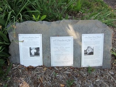
Ivy Chapel Union Church was built in I880 on Coffee Road in Bedford County, Virginia. The chapel was named for nearby Ivy Creek. It was known as a “union church” because it served as a house of worship for Baptist, Methodist, and . . . — — Map (db m74065) HM
Bedford County was probably named for the English statesman John Russell, fourth duke of Bedford. Russell, as secretary of state for the Southern Department from 1748 to 1751, had general supervision of colonial affairs. Bedford was formed from . . . — — Map (db m234611) HM
Col. William Elisha Peters, 21st Virginia Cavalry, C.S.A., is buried in the cemetery to your left. He was born on August 28, 1829, in Bedford County, Virginia, attending New London Academy there, then entered Emory and Henry College in 1846, . . . — — Map (db m211804) HM
[Front Plaque, Facing East.]
This monument was erected in the year 1909 in commemoration of the Battle of Point Pleasant, fought at the mouth of the Great Kanawha River, now in West Virginia, October 10, 1774. Between twelve hundred and . . . — — Map (db m22553) HM
This is one of the original service plazas for the nation's first long-distance superhighway. On October 1, 1940, the Turnpike opened, stretching 160 miles from Irwin to Carlisle. The Turnpike Commission had been created in 1937; construction . . . — — Map (db m308157) HM
Mary Shirley, who was born on 17 February 1762, married William McGuire on 23 February 1778 in Virginia. During the Revolutionary War William and Mary McGuire with son Michael were taken prisoner on 26 June 1780 and moved from Virginia to Montreal, . . . — — Map (db m262420) HM
On the evening of June 15, 1864, the lead element of Union Gen. David Hunter’s 18,000-man army arrived here and cam near Avenel. The main force arrived the following morning and started destroying the Virginia and Tennessee Railroad tracks, burning . . . — — Map (db m41408) HM
Nearby are buried several prominent area settlers and their descendants. Col. William Callaway, in 1755 one of the first two members of the Virginia House of Burgesses from Bedford County, donated the hundred acres of land on which the town of New . . . — — Map (db m65605) HM
On May 26, 1864, Union Gen. David Hunter marched south from Cedar Creek near Winchester to drive out Confederate forces, lay waste to the Shenandoah Valley, and destroy transportation facilities at Lynchburg. His raid was part of Gen. . . . — — Map (db m256761) HM
The land that is now Bedford Plantation subdivision was once part of 640 acres owned by Julian Bedford (1825-1879), and Virginia R. Kenney
Bedford (1830-1916), who settled in 1851 at what was
to be known as the Bailey Station community.
They . . . — — Map (db m149053) HM
Appomattox County. Appomattox County was named for the Appomattox River, which runs through the county. The river is named for the Appamattuck tribe, which lived near the mouth of the river. The county was formed from parts of Buckingham, . . . — — Map (db m74018) HM
Oakwood Plantation was built here ca. 1780 for Capt. William Terry, a Revolutionary War officer. His grandson William R. Terry was born at Oakwood, graduated from the Virginia Military Institute, and became a Confederate captain in the spring of . . . — — Map (db m298703) HM
About two miles southwest is Mount Airy, a plantation house built ca. 1800 for Col. Thomas Leftwich (1740-1816). The two-story frame house retains much of its Federal-style woodwork. Leftwich served in the Seven Years' War and was a captain of the . . . — — Map (db m305734) HM
(preface) On May 26, 1864, Union Gen. David Hunter marched south from Cedar Creek near Winchester to drive out Confederate forces, lay waste to the Shenandoah Valley, and destroy transportation facilities at Lynchburg. His raid was . . . — — Map (db m256765) HM
Served as a county magistrate, member of the House of Burgesses, and commander of the Bedford County militia and mounted riflemen.
In July 1780, Colonel Lynch helped break up a Tory plot to capture Virginia for the British. The Tory leaders . . . — — Map (db m299522) HM
Served as a county magistrate, member of the House of Burgesses, and commander of the Bedford County militia and mounted riflemen.
In July 1780, Colonel Lynch helped break up a Tory plot to capture Virginia for the British. The Tory leaders . . . — — Map (db m310253) HM
Campbell County
Campbell County was created from Bedford County by the Virginia General Assembly in 1781 and named for Gen. William Campbell, one of the heroes of the Battle of King's Mountain in 1780. The county seat is Rustburg. British Lt. . . . — — Map (db m306964) HM
This structure was built in 1878 by King Iron and Bridge Co. in Bedford County. It remained in use until 1971. It is the oldest metal bridge in Virginia. — — Map (db m270423) HM
House built circa 1810 by Samuel Shrewsbury (1763-1855) on a 704 acre tract of land received from Colonel John Dickinson. Sandstone and hewn hardwood logs used in construction were obtained locally from the land. Shrewsbury, a revolutionary . . . — — Map (db m76882) HM
Born In Thaxton, Bedford County, Lettie Pate
Whitehead Evans played a major role in the early
distribution of bottled Coca-Cola. She was one
of the first women members of the board of
directors of a major American corporation,
serving on the . . . — — Map (db m69922) HM
The Lynchburg and Salem Turnpike Co. was incorporated in 1818 to build a turnpike from Lynchburg west to Salem. The road reached Liberty (now Bedford) in 1828 and was completed to Salem in 1836. In Bedford County, covered bridges spanned the Big . . . — — Map (db m18830) HM
Poplar Forest, Thomas Jefferson's Bedford County retreat house and plantation, is 1.5 miles south of here. Jefferson’s wife, Martha Wayles Skelton, inherited the property in 1773, and Jefferson called it “the most valuable of my possessions.” He . . . — — Map (db m310345) HM
Botetourt County. Area 548 Square Miles. Formed in 1769 from Augusta, and named for Lord Botetourt, Governor of Virginia, 1768–1770. Buchanan was the western terminus of the noted James River and Kanawha Canal.
Bedford . . . — — Map (db m57734) HM
This small bridge is the oldest metal truss bridge and the sole survivor of its type in Virginia. It was built in 1877-78 over Stony Run in nearby Bedford County and was subsequently moved to a site over Roaring Run, also in Bedford County, where it . . . — — Map (db m228044) HM
In 1781, British Gen. Charles Cornwallis ordered cavalry commander Lt. Col. Banastre Tarleton to raid Southside Virginia to seize or destroy private and public supplies of ammunition, clothing, and food. On 9 July, Tarleton left Cobham in Surry . . . — — Map (db m166813) HM
Born October 9, 1720, in County Donegal, Ireland. The second son of John and Margaret Lynn Lewis. He served in the early campaigns on the American frontier. Wounded at Fort Necessity in 1754. Commanded the Big Sandy Expedition in 1756. With Forbes . . . — — Map (db m20791) HM
In November 1843 former slave Frank Lambert, along with 29 other former slaves, purchased 265.5 acres of land in Morgan Township. These African American settlers had once belonged to Charles Lambert Jr. of Bedford County, Virginia, but had been . . . — — Map (db m243194) HM
The trustees of Randolph-Macon College, a Methodist institution in Ashland, opened Randolph-Macon Academy here in 1890. A preparatory school for boys, it attracted local students as well as boarders from other regions of Virginia and beyond. The . . . — — Map (db m298697) HM
"Let not the knives of pro-slavery men be sheathed while there is one abolitionist in the Territory." —Squatter Sovereign proslavery newspaper in Atchison, Kansas Territory, June 10, 1856
On this site at dawn on June 2, 1856, the . . . — — Map (db m20051) HM
Lynchburg’s hospital center was staffed with over 50 military surgeons reporting for duty from all parts of the Confederacy.
The War Department appointed Lynchburg physician, William Otway Owen, as Surgeon-in-Charge of Lynchburg’s large medical . . . — — Map (db m74051) HM
Over two days, June 27-28, 1864, dusty columns of approximately 5,000 exhausted Union cavalrymen, with artillery, wagons, and ambulances, passed this spot near Smoky Ordinary. Gen. James H. Wilson's division led the way, with Gen. August V. . . . — — Map (db m310188) HM
British Lieutenant Colonel Banastre Tarleton was tasked by Lord Charles Cornwallis to raid Southside Virginia and destroy ammunition, clothes, and "stores of any kind" destined for Continental military use.
Tarleton's Assignment
The . . . — — Map (db m182521) HM
From June 24th to June 27th, the Union Army of the Cumberland had moved flawlessly to maneuver the Confederate Army of Tennessee out of its position south of the Highland Rim. As Rosecrans would later say, only heavy rains had prevented a complete . . . — — Map (db m207282) HM
In June 1864, to deny Gen. Robert E. Lee the use of the South Side R.R. and the Richmond and Danville R.R., Gen. Ulysses S. Grant sent Gen. James H. Wilson and Gen. August V. Kautz south of Petersburg on a cavalry raid to destroy track and . . . — — Map (db m14765) HM
This property has been
placed on the
National Register
of Historic Places
by the United States
Department of the Interior
Green-Evans-Hudgens House
circa 1858 — — Map (db m196474) HM
This Monument Was erected by the liberality of the Citizens of the County of Sumner to the memory of her Patriotic Sons: who sacrificed their lives in the defense of the Flag of their country in the war with Mexico. In 1846. 1847 & 1848. . . . — — Map (db m85162) WM
Thin black lines indicate changes in relevance. Between each pair of lines entries are ordered geographically but all have the same relevance.
* Inflectional forms of words are their plurals, singulars, and possessives as well as gramatical tenses and similar variations.