Nottoway County. Area 310 Square Miles. Formed in 1788 from Amelia, and named for an Indian tribe. Tarleton passed through this county in 1781. Here lived William Hodges Mann, Governor of Virginia 1910-14.
Dinwiddie . . . — — Map (db m286889) HM
Nottoway County. Area 310 square miles. Formed in 1788 from Amelia, and named for an Indian tribe. Tarleton passed through this county in 1781. Here lived William Hodges Mann, Governor of Virginia 1910-14.
Dinwiddie . . . — — Map (db m31053) HM
Dedicated in 1887 to the Confederate war dead, this nondenominational chapel served as a place of worship and assembly for the R.E. Lee Camp Confederate Soldiers' Home, a residential complex for indigent Southern veterans. Designed in the . . . — — Map (db m296326) HM
Prior to the Civil War, Dinwiddie County was home to several private academies for those who could afford to pay for their education. While it was mostly affluent males who were educated, Pegram’s Academy, Female Academy, Girard Heartwell . . . — — Map (db m26834) HM
Russell Grove Presbyterian Church and the Russell Grove School were established as a result of the efforts of Mrs. Samantha Jane Neil, a Presbyterian missionary and teacher of African-American children after the Civil War. At first the school . . . — — Map (db m28927) HM
Southside Virginia Community College has two campuses: the Christanna Campus in Alberta, which opened in 1970, and the John H. Daniel campus in Keysville, which opened in 1971. The college is part of the statewide system of community colleges . . . — — Map (db m30868) HM
In 1714, at Governor Alexander Spotswood’s urging, the Virginia General Assembly funded the Virginia Indian Company, charged with building a fort on the banks of the Meherrin River in what would become Brunswick County. The fort would provide . . . — — Map (db m20197) HM
Saint Paul’s College began as a small parochial school founded by a newly ordained Episcopal deacon, the Rev. James Solomon Russell. Born into slavery, Russell attended seminary school in Petersburg. Within a year of graduation he had managed . . . — — Map (db m30870) HM
Union Grove School is representative of the many one-room schools for African-American students in Buckingham County and throughout the area. The African-American members of the community built Union Grove around 1925, and like most schools, . . . — — Map (db m21148) HM
North of this sign is the birthplace of Dr. Carter G. Woodson. Dr. Woodson was born December 19, 1875, to former slaves, James Henry and Eliza Ann Riddle Woodson. Young carter left Buckingham to work in West Virginia when he was 17 years old. . . . — — Map (db m31608) HM
Beginning in 1937, Ambassador and Mrs. David K. E. Bruce anonymously gave money to 11 sites in Southside Virginia to build libraries. The Bruce libraries, as they were called, became the first public libraries to allow access to African . . . — — Map (db m31019) HM
Southside Virginia Community College has two campuses: the Christanna Campus in Alberta, which opened in 1970, and the John H. Daniel campus in Keysville, which opened in 1971. The college is part of the statewide system of community colleges . . . — — Map (db m31025) HM
After the Civil War, in the Red Oak area of Charlotte County, many freed slaves were welcomed to worship at Antioch Baptist Church, a traditionally white church. The Antioch congregation helped raise money to build Salem Baptist Church in . . . — — Map (db m30999) HM
Virginia State University was chartered by the Virginia legislature in 1882 as the Virginia Normal and Collegiate Institute. Delegate Alfred W. Harris, an African-American attorney in Petersburg, championed the charter and supported it . . . — — Map (db m26005) HM
Parents in the Cartersville area of Cumberland County met in 1909 to discuss the need for a centralized high school to replace the one-room schools serving white children in the area at that time. The county Superintendent of Schools led the . . . — — Map (db m31609) HM
Julius Rosenwald, a former president of Sears, Roebuck & Co., continued the efforts made by numerous philanthropists to bring education to African Americans in the South. During the early 1900s, funding for schools was scarce; the South had half . . . — — Map (db m21159) HM
Jackson Davis, an educational reformer and amateur photographer, was born in Cumberland County, VA, to William Anderson and Sally Wyatt (Guy) Davis on September 25, 1882. He attended the public schools of Richmond, VA, and received his B.A. . . . — — Map (db m21150) HM
In 1938 the Virginia Assembly chartered a residential care facility for mentally retarded African-American males between 8 and 21 years of age. The Petersburg State Colony for the Negro Insane, as it was named, was located on the present site . . . — — Map (db m23455) HM
In 1911 a group of Dinwiddie County’s African-American residents established the Rocky Branch School in Sutherland. The school was a typical two-room schoolhouse. It had been moved from original location across from Ocran Methodist Church on . . . — — Map (db m26833) HM
In 1872 the Banister Baptist Association built a private African-American training school in Halifax County. Originally the campus consisted of four wooden buildings and a dormitory. The school year was six months, and the grades went only as . . . — — Map (db m30988) HM
Many churches in the second half of the 19th century and early part of the 20th century helped fill African Americans’ need for schooling. Frequently the church would raise funds to build the school, with county governments occasionally . . . — — Map (db m30961) HM
Determined to provide elementary education for young African Americans, the Rev. Parham B. Ragland started a school in his backyard some time around 1875. Though the "Backyard School" was private, Rev. Ragland was able to garner financial . . . — — Map (db m30970) HM
In 1880 a German Lutheran minister, the Rev. W. R. Buehler, a well-educated man who had worked for five years as a missionary in Africa, moved with his family to Green Bay, Virginia. He had not been in Green Bay long when the black community, . . . — — Map (db m31035) HM
On May 13, 1947, several African-American leaders in Lunenburg County met at First Baptist Church in Victoria to discuss the need for a centrally located building large enough to accommodate countywide gatherings and educational activities . . . — — Map (db m31856) HM
Boydton Academic and Bible Institute was opened in 1879 in building that had been abandoned by Randolph-Macon College when it moved to Ashland in 1868. Dr. Charles Cullis, a humanitarian from Boston, purchased the property in 1878 and opened . . . — — Map (db m30917) HM
Thyne Institute was established by Rev. J.Y. Ashenhurst, United Presbyterian Church, and a group of local citizens to provide an opportunity for African Americans (known as “freedmen” in the late 1800s) to obtain an education. In 1876 73 . . . — — Map (db m31003) HM
The Blackstone Female Institute was conceived in 1891 by George Pierce Adams, a Blackstone merchant, and Joshua Soule Hunter, a Methodist minister. Originally designed as a school to prepare young female students to enter Randolph-Macon . . . — — Map (db m31045) HM
Mt. Nebo Church was founded shortly after the Civil War in 1867. A northerner named Mr. Rickets bought the place called Oak Hill and began preaching to a group of African Americans at this place in the woods. The audience increased as people . . . — — Map (db m20242) HM
When the Russell Grove School in Amelia County grew too big for its building, land was found in Nottoway County near Burkeville for a new school. Built in 1892 to educate African-American girls, the new school was named Ingleside Seminary. It . . . — — Map (db m31042) HM
Petersburg established a public school system in 1868, two years before the state’s mandate. Colored Elementary School #1 was conducted in the old church building of the African Baptist Church, which stood to your left. The building had been . . . — — Map (db m26011) HM
Disrupted by the convulsions of the First World War, efforts to replace the increasingly inadequate Peabody School on Fillmore Street stretched out from 1913 until 1920, when the new Peabody-Williams School opened on Jones Street. Charles . . . — — Map (db m26012) HM
Beulah African Methodist Episcopal (AME) Church was founded in 1868. Originally, it was known as The Colored Methodist Church of Farmville. The original wooden-framed building was destroyed, by fire in 1898. The cornerstone on the present . . . — — Map (db m31318) HM
Founded on March 5, 1839 as the Farmville Female Seminary Association, Longwood is one of the oldest colleges originally for women in the country. In 1842 the cornerstone was laid for the first true college building, which is today known as . . . — — Map (db m31316) HM
The First Baptist Church was organized in 1866 as an outgrowth of the predominantly white Farmville Baptist Church. In 1949, following the death of the Rev. C. H. Griffin, the Church voted unanimously to call his son, L. Francis Griffin, as . . . — — Map (db m31310) HM
Hampden-Sydney College, in continuous operation since November 10, 1775, was established “to form good men and good citizens.” One of the few remaining all-male colleges, it was named for John Hampden (1594-1643) and Algernon Sydney . . . — — Map (db m31324) HM
In 1954, after the Supreme Court ruled in Brown vs. the Board of Education of Topeka, that United States schools must integrate, Senator Harry S. Byrd and several Virginia governors followed the policy of “massive resistance.” Integration was . . . — — Map (db m31321) HM
On this site of the former R.R. Moton High School, the actions of some brave African-American students to achieve equal educational opportunities for blacks eventually led to the end of legal segregation in American public schools.
Moton . . . — — Map (db m31319) HM
Virginia State University was founded on March 6, 1882, when the legislature passed a bill to charter the Virginia Normal and Collegiate Institute. The bill was sponsored by Delegate Alfred W. Harris, a Black attorney whose offices were in . . . — — Map (db m149618) HM
Mayfield, a classic example of Colonial Virginia architecture and the oldest standing brick house in Dinwiddie County, was once the manor house of a 1400-acre plantation. The probable builder and first owner was Robert Ruffin, friend of George . . . — — Map (db m208553) HM
African American Medal of Honor Recipients Memorial
The Medal of Honor takes its place in our country as the highest award for military valor. The honor, awarded by the President in the name of Congress, may only be accorded an . . . — — Map (db m173924) HM WM
Bourland Jolly (a.k.a. Boling Jolley) (1766-1844) born in Dinwiddie County, Virginia where he enlisted in the VA. Militia in 1781. He was enlisted by a Captain Connelly and later served under a Col. Lucas at the Siege of Yorktown. After . . . — — Map (db m292353) HM WM
On the morning of Monday, April 3, 1865, part of Confederate General Robert E. Lee's Army of Northern Virginia briefly halted here. The day before, a series of Federal attacks had broken through Lee's lines at Petersburg and ended the siege there. . . . — — Map (db m311949) HM
Butterwood Chapel, one of three Anglican chapels constructed in Dinwiddie County in the 18th century, was built by 1763 on or near this site. It probably was the first church built after the creation of Bath Parish in 1742. The Reverend Devereux . . . — — Map (db m31054) HM
Sallie Jones Atkinson, prominent educator and community leader in Dinwiddie County and her husband, John Pryor Atkinson, gave the land on which Sunnyside High School was built in 1911. By her vision, tireless industry, and determination, the school . . . — — Map (db m26838) HM
A Scenic River Rich in History
Appomattox County to Hopewell
The Hopewell Riverwalk is located on the Appomattox River, just west of its confluence with the James River at City Point. The Appomattox River originates in Appomattox . . . — — Map (db m291771) HM
(panel 1) "The work of removing the bodies of Federal soldiers, who died here during the war, was commenced on yesterday. Their remains will be taken from this place to City Point for re-interment." Lynchburg Daily Virginian Saturday, . . . — — Map (db m156593) HM
This monument stands as an enduring tribute to all of Virginia's women, both renowned and unrecognized, who have shaped over 400 years of our culture, our country, and our great Commonwealth.
❶ Anne Burras Laydon . . . — — Map (db m216636) HM
This monument stands as an enduring tribute to all of Virginia's women, both renowned and unrecognized, who have shaped over 400 years of our culture, our country, and our great Commonwealth.
❶ Anne Burras Laydon . . . — — Map (db m216637) HM
This historic church was founded in 1827 by the Rev. Ebenezer MacGowan (1767 - 1850). He gave the land and built the first church of logs. He was born in London, England. The son of the Rev. John MacGowan, a contemporary of John Wesley, at the age . . . — — Map (db m263614) HM
Late on the morning of Monday, April 3, 1865, part of Confederate General Robert E. Lee’s Army of Northern Virginia briefly halted here at the Chesterfield County seat. The day before, a series of Federal attacks had broken through Lee’s lines at . . . — — Map (db m19518) HM
The Rev. Dr. Martin Luther King Jr. spoke at Mount Level Baptist Church on 28 March 1962 during a "People to People" tour of communities in southern Virginia. King and other official of the Southern Christian Leadership Conference made stops between . . . — — Map (db m310182) HM
Sapony Episcopal Church stands approximately 1.5 miles to the north. This simple frame building was first constructed in 1725-1726. The Rev. Devereux Jarratt served as rector here and at two other congregations in Dinwiddie County from 1763 until . . . — — Map (db m26841) HM
Welcome to the Banks House. This 18th-century home was typical of other upper-middle class farms in Dinwiddie County, except for 24 hours on April 2-3, 1865 when it became military headquarters for Lieutenant General Ulysses S. Grant. From here, . . . — — Map (db m11944) HM
Petersburg is in the midst of a downtown renaissance, fueled by the arts and driven by the creative spirit of the community. Historically a center of culture and trade for the region, Petersburg’s abundant natural resources and rich history are . . . — — Map (db m57369) HM
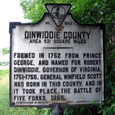
Dinwiddie County. Area 521 Square Miles. Formed in 1752 from Prince George, and named for Robert Dinwiddie, Governor of Virginia 1751-1756. General Winfield Scott was born in this county, and in it took place the battle of Five . . . — — Map (db m62404) HM
Sussex County. Area 515 Square Miles. Formed in 1753 from Surry, and named for an English county. Cornwallis passed through this county in 1781.
Dinwiddie County. Area 521 Square Miles. Formed in 1752 . . . — — Map (db m69937) HM
Dr. Gladys B. West paved the way for the Global Positioning System (GPS) that has revolutionized global society. She is a pioneer in the use of complex mathematical programming to generate accurate models of the earth's shape.
Dr. . . . — — Map (db m213297) HM
Born near here in Dinwiddie County in 1818, Elizabeth Hobbs Keckley, or Keckly, was a
dressmaker and abolitionist. She lived as a slave in Virginia and North Carolina but
eventually bought her freedom in 1855. By 1860 she had relocated to . . . — — Map (db m79076) HM
Prior to the Civil War, Dinwiddie County was home to several private academies for those who could afford to pay for their education. While it was mostly affluent males who were educated, Pegram's Academy, Female Academy, Girard Heartwell's . . . — — Map (db m180010) HM
A public school operated here as early as the 1880s. In 1907, three other one-room schools nearby were consolidated here as Darvills Graded School, which was expanded and made a high school in 1913. It was the heart of community activities, notably . . . — — Map (db m31055) HM
(front)
In Memoriam
Battle of Dinwiddie Court House
Dedicated to the Confederate and Union soldiers who gave their lives in the Battle of Dinwiddie Court House, sometimes called Chamberlain’s Bed, in the last brief victory of the . . . — — Map (db m17670) HM
1 - A Desolate Landscape
The Boisseau family became the owners of this tract in the early nineteenth century. William Boisseau developed the property into a plantation he named Tudor Hall. By 1864 much of the acreage had been cleared for . . . — — Map (db m285490) HM
Beginning on June 15, 1864, less than three miles east of where you are standing, 18,000 Union troops attacked the Confederate line of defensive fortifications surrounding the city. When all attempts to take the city by direct assault failed by June . . . — — Map (db m175034) HM
Thin black lines indicate changes in relevance. Between each pair of lines entries are ordered geographically but all have the same relevance.
* Inflectional forms of words are their plurals, singulars, and possessives as well as gramatical tenses and similar variations.