On Andrew Pickens Circle, on the right when traveling north.
Andrew Pickens Ranger District Side
The Ranger District was named for Andrew Pickens, an able commander of South Carolina's rebel militia during the American Revolution. Born of Scots-Irish immigrants near Paxtang, Pennsylvania, Pickens . . . — — Map (db m14210) HM
[Front]:
This school, often called Retreat Colored School, was built in 1923 for the African-American students in and near Westminster. A two-room, two-teacher, elementary school, it was built by local builder William Walker Bearden of . . . — — Map (db m53235) HM
On East North Broad Street, on the right when traveling north.
[Front]:
Newberry College, founded in 1856, moved here from Newberry in 1868 and remained in Walhalla until 1877, returning to Newberry for the opening of the 1877-78 academic year. The Lutheran college struggled during the Civil War and . . . — — Map (db m13991) HM
On West Main Street, on the left when traveling west.
In appreciation of
the Oconee County Veterans Committee
for establishing this park in honor
Oconee County soldiers who served
so that we could be free. — — Map (db m14456) HM
[Front Side]:
The Cherokee sided with the British during the American Revolution, and in 1776 Maj. Andrew Williamson's S.C. militia destroyed their "Lower Towns" in what is now S.C. He then cooperated with the N.C. militia in expeditions . . . — — Map (db m14351) HM
The history of Stumphouse Tunnel is as rich as the surrounding land and carries with it stories of dreams, failures, hardships, and opportunities. The dream was to develop a railroad line from Charleston, South Carolina to Cincinnati, Ohio. The . . . — — Map (db m15041) HM
Oconee Station
The South Carolina Frontier Experience
Oconee station & the William Richards House
This site was a frontier outpost and a meeting place between European American and Cherokees of this region during the late . . . — — Map (db m14372) HM
On Bethel Church Road (State Road S37-198) just north of Lecroy Road (State Road S37-449), on the left when traveling north.
Bethel Presbyterian Church, the oldest church in continuous existence in Oconee County, was founded in 1805 by General Andrew Pickens, one of South Carolina’s most notable Revolutionary War heroes. General Andrew Pickens, along with others found . . . — — Map (db m183264) HM
On Cherry Street Extension (State Highway 115), on the right when traveling east.
Born in 1840, Colonel Simpson, lawyer, farmer, and legislator, drafted and executed Thomas Green Clemson's will, establishing Clemson Agricultural College in 1889. Simpson was first president of the college's board of trustees and once owned land . . . — — Map (db m9682) HM
On West South 4th Street, on the left when traveling south.
On February 4, 1938, Mrs. Ploma M. Adams, owner of this farm, assisted by the Upper Savannah Soil Conservation District, initiated the first Farm-Conservation Plan of any district in America. — — Map (db m26287) HM
On North Lewis Street at Griffin Street, on the right when traveling north on North Lewis Street.
Quilter: Mrs. Una Welborn Sponsor: Hagood-Mauldin House The Carpenter's Wheel was a pattern used in the Underground Railroad to guide slaves to freedom. It also represents the fine carpentry that went into the building of the house in . . . — — Map (db m234335) HM
On West Oak Highway (State Highway 24), on the right when traveling north.
Before the building was constructed, the Pickens Circuit of the Methodist conference used the grounds for their camp meetings. Throughout the years the church changed circuits from Pickens to Townville to Westminster and back to Townville. Being in . . . — — Map (db m53690) HM
The town of Pickens was established as the center of government for the newly established Pickens District. The county was originally part of the Pickens District, today's Pickens and Oconee Counties. Its center of government, Pickens Court House, . . . — — Map (db m11774) HM
The Hagoods and the Mauldins
James E. Hagood, son of local farmer and landowner Benjamin Hagood, built this house in 1856 in the town of Pickens Court House, about 14 miles west of here. The house was moved to this site in 1868. James . . . — — Map (db m11783) HM
Founded August 14, 1873, as
"Seneca City," and chartered on
March 14, 1874, the town of
Seneca was named for an Indian
village on the Seneca River.
Its location was determined by
the junction of the Blue Ridge
Railroad and the . . . — — Map (db m13969) HM
On West Oak Highway (State Highway 24) at Townville School Road, on the right when traveling east on West Oak Highway.
[Front]
This church, founded as Nazareth on the Beaverdam Presbyterian Church, was established in 1803. It met in members’ homes until they paid $1.50 for a half-acre tract and built a small frame church 2.5 mi. E. The founders’ cemetery . . . — — Map (db m39349) HM
Near Stumphouse Tunnel Road east of State Highway 28, on the right when traveling north.
The Legend
Tradition relates that the waterfall is named for Issaqueena, a Creek maiden captured by the Cherokee. Of the many legends, the most popular, based on Rev. J.W. Daniels' 1898 poem, “Cateechee of Keowee,” told how Issaqueena was . . . — — Map (db m185423) HM
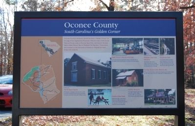
Located along the edge of the Blue Ridge Mountains, the history of Oconee County dates back to when the area was predominately inhabited by the Cherokee.
Following the American Revolution, and after settlement increased in South Carolina's . . . — — Map (db m64805) HM
On E Wade Hampton Boulevard (U.S. 29) 0.1 miles south of J. Verne Smith Parkway, on the right when traveling north.
Anthony Hampton
Feb. 3, 1715 - July 1776
with
wife, son Preston, and grandson
massacreed by Cherokee Indians,
July 1776
Tyger River, Spartanburg
District, S. C.
Maj. Gen. Wade Hampton
1752 - 1835
Col. Wade Hampton,
1791 - 1858 . . . — — Map (db m10400) HM
Near Stumphouse Tunnel Road near State Highway 28, on the right when traveling west.
[Listed from north to south]
Oconee Located on the edge of the Blue Ridge Mountains, Oconee County is known for nature-based activities such as boating, birding, backpacking, and camping
Pickens Pickens County has many beautiful . . . — — Map (db m185421) HM
On this spot, under a great oak three which stood here, the first meeting of the Board of Trustees of the Clemson Agricultural College was held May 2, 1888.
The following is a copy of the record of that meeting.
"Fort Hill, Oconee County, . . . — — Map (db m9564) HM
On Hagood Mill Road, on the right when traveling east.
[Front]:
During most of its life, the Hagood Mill was a busy center of commerce. The Products of Industry Census records Hagood Mill as having produced 2,500 bushels of meal (140,000 pounds) and 200 bushels of flours (11,200 pounds) in the . . . — — Map (db m20117) HM
Russell House
This was a busy Appalachian farmstead in the late 1800's and early 1900's. You could hear the laughter of children playing in the creek, lowing cattle and clucking chickens as they searched for food. Ganaway Russell built a . . . — — Map (db m20978) HM
Old Pickens Church
A Presbyterian congregation was probably organized in the 1840s. It is impossible to fix an exact date because the church records were destroyed in a fire around the turn of the 20th century. Construction on the church . . . — — Map (db m13179) HM
A church/meeting house for early immigrants
of Scotch-Irish and English descent
who settled in the area.
Presented by
Col. John Robins Chapter
National Society Colonial Dames 17th Century
In Honor of
Mrs. Kay Patricia Hunt Alford . . . — — Map (db m121930) HM
On West Main Street (State Highway 93) at Bank Street, on the right when traveling west on West Main Street.
[Front]:
The town of Central, chartered in 1875, grew up along what is now Gaines Street. The post office was called Five Mile from 1851 to 1871. In the 1870s the Atlanta & Richmond Airline Railway built its depot, hotel, offices, and . . . — — Map (db m29834) HM
On Church Street, on the right when traveling south. Reported unreadable.
The Central Heritage Society purchased the Morgan House in 1995 as headquarters for the Central History Museum. Several of the rooms are almost exactly as Jessie and Jennie Morgan left them, while others focus on Central, South Carolina history. . . . — — Map (db m15559) HM
On Broadway Street (State Highway 37-203) at Palmetto Avenue, on the left when traveling east on Broadway Street.
The citizens of Newry had been having church service in the hall over the company store for a good while after the village was built. They petitioned the company to allow them to start a building fund, which was agreed to. However, the management . . . — — Map (db m56561) HM
Near Bumgardner Drive at California Drive, on the right when traveling south.
Dedicated on October 15, 2019, this plaque celebrates and commemorates 100 years of devoted service to children and families. Founded by the South Carolina Daughters of the American Revolution to educate mountain children, Tamassee DAR School . . . — — Map (db m241194) HM