On Lake Avenue just north of Frazee Street, on the right when traveling north.
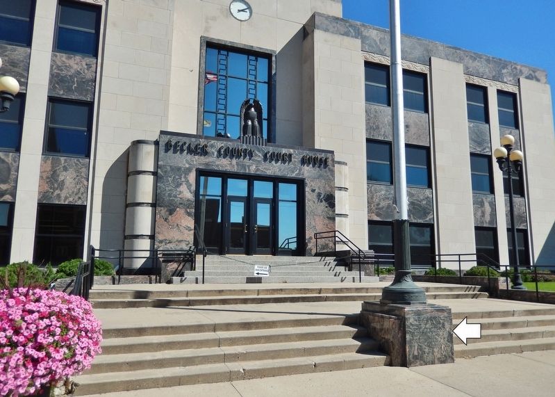
This courthouse constructed by Becker County in cooperation with the Works Progress Administration of the Federal Works Agency S. L. Stolte • State Administrator Harry Phinney • District Manager W. R. Koester • District Engineer Albert . . . — — Map (db m209093) HM
On 2nd Street East just east of Sibley Street, on the left when traveling east.
was especially built for the retail, wholesale hardware business Henry Hudson Pringle established at Hastings in 1856. Originally, this building was a three-story stone structure with a rounded roof having two front entrances: one on Second Street, . . . — — Map (db m211232) HM
On Holmes Avenue north of Front Street East, on the left when traveling north.
The Brandon City Hall and Auditorium you see here today was built in 1936. It replaced an earlier 1890 structure that functioned as a village hall.
The Building's Design was considered to be highly innovative for its time. Designed by . . . — — Map (db m180286) HM
Near North Vine Street just south of East Maple Avenue, on the left when traveling south.
Kanabec County Courthouse built 1894 has been placed on the National Register of Historic Places by the United States Department of the Interior — — Map (db m158800) HM
On Robert Street at 4th Street, on the right when traveling north on Robert Street.
1889
Designed by Chicago architect Solon Spencer Beman and erected by the George J. Grant Construction Company to house Minnesota's first newspaper, the St Paul Pioneer Press, the Pioneer Building was the first 12-story skyscraper in St. . . . — — Map (db m234588) HM
On 7th Street West (State Highway 5) at Michigan Street, on the left when traveling east on 7th Street West.
Feb. 17, 1977 Placed on the
National Register of Historic Places
by the United States Department of Interior.
Oct. 24, 1978 Designated as a
Historic Preservation Site by the St. Paul City Council.
1980 Restoration begun by Sokol . . . — — Map (db m76624) HM
Near Main Avenue North (State Highway 32) just north of Hill Street Northeast, on the left when traveling north.
This court house has been placed on the National Register of Historic Places by the United States Department of the Interior May of 1983 — — Map (db m206268) HM
On 2nd Street Northeast at Central Avenue North, on the right when traveling west on 2nd Street Northeast.
Anna Mallory Buckham Anna had Buckham Memorial Library built in honor of her husband with the hope that the memorial "Be a benefit and pleasure to those now living here and those who shall come after them." The 1929 library is a . . . — — Map (db m212445) HM
On Main Street (State Highway 246) west of Cherry Street, on the left when traveling west.
Nerstrand City Hall
has been placed on the
National Register
of Historic Places
by the United States
Department of the Interior
1908 — — Map (db m49072) HM
On Lincoln Street east of 2nd Avenue North, on the right when traveling east.
The Finnish people were one of the first ethnic groups to arrive in this area in the late 1890's and early 1900's.
They built this building on this site in 1909. It was used for stage plays, dances and other social events put on for the Finnish . . . — — Map (db m5144) HM
On Main Street (State Highway 1) west of Spruce Street, on the right when traveling east.
This property has been placed on the National Register of Historic Places by the United States Department of the Interior Old Fire Hall 1895 — — Map (db m143706) HM
On St. Germain Street at 9th Avenue North, on the right when traveling west on St. Germain Street.
has been placed on the
National Register
of Historic Places
by the United States
Department of the Interior
and St. Cloud Heritage
Preservation Commission — — Map (db m78085) HM
On 5th Avenue South north of 1st Street South, on the right when traveling north.
has been placed on the
National Register
of Historic Places
by the United States
Department of the Interior
and St. Cloud Heritage
Preservation Commission — — Map (db m78091) HM
On 7th Avenue North at Courthouse Square, on the left when traveling north on 7th Avenue North.
has been placed on the
National Register
of Historic Places
by the United States
Department of the Interior
and St. Cloud Heritage
Preservation Commission — — Map (db m78086) HM
On 5th Avenue South north of 1st Street South, on the right when traveling north.
has been placed on the
National Register
of Historic Places
by the United States
Department of the Interior
and St. Cloud Heritage
Preservation Commission — — Map (db m78087) HM
On 5th Avenue South north of 1st Street South, on the right when traveling north.
has been placed on the
National Register
of Historic Places
by the United States
Department of the Interior
and St. Cloud Heritage
Preservation Commission — — Map (db m78089) HM
On St. Germain Street west of 9th Avenue, on the right when traveling west.
has been placed on the
National Register
of Historic Places
by the United States
Department of the Interior
and St. Cloud Heritage
Preservation Commission — — Map (db m78092) HM
On St. Germain Street at 9th Avenue, on the left when traveling west on St. Germain Street.
has been placed on the
National Register
of Historic Places
by the United States
Department of the Interior
and St. Cloud Heritage
Preservation Commission — — Map (db m78093) HM
On St. Germain Street at 8th Avenue, on the left when traveling west on St. Germain Street.
has been placed on the
National Register
of Historic Places
by the United States
Department of the Interior
and St. Cloud Heritage
Preservation Commission — — Map (db m78090) HM
On Riverside Drive, 0.1 miles north of Hillsdale Street, on the left when traveling south.
Once on this site there stood a beautiful red brick and limestone railway station that was part of the great Chicago, Rock Island and Pacific Railway System. It was a stately building that served our community and the Rock Island System proudly for . . . — — Map (db m23173) HM
On 5th Street, 0.1 miles north of Maple Street (County Road 4), on the right when traveling north.
The Marine Township Hall was constructed in 1872 as a meeting hall and jail. The building was erected on property donated by Orange Walker. Its construction was financed by Morgan May who took the town's bonds for the necessary $2,000. Members of . . . — — Map (db m45939) HM
On North Main Street (State Highway 95) south of Laurel Street East, on the left when traveling north.
In 1849, the Governor of the new Territory of Minnesota, Alexander Ramsey, urged the Territorial Legislature to provide for a "proper and safe place of confinement" for prisoners of the territory. Because of Ramsey's request, the Legislature . . . — — Map (db m43747) HM
Near Walnut Street West, west of 3rd Street South, on the right when traveling west.
Minnesota's first courthouse, a three-room frame structure erected at the corner of 4th and Chestnut Street in Stillwater in 1849, had become inadequate by 1866. On November 6 of that year, Washington County voters approved funds for the . . . — — Map (db m171962) HM
On County Road 7 at Little Trout Valley Road, on the right when traveling south on County Road 7.
Named by Mary Davis in 1857 after
reading Charles Dickens novel,
Pickwick Papers
Sign donated by Worldwide Dicken's Fellowship
open May to Oct, Sat & Sun 11AM to 5PM.
or by appointment call 452-9658 or 452-7341.
Open weekends May . . . — — Map (db m55612) HM
On West 4rd Street (State Highway 43) 0.1 miles west of Johnson Street, on the right when traveling west.
Winona County Courthouse Erected 1888
C. G. Maybury, Architect
Listed on the National Register of Historic Places
Winona Commission for the
Bicentennial of the Constitution 1987 — — Map (db m126794) HM
Near Cedar Street East just east of Oak Avenue North (State Highway 24), on the left when traveling east.
This building is rich in stories and is an important part of Annandale's history. Before the turn of the century it stood as a schoolhouse in Southside Township. During the winter of 1911, it was dragged across the ice on Pleasant Lake to its . . . — — Map (db m213598) HM
On Oak Avenue North (State Highway 24) just south of Cedar Street West, on the right when traveling south.
As one of the newer buildings on main street, this building's history is still being crafted. However, it has proudly served tenants with a long tenure. Until the 1960s, this lot was vacant and grass could be found growing in this location. . . . — — Map (db m213597) HM
On Prentice Street at 9th Avenue, on the right when traveling north on Prentice Street.
The Granite Falls City hall was built in 1892 on this site as a single story
brick building that housed the city’s office as well as a steam-driven
electricity generator. Following construction of the city’s first hydro-
electric facility, the . . . — — Map (db m170251) HM