After filtering for Arizona, 74 entries match your criteria.
US Indian Wars Topic
By Bill Kirchner, September 19, 2010
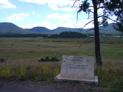
The Old Bushvalley Fort Marker
| 1 ► Arizona, Apache County, Alpine — The Old Bushvalley Fort — |
| On U.S. 180 at milepost 427.7, on the left when traveling west. | |||
| 2 ► Arizona, Cochise County, Benson — Four miles southeast at Council Rocks — Apache peace treaty with Cochise was ratified in 1872 — |
| Near Interstate 10 at milepost 320. | |||
| 3 ► Arizona, Cochise County, Bowie — Apache Pass - A Corridor Through Time — Fort Bowie National Historic Site — |
| On Apache Pass Road, 13 miles south of Business Interstate 10, on the left when traveling west. | |||
| 4 ► Arizona, Cochise County, Bowie — Bascom-Cochise Meeting Site — |
| Near Fort Bowie Trail, 0.6 miles Apache Pass Road. | |||
| 5 ► Arizona, Cochise County, Bowie — Cavalry Barracks — |
| Near Fort Bowie Trail, 1.5 miles south of Apache Pass Road. | |||
| 6 ► Arizona, Cochise County, Bowie — Centennial of Chiricahua Apache/U.S. Cessation of Hostilities 1886 — |
| On West Fifth Street, on the left when traveling west. | |||
| 7 ► Arizona, Cochise County, Bowie — Commanding Officer's Quarters — |
| Near Fort Bowie Trail, 1.5 miles south of Apache Pass Road. | |||
| 8 ► Arizona, Cochise County, Bowie — First Fort Bowie — |
| On Apache Pass Road. | |||
| 9 ► Arizona, Cochise County, Bowie — Fort Bowie — National Historic Site — |
| On South Apache Pass Road at Interstate 10 on South Apache Pass Road. | |||
| 10 ► Arizona, Cochise County, Bowie — Infantry Barracks — |
| Near Fort Bowie Trail, 1.5 miles south of Apache Pass Road. | |||
| 11 ► Arizona, Cochise County, Bowie — 086-352 — Old Fort Bowie — Guardian of Apache Pass — |
| On I-10 Extension (Interstate 10), on the left when traveling east. | |||
| 12 ► Arizona, Cochise County, Bowie — Post Cemetery — |
| Near Apache Pass Road, 2.3 miles south of Bear Springs Road. | |||
| 13 ► Arizona, Cochise County, Bowie — Post Trader — (Sutler's Store) — |
| Near Fort Bowie Trail, 1.5 miles south of Apache Pass Road. | |||
| 14 ► Arizona, Cochise County, Bowie — Second Fort Bowie — |
| Near Fort Bowie Trail, 1.5 miles south of Apache Pass Road. | |||
| 15 ► Arizona, Cochise County, Bowie — The Bascom Affair — |
| Near Apache Pass Road. | |||
| 16 ► Arizona, Cochise County, Bowie — The Battle of Apache Pass; July 15-16, 1862 — |
| Near Fort Bowie Trail, 1.1 miles Apache Pass Road. | |||
| 17 ► Arizona, Cochise County, Dragoon — Confederate Graves at Dragoon Springs — |
| 18 ► Arizona, Cochise County, Dragoon — Dragoon Springs Stage Stop — Land of Legends — Coronado National Forest — |
| On North Old Ranch Road. | |||
| 19 ► Arizona, Cochise County, Elfrida — Camp Rucker and the Indian Scouts — |
| On North Tex Canyon Road near East Rucker Canyon Road. | |||
| 20 ► Arizona, Cochise County, Elfrida — Camp Rucker Bakery and Commissary — |
| Near North Tex Canyon Road, 0.8 miles east of East Rucker Canyon Road. | |||
| 21 ► Arizona, Cochise County, Elfrida — Camp Rucker Timeline — |
| Near North Tex Canyon Road near East Rucker Canyon Road. | |||
| 22 ► Arizona, Cochise County, Elfrida — Chief Cochise — |
| Near Ironwood Road. | |||
| 23 ► Arizona, Cochise County, Elfrida — How Camp Rucker received its Name — |
| Near North Tex Canyon Road, 0.8 miles east of East Rucker Canyon Road. | |||
| 24 ► Arizona, Cochise County, San Simon — Geronimo Surrender Monument — |
| On Arizona Route 80 at milepost 406 near Skeleton Canyon Road, on the right when traveling east. | |||
| 25 ► Arizona, Cochise County, Sierra Vista — "Unknown Soldiers" — |
| 26 ► Arizona, Cochise County, Willcox — Erickson Family Cemetery — Sacred To the Memory of These Pioneers — |
| On Bonita Canyon Road, on the right when traveling east. | |||
| 27 ► Arizona, Cochise County, Willcox — 1 — The Schwertner House, 1880 — |
| On East Stewart Street south of North Haskell Avenue (Arizona Route 186), on the right when traveling east. | |||
| 28 ► Arizona, Coconino County, Happy Jack — Battle of Big Dry Wash — |
| On Rim Road (Forest Road 300), 12 miles east of Arizona Route 87, on the left when traveling east. | |||
| 29 ► Arizona, Coconino County, Happy Jack — General Crook Trail — |
| On Rim Road (Forest Road 300), 1.2 miles east of Arizona Route 87, on the left when traveling east. | |||
| 30 ► Arizona, Coconino County, Happy Jack — General Crook Trail — |
| On Rim Road (Forest Road 300), 8.4 miles east of Arizona Route 87, on the left when traveling east. | |||
| 31 ► Arizona, Gila County, Roosevelt — Al Sieber — |
| On The Apache Trail (Arizona Route 188 at milepost 245), on the right when traveling north. | |||
| 32 ► Arizona, Graham County, Fort Thomas — Geronimo — |
| On U.S. 70 at milepost 302, on the left when traveling east. | |||
| 33 ► Arizona, Graham County, Fort Thomas — Melvin Jones International Memorial — Historical Site — |
| On U.S. 70 at milepost 306, on the left when traveling east. | |||
| 34 ► Arizona, Graham County, Safford — Horatio Harris Merrill / Eliza Ann Merrill — |
| On U.S. 70 at milepost 364.7, on the left when traveling east. | |||
| 35 ► Arizona, La Paz County, Ehrenberg — In Memory of Hualapai Ancestors — Yu’ Nyihay Jamj Vo:jo — La Paz Trail of Tears - April 21, 1874 – April 21, 1875 — |
| On Poston Road/Mohave Drive (Arizona Route 1 at milepost 3), 6 miles north of Interstate 10, on the left when traveling north. | |||
| 36 ► Arizona, Maricopa County, Apache Junction — Alchesay — |
| On Arizona Route 88 at milepost 241, on the left when traveling east. | |||
| 37 ► Arizona, Maricopa County, Fort McDowell — Camp Reno — |
| On Beeline Highway (Arizona Route 87 at milepost 190) near North Fort McDowell Road, on the right when traveling north. | |||
| 38 ► Arizona, Maricopa County, Fort McDowell — Fort McDowell — |
| On Beeline Highway (Arizona Route 87) near North Fort McDowell Road, on the right when traveling north. | |||
| 39 ► Arizona, Mohave County, Bullhead City — Arizona Medal of Honor — |
| Near Rio Grande Road. | |||
| 40 ► Arizona, Mohave County, Kingman — Camp Beale Springs Arizona — |
| On Fort Beale Road at Wagon Trail Road, on the left when traveling north on Fort Beale Road. | |||
| 41 ► Arizona, Mohave County, Oatman — Olive Ann Oatman Fairchild — (1837-1903) — |
| On Main Street (Route 66) 0.1 miles east of Beacon Hill Road. | |||
| 42 ► Arizona, Navajo County, Fort Apache — Adjutant's Office (117) — |
| On General Crook Street, on the right when traveling east. | |||
| 43 ► Arizona, Navajo County, Fort Apache — Captain's Quarters (102 and 103) — |
| On General Crook Street, on the left when traveling east. | |||
| 44 ► Arizona, Navajo County, Fort Apache — First Commanding Officer's Quarters (101) — |
| On General Crook Street at Scout Street, on the left when traveling east on General Crook Street. | |||
| 45 ► Arizona, Navajo County, Fort Apache — Officer's Quarters (106) — |
| On General Crook Street, on the left when traveling east. | |||
| 46 ► Arizona, Navajo County, Fort Apache — Officers' Quarters (107, 108, 109) — |
| On General Crook Street, on the left when traveling east. | |||
| 47 ► Arizona, Navajo County, Fort Apache — Parade Ground — |
| On General Crook Street, on the right when traveling east. | |||
| 48 ► Arizona, Pima County, Tucson, Armory Park — Camp Lowell 1866-1873 — |
| On South 6th Avenue, on the right when traveling north. | |||
| 49 ► Arizona, Pima County, Tucson, Old Fort Lowell — Cavalry Barracks and Band Barracks — |
| Near North Craycroft Road. | |||
| 50 ► Arizona, Pima County, Tucson, Old Fort Lowell — Fort Lowell — |
| Near North Craycroft Road near East Glenn Street. | |||
| 51 ► Arizona, Pima County, Tucson, Old Fort Lowell — Fort Lowell — |
| On Craycroft Road, on the right when traveling north. | |||
| 52 ► Arizona, Pima County, Tucson, Old Fort Lowell — Fort Lowell — 1873 – 1891 — |
| Near North Craycroft Road. | |||
| 53 ► Arizona, Pima County, Tucson, Old Fort Lowell — Fort Lowell 1873-1891 / Post Hospital — |
| Near North Craycroft Road. | |||
| 54 ► Arizona, Pima County, Tucson, Old Fort Lowell — Headquarter's Buildings — |
| On North Craycroft Road, on the right when traveling north. | |||
| 55 ► Arizona, Pima County, Tucson, Old Fort Lowell — Infantry Barracks / Laundresses' Quarters — |
| Near North Craycroft Road. | |||
| 56 ► Arizona, Pima County, Tucson, Old Fort Lowell — Quartermaster Depot and Post Trader — |
| On North Craycroft Road, on the right when traveling north. | |||
| 57 ► Arizona, Pima County, Tucson, Old Fort Lowell — The Chief Trumpeter — Sculptor/Artist: Dan Bates — |
| On North Craycroft Road, on the right when traveling north. | |||
| 58 ► Arizona, Pima County, Tucson, Old Fort Lowell — Veterans Memorial — Fort Lowell Park — |
| Near North Craycroft Road. | |||
| 59 ► Arizona, Pinal County, Oracle — La Casa Del High Jinks — National Register of Historic Places — Historic Site — |
| Near South Highjinks Road, 0.7 miles north of Campo Bonito Road. | |||
| 60 ► Arizona, Pinal County, Sacaton — Honoring Native American Women Veterans — |
| On Sacaton Road (Arizona Route 87) at Casa Blanca Road, on the right when traveling east on Sacaton Road. | |||
| 61 ► Arizona, Pinal County, Superior — Picket Post Mountain — |
| On U.S. 60 at milepost 223, on the right when traveling east. | |||
| 62 ► Arizona, Santa Cruz County, Patagonia — John Ward's Ranch — |
| On Patagonia Highway (Arizona Route 82 at milepost 16), on the left when traveling west. | |||
| 63 ► Arizona, Santa Cruz County, Sonoita — Camp Crittenden — |
| On Arizona Route 82 at milepost 29.5, on the right when traveling west. | |||
| 64 ► Arizona, Yavapai County, Camp Verde — "0" Mile Post General Crook Trail — |
| Near East Hollamon Street, 0.3 miles North Montezuma Well Road (Arizona Route 260). | |||
| 65 ► Arizona, Yavapai County, Camp Verde — Camp Verde — |
| On General Crook Trail (South Access Road), 0.2 miles east of Interstate 17 Exit 285, on the right when traveling east. | |||
| 66 ► Arizona, Yavapai County, Camp Verde — Flagpole & Administration Building — Fort Verde, Arizona Territory — |
| Near E Hollamon Street when traveling north. | |||
| 67 ► Arizona, Yavapai County, Camp Verde — Fort Verde State Historic Park — The West As It Really Was! — |
| On Hollamon Street, on the right when traveling east. | |||
| 68 ► Arizona, Yavapai County, Camp Verde — Officers’ Row — Fort Verde, Arizona Territory — |
| On E Hollamon Street, on the right when traveling east. | |||
| 69 ► Arizona, Yavapai County, Camp Verde — Site of Married Officers' Quarters — Fort Verde, Arizona Territory — |
| Near E Hollamon Street when traveling north. | |||
| 70 ► Arizona, Yavapai County, Camp Verde — Site of Married Officers’ Quarters — Fort Verde, Arizona Territory — |
| Near E Hollamon St when traveling north. | |||
| 71 ► Arizona, Yavapai County, Camp Verde — Surgeon’s Quarters — |
| Near E Hollamon Street when traveling north. | |||
| 72 ► Arizona, Yavapai County, Camp Verde — The Congressional Medal of Honor - Apache Campaign 1872 - 1873 — |
| Near East Holloman Street, 0.2 miles north of Arizona Route 260. | |||
| 73 ► Arizona, Yavapai County, Camp Verde — Wales Arnold — |
| On South Main Street, on the right when traveling west. | |||
| 74 ► Arizona, Yavapai County, Prescott — John Towhey — |
| On Entrance to Bob Stump VA Medical Center, on the right. | |||