By Mark Hilton, October 18, 2015
Sunflower River Blues & Gospel Festival Marker (Rear)
| Near Blues Alley at Yahoo Avenue. |
| On Martin Luther King Boulevard at Harrison Avenue, on the right when traveling east on Martin Luther King Boulevard. |
| On Issaquena Avenue at Blues Alley, on the right when traveling south on Issaquena Avenue. |
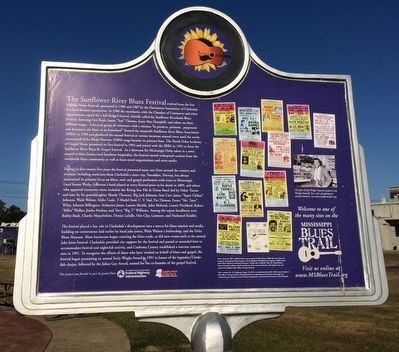
| On Issaquena Avenue at Blues Alley, on the right when traveling south on Issaquena Avenue. |
| On Delta Avenue, 0.1 miles south of East 2nd Street, on the right when traveling south. |
| On Commissary Circle at Hopson Road, on the left when traveling north on Commissary Circle. |
| On South Front Avenue at 2nd Street, on the left when traveling north on South Front Avenue. |
| On Oakhurst Stovall Road at Farrell-Eagles Nest West, on the right when traveling south on Oakhurst Stovall Road. |
| On West Railroad Avenue at West Georgetown Street, on the right when traveling south on West Railroad Avenue. |
| On Caldwell Drive (U.S. 51) at West Gallatin Street, on the left when traveling south on Caldwell Drive. |
| On South Ragsdale Avenue at West Gallatin Street, on the right when traveling north on South Ragsdale Avenue. |
| On School Drive at Administration Drive, on the right when traveling west on School Drive. |
| On Elm Street south of Southern Street, on the right when traveling south. |
| On West Oak Grove Road, 0.3 miles west of College Street, on the left when traveling west. |
| On U.S. 51 at Vinson Road, on the right when traveling south on U.S. 51. |
| On Center Street East south of Goodman Road (State Route 302), on the right when traveling south. Reported damaged. |
| On Pigeon Roost Road, 0.2 miles north of Camp Creek Blvd, on the left when traveling north. |
| Near Airways Boulevard north of Church Road West, on the left when traveling north. |
| Near Airways Blvd, 0.3 miles north of Church Road. |
| On Delta View Road, 0.4 miles south of Business U.S. 61, on the right when traveling south. |
| On Norfolk Road, 0.6 miles north of Old Mississippi Route 61, on the right when traveling north. |
| On Spencer Street at Milton Barnes Avenue, on the right when traveling north on Spencer Street. |
| Near East Memorial drive south of Smalling Drive, on the right when traveling north. |
| On East Sixth Street west of New Orleans Street, on the left when traveling west. |
| On East Sixth Street west of Mobile Street, on the right when traveling west. |
| On Mobile Street north of East Sixth Street, on the left when traveling north. |
| On Mobile Street north of East 5th Street, on the left when traveling north. |
| On West Pearl Street at Water Street, on the left when traveling west on West Pearl Street. |
| On 1st Street at Green Street, on the right when traveling east on 1st Street. |
| On Union Street, 0.2 miles west of Dr Martin Luther King Jr Boulevard (U.S. 51), on the right when traveling west. |
| On Union Street, 0.1 miles east of South Necaise Avenue, on the left when traveling east. |
| On Logtown/Possum Walk Trail, 1.5 miles west of State Highway 604, on the right when traveling west. |
| On South Beach Boulevard south of Brown Road, on the right when traveling south. |
| On Beach Boulevard (U.S. 90) at Porter Avenue, on the right when traveling east on Beach Boulevard. |
| On Main Street at Murray Street, on the right when traveling north on Main Street. |
| On U.S. 90 at Porter Avenue, on the right when traveling east on U.S. 90. |
| Near Beach Boulevard (U.S. 90) at Porter Avenue. |
| On Division Street at Elmer Street, on the right when traveling east on Division Street. |
| On Jones Park Drive, 0.2 miles east of 25th Avenue, on the right when traveling east. |
| On Southpark Drive, 0.1 miles south of Seaway Road, on the right when traveling south. |
| On 38th Avenue at 19th Street, on the right when traveling south on 38th Avenue. |
| On Martin Luther King Jr Boulevard at Arkansas Avenue, on the right when traveling east on Martin Luther King Jr Boulevard. |
| On East Beach Boulevard (U.S. 90) at Pratt Avenue, on the right when traveling east on East Beach Boulevard. |
| On Live Oak Avenue at Silver Lane, on the right when traveling north on Live Oak Avenue. |
| On Church Street west of Watkins Avenue, on the left when traveling west. |
| On 36th Avenue at 19th Street, on the right when traveling north on 36th Avenue. |
| On Rippy Road at Creosote Road, on the right when traveling east on Rippy Road. |
| On Three Rivers Road at Rippy Road, on the right when traveling north on Three Rivers Road. Reported missing. |
| On East Scenic Drive at Davis Avenue, on the right when traveling west on East Scenic Drive. |
| On Clarke Avenue north of West Railroad Street, on the left when traveling north. |
| On Handy Lane at Davis Avenue, on the right when traveling west on Handy Lane. |
| On Saucier Avenue at East Railroad Avenue, on the left when traveling north on Saucier Avenue. |
| On Sam Herring Road, 2.1 miles north of Natchez Trace Parkway, on the left when traveling north. |
| On Texas Street, 0.1 miles east of Church Street, on the right. |
| On West Leake Street at Jefferson Street, on the right when traveling west on West Leake Street. |
| On East Leake Street east of East Street, on the right when traveling east. |
| On Clinton-Tinnin Road at Northside Drive, on the right when traveling south on Clinton-Tinnin Road. |
| On East Leake Street east of East Street, on the right when traveling east. |
| On East College Street, 0.1 miles west of Fairmont Street, on the right when traveling west. |
| On West Northside Drive, 0.2 miles west of Vernon Road, on the left when traveling west. |
| Near Belmont Street at Vernon Road. |
| On Rose Street south of Dr. Robert Smith Sr Parkway, on the right when traveling south. |
| On Old Canton Road south of River Thames Road, on the right when traveling south. |
| On Parkway Avenue south of Utah Street, on the left when traveling south. |
| On Albermarle, 0.1 miles south of West Ridgeway Street. |
| On North State Street south of Mississippi Street, on the left when traveling north. |
| On John R. Lynch Street west of Short Street, on the right when traveling west. |
| On West Northside Drive, 0.5 miles east of Medgar Evers Boulevard, on the right when traveling east. |
| On Margaret W Alexander Drive east of Missouri Street, on the left when traveling east. |
| On West South Street at South Roach Street, on the right when traveling east on West South Street. |
| On North Gallatin Street at West Capitol Street, on the right when traveling north on North Gallatin Street. |
| On South Jefferson Street south of Morris Street, on the right when traveling south. |
| On East Capitol Street east of North Farish Street, on the right when traveling west. |
| On High Street, 0.1 miles east of North West Street, on the right when traveling east. |
| On North Lamar Street, on the left when traveling north. |
| Near East Fortification Street at North Jefferson Street. |
| On North Lamar Street at East Church Street, on the left when traveling north on North Lamar Street. |
| On Martin Luther King Jr Drive at Ann Banks Street, on the right when traveling south on Martin Luther King Jr Drive. |
| On North Lamar Street south of East Griffith Street, on the right when traveling south. |
| On North Farish Street at West Griffith Street, on the left when traveling north on North Farish Street. |
| On East Church Street east of Dreyfus Street, on the left when traveling east. |
| Near Bloom Street at Dr. Jessie Mosley Street. |
| On Farish Street at East Hamilton Street, on the left when traveling north on Farish Street. |
| On Farish Street at East Hamilton Street, on the left when traveling north on Farish Street. |
| On West Pearl Street, on the right when traveling east. |
| On West Pearl Street, on the right when traveling east. |
| Near Ayer Hall (East Side). |
| On John R. Lynch Street at Valley Street, on the right when traveling west on John R. Lynch Street. |
| On John R. Lynch Street at Short Hickory Street, in the median on John R. Lynch Street. |
| On John R. Lynch Street at Short Hickory Street, on the right when traveling east on John R. Lynch Street. |
| On Fortune Street, 0.1 miles east of Hattiesburg Street, on the right when traveling east. |
| Near Gibbs-Green Plaza, 0.1 miles west of Dalton Street, on the right when traveling west. |
| On John R. Lynch Street west of South Prentiss Street, on the right when traveling east. |
486 entries matched your criteria. Entries 101 through 200 are listed above.
⊲ Previous 100 —
Next 100 ⊳