On A82 just south of B8004, on the left when traveling north.
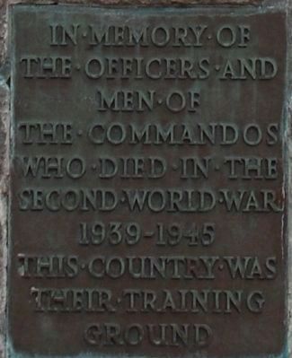
In the summer of 1940 when Britain's fortunes in World War II were at their lowest ebb and an enemy invasion was threatened Winston Churchill boldly ordered the raising of an elite force to raid the enemy-held coastline of Europe and regain the . . . — — Map (db m85790) WM
On Scotland Route A835 at Scotland Route A834, on the left when traveling south on State Route A835.
“Is e dia ar Tearmunn”
To the Glory of God & in Memory
of our Sons, our Brothers, and
Our Friends from this parish
who fell in the Great War —
1914 – 1919
Somerset Yeomanry —
Captain Robert Ernest . . . — — Map (db m127976) WM
On Scotland Route A836, 2.6 kilometers east of Scotland Route B855, on the right when traveling east.
Sacred to the Memory of
The Men of Dunnet, Who
Fell in the Great War
1914 — 1919.
Army
Sgt. Don. MacLeod, Seaforths · Sgt. Robt. Simpson, Amer. F.A. · L/Cl. Don. Manson, Seaforths · L/Cl. Wm. Robertson, Seaforths · Pte. Don. Banks, . . . — — Map (db m127612) WM
Near Aird Road, 4 kilometers north of Route A836, on the right when traveling north.
Erected in
Loving Memory
of
George William Mackay
Glaickbea
Son of
William and Christina Mackay,
Who Was Lost in the Titanic
Disaster, 15th April 1912
Aged 20 Years
“Blessed are the pure in heart
for they shall see . . . — — Map (db m128345) HM
On A836 at Unnamed Road, on the left when traveling west on A836.
To the Glory of God
And in Proud and
Loving Memory of
The Men of Reay
Who Fell in The
Great War
1914 — 1919.
Lieut. John S. Bain Canadian Royal Hdrs. · C.S.M. Thomas Dundas D.C.M. 7th Seaforth Hdrs. · Sergt. John cormack . . . — — Map (db m127825) HM
On Princes Street (Scotland Route B874) at Sir John’s Square, on the right when traveling north on Princes Street.
Sir George Sinclair
Baronet of Ulbster
Formerly M.P. for Caithness
Born 29th August 1790
Died 9th October 1868
This fountain was erected in 1894 by his only surviving son, (who while he lives will think of him every day) in grateful and . . . — — Map (db m127823) HM
On Sinclair Street (Scotland Route A9) at Sir George’s Street, on the left when traveling north on Sinclair Street.
The Rt Hon
John Sinclair
of Ulbster, Baronet
Born 10th May 1754
Died 21st Dec 1835
Formerly MP
for Caithness
( parts of the inscription are unreadable due to weathering )( side )
The American ambassador wrote in . . . — — Map (db m127822) HM
On Sinclair Street (Scotland Route A9) at Sir George’s Street, on the left when traveling north on Sinclair Street.
This Memorial
Is Dedicated To Those From
The Parish Of Thurso, Who,
In the War of 1914 — 1919
Laid Down Their Lives
For God and Country
and the Cause of Freedom
We Thank Our God Upon
Every Remembrance Of Them
Alexander . . . — — Map (db m127665) WM
Erected
In Loving Memory Of
The Men of Coigach
Who Fell In
The Great War
1914 — 1919.
Seaforth Hdrs.
L. Cpl. Murdo Campbell · L. Cpl. Murdo MacLeod · L. Cpl. Rodk. MacLeod · Pte. John MacLean · Pte. Donald Mackensie · Pte. . . . — — Map (db m122733) WM
On A835, 14.5 kilometers south of Scotland Route A837, on the right when traveling south.
Deep freeze mountains
Chan e fuar-bheann ach reothte
Picture the scene here 25,000 years ago … All you'd have seen was a great expanse of ice covering even the highest mountains and flowing far out to the west, beyond the Isle of Lewis. . . . — — Map (db m127969) HM
On Scotland Route A835 at A893, on the left when traveling south on State Route A835.
1914 – 1918
To
The Glory of God
and in Honoured Memory
of The Men of Ullapool
and surrounding District
who fell in the Great War
Dileas Guiseppe Bas
Kings R.R. Corps
Pte. Alexander MacRae
Loyal Scouts
Sgt. Murdo robertson . . . — — Map (db m127972) WM
On unnamed road, 2.9 kilometers east of Scotland Route A99, on the left when traveling east.
The lighthouse here at Duncansby Head is one of over 200 that are located around Scotland’s wild coastline. Operated and maintained by the Northern Lighthouse Board they warn ships of dangerous waters and provide safe passage.
Standing only . . . — — Map (db m122846) HM
On Main Street (Scotland Route A99) at High Street, on the left when traveling east on Main Street.
Keiss Quoad Sacra Parish
To the Memory of
The Fallen
In the Great War 1914 – 1919
Pte. Alexander Bain Sea.H. April 18, 1918. · Pte William Budge Can. I. Oct. 31, 1918 · Cpl. Donald Budge S.Gds. March 27, 1918. · Sea. William S. Bremner . . . — — Map (db m127544) WM
On Route A99, 15.6 kilometers north of the Wick River, on the left when traveling north.
Brochs: Beacons of Belonging
You are standing in one of the most important archaeological landscapes in Britain. Scan the horizon. You are surrounded by history: old harbours, houses and burials. As you move around the coastline you will . . . — — Map (db m127566) HM
Near Braes of Harrow, 1.6 kilometers north of Scotland Route A836, on the right when traveling east.
This Bench Has Been Placed
Here in Memory of
Her Majesty
Queen Elizabeth
The Queen Mother
By Her Majesty’s Friends
Trustees and Employees
At Mey
Queen Elizabeth Loved This
Castle Which She Saved From
Ruin in 1952, Spending Many . . . — — Map (db m127610) HM
Near Braes of Harrow, 1.6 kilometers north of Route A836, on the right when traveling east.
Repair and Conservation works to Castle of Mey: Queen Elizabeth Castle of Mey Trust
The Castle of Mey was the property of Queen Elizabeth The Queen Mother from 1952 until 1996, when Her Majesty generously gifted it with an endowment to the Queen . . . — — Map (db m127609) HM
On Scotland Route A99, 3.2 kilometers south of of the village of John o' Groats, on the right when traveling south.
For 5000 years people have settled in the land stretching before you, leaving signs of their burials in the chamibered cairns found on the island of Stroma and on the summit of Warth Hill that rises behind this point. It takes its name from the . . . — — Map (db m127567) HM
On Cliff Road at River Street, on the left when traveling east on Cliff Road.
In Honour of All
Those Who Suffered
And in Proud and Grateful
Remembrance of the Fallen
Sons of the Burgh of Wick
Who Died for Home
and Freedom
In the Great War, 1914 — 1919
Also
In Honoured and Grateful
Remembrance of All . . . — — Map (db m127542) WM
On Grant Street at Park Street, on the left when traveling west on Grant Street.
Erected by Public Subscription
To the Memory of
Benjamin Maclean, M.A., Divinity Student
Who Lost His Life on 26th August 1909, in
A Successful Effort to Rescue a Bather from
Drowning, off the East Beach, Burghead
“Greater Love . . . — — Map (db m128158) HM
On Grant Street at Park Street, on the left when traveling west on Grant Street.
Erected by the Inhabitants
Of Burghhead to the Memory
Of Their Fellow Townsmen
Whose Lives Were Sacrificed
In the Great War
1914 — 1919
That Both a Man Live For
To Serve His Fellows
To Honour His Country to Glorify God
And . . . — — Map (db m128157) WM
On Forteath Street at Bath Street, on the left when traveling west on Forteath Street.
The Harvest Reaper was a 45 foot long, Fyfie design fishing boat built of larch on oak at Wilson (Cockie) Noble's yard in Fraserburgh in 1931. She was powered by a Kelvin Recardo diesel engjine. She fished from Frasertburgh (the other Broch!) . . . — — Map (db m128159) HM
Near Scotland Route B9089 at Route B9011, on the left when traveling east.
Five Centuries in Kinloss
The Abbey Buildings
By the end of the 13th Century the majority of buildings in the Abbey Precinct would have been complete. The church lay on an east-west alignment with the main cloister to the south. To the east of . . . — — Map (db m128053) HM
On Scotland Route A96, 0.5 kilometers north of an unnamed road, on the left when traveling east.
The Pictish Rodney’s Stone was carved around 1,200 years ago.
A beacon for the community, it may have marked a place where people came to be baptised, married or hear Mass.
Brodie born and bred … The family home to over #400 varieties of . . . — — Map (db m128035) HM
Near Scotland Route B9089 at Scotland Route B9011, on the left when traveling west.
From Citeaux to Kinloss The Cistercian Family
Created in 1098 at Citeaux in France by twenty monks from the Abbey at Molesme, the Cistercian Order set out to adopt the exact observance of the Rule of St. Benedict. Changing their habits from the . . . — — Map (db m128050) HM
On Scotland Route B9011, 0.2 kilometers north of Fyrish Road, on the right when traveling north.
In Honoured Memory of
The Brave Men from Kinloss Parish
Who Fell in the Great War
1914 — 1919
Capt. C.G. Grant Peterkin, Scottish Horse. · Lieut. A.S. Middleton, R.A.F. · 2nd Lt. A. Masson, Seaforth Hrs. · Corpl. R.E. Bisset, Seaforth . . . — — Map (db m128037) WM
Near Scotland Route B9089 at Scotland Route B9011, on the left when traveling west.
The Cistercians of Kinloss
Cistercian monastic observance followed the Rule of St Benedict, insisting on plain clothing, two simple meals a day, and an austerity in church furnishings 'in places far from the concourse of men'. They developed an . . . — — Map (db m128073) HM
Near Station Road at Castle Road, on the left when traveling south.
Balvenie Castle was built in the 13th century as the mighty stronghold of one of Scotland's foremost barons, Alexander 'Black' Comyn, earl of Buchan (1244-89). It remained a noble residence for over four hundred years.
During that time, the . . . — — Map (db m128236) HM
On Conval Street at Church Street, on the left when traveling east on Conval Street.
The Clock In This Tower
Was by Public Subscription
Illuminated on
To Commemorate the Diamond Jubilee
Of Her Most Gracious Majesty
Queen Victoria
1837 — 1897
The Tower Clock Was Renovated in 1968
Following the Generous . . . — — Map (db m128260) HM
On Conval Street at Church Street, on the left when traveling east on Conval Street.
George Stephen
Lord Mount Stephen of Mount Stephen
British Columbia & Dufftown Banffshire
Banker and financier who in 1881 organized the Canadian Pacific Railway Company & became its first president. Instrumental in completing the . . . — — Map (db m128257) HM
On Church Road (Scotland Route A96) at Land Street, on the right when traveling east on Church Road.
6th Battn The Gordon Highlanders
Banffshire and Donside
To the Glory of God
and
In Memory of the Officers
Non Commissioned Officers and Men
Who Fell in the Great War
1914 — 1918
Also those who fell
In the Second Great War . . . — — Map (db m128234) WM
On Church Road (Scotland Route A96) at Land Street, on the right when traveling east on Church Road.
1914 — 1918
Sacred
To The Memory Of
The Men Of This Parish
Who Gave Their Lives
In The Great War
“Their Works Do
Follow Them”
( left alcove )
“Those we call the dead,
are breathers of an ampler
day . . . — — Map (db m128233) WM
On Balvenie Street (Scotland Route A941) at Coopers Mill, on the right when traveling north on Balvenie Street.
To the Memory of the Men
Of the Parish of Mortlach
Who Made the Supreme Sacrifice
In the Great War 1914 — 1919
Pte Cauld J. Seaforths · Pte Cauld W. Gordons · Pte George A. Gordons · Pte Glennie A. (M.M.) Blk. Watch · Pte . . . — — Map (db m128261) WM
Near Station Road at Castle Road, on the left when traveling south.
The Earl of Atholl’s Lodging
The Hall, about 1500.
The 4th earl of Atholl's new residence, built about 1550, was built on the palace plan, that is with a suite of rooms placed horizontally, as in the royal palaces of the Stewart kings at . . . — — Map (db m128238) HM
Near Station Road at Castle Road, on the left when traveling south.
The Kitchen Complex
Cooking
Communal feasting was very much a way of life in a medieval castle. As many of the earl's rents were paid in kind, not cash, food was in good supply. This kitchen complex provided food for the Hall and Chamber over . . . — — Map (db m128237) HM
Near Station Road at Castle Road, on the left when traveling south.
This Yew Tree was Planted on 13th August 2001
to Celebrate the 100th Birthday of
Janet Sheed Roberts
Granddaughter of William Grant — — Map (db m128239) HM
On Queen Street (Scotland Route B9040) at Kinneddar Street, on the right when traveling east on Queen Street.
James Square was laid out as an open space on land owned by Lt. Col. James Brander, Laird of Pitgaveny It was part of a large improvement plan in the 1830s - streets, houses and harbour - known as Branderburgh. This joined Seatown and Stotfield . . . — — Map (db m128161) HM
On Pitgaveny Street at Hill Street, on the right when traveling south on Pitgaveny Street.
To the Memory of the Men of Lossiemouth
And the Landward Part of the Parish of Drainie Who Died in the
Service of their Country during the War 1914 — 1919 — Not in Vain
Seaforth Highlanders
Capt. Edwards G.E. D.S.O. · Capt. . . . — — Map (db m128162) WM
On Queen Street (Scotland Route B9040) at Kinneddar Street, on the right when traveling east on Queen Street.
David West Raymond (1868 – 1936) is best known for his local Moray seascapes and landscapes in watercolour.
James Ramsay MacDonald was born in poverty in Lossiemouth in 1866. He became Britain’s first Socialist Prime Minister in 1924 and . . . — — Map (db m128160) HM
On Pitgaveny Street at Commerce Street, on the left when traveling north on Pitgaveny Street.
Recovered from the Moray
Firth between Covesea and
Tablet Ness on or about
The year 1882 by the fishing
Smack “Isabella & Janes” INS 2868
Wm. Reid (BO) Skipper
Lossiemouth — — Map (db m128075) HM
Antonine Scotland
The Antonine period 140-c.165. Until c.139 AD Hadrian's Wall marked the limit of Roman occupied Britain; but when Antoninus Pius became Emperor he ordered the army to push further north and to build a second wall, this . . . — — Map (db m88540) HM
On Dundas Street at Graham Place, on the left when traveling south on Dundas Street.
Alexander Graham led
local merchants to oppose
their tax liability to the
Royal Burgh of Kirkwall.
Stromness became an
independent burgh
as a result. — — Map (db m127615) HM
On Ferry Road at Victoria Street, on the right when traveling south on Ferry Road.
Alexander Graham
Died 16th April 1783
This fountain is erected to perpetuate the memory of Alexander Graham, a native of this town, who, during the years 1743 - 1758, at great pecuniary sacrifice to himself, fought the Royal Burgh of Kirkwall, as . . . — — Map (db m127658) HM
On Ferry Road at Victoria Street, on the right when traveling south on Ferry Road.
Dr John Rae was born in Orkney at the Hall of Clestrain. He became an explorer with the Hudson’s bay Company, learning from the native people how Timothy survive in the Canadian Arctic. He led three of the four expeditions in which he took part, . . . — — Map (db m127613) HM
On Dundas Street at Khyber Pass, on the left when traveling south on Dundas Street.
Home of
Eliza Fraser
Who in 1836 survived shipwreck
on the Great Barrier Reef and
capture by Aborigines to
become a legendary
figure in Australian
history. — — Map (db m127651) HM
On Victoria Street at Graham Place, on the right when traveling south on Victoria Street.
Fitzroy Fisheries Barometer
Vice Admiral Robert Fitzroy RN
(5 July 1805 — 20 April 1865)
In 1857 Admiral Robert Fitzroy, designed the robust and simple 'Fishery Barometer' and devised a system whereby such instruments would be placed . . . — — Map (db m127614) HM
On S End at Mayburn Court, on the right when traveling south on S End.
Login’s Well
There Watered Here
The Hudson’s Bay Coy’s Ships
1670 – 1891
Capt. Cook’s Vessels
Resolution and Discovery
1780
Sir John Franklin’s Ships
Erebus and Terror
On Arctic Exploration
1845
Also the Merchant Vessels . . . — — Map (db m127623) HM
Maes Howe has been inscribed upon the World Heritage List of the Convention concerning the Protection of the World Cultural and Natural Heritage. Inscription on this List confirms the exceptional universal value of a cultural or natural site which . . . — — Map (db m76868) HM
On S End at Rae’s Close, on the right when traveling south on S End.
Rae’s Close
The Orcadian Arctic Explorer
Dr. John Rae, in 1854, discovered
Rae Strait (the last link in
the Northwest Passage) and
the tragic fate of the
Franklin Expedition — — Map (db m127620) HM
On Ferry Road at Victoria Street, on the left when traveling south on Ferry Road.
Shipwrecks of Scapa Flow
Scuttle!
On 21 June 1919 the entire German High Seas Fleet of 74 warships was scuttled in the great natural harbour of Scapa Flow in the Orkney Isles on the orders of Rear Admiral Ludwig von Reuter. The sinking . . . — — Map (db m127661) HM
On Ferry Road at Victoria Street, on the right when traveling south on Ferry Road.
( panel 1 )
Violet, Dorothy and Kathleen ON-1236 (17-16)
Severn class lifeboat
The Severn class all-weather lifeboat is the largest in the RNU fleet. Severn class lifeboats are allocated to stations where they can lie afloat . . . — — Map (db m127565) HM
On N End Road at Hillside Road, on the left when traveling north on N End Road.
In Memory Of
The Gallant Dead Who
Gave Their Lives For
Honour and Freedom
In The European War
1914 — 1919 bnn
Erected
by The Inhabitants of
the Town and Parish
of Stromness
Assisted by Natives of
the District in This
and . . . — — Map (db m127656) WM
On S End, 0.3 kilometers south of Hellinhole Road, on the left when traveling south.
The Cannon
Reputed to have been salvaged from
the American privateer ‘Liberty’ in
1813. It was used to fire a
salute to the Hudson’s
Bay Company ships. — — Map (db m122732) HM
On John Street at Ferry Road, on the right when traveling north on John Street.
The Lieutenant’s House
This house was built by Lieutenant
James Robertson RN, who
commanded HMS Beresford at
The Battle of Plattsburg
in 1812. — — Map (db m127653) HM
The Fortingall Yew
Rooted in History
Before you stands Europe's- and possibly even the world's - oldest living thing. Under the dark veil of needles are two relic trunks of a huge, ancient yew tree. Scholars believe the roots of this great . . . — — Map (db m86642) HM
This granite monument was erected in 1912 through the efforts of the London Renfrewshire Society. The column is carved from a single piece of stone. The architects were John C T Murray and J Andrew Minty. The panels illustrating important events in . . . — — Map (db m86407) HM
The Yew Tree
This tree is known locally as the Wallace Yew. It is thought to be 300 years old. It has been surveyed and a programme of treatment is under way to improve its health.
The Wallace Oak
An ancient oak which stood by . . . — — Map (db m86456) HM
On Wallace Avenue just south of Park Avenue, on the right when traveling north.
Wallace was a hero of Scotland's Wars of Independence against England during the 13th and 14th centuries.
Recent archaeological work on this site proves that during the 13th/14th centuries there was a significant fortified structure here . . . — — Map (db m86406) HM
On Main Road at Castle Street, on the right when traveling east on Main Road.
Welcome to the traditional site of William Wallace's birthplace.
Wallace was a hero of Scotland's Wars of Independence against England during the 13th and 14th centuries.
Recent archaeological work on this site proves that during the . . . — — Map (db m85741) HM
An eccentric vision
Along this path a dramatic statue of William Wallace gazes out across the Tweed. This is just one of a number of features in the area built by David Stuart Erskine, the 11th Earl of Buchan: if you continue down the . . . — — Map (db m85740) HM
For centuries, Melrose Abbey was connected to the Scottish Crown. While it never gained the regal position of Iona or Dunfermline, its location close to England and association with kings has given it a special place in Scottish history.
David . . . — — Map (db m88486) HM
Sir Walter Scott loved the Borders landscape, history and people with a passion. He was the most popular writer of his age: when he died his funeral procession was over a mile long. It took his body from his home at Abbotsford to his tomb in . . . — — Map (db m88925) HM
This monument, embodying the spirit of the Selkirk tradition and erected to commemorate the four hundredth anniversary of the Battle of Flodden Field, was unveiled by the Earl of Roseberry, K.G., KT.
Andrew Lusk Allan Provost
1913 — — Map (db m85662) HM
The tower, designed by the builder and Mason Robert Snodgrass, was erected in 1855 by one William Patrick of Roughwood. It was in tribute to William Wallace "Guardian of Scotland." It is one of series of Wallace monuments built throughout the . . . — — Map (db m85831) HM
Crossraguel Abbey was founded by Earl Duncan of Carrick (died 1250) and colonised by monks from the Cluniac abbey at Paisley. The lands bestowed on it lay almost entirely in Carrick, and included fishing rights, coal deposits and the churches of . . . — — Map (db m88989) HM
Known locally as 'Croy Brae'
This runs the quarter mile from the bend overlooking Croy Railway Viaduct in the west (286 feet above ordnance Datum) to the wooded Craigencroy Glen (303 feet A.O.D.) to the east.
Whilst there is this slope of . . . — — Map (db m88538) HM
Torn apart by the Wars of Independence, this stalwart castle survived siege after siege. Rebuilt, it became an imposing noble and royal stronghold.
Castle Highlights
1. Donjon, William Murray's grand residence.
2. Prison tower with a . . . — — Map (db m88028) HM
On this mound, site of an ancient Roman fortification, stood the Royal Castle of Lanark, a residence of David I (1124-1153), William the Lion (1165-1214), and later kings from which many of their royal charters are dated. It was the meeting place of . . . — — Map (db m85668) HM
This plaque marks the site of the house reputed to be the marital home of Sir William Wallace and Marion Braidfute.
It was at Lanark in 1297 that Wallace first drew sword to free his native land. He was captured and cruelly executed at . . . — — Map (db m85666) HM
This mighty fortress was a powerful statement of the Duke of Albany's status as governor of the Scottish Kingdom.
Strong and defensible yet with luxurious accommodation, Doune was every bit the royal residence. Albany ruled on behalf of . . . — — Map (db m91376) HM
Defeat at the castle seems to have utterly disheartened King Arthur ... The ferocity of the French taunting took him completely by surprise and Arthur became convinced that a new strategy was required if the quest for the Holy Grail were to be . . . — — Map (db m82100) HM
"For God and St. Andrew"
Robert the Bruce
King of Scots
Planted his standard
near this spot
when the
Scottish Patriots
under the command
vanquished the Army of
Edward II of England at
the Battle of
Bannockburn
24th . . . — — Map (db m85598) HM
The National Wallace Monument was opened in 1869 to celbrate Scotland's national hero Sir William Wallace. It was here, with Sir Andrew Moray, that he rallied his band of fighters on the 11th Septemeber 1297, and fought and defeated at the Battle of . . . — — Map (db m85595) HM WM
In early September 1297 a mighty army arrived in Stirling to put down Scots resistance to English rule. The Scots allowed around half the invaders to advance across the narrow bridge over the Forth. Then William Wallace and the Scots swept forward . . . — — Map (db m85596) HM
Over the past 1,500 years the rock has served as the centre of the British kingdom of Strathclyde, a medieval frontier post, and on occasion, a royal residence.
Following the 1715 Jacobite Rising it became a garrison fortress, its impressive . . . — — Map (db m88031) HM
English
The west range, the plainest of the four fronts of the palace, was completed about 1504 in the reign of James IV. The row of large rectangular windows at the first floor level represent a suite of royal rooms: from left to right, . . . — — Map (db m86250) HM
286 entries matched your criteria. Entries 201 through 286 are listed above. ⊲ Previous 100