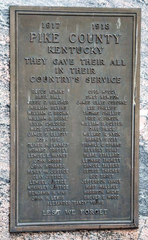
1917–1918. They gave their all in their country’s service. Rufus Adkins • Basil Ball • Jesse D. Belcher • William Bevins • William C. Brown • William B. Burke • Ervin Childers • Wade Cummings • James S. Elliott • Josh Fife • Oliver H. . . . — — Map (db m146149) WM
On Hambley Boulevard (Business U.S. 460) at Huffman Avenue, on the left when traveling north on Hambley Boulevard.
Established by the Presbyterian
Church in 1889 for the education
of youth from the mountains of
Southern Appalachia. It now draws
students from many states and
foreign lands. The Celtic Cross,
visible from many points of wide
area, symbolizes . . . — — Map (db m146167) HM
On Huffman Avenue east of Main Street, on the right when traveling east.
John Paul Riddle
Riddle was born May of 1901 to two teachers, Tandy and Bessie Riddle. His mother passed in 1903, and he spent at least some time living with his paternal grandmother on Shelby Creek. It's said that he dreamed of flying even . . . — — Map (db m306441) HM
On East Shelbiana Road (U.S. 460) 0.9 miles east of Chloe Road (Kentucky Route 1460), on the right when traveling east.
Kentucky legislature established
Pike County Dec. 19, 1821. First
county seat was located near here
on the Peyton Justice farm and
named Liberty. No courthouse was
built here due to opposition to
site. On Dec. 24, 1823, new county
seat . . . — — Map (db m146229) HM
On Flippin Lamb Road (Route 249), on the right when traveling north.
The proprietary town of "Pikesville" was established here with 10 streets and public square in August, 1818, east of Pikesville Branch and north of "Old Pikeville Rd" on 75 acres of land granted to Thomas Flippin in 1798. Pikesville was narrowly . . . — — Map (db m276682) HM
On Main Street north of Pike Street, on the left when traveling north.
Born in Parkersburg. WV, in 1818
Dils came to Pikeville circa 1840
and became a merchant. In Oct.
1861, while the area was under
Confederate control, he was arrested
for Union sympathies. Sent to Libby
Prison in Richmond, VA, he was
quickly . . . — — Map (db m146142) HM
On Kentucky Route 292 at Lower Stringtown Road, on the right when traveling south on Kentucky Route 292.
Sally McCoy. Sarah Elizabeth (Sally) McCoy was the daughter of Rosanna McCoy and Johnse Hatfield. Her parents’ love affair played a role in the infamous Hatfield-McCoy feud. Although circumstances prohibited the two from marrying, the child . . . — — Map (db m146141) HM
On Bob Amos Drive at Cedar Creek Road ( Route 1384), on the left when traveling south on Bob Amos Drive.
Welcome to Pike County, Kentucky, home of Patty Loveless.
US 23 was named “The Country Music Highway” in 1994 in recognition of the numerous country music stars from the region. In 2002 through the efforts of Congressman Harold “Hal” Rogers and . . . — — Map (db m212048) HM
On 15th Street at Front Street, on the left when traveling north on 15th Street.
Welcome to Boyd County, Kentucky, home of the Judds (the famous mother/daughter Nashville award winning duo). US 23 was named "The Country Music Highway" in 1994 in recognition of the numerous country music stars from the region. In 2002, through . . . — — Map (db m228072) HM
On U.S. 23/460 at Mare Creek, on the right when traveling south on U.S. 23/460.
In 1845, Ky. Legislature put Mare Creek farm of Tandy R. Stratton in Floyd County. In Pike since it was formed from Floyd, 1821. Strip separates farm area from Floyd, forming "island" in Pike. Reported to be the only instance in U.S. His grandfather . . . — — Map (db m170890) HM
Near Huffman Avenue at Main Street, on the right when traveling east. Reported unreadable.
In December 1861, Col. James A. Garfield, 42nd Ohio Infantry, was selected by General Don Carlos Buell to take a force to the Big Sandy Valley of Kentucky to clean the region of the Rebels. The previous month, Union General William “Bull” Nelson had . . . — — Map (db m146170) HM
On Collins Highway (Kentucky Route 122) 2.1 miles south of U.S. 460, on the left when traveling south.
Born in Lancaster, Pa. to immigrant German parents. Joined 4th Virginia Infantry in fall of 1776. Saw George Washington’s retreat across the Hudson in Nov. Served until 1779. Married Sarah Phillips in 1780. Settled in Shelby Valley in 1800. Sarah . . . — — Map (db m146230) HM
Near Jerry West Highway (West Virginia Route 44) 0.5 miles south of Philips Street, on the right when traveling south.
The Tug Fork River is 159 miles long, with approximately 90 of those miles running along West Virginia's southwest border with Kentucky. Because of its rough terrain and steep hills, Tug Valley was one of the last places to have settlements in . . . — — Map (db m306417) HM
On Warm Hollow Road at Magnolia Avenue ( Route 49), on the right when traveling north on Warm Hollow Road.
With roots extending back years, this famous family feud erupted fully after an 1882 election day brawl in Pike County, Kentucky, between 3 sons of Randolph McCoy and Ellison Hatfield, brother of "Devil Anse.” After Ellison died, the McCoys were . . . — — Map (db m164955) HM
On Pigeon Roost Road (Kentucky Route 1714) 1.4 miles north of Caney Fork Road (County Route 1114), on the left when traveling north.
Colorful frontiersman. An ancient
headstone at grave shows he was
born 1735, died 1855. Enlisted for
three short periods in Revolution
and fought Indians and Tories in
west Carolinas and east Tennessee.
Legend tells that he was captured
by . . . — — Map (db m146107) HM
On Kentucky Route 319 0.7 miles west of Right Turkey Toe Branch, on the left when traveling west.
HARDY, Ky. - What do you get when you combine clear, fresh well water from the original McCoy family log
cabin site with Pauley Hollow Distillery? Real Appalachian moonshine made in Pike County, Kentucky.
The old rustic water well of Randal . . . — — Map (db m162517) HM
On Lower Stringtown Road at Route 292, on the right when traveling west on Lower Stringtown Road.
Sarah Elizabeth, “Little Sally,” was the daughter of Roseanna
McCoy and Johnse Hatfield. She was born in the spring of
1881 and died when she was only eight months old. In 1880,
Roseanna met Johnse at an Election Day celebration . . . — — Map (db m146138) HM
Near Lower Stringtown Road at Route 292, on the right when traveling west.
Sarah Elizabeth, “Little Sally,” was the daughter of Roseanna
McCoy and Johnse Hatfield. She was born in the spring of
1881 and died when she was only eight months old. In 1880,
Roseanna met Johnse at an Election Day celebration on
Blackberry . . . — — Map (db m146139) HM
Near Jerry West Highway (West Virginia Route 44) 0.5 miles south of Philips Street, on the right when traveling south.
Descended from English settlers, the Hatfield clan made its way to western Virginia by the 1770s. The first Hatfield to arrive at Tug Fork Valley was Ephraim, nicknamed "Eph-of-All", from Russell County, Virginia. He and his second wife, Anna . . . — — Map (db m306427) HM
Near Huffman Avenue at Main Street, on the right when traveling east.
Here Col. Garfield was commissioned Brigadier General in the Union army. The man who later became president was sworn in as general by Squire Charles of Pike County January 1862. — — Map (db m146169) HM
On Hambley Boulevard (Business U.S. 460) at Huffman Avenue, on the right when traveling south on Hambley Boulevard.
Businessman
Pike County Judge Executive
Governor of Kentucky
President of the University of Pikesville
Learn as though you were to live forever
Live as though you were to die tomorrow — — Map (db m307456) HM
On West Washington Street (U.S. 54) at Madison Street, on the right when traveling west on West Washington Street.
Abraham Lincoln was a frequent visitor to Pike County.
He left his judicial circuit and crossed the Illinois River to practice law with many of Pike County's leading attorneys, forming close associations with prominent Whig and . . . — — Map (db m68918) HM
March 4, 1980: Phase II underway at a cost of $22.2
million. Included relocation of railroad and downtown
coal tipples, construction of a bridge across the cut,
moving five million cubic yards of dirt to build the
roadway base, diversion of . . . — — Map (db m273309) HM
On West Main Street at North Main Cross Street when traveling west on West Main Street.
This is a two sided markerSide A:
Bowling Green, the capital of Pike County, lies 12 miles in from the Mississippi River on a rolling plain, 880 feet above sea level. First pioneer here, John W. Basye, came in 1820 and by 1823, . . . — — Map (db m78676) HM
On Olive Street at Cardinal Avenue, on the right when traveling east on Olive Street.
The structure that once occupied this place was the home of United States Senator John Brooks Henderson and his wife Mary Foote Henderson, two people who made their marks on the history of the nation. John Henderson was born in Virginia in 1824, . . . — — Map (db m159508) HM
Near Chloe Road (Kentucky Route 1460) east of South Bypass Road (Route 1460), on the left when traveling east.
The Dils Cemetery is believed to be the first integrated cemetery in Eastern Kentucky. Colonel John Dils, who was opposed to slavery, gave many freed slaves jobs in his tannery and general store. He later provided gravesites for them and their . . . — — Map (db m146196) HM
Thin black lines indicate changes in relevance. Between each pair of lines entries are ordered geographically but all have the same relevance.
* Inflectional forms of words are their plurals, singulars, and possessives as well as gramatical tenses and similar variations.