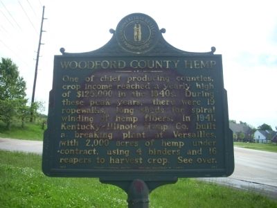
On Lexington Road (U.S. 60) at Paynes Mill Road, on the right when traveling west on Lexington Road.
Side One
Hemp in Kentucky:
First crop grown 1775. From 1840 to 1860, Ky. Production largest in U.S. Peak in 1850 was 40,000 tons, value of $5,000,000. Scores of factories made twine, rope, gunny sacks, bags for cotton picking and . . . — — Map (db m31133) HM
Near Ford Road/4 Mile Road (Kentucky Route 1924) 1.2 miles south of Boonesboro Road ( Route 627), on the left when traveling south.
Directly in front of you is a fragment of the original road built to take men and supplies from the road below, now KY 1924, to the earthwork. This road is now a foot trail, but many of Clark County's original roads are still in use. As the maps . . . — — Map (db m74728) HM
On North Main Street (State Highway 71) at Greenville Street (State Highway 20) on North Main Street.
Burt-Stark House When Jefferson Davis, President of the Confederacy, left Richmond after its fall in April 1865, he traveled south, trying to reach and rally the remnants of his army. On May 2, he spent the night at the home of Col. Armistead . . . — — Map (db m10564) HM
On Main Street at Greenville Street, in the median on Main Street.
This tablet was placed here to commemorate the last meeting of the Confederate States Cabinet which was held in the Burt House near by directly in front of this stone.
The following cabinet members were present:
Jefferson Davis, President . . . — — Map (db m73949) HM
Near East Main Street (U.S. 60) at Midland Avenue (U.S. 60), on the right when traveling west.
Robert A. Alexander established the 2,000-acre Woodburn Stud in Woodford County, in part with the inheritance left by an uncle in Scotland. By creating a commercial breeding operation, Alexander introduced a degree of professionalist to breeding . . . — — Map (db m58340) HM
Near East Main Street (U.S. 60) at Midland Avenue (U.S. 60), on the right when traveling west.
To the general public, the identity of William S. Farish is likely created by his term as the United States Ambassador to England, his business association and friendships with both Presidents Bush, and his friendship with Queen Elizabeth II, who . . . — — Map (db m285053) HM
known as Abe, was born in Midway, Woodford County. He began his career as a Thoroughbred
trainer for Abraham Buford, Bosque Bonita Far, Woodford County where he trained McWhitter (1876-1878). Perry became assistant trainer for Leonard W. Jerome, . . . — — Map (db m169792) HM
On Broadway Street (U.S. 25) at W. Court Street, on the right when traveling north on Broadway Street.
Formed out of a part of Woodford County, it was the second created after Kentucky became a state.
Named for Gen. Charles Scott, 1739-1813, a Va. native. Officer in Revolution, saw service at Trenton, 1776, Germantown and Monmouth, 1777, . . . — — Map (db m70537) HM
The only father-son generals in the Civil War, except for Robert E. Lee and his son, are buried 1 block south. Gen. Jerome B. Robertson, Commander of Hood's Texas Brigade, Nov. 1862 to Jan. 1864, died in Waco Jan. 7, 1890. His son, Gen. Felix H. . . . — — Map (db m178186) HM
Dr. Luke P. Blackburn Correctional Complex
Originally Kentucky Village, this complex renamed in honor of Dr. Luke P. Blackburn, 26th Governor of Ky., in recognition of his pioneer efforts in prison reform. Elected Governor in 1879, after . . . — — Map (db m170039) HM
On Capital Avenue at West Todd Street, on the right when traveling south on Capital Avenue.
(side 1)
After Kentucky became a state, five commissioners were appointed on June 20, 1792, to choose a location for the state capital. They were John Allen and John Edwards (both from Bourbon Co.), Henry Lee (Mason Co.), Thomas Kennedy . . . — — Map (db m62249) HM
On South Main Street (Kentucky Route 33) at Macey Ave, on the left when traveling south on South Main Street.
Josephine Kirby Williamson Henry, a vocal advocate for Kentucky women in the 1880's and 1890's, was born in Newport and spent her adult life in Versailles. She worked in the Kentucky Equal Rights Association and National Women's Suffrage Association . . . — — Map (db m262962) HM
On Old Frankfort Pike at Alexandria Drive, on the right when traveling east on Old Frankfort Pike.
Toll Roads, toll houses, stage stations and taverns. Railroad Stations with shipping docks, post offices and dry-goods stores.
Towns invented by the railroad and small communities congregated at crossroads and mills.
Since 1800, . . . — — Map (db m194569) HM
On Wilkinson Boulevard, on the right when traveling south.
Between 1776 and 1780 Kentucky was a single county of the
commonwealth of Virginia. In 1780 the Virginia legislature divided
Kentucky County into three smaller counties–Fayette, Jefferson
and Lincoln. These became Kentucky's first three counties . . . — — Map (db m194233) HM
On West Chestnut Street east of South 10th Street, on the right when traveling east.
Dr. James Bond (1863-1929)
Born in Woodford County during slavery, James Bond was raised in Knox Co. He led a young steer to Berea College for his tuition. In 1896, became a trustee of Berea. After Day Law passed, he joined college's staff . . . — — Map (db m161254) HM
On Delaware Bend Road south of U.S. 24, on the left when traveling south.
Tale of Ensign James Liggett
After American militia troops forcibly ended the 1812 siege of Fort Wayne, General James Winchester's Army of the Northwest marched down the north side of the Miami (Maumee) River to stop or retard advancing . . . — — Map (db m265378) HM
Near College View Avenue north of Rose Street when traveling north.
Adamstown
This interurban African-American community
was established in 1872 when working class
and skilled laborers began purchasing land
from George M. Adams to build homes.
Adams, a native of Barbourville, Kentucky,
was a slave owner . . . — — Map (db m169874) HM
On Old Frankfort Pike at Alexandria Drive, on the right when traveling east on Old Frankfort Pike.
You stand at Lexington's urban growth boundary.
Alexandria Drive - here at the intersection of Old Frankfort
Pike - sets the edge of commercial land use and protects land
to the west from non-agricultural development.
Lexington's . . . — — Map (db m194576) HM
On Old Frankfort Pike (Route 1681) at Alexandria Drive, on the right when traveling east on Old Frankfort Pike.
The early explorers and surveyors recognized unusually good soil
by its appearance, physical qualities and vegetation
- even if they didn't comprehend the geology beneath.
This 2,400 square mile area -
the Inner Bluegrass region of . . . — — Map (db m194469) HM
On South Main Street at Macey Avenue, on the right when traveling south on South Main Street.
Woodford County, 1789
Last of nine formed by Virginia
before Kentucky became a state
in 1792. Original county taken
from Fayette and extended as far
north as the Ohio River; included
the area of 7 present counties
and parts of 4 . . . — — Map (db m170007) HM
Near State Highway 92 Spur 0.3 miles west of State Highway 77.
On February 11, 1843, Captain Ewen Cameron led Texan prisoners from the Dawson and Mier expeditions in an escape from Hacienda Salado, 80 miles south of Saltillo, Coahuila. Dr. Richard Fox Brenham died attempting escape, one of five Texans killed. . . . — — Map (db m201814) HM
On North 8th Street (Business U.S. 45) at North H C Mathis Drive (U.S. 45), on the right when traveling east on North 8th Street.
Paducah, Kentucky
McCracken county seat, founded by Gen. William Clark of Lewis and Clark Expedition at confluence of Ohio and Tennessee Rivers. Named for legendary Indian Chief Paduke. Home of Vice Pres. Alben Barkley and birthplace of Irvin . . . — — Map (db m146587) HM
On Poplar Level Road (State Road 864) 0.1 miles south of Eastern Parkway, on the right when traveling north.
Louisville Cemetery
Original 31 acres incorporated Mar. 23, 1886, by prominent black citizens Bishop W. H. Miles, H. C. Weeden, J. Meriwether, A. J. Bibb, W. P. Churchill, William H. Gibson, Sr., and Felix Johnson. Buried here are Dr. Robert . . . — — Map (db m161299) HM
On Irvin Cobb Drive 0.1 miles east of Bethel Street, on the right when traveling west.
Paducah, Kentucky. McCracken county seat, founded by
Gen. William Clark of Lewis and
Clark Expedition at confluence of
Ohio and Tennessee Rivers. Named
for legendary Indian Chief Paduke.
Home of Vice Pres. Alben Barkley
and birthplace . . . — — Map (db m170135) HM
On South Main Street at Macey Avenue, on the right when traveling south on South Main Street.
Randall Lee Gibson
Confederate brig. gen. Born in
Woodford home of his grandfather.
Parents lived Louisiana. Graduate
Yale Univ., 1853. Distinguished
for leadership at Shiloh, in 1862
Kentucky campaign, Chickamauga,
Atlanta and Hood's . . . — — Map (db m170008) HM
He is ranked among the representative citizens of Los Angeles County. He left Missouri in 1849 and settled in Santa Clara County. He came to Southern California in 1869 and purchased 325 acres of the old Dalton Tract, near El Monte. His family . . . — — Map (db m152637) HM
On Wilkinson Boulevard, on the right when traveling south.
This is an example of a farm
entryway, a type that has become
prevalent in the Bluegrass region.
Currently masons are asked to
build new entrances at farms and
estates, and this adds to the work
they do in private gardens and on
fence . . . — — Map (db m194223) HM
On Weisenberger Mill Road 0.2 miles east of Sexton Way, on the right when traveling east.
has been placed on the
National Register
of Historic Places
by the United States
Department of the Interior
for its
architectural significance. — — Map (db m202969) HM
Thin black lines indicate changes in relevance. Between each pair of lines entries are ordered geographically but all have the same relevance.
* Inflectional forms of words are their plurals, singulars, and possessives as well as gramatical tenses and similar variations.