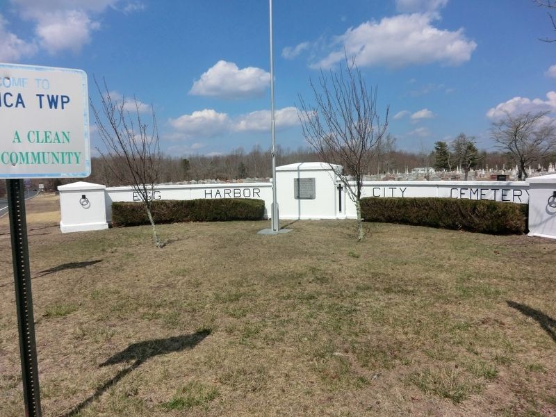
On Moss Mill Road at Hamburg Avenue on Moss Mill Road.
On this 50th anniversary of the American Legion, we dedicate this plaque to the memory of all veterans who lie here in peace.
Rudolph Elmer Post #158 March 15, 1969. — — Map (db m108256) WM
Welcome to the site of Dr. Smith’ Neutral Water Sanitarium. Before you is the focal point of the sanitarium, the flowing cedar waters in the serpentine creek. The site before you and behind you was the destination of hundreds of people from the . . . — — Map (db m64260) HM
Near Atlantic City Expressway 7.5 miles east of 12th Street (New Jersey Route 54), in the median.
This section of steel floor truss was recovered from "Ground Zero" of the World Trade Center. May it serve as a reminder of the events and ultimate sacrifices made September 11, 2001 — — Map (db m208364) WM
Near Atlantic City Expressway 7.5 miles east of New Jersey Route 54, in the median.
(Quercus Alba) White Oak has a very distinctive light ashy gray bark. It occurs in a wide variety of habitats and grows very slowly. Trees 300 years old are not uncommon, and some have been known to live 600 years. It's uses are many, . . . — — Map (db m208366) HM
On Atlantic City Expressway 7.6 miles east of 12th Street (New Jersey Route 54), in the median.
The original World Trade Center in March 2001. The tower on the left with antenna spire was 1 WTC. The tower on the right was 2 WTC. All seven buildings on the WTC complex are partially visible; refer . . . — — Map (db m153437) HM
On Atlantic City Expressway 7.5 miles east of New Jersey Route 54, in the median.
Remember and honor the thousands of innocent men, women, and children murdered by terrorists in the horrific attacks of February 26, 1993 and September 11, 2001. Respect this World Trade Center Memorial made sacred through tragic loss. Recognize . . . — — Map (db m208365) WM
On 12th Street (New Jersey Route 54) 0.1 miles south of Black Horse Pike (U.S. 322), on the right when traveling south.
Running from Winslow to the tip of Cape May and other ocean-side communities, the historic Atlantic City RR Cape May Branch helped transform the lower Jersey Shore into a popular vacation destination. In 1933 it became the Pennsylvania-Reading . . . — — Map (db m300470) HM
On S. 3rd Street, on the right when traveling north.
Oldest church building originally located on the 600 block of Bellevue Avenue. Moved to it's present location in 1885. Original portion built in 1862. — — Map (db m188259) HM
Near Atlantic City Expressway 7.6 miles east of 12th Street ( Route 54), in the median.
Each flowering tree symbolizes a decade of achievement
Atlantic City Expressway
1964 - 2014
Construction of the Atlantic City Expressway began on August 1st, 1963. In one year's time it was opened to the traveling public at noon on . . . — — Map (db m153435) HM
On Pleasant Mills Road (County Route 643) north of Nesco Road ( Route 542), on the right when traveling north.
All Wars Memorial in honor of veterans of all wars who served and gave their lives in an effort to protect our country and to preserve our freedom justice and democracy.
Dedicated as the William K. Phillis War Memorial World War II Korean War . . . — — Map (db m307130) WM
The 1.1 million acre New Jersey Pinelands covering nearly one quarter of the state, is a region of varied resources and opportunities. The Pinelands is home to almost twelve hundred species of plants and animals, many unique natural environments, . . . — — Map (db m64194) HM
Near Batsto Road north of Hammonton Road (County Road 542), on the left when traveling north.
Wharton State Forest, located in the heart of the Pinelands, is the largest single tract of state-owned land in New Jersey, containing well over 120,000 acres. Important natural resources, historic villages and recreational opportunities can be . . . — — Map (db m253219) HM
Wild cranberry plants prefer low fields, meadows, bogs, and stream banks. Native Americans used the berries for food, medicinal purposes and dyes. In fact, they gave cranberries to the first European settlers as a sign of peace. Two centuries later, . . . — — Map (db m64174) HM
On North Whites Bog Road at West Whites Bog Road, on the left when traveling north on North Whites Bog Road.
Conservation and Environmental
Studies Center, Inc.
has been designated a
National Environmental
Education Landmark
This site possesses distinctive values
in revealing significant natural and
cultural processes through . . . — — Map (db m34211) HM
On Trenton Road (County Route 545) at Circle Drive, on the left when traveling south on Trenton Road.
Dedicated to
those who served
in all the
Armed Forces.
In memory of
those who paid the
supreme sacrifice
[Names listed on second marker:]
Charles Fullerton • Edwin Hoover • Aaron R. Lucas • Albert L. Collins • Henry Hoffman • . . . — — Map (db m34206) HM
On West Whitesbog Road 0.2 miles east of North Whitesbog Road, on the right when traveling east.
Elizabeth Coleman White was born in 1871, the eldest of four daughters, and is best known as a pioneer in the blueberry industry. She never married and spent most of her life in the New Jersey Pinelands at Whitesbog Village - her family's cranberry . . . — — Map (db m34274) HM
To experience the Pinelands National Reserve fully, you should spend a few days. It is a vast area that includes historic sites, natural areas, and recreational opportunities. Information is available at New Jersey state parks and forests and on the . . . — — Map (db m64178) HM
On Main Street (New Jersey Route 532) at Railroad Avenue, on the right when traveling north on Main Street.
The first run of the famous Blue Comet passenger train from the New York City area to Atlantic City was in 1929. The train was painted Packard blue and cream to represent the sky, ocean and sand of our coast. It represented luxury at its finest with . . . — — Map (db m175906) HM
On Main Street (County Road 563) at 3rd Street, on the right when traveling south on Main Street.
Chatsworth Honor Roll
In memory of those
who served in the Armed Forces
World War I
Anderson, Andrew • Anderson, Willis • Carr, Ballington B. • Griffee, Joseph • Leduc, Albert • Messler, Ernest • Messler, Jesse • Prickett, Albert . . . — — Map (db m36823) WM
On Main Street (New Jersey Route 532) at Railroad Avenue, on the right when traveling north on Main Street.
The White Horse Inn is the oldest landmark remaining in our town and is architecturally dated to 1860. Originally named the Shamong Hotel in 1876. Our town was later renamed Chatsworth when Prince Mario Ruspoli formed a land syndicate with Jonathan . . . — — Map (db m176215) HM
Site of hotel erected by Manassas Dellett in 1880. Town meetings and social affairs held here. Later known as Patterson's Hotel. Demolished in 1975. — — Map (db m79511) HM
Near Batsto Road, on the right when traveling north.
This series of belts and jackshafts were installed in the late 19th century. They were powered by the gristmill’s turbine, Their purpose was to turn grindstones for sharpening tools and to power the corn sheller housed in the adjacent corncrib. — — Map (db m307122) HM
Near Batsto Village Road, on the left when traveling north.
This boat is typical of the barges used to carry bog iron ore to the Batsto Furnace. It is estimated to be 150 years old and is 43 ft. long, with an 11 ft. beam. The boat was excavated from the north side of the Batsto Dam in 1957. — — Map (db m307125) HM
Near Washington Turnpike south of Goodwater Road, on the left when traveling south.
Although the exact date and manufacturer of this wagon are not known, it is possible that it was made by the Auburn Wagon Works in Martinsburg, WV around 1900.
Wagons were used to transport goods both on the farm and to local markets, boat . . . — — Map (db m307128) HM
Near Batsto Road, on the left when traveling north.
In the 1840s, Batsto’s iron industry was failing due to competition from new iron industries using coal and iron ore (magnetite) rather than charcoal and bog ore (limonite). Looking for another industry to keep Batsto profitable, Jesse Richards . . . — — Map (db m307153) HM
Site of grist and sawmill complex erected by Thomas Bedford in 1807. Once was site of original Indian Gristmill which burned in 1762. — — Map (db m79474) HM
On Willow Grove Road at Forked Neck Road on Willow Grove Road.
A general store was maintained continuously at this location since Civil War Days. A Post Office was also located here in the late 1800s. — — Map (db m79480) HM
Celebrated Ann Roberts, last of the Delawares in this State, resided here until her death in 1894. She has become a legend in the Pines. — — Map (db m79473) HM
Log Meeting House, where John Brainerd preached to the Reservation Indians, was located near here. Later used by Whites for worship. Burned in 1809. — — Map (db m79507) HM
Originally constructed for use as a Baptist Church in 1876. Later maintained by Improved Order of Red Men. Elections and town meetings held here for many years. — — Map (db m79509) HM
Site of sawmill in operation for more than two centuries. Had been site of original Indian sawmill.
Operations ceased in early 1900's. — — Map (db m79482) HM
Edward T. Thompson, former State Assemblyman (1871-73) Township Official, resided here. Home built 1807 by Thomas Bedford. Also a store and Post Office. — — Map (db m79476) HM
All living things depend on water to service. Water covers almost three quarters of the earth's surface, but only three percent of it is fresh water, and less than one third of that is usable. The remaining fresh water is locked up as snow and ice . . . — — Map (db m36820) HM
Deeded by Samuel Richards to Church Trustees: Jesse Richards, Thomas S. Richards, John Richards, Samuel B. Finch, Thomas Sordan, Samuel Bareford and Henry Brown; on June 13, 1826. — — Map (db m79514) HM
On Quaker Bridge Road at U.S. 206 on Quaker Bridge Road.
The imposing, classically-inspired Atsion mansion was the height of fashion when Samuel Richards built it in 1826. Sited on a rise, it overlooked both the ironworks and lake that served as a mill pond to provide water power to the village. The . . . — — Map (db m79531) HM
Original owner of the land was Elsie Gaskill. Later sold to Thomas A. Snider. Snider was the Justice of the Peace and held court upstairs. Pic-A-Lilli, as we know it has been owned and operated by four generations of the Pickett Russell family. — — Map (db m79513) HM
Near Washington Road at U.S. 206, on the right when traveling west.
Atsion’s history begins with iron. In 1765 Charles Read purchased lands at Atsion and established an iron forge. The village’s most prosperous period began in 1824 when Samuel Richards purchased the property. Under his ownership, Atsion consisted . . . — — Map (db m253216) HM
On Willow Grove Road (County Route 648) at Indian Mills Road (County Route 620), on the right when traveling west on Willow Grove Road.
Founded in 1758 by the New Jersey provincial legislature on the Edgepillock or Brotherton tract, now Indian Mills. Under the guidance of the Reverend John Brainerd, a self supporting community was established here. In 1801, the Indians accepted the . . . — — Map (db m42273) HM
In 1805, this land was deeded by William and Sarah Wilkens to be used by residents of Tabernacle. "As long as Wheels of Time shall not cease to roll". — — Map (db m79464) HM
On Carranza Road south of Medford Lakes Road/Chatsworth Road (County Route 532), on the right when traveling north.
Owner 1845
Charles S. Kemble, innkeeper,
farmer, blacksmith, member
N.J. House of Assembly
1855-59.
Burl. Co. Sheriff 1869.
Died while in office. — — Map (db m35219) HM
On Carranza Road at Medford Lakes Road/Chatsworth Road (County Route 532), on the right when traveling north on Carranza Road.
Site "The Tabernacle in the
Wilderness"
Established 1778 by
John Brainerd.
Both whites and indians
worshipped here.
Used as school until 1885. — — Map (db m35222) HM
Erected under the leadership Rev. George Reeves. Land deeded to church by Joseph Mathis. Career of many noted ministers started here. — — Map (db m79462) HM
On Carranza Road at Medford Lakes Road/Chatsworth Road (County Route 532), on the right when traveling north on Carranza Road.
Most necessary in
Colonial Times,
date erected unknown.
Blacksmiths were
Charles Kemble, Gilbert Knight,
Henry Allen, and William Cutts — — Map (db m35216) HM
On Carranza Road at Chatsworth Road on Carranza Road.
Built 1856 opposite church used as a school. Land given by Charles Bowker. Demolished 1910 when 2 room school was erected alongside. — — Map (db m79465) HM
On Carranza Road 4.4 miles Forked Neck Road/Bozarthtown Road, on the right when traveling south.
This monument commemorates the legacy and tragic accident of Captain Emilio Carranza Rodriguez, a Mexican aviator. Born in Ramos Arizpe, Coahuila, Mexico, Carranza was returning from a goodwill mission on a nonstop flight from New York to Mexico . . . — — Map (db m35139) HM
On Speedwell Place Road 0.3 miles Friendship-Speedwell Road, on the left when traveling north.
A wandering priest
made this hallowed ground
for all time.
Graves marked by
heavy pine slabs.
Only stone inscribed,
Charles Wills 1839. — — Map (db m36801) HM
Near Batsto Road, on the left when traveling north.
While the Batsto Dam provided power to a once prospering village, it halted the natural migration of spawning fish. The Batsto River Fishway Project provides a pathway over the dam. This project improves the aquatic ecosystem and provides . . . — — Map (db m307127) HM
On Lake Oswego Road at Sooy Road, on the right when traveling east on Lake Oswego Road.
"In every season, water is the life blood of the Pinelands, sending forth nourishment to all forms of life."
From the film, My Pine Barrens Land - May 1988
At first glance, it is no wonder the early . . . — — Map (db m244466) HM
Near Hawkins Bridge Road 1.2 miles south of Friendship-Speedwell Road, on the right when traveling north.
The cultivated blueberry industry started in the New Jersey Pinelands. On this site, James Garfield Alloway established one of the world's first blueberry farms. Not only was it one of the first, but for many years it was one of the most . . . — — Map (db m298769) HM
On Whites Bog Road at West Whites Bog Road, on the right when traveling north on Whites Bog Road.
Historic Whitesbog Village has its origins in 1857 when James A. Fenwick began cultivating cranberry bogs at this location. His son-in-law Joseph Josiah White took over management of the farm upon Fenwick's death in 1882, and not long after the . . . — — Map (db m35117) HM
On Friendship-Speedwell Road at Hawkins-Speedwell Road, on the left when traveling west on Friendship-Speedwell Road.
Saw Mill Built by Daniel Randolph, 1770. Furnace and forge by Benjamin Randolph, 1773. Log house standing until 1948, also log schoolhouse here. — — Map (db m244465) HM
On White Horse Pike (U.S. 30) west of North 3rd Street, on the right when traveling west.
Built by Charles Wiltsey in 1800. Later sold to David Albertso who ran the mill into the 1840's. Located on Great Swamp branch of the Egg Harbor River. — — Map (db m307129) HM
On Old Cedar Bridge Road, on the right when traveling west.
The Pine Barrens has and will always be a fire prone area. In fact, many historic towns have come and gone due to fires that have claimed them. However, Cedar Bridge has remained a bastion of safety in the face of constant pressure from fire. As . . . — — Map (db m140171) HM
On State Highway 72 at Old Halfway Rd S, on the right when traveling east on State Highway 72.
After searching several days for the notorious Capt. John Bacon, Capt. Richard Shreve of the Burlington County light horse and Capt. Edward Thomas of the Mansfield militia stopped with their men to refresh themselves near here at the Cedar Bridge . . . — — Map (db m42841) HM
On Warren Grove Road (County Route 532) at Old Cedar Bridge Road, on the right when traveling south on Warren Grove Road.
After searching several days for the notorious Capt. John Bacon, Capt. Richard Shreve of the Burlington County light horse and Capt. Edward Thomas of the Mansfield militia stopped with their men to refresh themselves near here at the Cedar Bridge . . . — — Map (db m70935) HM
On Old Cedar Bridge Road, on the right when traveling west.
The word fire is most typically associated with destruction. However, in nature, fire is a natural ecological process that promotes growth, recycles nutrients, and helps create unique, crucial habitat that without it would disappear. Fire has . . . — — Map (db m140196) HM
On Old Cedar Bridge Road, on the left when traveling west.
The Cranberry has a long and fascinating history within the Pine Barrens. Used extensively by the Lenape and early settlers, it was not until 1835 that the cranberry was cultivated in New Jersey. Here in Ocean County, John Webb was credited as the . . . — — Map (db m139287) HM
On Old Cedar Bridge Road, on the right when traveling west.
The Lawrence Line is a remnant of history that harkens back to a time when the Garden State stood divided. There are in fact two lines that run North to South, dividing our state between East and West Jersey. Cedar Bridge is one of the properties . . . — — Map (db m139213) HM
Near Old Cedar Bridge Road, on the left when traveling west.
On December 27, 1782, Captain Richard Shreve of Burlington County Light Horse and Captain Edward Thomas of the Mansfield militia stopped with their men to refresh themselves at a nearby tavern. They had been searching for the notorious Captain John . . . — — Map (db m139205) HM
On Old Cedar Bridge Road, on the right when traveling west.
Sawmills have been in existence as early as the 4th century. First seen in New Jersey around 1682, milled wood would become a staple export only 16 years later in 1698. As demand for lumber increased, sawmills began popping up across the . . . — — Map (db m139224) HM
The 1.1 million acre New Jersey Pinelands, covering nearly one quarter of the state, is a region of varied resources and opportunities. The Pinelands is home to almost twelve hundred species of plants and animals, many unique natural environments, . . . — — Map (db m92445)
The buzz of a water-powered sawmill dominated the early years of at Double Trouble. Harvesting and milling Atlantic White Cedar (Chamaceyraris thyondous) for ship building and barrel and shingle making, led to the establishment of the first . . . — — Map (db m92446) HM
Initially settled because of Atlantic white cedar lumbering operations, Double Trouble Village became active, self-contained cranberry production community from the early 1900s through the 1960s. The village, sawmill, cranberry bogs and processing . . . — — Map (db m92449) HM
Double Trouble State Park protects over 8,000 acres of distinctive pine barrens habitats and offers rare glimpses into local history. Come and explore the treasures and stories of Double Trouble.
Double Trouble State Park, located on the . . . — — Map (db m92444)
This tablet erected by the Society of Cincinnati in the State of New Jersey to commemorate the massacre of a portion of the legion commanded by Brigadier General the Count Casimir Pulaski of the Continental Army in the Affair at Egg Harbor, New . . . — — Map (db m29783) HM WM
October 15, 1778, the largest military engagement in what is today Ocean County occurred near this site. A force of 200 British and Loyalist Troops under the command of Capt. Patrick Ferguson surprised and defeated a portion of Brig. Gen. Casmir . . . — — Map (db m92441) HM
On Bartlett Lane 0.1 miles south of West Main Street (U.S. 9), on the left when traveling south.
For over 150 years, Barnegat Bay has been at the heart of a rich culture that relied on the bay for its livelihood. Early settlers who tried their hand at farming found they could supplement their diet and income with clams, fish, and waterfowl . . . — — Map (db m209283) HM
On Bartlett Lane 0.1 miles south of West Main Street (U.S. 9), on the left when traveling south.
In 1609 - 1616, Dutch Captains Hudson, May and Hendricksen explored the coast and called this area "Eyre Haven" (Egg Harbor) reflecting the prolific bird population.
The English took control of "New Netherland" from the Dutch in 1664 and, in . . . — — Map (db m209291) HM
On West Main Street (U.S. 9) at Great Bay Boulevard, on the left when traveling west on West Main Street.
In memory of our brothers who made the supreme sacrifice in the World War 1917-1919
Tribes
Leni Lenape 2
Wm. H. Carroll, Jr. •
John T. Nyland
Ottawa 13
Joseph E. Covert •
J. Richard Geist •
Filmore Haines •
Burton . . . — — Map (db m209276) WM
On Bartlett Lane 0.1 miles south of West Main Street (U.S. 9), on the left when traveling south.
This sneakbox, a one-person hunting boat, is indigenous to the Barnegat Bay. Sneakboxes have been made in our area since 1836. Easily navigable and able to operate in shallow water, the sneakbox gets its name from its ability to sneak up on . . . — — Map (db m209292) HM
On Bartlett Lane 0.1 miles south of West Main Street (U.S. 9), on the left when traveling south.
The Hunting Shanty, the original building that began the Barnegat Bay Decoy & Baymen's Museum was originally located across Route 9 at Tip Seaman County Park. It opened in 1993 and soon became too small. The founders purchased 40 acres on this . . . — — Map (db m209296) HM
On East Main Street (U.S. 9) at Wood Street, on the right when traveling east on East Main Street.
Settled in 1699 by Quakers Edward and Mordecai Andrews. A Friends Meeting was established in 1702. Tuckerton was an important port of entry and thriving 18th century seaport. Formerly known as "Clamtown" and "Fishtown," the town was named for . . . — — Map (db m300329) HM
On 501 North Green Street (County Road 539) at 4th Avenue, on the right when traveling north on 501 North Green Street.
Memorial Tablet Erected by
The King's Daughters and Citizens of
Tuckerton, New Jersey
in Honor of Our Men who Served in
The Great World War
1914 - 1918
U.S. Army
Arthur Allen •
Carrol Edwin Allen •
Lawrence L. Atkinson . . . — — Map (db m288712) WM