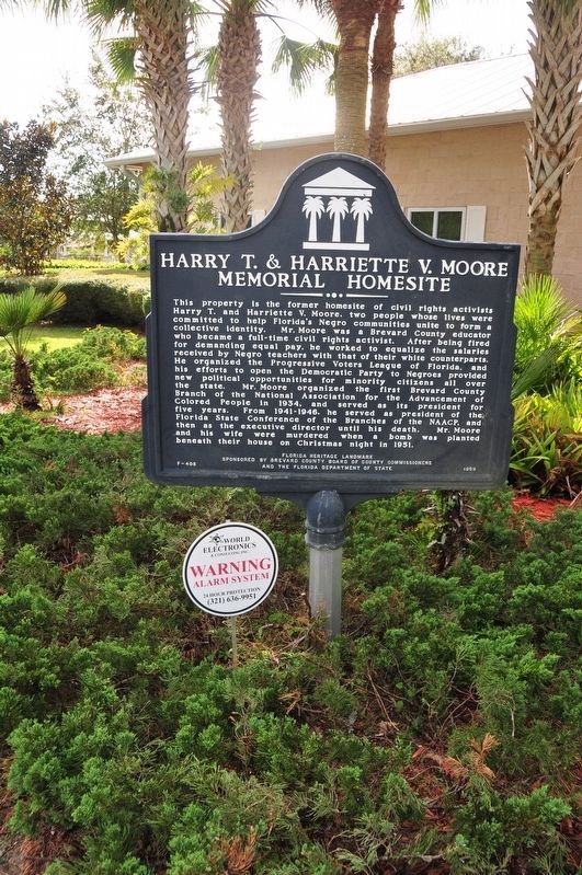
Near Freedom Avenue 0.3 miles south of Parker Street, on the left when traveling south.
This property is the former homesite of civil rights activists Harry T. and Harriette V. Moore, two people whose lives were committed to help Florida’s Negro communities unite to form a collective identity. Mr. Moore was a Brevard County educator . . . — — Map (db m177798) HM
On Courtenay Parkway North (State Road 3) 0.3 miles north of Biolab Road, on the left when traveling north.
Indian River oranges, one of Florida's most outstanding products were developed in the 19th century by Douglas Dummett. The Dummett family immigrated from the Barbados in 1807. By 1825, Thomas Dummett had acquired sugar plantations on the east . . . — — Map (db m125643) HM
While there is disagreement among scholars, it is believed that this site may be in an area where Juan Ponce de Leon made landfall in April 1513. It has long been thought that this event took place near St. Augustine, based upon studies of de Leon's . . . — — Map (db m69481) HM
On Northeast Miller Street at Pollack Avenue Northeast, on the right when traveling south on Northeast Miller Street.
In the early twentieth century, the North Dakota-based Florida Indian River Catholic Colony corporation advertised it was starting a Catholic community in central Florida. By 1914, the land company helped settle nearly 100 midwestern families, . . . — — Map (db m175719) HM
On Derby Street at Brevard Avenue, on the left when traveling west on Derby Street.
Dedicated on July 13, 1924, this structure was built by the Seventh Day Adventist Church, and was heralded by The Cocoa Tribune as “an honor to the City.” In 1955 it was sold to the Church of Christ, Scientist. In 1964 it was sold to the . . . — — Map (db m125640) HM
On Snowy Egret Drive at East Jay Road, on the right when traveling north on Snowy Egret Drive.
This site derives its name from the Oliver family who migrated from Missouri and homesteaded this area of Turnbull Hammock in the early 1870’s. They owned large tracts of timberland and citrus groves, and the main “camp” was located on this . . . — — Map (db m72737) HM
On Ramp Road 0.2 miles west of South Brevard Avenue, on the left when traveling west.
The Thousand Islands formed as the result of an ancient tidal inlet that breached this barrier island and flowed across modern-day Cocoa Beach. The indigenous Ais people, a fisher-gatherer society, lived along the inlet. Their oyster-shell middens . . . — — Map (db m112180) HM
On Harry T. Moore Avenue at Ricard Street, on the right when traveling south on Harry T. Moore Avenue.
In 1894, after organizing a congregation, St. James Colored Missionary Baptist Church acquired land in Mims, and with Rev. G. Brewer as pastor, built the first wooden church on this site in 1904 under the guidance of Rev. J.S. Gilbert. Many of North . . . — — Map (db m101402) HM
On Old Dixie Highway at Briarwood Lane, on the left when traveling south on Old Dixie Highway.
Founded by Tom Johnson Cockshutt in 1869, this was the first organized Protestant Church on the East Coast of Florida between New Smyrna and Key West. Tom donated land for a cemetery and built a small log structure located on what is now the . . . — — Map (db m101179) HM
On Old Dixie Highway at Diamond Road, on the left when traveling south on Old Dixie Highway.
In the early 1900s, a two acre parcel of land north of LaGrange Community Church and Cemetery was given to the Mims colored community for a cemetery. Earliest marked graves are dated 1903; many are unmarked. In the 1800s both blacks and whites . . . — — Map (db m101403) HM
On U.S. 90 at Mills Street, on the right when traveling east on U.S. 90.
Harry Tyson Moore was born on November 18, 1905, in Houston, a rural unincorporated community near Live Oak. He was the only child of Johnny and Rosa Moore. His father worked for the railroad and owned a small store in the front of their house. . . . — — Map (db m199928) HM
On Pineapple Avenue at Law Street, on the left when traveling south on Pineapple Avenue.
The William H. Gleason House was built around 1884 by William Henry Gleason (c. 1830-1902) and his wife Sarah Griffin Gleason. Gleason came to Florida in 1866 with his wife and two sons from Eau Claire, Wisconsin, and settled in Dade County. In . . . — — Map (db m63911) HM
On Sykes Creek Parkway at Old Audubon Road, on the right when traveling south on Sykes Creek Parkway.
The Ais were one of the most influential and powerful tribes in Florida when Spanish Army Lt. Alvaro Mexia mapped Ulumay Lagoon in 1605. He wrote in his diary “Here is the town of Ulumay, the first one of the province of Ais. In back of and . . . — — Map (db m72602) HM
On Indian River Drive (County Road 515) 0.1 miles south of Briarwood Lane, on the left when traveling north.
Known as City Point, this area was settled shortly after the Civil War by Confederate veterans, citrus grove workers, northern winter residents, and consumptives seeking a healthy climate. By early 1885, a board of trustees was formed consisting of . . . — — Map (db m203571) HM
On Delannoy Avenue north of Church Street, on the right when traveling north.
On October 31, 1916, citrus grower and inventor Edward Postell Porcher and wife Byrnina Peck Porcher, moved into what was the grandest house in Cocoa. The house is a unique example of Neo-Classical Revival Style architecture interpreted in coquina . . . — — Map (db m112182) HM
On 4th Avenue at North Miramar Avenue (State Road A1A), on the left when traveling east on 4th Avenue.
The Indialantic Casino was constructed on this site in 1923. The two-story Mediterranean Revival style building was designed by architect William Christen and developed by Herbert Earle. It opened on December 22, 1923, and boasted shops, an . . . — — Map (db m81316) HM
In 1605 Florida's Spanish Governor Pedro de Ybarra sent Lt. Alvaro Mexia on a diplomatic mission to the Ais Indians. Mexia recorded his passage from St. Augustine down the coast to the principal Ais Indian town near present-day Vero Beach. At the . . . — — Map (db m82927) HM
On Peachtree Street at West Strawbridge Avenue, on the left when traveling north on Peachtree Street.
First organized in 1884, Holy Trinity Episcopal Church was erected in 1886 on land donated by Lucy Boardman, who also provided plans for the building. Founding members of the congregation included the Goode, Campbell, Miller, Ely, Ellis and Grubb . . . — — Map (db m52927) HM
On Highland Avenue at Hector Street on Highland Avenue.
Descended from 17th Century New England pioneers, James Rossetter (1863-1921) was born in Hamilton County, Florida. Rossetter arrived in Eau Gallie in 1902 and became a leader in the local fishing industry, harvesting the many local waterways as a . . . — — Map (db m49214) HM
On State Road A1A at Old Florida Trail, on the left when traveling north on State Road A1A.
Under the United States Government Homestead Act of 1862, brothers Robert Toombs Smith and Charley Smith laid claim to 158.79 acres on Mullet Creek in 1887. They discovered the property while searching the Indian River Lagoon shoreline by sailboat . . . — — Map (db m102830) HM
On South Tropical Trail (County Road 3) at Crooked Mile Road, on the right when traveling south on South Tropical Trail.
In 1892, Frank Cass Allen, a Georgiana merchant, began building a 0.6-mile standard-gauge railway with steel rail and wood ties across Merritt’s Island at this location, connecting docks on the Indian and Banana Rivers. It was part of his private . . . — — Map (db m94408) HM
On South Tropical Trail (County Road 3) at Crooked Mile Road, on the right when traveling south on South Tropical Trail.
Georgianna United Methodist Church was built in the community of Georgiana on Merritt's Island in 1886. The ringing of the church bell still marks the beginning of worship as it has for many decades. Franklin C. Allen, Jr., a local homesteader, . . . — — Map (db m102267) HM
On North Tropical Trail at Pioneer Road, on the left when traveling north on North Tropical Trail.
In 1868, the Field family landed on Merritt Island to start a new life. A year later, much of the family returned to Macon, Georgia, but the two eldest brothers John R. (J.R.) and Samuel J. (Sam) Field remained. Using the Homestead Act of 1862, they . . . — — Map (db m140801) HM
On Old Dixie Highway just south of Diamond Road, on the left when traveling south.
Established in 1869, this is the oldest cemetery on Florida's lower East Coast. The oldest portion is located in the front center section, evidenced by the southeasterly positioning of the tombstones. Tom Johnson Cockshutt (1841-1917), who arrived . . . — — Map (db m101404) HM
Native Americans, explorers and settlers hauled or carried canoes and small boats over this narrow strip of land between Mosquito Lagoon and the Indian River. Eventually it became known as the “haulover.” Connecting both bodies of water . . . — — Map (db m108012) HM
On South Palm Avenue at Pine Street, on the right when traveling south on South Palm Avenue.
Brevard County was founded in 1855 and Titusville became the county seat in 1879. The first courthouse was a two-story classical revival wood structure built in 1882, on land donated by Titusville founder Col. Henry Titus. In 1912, County . . . — — Map (db m164308) HM
On Windover Way at Windover Trail on Windover Way.
Discovered by accident in 1982, the Windover site is a burial place of Early Native Americans who inhabited this region 7,000 to 8,000 years ago. The burials were placed underwater in the peat of the shallow pond. This peat helped to preserve . . . — — Map (db m60342) HM
Near North Tropical Trail at Possom End Road, on the left when traveling north.
The Sams family came to Brevard County from South Carolina in 1875 to take advantage of the 1860 Homestead Act. The family consisted of John Hanahan Sams, his wife Sarah, their five children, John's brother William Sams, and his sister, Catherine . . . — — Map (db m176325) HM
Near Freedom Avenue 0.3 miles south of Parker Street, on the left when traveling south.
The Civil Rights Movement in Florida began with the early work and untimely death of Harry T. Moore, an African-American civil rights worker in Brevard County. Harry Tyson Moore was a teacher, a principal, and civil rights worker. He became the . . . — — Map (db m177877) HM
On Rockledge Drive at Valencia Road, on the right when traveling south on Rockledge Drive.
The Valencia Historic District was developed during the Florida Land Boom of the 1920s. The Valencia Homes Company was formed in 1924 by local businessmen C. Sweet Smith, Charles D. Smith, L. S. Andrews and Horace R. Bruen. The company acquired a . . . — — Map (db m70298) HM
This community hall was constructed, circa 1941, as a barracks on the Banana River Naval Air Station. Following World War II, the Naval Air Station became Patrick Air Force Base. In 1948, this building was declared surplus, and sold to the American . . . — — Map (db m52733) HM
On West Emmett Street (U.S. 17) east of South Rose Avenue, on the right when traveling east.
Osceola County was created in May, 1887 from portions of Orange and Brevard Counties. One of its sponsors was Senator J. Milton Bryan, who suggested the new county be named for Osceola, the great Seminole warrior. The new county was Florida's . . . — — Map (db m54022) HM
On East Davidson Street east of North Broadway Avenue, on the right when traveling east.
Polk County was established February 8, 1861 formed from eastern Hillsborough County and western Brevard County and comprised one of two counties created after the state's secession from the union. Polk County was named after James Knox Polk the . . . — — Map (db m54003) HM
On Courtenay Parkway North (State Road 3), on the left when traveling south.
Before the Clifton Schoolhouse was built, Butler Campbell and Andrew Jackson’s children were home schooled by a black teacher, Mr. Mahaffey. The teacher was paid five dollars for each student, after examination by the County School Superintendent. . . . — — Map (db m278296) HM
On Lighthouse Road, on the left when traveling north.
On May 21, 1838, Florida territorial delegate Charles Downing requested a lighthouse be built on Cape Canaveral. The first lighthouse completed in Jan. 1848 stood 65-feet tall, had a 55-foot tower and a 10-foot lantern room equipped with 15 lamps on . . . — — Map (db m64798) HM
On Center Street at Sevilla Court, in the median on Center Street.
Before modern construction a complex of six burial mounds occupied this location. They were built by the ancestors of the prehistoric Ais tribe, a group who occupied the Cape Canaveral area at the time of European contact. Based on pottery styles . . . — — Map (db m243353) HM
On Church Street at Riverside Drive, on the left when traveling east on Church Street.
On June 2, 1878, the Right Reverend John Freeman Young, Bishop of Florida, and Dr. William H. Carter of Holy Cross Church of Sanford, Florida, held the first meeting of St. Mark’s Episcopal Church at a nearby Rockledge residence. The mission was . . . — — Map (db m70299) HM
On Delannoy Avenue at West King Street (Florida Route 520), on the right when traveling north on Delannoy Avenue.
(side one) Founded in 1885, the S.F. Travis Company is the oldest continuously operating business in the city of Cocoa and one of the oldest hardware stores in Florida. Surviving two world wars, numerous hurricanes, and financial busts, the . . . — — Map (db m145953) HM
On West City Avenue (U.S. 1), on the right when traveling north.
Atley Bensen paid $1,200 for the precut yellow pine lumber which arrived by riverboat from Jacksonville in 1916, to build this house for his wife Clara Christensen. The Bensen brothers married the Christensen sisters, both pioneer families of Grant. . . . — — Map (db m55099) HM
Near Thomas Barbour Drive 0.5 miles north of U.S. 1.
The Ais Indian town of Pentoaya is thought to have been located atop the arc-shaped sand bluffs that surround the western edge of what is now Ballard Park. Pentoaya was an important prehistoric Indian settlement on the east coast of Florida, and was . . . — — Map (db m82819) HM
On Strawbridge Avenue (U.S. 192) at U.S. 1, on the right when traveling west on Strawbridge Avenue. Reported damaged.
The First Congregational Church of Melbourne had its beginnings in 1887 when Edward Branch and his wife Abbie began to hold regular Bible study and worship meetings. In December 1887, five men and seven women signed a covenant that was the first . . . — — Map (db m310730) HM
On Mill Street east of Lipscomb Street, on the left when traveling east.
The Union Cypress Co. was Melbourne’s first big industry, bringing employment, growth and development to the region. Their big cypress/pine sawmill was a three-story, all-steel structure about 50 by 150 feet. Five, 150-horsepower boilers provided . . . — — Map (db m71092) HM
On Ocean Avenue, on the right when traveling west.
Constructed on this site in 1888, Myrtle Cottage was built by Mrs. Hannah Cummings and her daughter Grace, and was the first house in the area known as Melbourne Beach. The house's construction was made difficult by the lack of roads or docks, and . . . — — Map (db m52569) HM
This building was constructed in 1908 facing the Indian River Lagoon in the area now know as Ryckman Park in Melbourne Beach. It originally held offices of the Melbourne Beach Improvement Company. The officers, Capt. Rufus Beaujean, son Donald . . . — — Map (db m53166) HM
On North Tropical Trail at Northgrove Drive, on the left when traveling north on North Tropical Trail.
Established in 1892, the Bethel A.M.E. Church of Merritt Island was the first African Methodist Episcopal church on North Tropical Trail, located on land James R. Ragan originally acquired through the Homestead Act in 1895. The wooden church sat on . . . — — Map (db m101067) HM
On Bevis Road 0.3 miles south of Lucas Road, on the right when traveling north.
Dennis Sawyer Memorial Park was established in 1956 when R.V. and Hazel Woods deeded three acres of land for use as an African American cemetery. It was originally managed by Greater Mount Olive AME Church, but years later, the cemetery deteriorated . . . — — Map (db m192604) HM
On South Tropical Trail (County Road 3) at Old Settlement Road, on the right when traveling south on South Tropical Trail.
Provost Hall was originally constructed in 1910 as the Georgiana Club house on land provided by Charles D. Provost and his wife Gertrude Breese Provost. Until their grandchildren, Charles D. Provost and his sister, Mary Virginia Provost Katz, gave . . . — — Map (db m94407) HM
On North Tropical Trail 0.1 miles south of Sawyer Avenue, on the right when traveling north.
Edwin Dennis Sawyer (1874-1964) was born in the Bahamas, the second child of freed slave Alfred Sawyer. From age 18-25, Dennis worked on a ship and then in Ft. Pierce as a fisherman. In 1898, after moving to Cocoa, he married Rebecca Dallas. The . . . — — Map (db m192603) HM
On Rockledge Drive (State Road 515) 0.2 miles south of Barton Avenue, on the right when traveling south.
This house is one of the last remaining examples of Queen Ann architecture in the area. The tall proportions, a variety of surface textures and the irregularity of plan are representative of this style. One of the most predominant characteristics is . . . — — Map (db m102297) HM
In 1911, Edgar W. Ellis and J. H. Beckwith put together a consortium of developers known as the Titusville Fruit and Farm Lands Company. They acquired 22,500 acres in the western portion of the old Delespine Grant with plans to drain marshland in . . . — — Map (db m50129) HM
Near A. Max Brewer Memorial Parkway (County Road 402) 0.4 miles east of Indian River Avenue.
This pier was the western end of Walker Bridge, the first bridge linking Titusville to Merritt Island. Built in 1922, the hand-cranked, wooden drawbridge served the area until preparations for a modern causeway began in the late 1930s. Causeway . . . — — Map (db m100950) HM
On Hollywood Boulevard, on the right when traveling south.
This 18.5-mile standard-gauge railway was built to carry logs from the large cypress/pine holdings of George W. Hopkins, at Deer Park, to the Union Cypress sawmill just south of Melbourne. Two new and seven used steam locomotives would eventually . . . — — Map (db m52423) HM
On Barge Canal Circle 1 mile north of Marine Harbor Dr, on the left when traveling north.
Indianola Pioneer cemetery is the final resting place of early white settlers who carved homesteads out of the lush growth of the Florida peninsula. It was created on November 4, 1898, when Thomas H Sanders and his wife, Mary recognized that the . . . — — Map (db m240075) HM
Near Dr Martin Luther King Jr Boulevard at East Virginia Avenue, on the left when traveling north.
The Bailey Brothers served the United States of America honorably World War II, the Korean War and the Vietnam War
Archie and Josephine Bailey were married in 1905 and made Punta Gorda their home. They raised their large family in their . . . — — Map (db m249137) HM
On Avenue D at North 16th Street, on the left when traveling east on Avenue D.
Former Chronicle Newspaper Headquarters, 1529 Avenue D
Florida was still segregated when innovative publisher C.E. Bolen, a leader in the Ft. Pierce black community, began publication of The Chronicle a weekly newspaper written by . . . — — Map (db m202541) HM
On South Palm Avenue at Pine Street, on the left when traveling south on South Palm Avenue.
This building was constructed to house the offices of the Clerk of the circuit Court, when the nearby wood framed courthouse was thought to be unsafe for storing Brevard County Records. The contract was awarded to L.R. Decker & Co., and was . . . — — Map (db m164329) HM
On South Washington Avenue at Pine Street, on the left when traveling north on South Washington Avenue.
Captain James Pritchard bought a lot from Mary Titus, and in the spring of 1891 contracted Pleasant J. Hall, who had built St. Gabriel's Episcopal Church, to build a Queen Anne style house of heart pine. It appears today much like it did then. On . . . — — Map (db m25752) HM
Near South Washington Avenue (U.S. 1) at Pine Street.
Members of Rodney's family moved to Florida before the Civil War, and in the 1890's moved to Merritt Island. In the early 1900's grandfather James Thompson operated a sawmill near Fox Lake. Rodney was born in 1930 to parents Herbert Thompson and . . . — — Map (db m195905) HM
On Indialucie Parkway at North Sewall's Point Road (County Road 707), in the median on Indialucie Parkway.
Dr. William H. Baker and his family settled here in 1880 and named the place Waveland. Their home was the first permanent residence in what is Martin County today, and Waveland was prominent on Florida maps for many years. The section line that . . . — — Map (db m112169) HM
On Kempfer Road at E. Bronson Highway (U.S. 192), on the left when traveling south on Kempfer Road.
In 1895 George Washington Hopkins from Michigan began buying land in eastern Osceola and Brevard County. He founded the Union Cypress Company, operating a saw and planing mill in Hopkins, a small town south of Melbourne. Deer Park was founded to . . . — — Map (db m221629) HM
Near Dave Nisbet Drive 0.2 miles west of George J. King Boulevard, on the right when traveling west.
Florida’s largest lock connects the ocean to the Banana River. Ships, fishing and pleasure boats, barges and even space vehicles use Canaveral Lock to access the Port. Gates on the extra-wide lock open to adjust water levels. This ensures . . . — — Map (db m164418) HM
Near North Wickham Road at Murrell Road, on the right when traveling east.
In 1991, A. Duda & Sons, a corporation privately held by the Duda family, donated 56 acres of land here within the New Town community of Viera to the people of Brevard County as a site for the new Brevard Zoo. The land is part of a 38,000-acre tract . . . — — Map (db m188676) HM
Near Harrison Street at Riveredge Boulevard, on the left when traveling west.
Born 20 December 1929 at New Smyrna, Florida. Moved to Brevard County March 15, 1936. A 1948 graduate of Cocoa High School. Enlisted in the U.S. Army July 25, 1950. Killed in action June 24, 1951. His grave in Pinecrest Cemetery is properly marked. . . . — — Map (db m145975) HM WM
On Space Port Way at Poseidon Avenue, on the left when traveling east on Space Port Way.
Prime Contractor: North American Aviation
Type: Intercontinental Guided Missile
The Navaho was a rocket-launched, air breathing, long-range intercontinental guided missile. The Navaho was considered to have the range, accuracy, and . . . — — Map (db m164869) HM WM
On South Palm Avenue at Pine Street, on the right when traveling south on South Palm Avenue.
To the honor
of
Brevard County boys
who gave
their services
in the World War
This tablet is dedicated
in gratitude and pride
by
Phillip Perry Chapter
Daughters of the American Revolution
Titusville, Florida . . . — — Map (db m164318) WM
Near Babb Road 0.2 miles north of Princess Lane, on the right when traveling north. Reported permanently removed.
After the conclusion of the Civil War, an influx of pioneers moved to the wilds of central Florida to farm and raise cattle. Kissimmee City began as a trading post, and Shingle was the location of an area post office and shingle mill. The early . . . — — Map (db m219936) HM
Thin black lines indicate changes in relevance. Between each pair of lines entries are ordered geographically but all have the same relevance.
* Inflectional forms of words are their plurals, singulars, and possessives as well as gramatical tenses and similar variations.