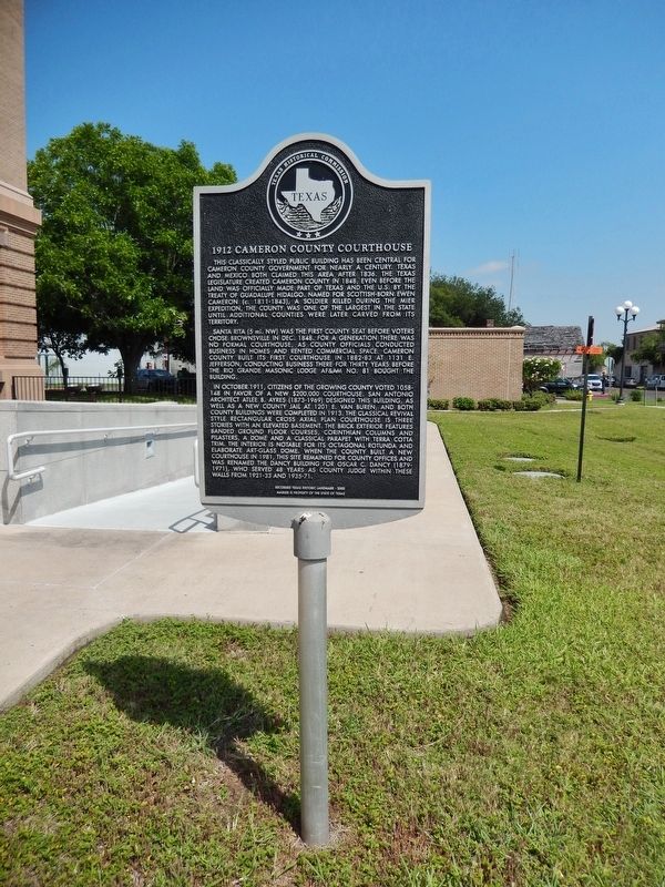
On East Monroe Street north of East 12th Street, on the left when traveling north.
This classically styled public building has been central for Cameron County government for nearly a century. Texas and Mexico both claimed this area after 1836. The Texas Legislature created Cameron County in 1848, even before the land was . . . — — Map (db m118643) HM
On East Saint Charles Street at East 5th Street, on the left when traveling south on East Saint Charles Street.
Civil Rights advocate, legislator and attorney José Tomás Canales was born on a ranch in Nueces County to Andreas and Tomasa (Cavazos) Canales. As a young man, he moved to Kansas City, where he completed high school. In 1896, Canales began attending . . . — — Map (db m223565) HM
On Sabal Palm Grove Road 1 mile south of Southmost Boulevard (Farm to Market Road 1419), on the right when traveling south.
Today, commonly referred to as the Rabb Plantation, this was originally known as Rancho San Tomas and then, San Tomas Plantation. It encompassed 20,353 acres stretching north from the banks of the Rio Grande to the Arroyo Colorado. In 1885, . . . — — Map (db m165628) HM
On Queen Isabella Causeway 0.1 miles west of Padre Boulevard, on the right when traveling north.
Padre Island, off the South Texas coast, is named for Padre Jose Nicolas Balli (177?-1829), whose family migrated from Spain in 1569 and became large landowners in the Lower Rio Grande Valley. In 1800 Balli applied to King Charles IV of Spain for . . . — — Map (db m156300) HM
Stephen Powers was a captain of volunteers with Zachary Taylor's army at Matamoros and was promoted to commander of an American garrison under Gen. Winfield Scott (1847). He became Cameron county judge in 1858. He served as 12th District judge . . . — — Map (db m222160) HM
On South 7th Street (Business U.S. 77) at West Riggs Avenue, on the right when traveling north on South 7th Street.
Born in a log house on Congress Avenue, Austin, son of Republic of Texas lawyer and newspaperman N. C. Raymond and wife Lucinda (Riggs), E. B. Raymond came on horseback to South Texas in 1870. After herding cattle uptrail to Kansas, he was hired . . . — — Map (db m269642) HM
On East Saint Charles Street near East 3rd Street, on the left when traveling south.
This structure, with its molded cornice, is a good example of the large brick residences erected in Brownsville in the late 19th Century. It was built in 1894 for Mary Josephine Glaevecke Browne, widow of Cameron County Sheriff Matthew L. ("Theo") . . . — — Map (db m295626) HM
Near Sam Perl Boulevard at East St. Charles Street.
Ferry service along this stretch of the Rio Grande evolved as population in the area increased. In 1836, General Jose Urrea used rowboats at the Paso Real ferry near the later site of Fort Brown en route to Goliad. General Vicente Filisola used . . . — — Map (db m165671) HM
On Madeley Avenue at Tamm Street, on the right when traveling west on Madeley Avenue.
James Henry Dishman was forced at the age of six to assume a man's role after his father's death in the Civil War in 1864. A native of Cherokee County in East Texas, he eventually moved to Kaufman County and developed a successful ranching . . . — — Map (db m261719) HM
On South Garcia Street at East Hickman Avenue, on the left when traveling south on South Garcia Street.
Built by 1906 to lodge Rio Grande Railroad Company passengers and tourists, especially fishermen and hunters, the Queen Isabel Inn was first known as "Point Isabel Tarpon & Fishing Club". The hotel hosted family train excursions from Brownsville . . . — — Map (db m165640) HM
On Colorado Avenue (County Highway 106) at North Arroyo Boulevard, on the right when traveling west on Colorado Avenue.
The Arroyo Colorado is the Lower Rio Grande Valley’s only natural waterway besides the Rio Grande. The 89-mile stream extends from mission in Hidalgo County to the lower Laguna Madre in Cameron County. From early colonization in the late 1700s, the . . . — — Map (db m195622) HM
Near North Main Street (U.S. 87) at West Red River Street.
Served in Co. D, Texas Rangers (1927-1933), under Captains W.W. Sterling, Will Wright, and Albert Mace. Hazardous duties included patrolling the Rio Grande for smugglers, protecting a prisoner from a Sherman lynch mob, dipping cattle for tick fever . . . — — Map (db m192587) HM
On East Monroe Street south of East 11th Street, on the right when traveling north.
Planned as all of block 144 of the original townsite in 1848 and active by 1852, Campo Santo Viejo was the first official cemetery in Brownsville.
The city abandoned the site in 1864, but burials continued into the 1870s.
The property was . . . — — Map (db m117901) HM
On West Jackson Avenue at South Commerce Street, on the left when traveling west on West Jackson Avenue.
Prior to construction of the Planters State Bank building, a barber shop owned by Harlingen pioneer Mack Crenshaw was located at this site. In 1917, the land was deeded to the Planters State Bank. The owners of the bank leased the upper floors of . . . — — Map (db m221110) HM
On Mallory Street at East La Parra Avenue, on the right when traveling north on Mallory Street.
English:
The town of Sarita was chartered in 1903 and the St. Louis Brownsville & Mexico Railroad reached here in 1905. The depot stood just down La Parra Avenue where the tracks cross it. Although the depot was torn down in the 1970s, . . . — — Map (db m118067) HM
On East Van Buren Street south of East 12th Street, on the right when traveling north.
Originally built as a three-story structure in 1912, this building, Cameron County's second jailhouse, was enlarged with the addition of a 4th floor about 1929. The 1912 structure was designed by prominent architect Atlee B. Ayers and the 1929 . . . — — Map (db m117886) HM
On East Jefferson Street at East 12th Street, on the right when traveling north on East Jefferson Street.
Completed in 1883, this was the first courthouse built by Cameron County officials, who previously rented or purchased office space. This three-story brick structure served as the county courthouse until 1914, when a new building was erected. Rio . . . — — Map (db m117935) HM
On East Washington Street (Business U.S. 77) south of East 13th Street, on the right when traveling north.
English:
Built in 1850 in Greek Revival style by Henry Miller, who operated the nearby Miller Hotel, for Brownville founder, Charles Stillman, and his new bride, Elizabeth.
They occupied the house until 1853 and their first two children . . . — — Map (db m117854) HM
Israel Bonaparte Bigelow was from Connecticut and was a stage coach operator for General Taylor. He became the first County Judge of Cameron County and Brownsville's first Mayor but was ousted by the city council on twelve counts of election . . . — — Map (db m221952) HM
On East Madison Street 0.1 miles east of East 13th Street, on the right when traveling west.
Joseph Webb (1850-1933) had this residence constructed for his family about 1906. Known as Don "Pepe", Webb served as clerk of Cameron County for 34 years. In 1929 he conveyed the house to a daughter, Josephine Webb, a Brownsville teacher for whom a . . . — — Map (db m222834) HM
The Harlingen Cemetery came into legal existence in 1912. In that year, Lon C. Hill (1862-1935), founder of the city of Harlingen and president of the Harlingen Land and Water Company, sold 7.6 acres of land at this site for one dollar to trustees . . . — — Map (db m221150) HM
On 2nd Street at South Ohio Street, on the left when traveling east on 2nd Street.
Land developer B.F. Yoakum saw agricultural potential along the Rio Grande and found investors in 1905 for an irrigation project. They purchased 250,000 acres and the townsite of Mercedes for business headquarters. The pump station began operating . . . — — Map (db m165812) HM
On South Padre Island Drive (Highway 22) at Padre Balli Park Road, on the left when traveling south on South Padre Island Drive.
First called Corpus Christi Island or Isla Santiago, Padre Island was named for Padre Jose Nicolas Balli (1772-1829). His family migrated from Spain in 1569 and became large landowners in the Lower Rio Grande Valley, influential in military and . . . — — Map (db m182904) HM
On East Elizabeth Street at East 12th Street (Business U.S. 77), on the left when traveling south on East Elizabeth Street.
Built 1850 by Wm. C. Douglas, who arrived with Gen. Zachary Taylor during Mexican War.
In 1852 by order of U. S. Congress, first Federal Court in Brownsville was held in back room here by Judge John Watrous.
Recorded Texas . . . — — Map (db m202024) HM
On Capt Donald L Foust Road at North Indiana Street, on the right when traveling east on Capt Donald L Foust Road.
The first serious attempt to study the possibility of construction of a deep water seaport in this part of South Texas was undertaken in 1854 when a survey was conducted by United States Army engineers. At that time, the only natural harbor in the . . . — — Map (db m201995) HM
Emilio Forto managed the properties of James Stillman for over forty years. He served as mayor and sheriff (1892), Cameron County Judge, was a banker and served on the Brownsville School Board (1892). He founded the Brownsville Country Club and . . . — — Map (db m221950) HM
Francisco Yturria was the son of a captain in the Spanish Army in Matamoros. He married Felicitas Treviño, a Spanish land grantee. He started as a clerk for Charles Stillman and worked for Mifflin Kenedy and Richard King. During the Civil War he . . . — — Map (db m221962) HM
On South F Street at W Garfield Ave on South F Street.
Recent History
The west section of the Harlingen City Cemetery was first surveyed in 1962 by the Tip-O-Texas Genealogical Society.
On May 17, 2008, members of the newly formed Hispanic Genealogy Group agreed to photograph and transcribe . . . — — Map (db m301432) HM WM
Thin black lines indicate changes in relevance. Between each pair of lines entries are ordered geographically but all have the same relevance.
* Inflectional forms of words are their plurals, singulars, and possessives as well as gramatical tenses and similar variations.