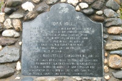
On Iowa Hill Road 9 miles south of Interstate 80, on the left when traveling east.
Gold discovered here in 1853 and by 1856 weekly production estimated at one hundred thousand dollars. The total value of gold produced up to 1880 is placed at twenty million dollars. Town was destroyed by fire in 1857 and again in 1862 but each . . . — — Map (db m44036) HM
On Main Street at Diggins Hill Road on Main Street.
Founded in the Spring of 1861 by Joseph and Charles Dornbach. From 1854 to 1882 it was noted for its rich hydraulic mines. In 1860 had the largest voting population in Placer County. Chinese inhabitants numbered about 2,000. Here Theodore Judah and . . . — — Map (db m549) HM
On Highway 80 (Interstate 80), on the right when traveling west.
The spring of 1845 saw the first covered wagons to surmount the Sierra Nevada Mountains. They left this valley, ascended to the ridge and turned westward to Old Emigrant Gap. The wagons were lowered by ropes to the floor of Bear Valley. Hundreds . . . — — Map (db m548) HM
Native Sons of the Golden West are proud to donate this plaque to commemorate the
Pioneers of Deadwood
Placer County,
California
Those gold seekers developed a mining community here along the El Dorado Trail which also served such . . . — — Map (db m678) HM
On Hampshire Rocks Road, on the left when traveling east.
It is estimated more than 30,000 settlers came into California over this trail in the year 1849. Near this site outcroppings of rocks still bear the marks of wagon wheels. For those travelers who reached this point the next ordeal was the tortuous . . . — — Map (db m95507) HM
On Michigan Bar Road at Highway 16, on the left when traveling north on Michigan Bar Road.
(left panel)
Michigan Bar
Gold was discovered on the Cosumnes River in 1849 by two men from Michigan in the vicinity of the historic Nisenan settlement of Palamul. In the 1850s the town of Michigan Bar was the largest in Cosumnes . . . — — Map (db m2037) HM
On East Grass Valley Street, on the right when traveling south.
Central Pacific Railroad reached Colfax, formerly Illinoistown September 1, 1865, and train service began four days later. Colfax was a vital construction supply depot and junction point for stage lines for ten months. It was renamed Governor . . . — — Map (db m13081) HM
On Yankee Jims Road at Spring Garden Road, on the right when traveling north on Yankee Jims Road.
Gold was discovered here in 1850 by 'Yankee Jim,' a reputed lawless character, and by 1857 the town was one of the most important in Placer County. The first mining ditch in the county was constructed here by H. Starr and Eugene Phelps. Colonel . . . — — Map (db m11924) HM
On Main Street at Page Street, on the right when traveling south on Main Street.
Regular freight and passenger trains began operating over the first 31 miles of Central Pacific's line to Newcastle on June 10, 1864, when political opposition and lack of money stopped further construction during that mild winter. Construction was . . . — — Map (db m11141) HM
On Virginiatown Road 0.2 miles east of Fowler Road, on the left when traveling east.
Founded June 1851 - Commonly called 'Virginia.' Over 2,000 miners worked rich deposits. Captain John Brislow built California's first railroad, 1852, to carry pay to Auburn Ravine, a distance of one mile. Site of Philip Armour's and George Aldrich's . . . — — Map (db m10973) HM
On Lozanos Road at Bald Hill Road, on the right when traveling north on Lozanos Road.
Founded in 1849 as 'The Spanish Corral.' Area proved so rich that Biblical name of Ophir adopted in 1850. Most populous town in Placer County in 1852, polling 500 votes. Almost totally destroyed by fire in July 1853. Later became the center of . . . — — Map (db m11922) HM
On Rocklin Road south of Front Street, on the right when traveling north.
Central Pacific reached Rocklin, 22 miles from its Sacramento Terminus, in May, 1864, when the railroad established a major locomotive terminal here. Trains moving over the Sierra were generally cut in two sections at this point, in order to ascend . . . — — Map (db m11088) HM
Near Church Street just east of Washington Boulevard, on the right when traveling east.
Central Pacific graders reached Junction, now Roseville, on November 23, 1863, crossing the line of the California Central, which began building northward from Folsom in May 1858. That line was abandoned in 1868. CP’s track reached Junction . . . — — Map (db m11079) HM
On Lincoln Way west of Grass Valley Highway (California Highway 49/193), on the right when traveling west.
Instituted in 1852, the first Odd Fellows Lodge organized in Placer County, seventh in California. Meetings were held in several different locations until this building was erected in 1894. Bricks used in construction were made and fired on this . . . — — Map (db m31842) HM
On Lincoln Way at Elm Avenue, on the right when traveling north on Lincoln Way.
The Auburn depot is the fourth depot constructed (1902) on this hill. The original depot was constructed in 1865 when the Transcontinental Railroad came through Auburn. It burned down and was replaced in 1870. The second depot was sold and . . . — — Map (db m81586) HM
On Michigan Bluff Road (Route 402) at Church Street, on the right when traveling east on Michigan Bluff Road.
Founded in 1850 and first known as Michigan City which was located on slope one half mile from here. In 1858 town became undermined and unsafe so was moved to this location and renamed Michigan Bluff. Leland Stanford, who gained wealth and fame in . . . — — Map (db m691) HM
On Main Street at Washington Boulevard, on the left when traveling west on Main Street.
The story of Roseville's "Old Town" had its beginnings in the aftermath of the fabled
California gold rush when discouraged gold seekers left the mineral regions to take
up farming along the rich creek bottom lands of south western Placer County. . . . — — Map (db m135429) HM
1. Mormon Island Relocation Cemetery
In the late 1940s, plans to create the Folsom Dam at the confluence of the North and South Forks of the American River meant many acres of land would be flooded, including several historic cemeteries, . . . — — Map (db m128767) HM
On Ophir Road near Werner Road, on the right when traveling west.
This monument was erected in recognition of the historical significance of this transportation corridor by the Placer County Water Agency and dedicated to the California Chapter of the Lincoln Highway Association. Ophir Road was formerly U.S. 40 . . . — — Map (db m129960) HM
When the task of building the C.P.R.R. line over the Sierra provided too much for the Irish, Chinese laborers from Kwantung took over. Called Tze Yap or Four Districts Men, their hard work and perseverance earned them the nickname of “Cholly . . . — — Map (db m16941) HM
On Magra Road south of the Interstate-80, on the right when traveling west.
Founded in 1854 by O. W. Hollenbeck and originally called Mountain Springs. Famed for its hydraulic mines which from 1865 to 1878 shipped $6,125,000.00 in gold. Five large water ditches passed through the town serving the mining companies which had . . . — — Map (db m1101) HM
On Taylor Road at Rock Springs Road, on the right when traveling north on Taylor Road.
In the Fall of 1864, Mr. Griffith Griffith, a native of Wales, established the quarry located near this site which was later to supply high-quality granite for a number of the important buildings in San Francisco and Sacramento, including portions . . . — — Map (db m683) HM
Constructed in 1827 by the Mexican government to collect custom duties from foreign shipping, a principal revenue source when Monterey was the capital of Alta California, Mexico's northernmost province. Thomas O. Larkin, US consul to Alta . . . — — Map (db m82186) HM
On Lincoln Way at Park Street, on the right when traveling east on Lincoln Way.
Gold discovered near here by Claude Chana May 16, 1848. Area first known as "North Fork" or "Wood's Dry Diggings". Settlement given name of Auburn in Fall of 1849. Soon became important mining town, trading post and stage terminal. County seat of . . . — — Map (db m685) HM
On Foresthill Divide Road, on the right when traveling east.
Gold discovered here in 1850 in which year the first "Forest House" built. In 1852 the Jenny Lind Mine found which produced over million dollars in gold while the mines in this immediate vicinity produced over ten million dollars up to 1868. Town an . . . — — Map (db m672) HM
The Castro/Breen adobe is associated with the early development and settlement of Mexican California. The adobe is an excellent example of blended eastern and western building methods first produced in Monterey to form the Monterey Colonial . . . — — Map (db m82243) HM
History
In the old days, when it snowed over Donner Summit, the roads closed. Because an average of 34 feet of snow falls annually on Donner Summit, the roads over the pass closed in winter.
Wendell Robie and the Auburn Ski Club worked . . . — — Map (db m284662) HM
Near Lincoln Way east of College Way, on the right when traveling east.
[Kiosk Side A:]
Gold Discovered Just Downstream in Auburn Ravine!
On May 16, 1848, just downstream in Old Town Auburn where North Rich Ravine meets Auburn Ravine, gold was discovered by a Frenchman named Claude Chana. After leaving . . . — — Map (db m52355) HM
Near Fruitvale Road west of Stafford Lane, on the right when traveling west.
Fruitvale School
Fruitvale School District, formed in 1888, bought a one and half acre site from Jeremiah and Elizabeth Fowler on which this school was built in 1889. Lewis Gage was the first teacher here. Additions to the structure were made . . . — — Map (db m42040) HM
Thin black lines indicate changes in relevance. Between each pair of lines entries are ordered geographically but all have the same relevance.
* Inflectional forms of words are their plurals, singulars, and possessives as well as gramatical tenses and similar variations.