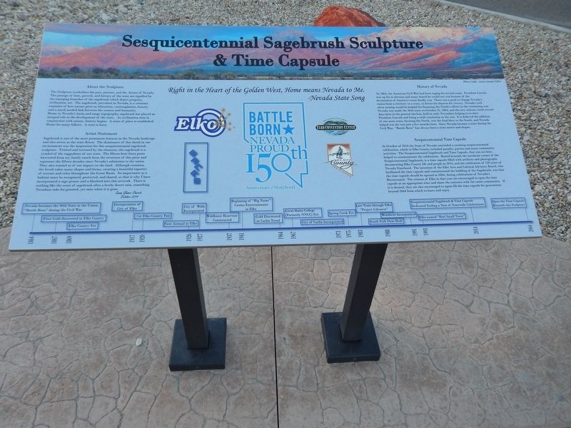
On College Avenue at Idaho Street, on the right when traveling east on College Avenue.
Right in the Heart of the Golden West, Home means Nevada to Me. Nevada State Song
About the Sculpture The Sculpture symbolizes the past, present, and the future of Nevada. The passage of time, growth, and history of the state are . . . — — Map (db m146799) HM
On Idaho Street, on the right when traveling west.
On December 29, 1868, representatives of the Central Pacific Railroad started laying out lots for the future town of Elko. By 1870, the thriving town had 5,000 people. There was an immense volume of freight and passenger traffic over the stageline . . . — — Map (db m1372) HM
On Riverside Drive, on the right when traveling west.
On the Trail Today
Whichever direction your travels take you, you are going to have a similar experience to what the California-bound emigrants had. You are going to see the same country, except for the towns and the ranch meadows. The big . . . — — Map (db m308270) HM
On Tomera Road near Nevada Route 278, on the right when traveling west.
By the time emigrants reached this spot, they had enjoyed fairly good traveling for the past ten days or so, as they followed the Humboldt River road. But here they faced their first big physical challenge along the route. If they stayed along the . . . — — Map (db m81204) HM
On Railroad Street at 7th Street, on the right when traveling north on Railroad Street.
Elkoans have always made education a
priority. Higher education came to Elko
with the establishment of the University of
Nevada in 1874 at Ninth and College. The
University was moved to Reno in 1885 as citizens
of western Nevada complained, . . . — — Map (db m142662) HM
On Court Street, on the right when traveling west.
In 1895, Nevada established the County High School Act. Built in 1896, this was the first school building in Nevada to be constructed under this act. The structure served as the Elko County Library from 1917 to 1974, when the county offices . . . — — Map (db m1345) HM
On North Main Street at Bateman Street, on the right when traveling north on North Main Street.
In 1873 separate stage coach owners Gilbert and Salsbury along with Hotel owner J.P. Withington organized the E&P to supply the Eureka Mining District. With the first train reaching Eureka on October 22 1875. This 87-mile-long narrow gauge train . . . — — Map (db m183755) HM
Austin City Hall (1866) Has been placed on the National Register Of Historic Places By the United States Department of the Interior & Austin Historical Society 2003 — — Map (db m89469) HM
Looking at the broad valley of the Humboldt River before you, close your eyes and imagine how it would have been in the mid-1800s. Instead of the sounds of traffic on I-80, you can almost hear the creak of wagon wheels. You might hear the sounds of . . . — — Map (db m81206) HM
On Main Street (California Route 152), on the right when traveling west.
After the California gold discovery in 1848, the rush was on from all parts of the nation to the mining regions of the West Coast. In early 1849, a young man named John Howard Watson arrived in California to seek his fortune. Stories have been . . . — — Map (db m21201) HM
On Lamoille Canyon Road (Forest Road 660) near Lamoille Highway (Nevada Route 227), on the right when traveling south.
The Army was seeking new routes west in 1854, so scouts set out to study the land in Central Nevada. The Huntingtons, Reese, and some teamsters had worked their way to Southern Elko County.
During a noon halt at the foot of the magnificent . . . — — Map (db m138452) HM
On Idaho Street 0.1 miles north of 14th Street, on the left when traveling north.
Whichever direction your travels take you, you're going to have a similar experience to what the California-bound emigrants had. You're going to see the same country, except for the towns and the ranch meadows. The big difference, though, is that . . . — — Map (db m146802) HM
According to the early history of Elko, Nevada, this curfew and fire bell played a vital role for local citizenry. It often rang to signal disastrous fires, deaths of celebrities, and celebrations.
Harbinger of both good tidings and bad, the . . . — — Map (db m201468) HM
On Idaho Street, on the right when traveling west.
Constructed on Sherman Creek in Huntington Valley, 60 miles south of Elko, by rancher Valentine Walther. It took Walther, family and friends seven years to complete and was finished in 1903. The house served as a home, post office, stage stop and . . . — — Map (db m1431) HM
Near U.S. 95 at Interstate 80, on the right when traveling south.
Whichever direction your travels take you, you're going to have a similar experience to what the California-bound emigrants had. You're going to see the same country, except for the towns and the ranch meadows. The big difference, though, is that . . . — — Map (db m67359) HM
On Genoa Lane at Main Street, on the right when traveling west on Genoa Lane.
Whichever direction your travels take you, you’re going to have a similar experience to what the California-bound immigrants had. You’re going to see the same country, except for the towns and ranch meadows. The big difference, though, is that . . . — — Map (db m98183) HM
Near Interstate 80 at milepost 292, on the right when traveling west.
Whichever direction your travels take you, you're going to have a similar experience to what the California-bound emigrants had. You're going to see the same country, except for the towns and the ranch meadows. The big difference, though, is that . . . — — Map (db m67507) HM
On Railroad Street at 7th Street, on the right when traveling north on Railroad Street.
Northern Nevada has been inhabited
for nearly 10,000 years. The Newe or
Western Bands of the Western Shoshone
Nation called this area home. The Newe
had seasonal campsites throughout
northern Nevada. During the spring,
they dispersed from the . . . — — Map (db m142657) HM
On April 6, 1926, Varney Air Lines pilot Leon Cuddeback, carrying one bag of mail, landed his tiny Curtis Swallow bi-plane at Elko, Nevada, completing the first scheduled air mail run in the United States.
The single engine, 90-horsepower . . . — — Map (db m1371) HM
On Idaho Street 0.2 miles north of 14th Street, on the left when traveling north.
The Pony Express was the first attempt to have fast mail service to California. This was done through the personal drive and bravery of very young men who were responsible for bringing the mail and other “Deliverables” to the western . . . — — Map (db m146800) HM
Near Interstate 80 at milepost 258, on the right when traveling east.
Whichever direction your travels take you, you're going to have a similar experience to what the California-bound emigrants had. You're going to see the same country, except for the towns and the ranch meadows. The big difference, though, is that . . . — — Map (db m67440) HM
Near Interstate 80 at milepost 187, on the right when traveling west.
Whichever direction your travels take you, you're going to have a similar experience to what the California-bound emigrants had. You're going to see the same country, except for the towns and the ranch meadows. The big difference, though, is that . . . — — Map (db m67431) HM
Near U.S. 395 0.1 miles south of Pangborne Lane, on the right when traveling south.
On the date of March 26, 1872, an earthquake of major proportions shook Owens Valley and nearly destroyed the town of Lone Pine.
Twenty seven persons were killed.
In addition to single burials, 16 of the victims were interred in a . . . — — Map (db m34157) HM
Near Western Pacific Way 0.2 miles west of Main Street.
The unique history of this passenger car makes it one of the most important artifacts in the museum's collection. When built by the famous Pullman Company in 1917, this car was named the "Pioneer" and was part of Pullman's executive lease fleet, . . . — — Map (db m163303) HM
On Museum Avenue near Maple Avenue, on the left when traveling west.
The growth of the American auto industry in the early 20th century transformed America. Americans embraced their new freedom to explore, leading to a demand for transcontinental auto routes. In 1921, the Federal Highway Act was passed and the . . . — — Map (db m141450) HM
On Earthquake Fault Road 0.3 miles south of U.S. 50, on the right when traveling south.
When the energy from pressure built up underneath the Earth's thin crust is suddenly released, an earthquake occurs. At first the crust may just bend. But if the stress is great enough, the rocks will break and "snap" to a new position. This . . . — — Map (db m62121) HM
On W. Hamilton Street at B Street, on the left when traveling west on W. Hamilton Street.
Carlin, the oldest town in present Elko County, was established as a railroad division point in December 1868, by the Central Pacific Railroad. It was named, by Central Pacific officials, after William Passmore Carlin, a Union officer who served his . . . — — Map (db m67264) HM
On Commercial Street at 7th Street, on the right when traveling south on Commercial Street.
There were all sorts of games and vices in
progress and only two men were killed
the day I arrived,” reported a newcomer to Elko
in 1869. Legend has it, in the early days of Elko,
it was a rough and tumble cowboy town. There
were reportedly 45 . . . — — Map (db m142678) HM
On Wendover Boulevard (Business Route 80) 1 mile west of Alternate U.S. 93, on the right when traveling west.
In 1846, Lansford W. Hastings led a group of about 60 emigrant wagons on a route that diverged from the California Trail near Fort Bridger, Wyoming. After encountering almost impassable difficulties getting through the Wasatch Mountains via Weber . . . — — Map (db m226448) HM
On Nevada Route 278 at Palisade Ranch Road, on the left when traveling south on Nevada Route 278.
Located in the tank-like depths of Palisade (12-mile) Canyon, Palisade first named Palisades - surveyed and laid out by the Central Pacific Railroad in February, 1870. During the 1870's it rivaled Elko and Carlin as a departure point on the C.P. for . . . — — Map (db m135385) HM
Near Un-named Dirt Road 17 miles east of Interstate 80, on the right when traveling east.
Located about 500 feet south of this marker.
Established July 27, 1867 by Captain S.R. Smith, built by the 200 soldiers under his command and named in honor of General H.W. Halleck, commanding the Division of the Pacific. The first buildings were . . . — — Map (db m89506) HM
On Carolina Beach Avenue North at Scotch Bonnet Lane, on the right when traveling south on Carolina Beach Avenue North.
Constructed to house personnel at the air base.
Purchased in 1946 along with the adjacent hutments by Warren Bros. Inc. and moved to the current
location where it became a rental property. Sold in
1964 to Joseph John Gialy (1911-1988), native of . . . — — Map (db m262246) HM
On North Cooley Street, on the left when traveling north.
Twenty Wells
Emigrants bound for California in 1846 rested in this vicinity because of the cold, pure, spring water welling up from holes in the ground. These holes were six inches to nine feet in diameter and more than 70 feet deep. When . . . — — Map (db m301536) HM
[The Morgan Hill Centennial Project is a very unusual ‘marker’. It was created to celebrate the 100th anniversary of the incorporation of the City of Morgan Hill. One starts at the center of the marker and then proceeds along an expanding spiral . . . — — Map (db m46097) HM
Near Interstate 80 11.8 miles west of Nevada Route 306, on the right when traveling west.
The numerous valleys of Nevada have supported a vigorous cattle industry since the 1850's. Beginning in the western part of the state, cattlemen ranged their herds throughout northern Nevada by the 1870's. The completion of the transcontinental . . . — — Map (db m149718) HM
Flowing out of the Sierra Nevada Mountains to the west, the Truckee River is Reno’s most striking natural and historical feature. Shown below on a relief map of the surrounding Reno area are a few of the more significant historical sites near the . . . — — Map (db m44212) HM
On Railroad Street at 7th Street, on the right when traveling north on Railroad Street.
Elko was named county seat when Elko
County was formed March 5, 1869.
The creation of a new county, carved out
of neighboring counties, was necessary
to handle the fast-growing mining
communities in northeastern Nevada. A
brick courthouse was . . . — — Map (db m142660) HM
Thin black lines indicate changes in relevance. Between each pair of lines entries are ordered geographically but all have the same relevance.
* Inflectional forms of words are their plurals, singulars, and possessives as well as gramatical tenses and similar variations.