Near Hightower Place south of Veterans Drive (Alabama Route 133), on the left when traveling south.
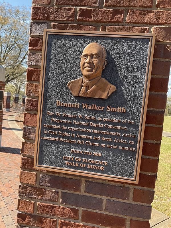
Rev. Dr. Bennett W. Smith, as president of the Progressive National Baptist Convention, expanded the organization internationally. Active in Civil Rights in America and South Africa, he counseled President Bill Clinton on racial equality. — — Map (db m219184) HM
On West Montgomery Road at Kelly Drive on West Montgomery Road.
Side 1
Born in 1930 in Montgomery, Gray was among the foremost civil rights attorneys of the 20th century. Forced by segregation to leave Alabama to attend law school, he vowed to return and "destroy everything segregated I could find." . . . — — Map (db m101898) HM
On North Claiborne Street at Dauphin Street, on the left when traveling south on North Claiborne Street.
(front side)
Mobile’s Hidden Figures initiative originated from the Mobile United Leadership Mobile’s Class of 2017 inaugural Diversity and Inclusion team. The objective is to raise awareness of diverse community members . . . — — Map (db m117243) HM
On Dexter Avenue at South Hull Street, on the right when traveling east on Dexter Avenue.
Side 1
Born in 1930 in Montgomery, Gray was among the foremost civil rights attorneys of the 20th century. Forced by segregation to leave Alabama to attend law school, he vowed to return and "destroy everything segregated I could find." . . . — — Map (db m80842) HM
On East 13th Street at South Walker Street, on the right when traveling east on East 13th Street.
Bill Clinton lived in this
house with his mother and
stepfather, Roger Clinton, from
1950 until 1953. During those
years, the future president
attended kindergarten and first
grade. Billy, as he was known
then, loved to play with . . . — — Map (db m159746) HM
On East Division Street at South Main Street, on the left when traveling east on East Division Street.
March 12, 1999. On this day two Hope natives
visited the Hope Visitor Center and museum.
President William Jefferson Clinton, in town to
dedicate his restored birthplace house, was
escorted through the center by life-long friend
Thomas Franklin . . . — — Map (db m161917) HM
Near Dean Kumpuris Street at East 3rd Street, on the right when traveling north.
Constructed in 1899, the Choctaw Route Station served as a passenger depot for the Choctaw, Oklahoma and Gulf Railroad Company, before becoming the property of the Rock Island Railroad in 1902.
The station served as a major passenger terminal on . . . — — Map (db m121451) HM
On West Maple Street at Garland Avenue, on the right when traveling east on West Maple Street.
The nation's 42nd president, William J. Clinton (1993-2001), and First Lady, Hillary Rodham Clinton, were faculty members of the University of Arkansas School of Law in the mid-1970s. Mr. Clinton started in 1973, teaching trade regulation, . . . — — Map (db m224737) HM
On Braddock Drive at Le Bourget Drive, on the right when traveling east on Braddock Drive.
This land was first traversed by Native Americans, called Tongva, (later known as the Gabrielinos). Under Spanish rule, it was settled as a portion of Rancho La Ballona. After Culver City was incorporated in 1917, the property became a horseracing . . . — — Map (db m49961) HM
"Preservation of one's own culture does not require contempt or disrespect of other cultures."
Cesar E. Chavez (1927-1993)
Cesar Chavez was a Mexican American Labor leader & cofounder of the United Farm Worker (UFW). Cesar Chavez was . . . — — Map (db m26874) HM
On Howell Road near Center Street and Diggles Road.
Hallie Morse Daggett was a refined woman educated in San Francisco, however, her deep love for her childhood home at the Black Bear Mine near Sawyers Bar drew her back to the mountains. She knew how to hunt, fish, ride, trap and shoot early in life . . . — — Map (db m57944) HM
Near Heritage Road, 0.7 miles west of Bayside Drive (Delaware Route 9), on the left when traveling west.
This VC-9C, serial number 73-1682, transported America's top leadership from 1975 until 2011. Much of that time it served as Air Force Two for Vice Presidents Walter Mondale, George H.W. Bush, Dan Quayle, Al Gore, and Dick Cheney.
It also . . . — — Map (db m142564) HM
On West 18th Street at Baynard Boulevard on West 18th Street.
African American Medal of Honor Recipients Memorial The Medal of Honor takes its place in our country as the highest award for military valor. The honor, awarded by the President in the name of Congress, may only be accorded an . . . — — Map (db m173924) HM WM
On Kalorama Road Northwest east of 17th Street Northwest, on the right when traveling west.
In 1947, the building on your left opened as the National Arena, a public roller rink and bowling alley. It also hosted professional wrestling, roller derbies, and rock concerts. In 1986 it became the Citadel Motion Picture Center, where . . . — — Map (db m130710) HM
On Randolph Place Northwest at 2nd Street Northwest, on the right when traveling west on Randolph Place Northwest. Reported missing.
Bloomingdale of the 1940s and '50s was a village of high expectations. Within a block of this sign lived four young women who grew up to be judges.
Anna Diggs Taylor rose to chief judge of the U.S. District Court in Michigan. The . . . — — Map (db m130843) HM
On M Street Northwest west of 15th Street Northwest, on the left when traveling west.
This church started on Capitol Hill in 1821 as Israel Bethel, was founded by African Americans denouncing White racism at Ebenezer Methodist Episcopal Church. Later, Pastor Henry McNeal Turner helped persuade President Lincoln to accept Black . . . — — Map (db m30056) HM
On 37th Street Northwest at O Street Northwest, on the right when traveling north on 37th Street Northwest.
Georgetown University, founded in 1789 by the Reverend John Carroll as a school for students of "Every Religious Profession," is the oldest Catholic university in America, administered by the Jesuits since 1805. According to the 1831 University . . . — — Map (db m121208) HM
On 34th Street Northwest at O Street Northwest, on the right when traveling south on 34th Street Northwest.
Throughout its history, Georgetown has been at the center of Washington’s political and social life. As early as 1789, Washington and Jefferson met in a local tavern to plan the new capital. The Marquis de Lafayette, who fought with us in the . . . — — Map (db m97757) HM
On Independence Avenue Southwest east of 9th Street Southwest, on the right when traveling east. Reported permanently removed.
Welcome to Earth Day Park Earth Day Park is a living example of the United States Government’s commitment to environmentally conscious landscape design and use of renewable resources. As part of the celebration of Earth Day 1994, President . . . — — Map (db m99344) HM
On Independence Avenue Southwest at 9th Street Southwest, on the right when traveling east on Independence Avenue Southwest.
Earth Day Park was originally dedicated on April 22, 1996, in a culmination of efforts by the U.S. Department of Energy and U.S. General Services Administration to transform a neglected, vacant lot into a green oasis. the park's most recent . . . — — Map (db m184560) HM
On L'Enfant Plaza Southwest south of Independence Avenue Southwest, on the right.
The 3 kW photovoltaic (PV) system, attached to the railing running alongside the large wall to your left, converts the sun's energy directly into electricity. The array will produce up to 4,500 kilowatt-hours of electricity each year, enough to run . . . — — Map (db m111485) HM
On 7th Street Southwest south of G Street Southwest, on the right when traveling north. Reported unreadable.
Who are these famous Civil Rights leaders?
Barbara Jordan (upper left)(some text missing due to illegibility)
Patsy Mink (wearing... (some text missing due to illegibility) ... supporter of civil rights . . . — — Map (db m130649) HM
On 7th Street Southwest south of G Street Southwest, on the left when traveling south.
Dr. Dorothy Height worked to advance women's, civil, and human rights with many of our nation's leaders. How many can you recognize?
Back
Dr. Dorothy Height
Has lived at 700 7th Street, SW since 1983. As President Emmerita . . . — — Map (db m112797) HM
On Independence Avenue Southwest at West Basin Drive Southwest, on the left when traveling east on Independence Avenue Southwest. Reported permanently removed.
“With this faith we will be able to hew out of the mountain of despair a stone of hope. With this faith, we will be able to transform the jangling discords of our nation into a beautiful symphony of brotherhood. With this faith, we will be able . . . — — Map (db m46398) HM
Near West Basin Drive Southwest at Independence Avenue Southwest. Reported permanently removed.
At this site will be erected the Martin Luther King, Jr .Memorial. The memorial will embody the man, the movement and the message. It will honor this 20th century visionary who brought about change through the principles of nonviolence and . . . — — Map (db m208) HM
On Ohio Drive Southwest south of West Basin Drive Southwest, on the right when traveling north.
The original 1997 memorial barely hinted at Franklin Roosevelt's paralyzed legs - much as FDR had during his Presidency. Roosevelt's battle with polio was not a secret. The president worried that if people knew he was unable to walk, his . . . — — Map (db m197626) HM
Near Freedom Avenue, 0.3 miles south of Parker Street, on the left when traveling south.
Civil rights activists Rosa Parks was born on February 4, 1913, in Tuskegee, Alabama. Her refusal to surrender her seat to a white passenger on a Montgomery, Alabama bus spurred a city-wide boycott. The City of Montgomery had no choice but lift . . . — — Map (db m177878) HM
On Front Street, on the right when traveling south.
Built in 1890 on the waterfront as a two-family dwelling for the base commandant and paymaster, this building was known as Quarters A and B. It was converted into a single-family residence in 1911. President William Howard Taft visited this site in . . . — — Map (db m32659) HM
On Front Street at Caroline Street, on the right when traveling south on Front Street.
Built in 1890 as quarters for Navy officers, the Little White House later was used by American Presidents William Howard Taft, Harry S. Truman, Dwight Eisenhower, John F. Kennedy, Jimmy Carter and Bill Clinton. Truman used the facility as a vacation . . . — — Map (db m32655) HM
On Washington Avenue (U.S. 51) south of 17th Street, on the right when traveling south.
President William Jefferson Clinton, 42nd President of The United States accompanied by his wife, Hillary and Vice President and Mrs. Albert Gore, Jr. spoke to a crowd of over 6000 in Cairo, Illinois at The Cairo Public Library on Friday, August 30, . . . — — Map (db m161195) HM
Near NW Railroad Street near NW Curtis Street, on the left when traveling west.
Delaware, 1st State
December 7, 1787
1609 • Henry Hudson visited Delaware Bay
1638 • Swedish colonists established Fort Christina, Delaware's first permanent settlement, and founded the colony of New Sweden
1655 • Dutch captured New . . . — — Map (db m47214) HM
Near Rock Street at Mark Twain Avenue (North 3rd Street) (Business U.S. 36).
Built in 1935 as a memorial to Mark Twain on his 100th birthday, the current lighthouse is the second to be built at this site.
• 1934 Construction on the Mark Twain Memorial Lighthouse began. The metal framework structure, covered . . . — — Map (db m131895) HM
On Delmar Boulevard at Princeton Avenue, on the right when traveling west on Delmar Boulevard.
A lifetime of community involvement began when the rattling sound from a manhole cover on a University City street prevented her children from sleeping.
Getting involved to solve this problem would lead Harriet Woods to serve as:
- . . . — — Map (db m133124) HM
On Maple Avenue, 0.1 miles west of Buenavista Road, on the right when traveling west.
On June 11, 1995, President William Jefferson Clinton and Speaker of the U.S. House of Representatives Newt Gingrich met at the invitation of the Congress of Claremont Senior Citizens, Inc. to debate issues affecting senior citizens. During the . . . — — Map (db m109337) HM
On Mt. Pleasant Avenue at Wagner Avenue, on the left when traveling north on Mt. Pleasant Avenue.
President Bill Clinton and Vice President Al Gore greeted the public and parochial school children of Wallington, N.J. on this site at the invitation of Mayor Walter G. Wargacki March 11, 1996 — — Map (db m76889) HM
On Fulton Street at St. Felix Street, on the right when traveling east on Fulton Street.
This park is named for Betty Carter (1929-1998), a legendary African American jazz artist who was a prominent resident of Fort Greene.
The property, located opposite the Brooklyn Academy of Music (BAM), once was home to small-scale . . . — — Map (db m242877) HM
On Fulton Street east of St. Felix Street, on the right when traveling east.
What was here before?
The property was once home to small-scale residential and commercial buildings from the late 19th and early 20th centuries that fell into disrepair and abandonment by the late 1970s. In the early 1980s the City took . . . — — Map (db m242882) HM
On Cooper Square at East 8th Street, on the right when traveling north on Cooper Square.
The Cooper Union for the Advancement of Science and Art is America’s first free college. Founded by progressive thinker/abolitionist/inventor Peter Cooper, its doors were opened to all, regardless of race, religion, gender or social status.
Its . . . — — Map (db m136713) HM
On West 155th Street near Frederick Douglass Boulevard, on the left when traveling west. Reported permanently removed.
This basketball court is named in honor of Gregory Marius (1958-2017), founder of the popular Entertainers Basketball Classic at Rucker Park. Born in Harlem on March 18, 1958, Gregory Alexander Marius was a lifelong Harlem resident.
Marius . . . — — Map (db m136578) HM
On Frederick Douglass Boulevard north of West 155th Street, on the right when traveling north.
Who is this basketball court named for?
This basketball court is named in honor of Gregory Alexander Marius (1958-2017), founder of the popular Entertainers Basketball Classic at Rucker Park and lifelong Harlem restaurant.
Marius . . . — — Map (db m228712) HM
On Frederick Douglass Boulevard north of West 155th Street, on the right when traveling north.
Who is this basketball court named for?
This basketball court is named in honor of Gregory Alexander Marius (1958-2017), founder of the popular Entertainers Basketball Classic at Rucker Park and lifelong Harlem restaurant.
Marius . . . — — Map (db m228713) HM
On North Main Street (Route 332) at Ontario Street on North Main Street.
November 11
Canandaigua Pickering Treaty 1794 - 1994
Solemn agreements were renewed between the United States of America and the Haudenosaunee (Six Nations of Indians). U.S.A. Representative Congresswoman Louise Slaughter conveyed a message, . . . — — Map (db m63998) HM
Near Desert Storm Drive, 0.1 miles west of Yadkin Road & Reilly Street intersection when traveling east.
During his long and illustrious career, Major Meadows embodied all of those qualities that mark the unique individuals serving in Special Operations Forces. Major Meadows’ extraordinary achievements throughout his dedicated service with Army Special . . . — — Map (db m31484) HM
On Lakeside Avenue East west of East 9th Street, on the right when traveling west.
Carl Burton Stokes (1927-1996). Carl Stokes was born in Cleveland on June 21, 1927. Recognized for his trailblazing service as a public official, Stokes is one of the few American politicians whose career spanned all three branches of state . . . — — Map (db m202302) HM
On Kinsman Road (U.S. 422) at East 147th Street, on the right when traveling east on Kinsman Road.
Jim Brown,
Hall of Fame Athlete, Actor, Activist, Entrepreneur, Motivator. As a professional football player Jim Brown has been called the “G.O.A.T.,” The Greatest of All Time. He was born James Nathaniel Brown February 17, 1936 in . . . — — Map (db m137059) HM
On Eden Avenue at Piedmont Avenue, on the right when traveling south on Eden Avenue.
Albert B. Sabin developed the oral, live-virus polio vaccine
at the University of Cincinnati College of Medicine and
Children’s Hospital Research Foundation, where between 1939
and 1969, he conducted his most significant research.
His vaccine . . . — — Map (db m171669) HM
On Market Street north of East Front Street, on the right when traveling north.
On August 19, 1996, this building was rededicated to honor the achievements of
Thomas D. Lambros as lawyer, jurist and proud citizen of the United States of America.
This son of Greek immigrants was born February 4, 1930, in Ashtabula, . . . — — Map (db m202484) HM
On 2nd Street at Market Street, in the median on 2nd Street.
Here is situated the nationally renowned historic and contemporary urban hub of the City of Harrisburg and the Greater Harrisburg Metropolitan Area. Laid out as the center focus of John Harris, Jr.'s plan in 1785 when Harrisburg was a launching . . . — — Map (db m6592) HM
Near Memorial Boulevard west of Exchange Street, on the right when traveling west.
In 1998 the Woonasquatucket River was designated by President Clinton as one of 14 American Heritage Rivers. The river has contributed mightily to the historic and industrial legacy and growth of the City.
The Environmental Protection . . . — — Map (db m222675) HM
On West 4500 N Street, 0.7 miles west of North 10000 W Street, on the left when traveling west.
442nd Regimental Combat Team, 100th Infantry Battalion, Military Intelligence Service (MIS)
Formed during World War II, these three US Military units were comprised of Japanese-American young men from the US mainland, Hawaii and from ten . . . — — Map (db m1332) HM
On Wythe Street just east of North Patrick Street (U.S. 1), on the right when traveling west.
Enforced racial segregation in Alexandria meant separate, poorly funded schools for the City's African American students. Here, in the African American neighborhood then known as Uptown, a new school was built in 1920 at 901 Wythe Street for . . . — — Map (db m182228) HM
On Memorial Avenue west of Virginia Route 110, in the median.
[Quotes are etched in glass on the top of the memorial:]
I'm still so very proud
of my Naval service.
I would do it again if I could.
Mildred Pearl Lane, Yeoman 2nd Class, US Navy, World War I
This award doesn't
have . . . — — Map (db m137193) WM
On Marshall Drive at Richmond Highway on Marshall Drive. Reported permanently removed.
Dedicated on May 5, 1960, the 15th anniversary of the liberation of the Netherlands, the Netherlands Carillon was presented "From The People Of The Netherlands To The People Of The United States" in gratitude for assistance given during and after . . . — — Map (db m129467) HM
On West Main Street (Business U.S. 250) west of 13th Street Northwest, on the left when traveling east.
The Charlottesville Mural Project and New City Arts Initiative, in partnership with Graduate Charlottesville and UVA Arts, present a mural by Poet Laureate Rita Dove and artist David Guinn
This is a collaborative . . . — — Map (db m246891) HM
Near East Massachusetts Street west of North Washington Street (Wisconsin Highway 87), on the left when traveling west.
Gaylord Anton Nelson (1916–2005), known worldwide as the founder of Earth Day, was the son of a country doctor and a nurse. Born the third of four children on June 4, 1916, at Clear Lake, Wisconsin, 28 miles from here, Nelson canoed the . . . — — Map (db m14796) HM
On Randall Avenue at McComb Avenue, on the right when traveling east on Randall Avenue.
right side
In 1866, following the American Civil War, Congress created six all African American Army units which later merged into four (9th and 10th Cavalry - 24th and 25th Infantry Regiments). Composed of former slaves, freemen, and . . . — — Map (db m95173) HM
On Menors Ferry Road near Teton Park Road, on the left when traveling west.
This rustic Episcopal chapel, constructed in 1925, held the first services on July 26 of that year. Prior to its construction, worshippers traveled 12 miles over rough roads to the town of Jackson. Today, that is just a short car ride away, but in . . . — — Map (db m97628) HM
On Donegall Square North (Northern Ireland Route A1) at Donegall Place, on the right when traveling east on Donegall Square North.
In the 17th century Belfast was little more than a village, but by the end of the 19th century it had become a dynamic industrial powerhouse, its mighty shipbuilding, linen, engineering and tobacco industries fueled by a rapidly growing . . . — — Map (db m133776) HM
On Shipquay Place at Guildhall Square, on the right when traveling west on Shipquay Place.
City under siege
The city was twice besieged for over a hundred days. In 1649 the garrison held out against royalist troops during the English Civil War. Forty years later the city supported Protestant William III against Catholic James II . . . — — Map (db m70943) HM