25 entries match your criteria.
Related Historical Markers
By Craig Swain, May 11, 2011
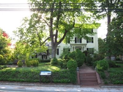
Marker and Harrison Hall
SHOWN IN SOURCE-SPECIFIED ORDER
| 1 ► Virginia, Loudoun County, Leesburg — Lee Comes to Leesburg — Conference at Harrison Hall — |
| On North King Street (Business U.S. 15) at North Street, on the right when traveling south on North King Street. | |||
| 2 ► Virginia, Loudoun County, Leesburg — Mile Hill — Cavalry Clash — |
| On Tutt Lane (Virginia Route 740) west of Victory Lane, on the left when traveling west. | |||
| 3 ► Virginia, Loudoun County, Leesburg — F-6 — Sharpsburg (Antietam) Campaign — |
| On James Monroe Highway (U.S. 15) at Whites Ferry Road (Local Route 655), on the right when traveling south on James Monroe Highway. | |||
| 4 ► Maryland, Montgomery County, Dickerson — White’s Ferry — Invasion or Liberation? — Antietam Campaign 1862 — |
| Near Whites Ferry Road, 0.1 miles south of River Road, on the right when traveling west. | |||
| 5 ► Maryland, Montgomery County, Dickerson — White’s Ford — Crossing the Potomac — Antietam Campaign 1862 |
| Near Martinsburg Road, 2.5 miles west of Darnestown Road (Maryland Route 28), on the right when traveling west. Reported permanently removed. | |||
| 6 ► Maryland, Montgomery County, Dickerson — White's Ford — A Civil War Crossing and a Desperate Escape — Chesapeake and Ohio Canal National Historical Park — |
| Near Martinsburg Road, on the right when traveling south. | |||
| 7 ► Maryland, Montgomery County, Poolesville — Edwards Ferry — Strategic Crossing — Gettysburg Campaign — |
| On Edward's Ferry Road, on the right. | |||
| 8 ► Maryland, Montgomery County, Poolesville — Poolesville — Warm Reception — Antietam Campaign 1862 — |
| On Fisher Avenue / Whites Ferry Road (Maryland Route 107) at Elgin Road / Beallsville Road (Route 109), on the right on Fisher Avenue / Whites Ferry Road. | |||
| 9 ► Maryland, Montgomery County, Dickerson — Monocacy Aqueduct — Too Tough To Crack — Antietam Campaign 1862 — |
| Near Mouth of Monocacy Road at Dickerson Road (Maryland Route 28). | |||
| 10 ► Maryland, Frederick County, Dickerson — Sugarloaf Mountain — A Signalman’s Lot — Antietam Campaign 1862 — |
| On Comus Road (Maryland Route 95) at Sugarloaf Mountain Road, on the right when traveling west on Comus Road. | |||
| 11 ► Maryland, Montgomery County, Dickerson, Comus — Mt. Ephraim Crossroads — Sharpshooters Hold the Line — Antietam Campaign 1862 |
| Near Old Hundred Road (Maryland Route 109) at Comus Road (Maryland Route 95), on the left when traveling north. Reported missing. | |||
| 12 ► Maryland, Frederick County, Urbana — Landon House — From Hospitality to Hospital — Antietam Campaign 1862 |
| Near Urbana Pike (Maryland Route 355) at Fingerboard Road (Maryland Route 80), on the right when traveling west. Reported permanently removed. | |||
| 13 ► Maryland, Frederick County, New Market — New Market — A New Town for a New Road — The Historic National Road - The Road That Built The Nation |
| On Main Street (Maryland Route 144) west of Prospect Street (Maryland Route 874), on the left when traveling west. Reported permanently removed. | |||
| 14 ► Maryland, Frederick County, Frederick — Jug Bridge — An engineering marvel for early America — The Historic National Road - The Road That Built The Nation |
| On Bowman’s Farm Road at Patrick Street (Maryland Route 144), on the right when traveling east on Bowman’s Farm Road. Reported permanently removed. | |||
| 15 ► Maryland, Frederick County, Frederick — City Hall — Former Frederick County Courthouse — Antietam Campaign 1862 — |
| On Counsil Street, on the right when traveling east. | |||
| 16 ► Maryland, Frederick County, Braddock Heights — Hagan’s Tavern — If walls could talk.. — |
| On Old National Pike (Alternate U.S. 40) at Edgemont Road, on the right when traveling west on Old National Pike. | |||
| 17 ► Maryland, Frederick County, Middletown — Middletown — Enemies and Friends — Antietam Campaign 1862 — |
| On West Main Street (Alternate U.S. 40) at Elm Street, on the left when traveling west on West Main Street. | |||
| 18 ► Maryland, Frederick County, Jefferson — Jefferson — Prowling Confederates and Pretty Girls — |
| On Lander Road, on the right when traveling north. | |||
| 19 ► Maryland, Frederick County, Burkittsville — Burkittsville — Houses of Worship Become Houses of Misery — Antietam Campaign 1862 — |
| On East Main Street at Potomac Street (Maryland Route 17), on the right on East Main Street. | |||
| 20 ► Maryland, Frederick County, Burkittsville — The Battle of South Mountain — |
| On Gapland Road at Arnoldstown Road, on the right when traveling west on Gapland Road. | |||
| 21 ► Maryland, Washington County, Boonsboro — The Battle for Fox’s Gap — “Hell is empty and all the devils are here.” — Antietam Campaign 1862 — |
| On Reno Monument Road at the Appalachian Trail, on the left when traveling west on Reno Monument Road. | |||
| 22 ► Maryland, Washington County, Middletown — Battle at South Mountain — A Natural Barrier — Antietam Campaign 1862 — |
| On Old National Pike (Alternate U.S. 40) at Washington Monument Road, on the right when traveling east on Old National Pike. | |||
| 23 ► Maryland, Washington County, Boonsboro — Boonsboro — Lee's Headquarters — Antietam Campaign 1862 — |
| On Old National Pike (Alternate U.S. 40) 1.2 miles east of Gilardi Road, on the right when traveling east. | |||
| 24 ► Maryland, Washington County, Keedysville — Keedysville — Headquarters and Hospital Town — Antietam Campaign 1862 — |
| On Taylor Drive at North Main Street (Maryland Route 845), in the median on Taylor Drive. | |||
| 25 ► Maryland, Washington County, Sharpsburg — Middle Bridge |
| On Boonsboro Pike (State Highway 34), on the right when traveling east. Reported missing. | |||